2019 International Conference on Computer Science, Communications and Big Data (CSCBD 2019) ISBN: 978-1-60595-626-8
To Go Where we Have Never Been to: 3D Real-Time Visualizatuion of
Terrain Database
Nan WANG
1,2,*, Xiang-dong WANG
1,2and Hai-rong SUN
1,21
Key Laboratory of Submarine Geosciences and Prospecting Techniques, Ministry of Education, Ocean University of China, Qingdao 266071, P.R. China
2
College of marine Geosciences, Ocean University of China, Qingdao 266100, P.R. China
*Corresponding author
Keywords: Multi-beam system, Bathymetric data, Seafloor, Underwater terrain, 3D visualization.
Abstract. 3D visualization is important content of digital terrain information space performance. Based on high-precision bathymetric data by NOAA and high-resolution satellite image data, this paper construct the seafloor at the Mariana Trench and the lake Superior scene data model, which roaming anywhere at any angle of view in the 3D terrain scene are interactively obtained and dynamically presented the nature looking in real-time truly and intuitively using Vega-Prime system. As the benefit with using 3-D visualization technology, we can go to visit places where we have never been to.
Introduction
In recent years, with the rapid development of computer technology, especially computer graphics 3D visualization technology and virtual reality technology, the intuitive and vivid 3D terrain visualization system has become a research hot spot[1]. Compared with the characteristic 2D terrain which is monotonous and lack of intuition [2], 3D terrain can transform geographic data and its analysis results into direct visible information[3-5]. As a result, roaming anywhere at any angle of view in the 3D terrain scene are interactively obtained and dynamically presented the nature looking in real-time truly and intuitively[4, 6, 7].
Using 3D visualization technology, we can go to visit places we have never been to[8]. In this paper, we use 3D simulation technology to observe the oceanic trenches that are several kilometers deep and the terrain scenes on the beautiful Lake Superior.
Data Acquisition and Processing
Data Acquisition
Figure 1. Geographic location of multi-beam survey area at the Mariana Trench.
[image:2.595.84.509.338.464.2]The Great Lake Superior bathymetric data have be obtained by the program which was managed by NCEI and relied on the cooperation of NOAA/Great Lakes Environmental Research Laboratory, NOAA/National Ocean Service, the Canadian Hydrographic Service. The accuracy of the constructed Grid DEM data is 3 arc-second (~90 meter cell size) grid.
Figure 2. Geographic location of The Great Lake Superior.
Data Processing
The visual images of seafloor and terrestrial 3D topography include two parts: underwater geomorphic image and terrestrial remote sensing image. The underwater geomorphological image can be used to represent the detailed features of the underwater targets information. The underwater DEM data can be colored according to the different depth values, and the colored texture rendering seafloor information can be used to represent the underwater geomorphic information effectively. The landform high-resolution satellite imagery have be obtained by Google-Earth (January 2019).
Figure 3. Seafloor image represented according to depth.
Pacific Ocean
[image:2.595.199.391.604.759.2]Figure 4. Geomorphic image data fusion with Land satellite imagery and underwater DEM.
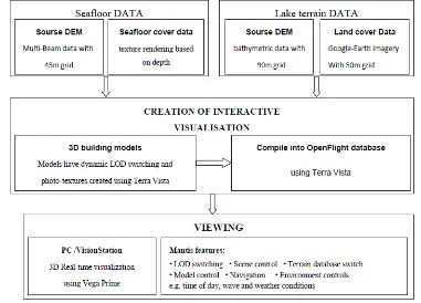
Construction of 3D Terrain Database
3D terrain database is constructed using the commercial modeling software Terra Vista(by Presagis Corporation), which Real-time 3D complex terrain database generation tool system software based on Windows platform, specially designed to process high-precision large-area terrain data, support multiple data format import and output in multiple database formats.
The DEM format terrain files and texture images are converted into the virtual simulation standard format Open-Flight format database model. The real-time visual simulation software Vega Prime(by MPI Corporation) is used to realize the visualization and roaming of 3D terrain scene. The workflow is as follows:
Figure 5. The process to create the interactive virtual database.
Key Technologies
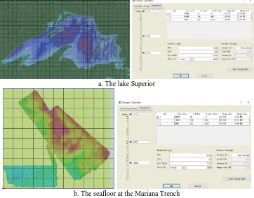
[image:3.595.105.486.353.627.2]Terrain Blocks and LOD Setting
Firstly a suitable grid structure and terrain block design should be developed. Secondly setting different levels of LOD, and improving the terrain height by optimizing different levels of LOD. When processing texture data, the virtual texture data set is cut and generated according to different LOD levels, and a virtual texture grid stack with different hierarchical resolutions are generated to ensure a visual seamless transition of different resolution images in the virtual scene display.
a. The lake Superior
[image:4.595.117.479.165.448.2]b. The seafloor at the Mariana Trench
Figure 6. Construction of Grid blocks and LOD setting of 3D terrain scene Database.
Real-time View Display of Terrain Scene
The scene management of the terrain scene database was realized by importing the database model of the Open-Flight format into the real-time visual simulation software Vega Prime.
Real-time control roaming can be realized by the VP Motion module. Controlling the changes of environmental elements such as illumination, cloud layer and wind speed over time can be realized by the ENV module. The water surface effect can be realized by the VP Marine module, and the interactive display of illumination and water objects can be realized to present natural looking of the environment.
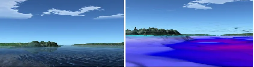
Now we have the opportunity to see the 3D scene of oceanic trench seafloor and the beautiful Lake Superior.
[image:4.595.158.440.625.781.2]Figure 8. 3D terrain Visualization of underwater.
Figure 9. 3D terrain Visualization of seafloor at the Mariana Trench.
Conclusion
Based on high-precision bathymetric data and terrestrial high-resolution satellite image data, this paper construct the seafloor at the Mariana Trench and the lake Superior scene data model. Roaming anywhere at any angle of view in the 3D terrain scene are interactively obtained and dynamically presented the nature looking in real-time truly and intuitively using Vega-Prime system. Using 3-D visualization technology, we can go to visit places where we have never been to. The system is a useful attempt to apply virtual reality technology to landscape tourism.
Acknowledgements
The authors thank National Centers for Environmental Information (NOAA) for obtaining the DEM datas of the Mariana Trench and the Lake Superior.
References
[1] Graciano A, Rueda AJ, Feito FR. Real-time visualization of 3D terrains and subsurface geological structures. ADV ENG SOFTW 2018; 115:314.
[2] Wilson JP. Digital terrain modeling. Geomorphology 2012; 137:107.
[3] Han-dan H, Jian-fei Z. Research on Real-Time Visualization of Large-scale 3D Terrain. Procedia Engineering 2012; 29:1702.
[4] Brown I, Jude S, Koukoulas S, Nicholls R, Dickson M, Walkden M. Dynamic simulation and visualisation of coastal erosion. Computers, Environment and Urban Systems 2006; 30:840.
[5] Mayer LA. Frontiers in Seafloor Mapping and Visualization. Marine Geophysical Researches 2006; 27:7.
[7] White M. Real-Time Optimally Adapting Meshes: Terrain Visualization in Games. International Journal of Computer Games Technology 2008; 2008:1.