CLOUD BASED PUBLIC BUS LOCATION
TRACKING AND NOTIFICATION APPLICATION
FOR MOBILE DEVICES
CHEE XIAN YANG
Faculty of Computer Science & Software Engineering
SUPERVISOR’S DECLARATION
I hereby declare that I have checked this thesis and in my opinion, this thesis is adequate in terms of scope and quality for the award of the degree of Bachelor of Computer Science (Computer System and Networking) with Honors.
_______________________________ (Supervisor’s Signature)
Full Name : DR SYAFIQ FAUZI BIN KAMARULZAMAN Position : SUPERVISOR Date : 10 January 2019 _______________________________ (Co-supervisor’s Signature) Full Name : Position : Date :
STUDENT’S DECLARATION
I hereby declare that the work in this thesis is based on my original work except for quotations and citations which have been duly acknowledged. I also declare that it has not been previously or concurrently submitted for any other degree at Universiti Malaysia Pahang or any other institutions.
_______________________________ (Student’s Signature)
Full Name : CHEE XIAN YANG ID Number : CA15094
CLOUD BASED PUBLIC BUS LOCATION TRACKING AND NOTIFICATION APPLICATION FOR MOBILE DEVICES
CHEE XIAN YANG
Thesis submitted in fulfillment of the requirements for the award of the degree of
Bachelor of Computer Science (Computer System and Networking)
Faculty of Computer Systems and Software Engineering UNIVERSITI MALAYSIA PAHANG
ACKNOWLEDGEMENTS
Firstly, I would like to express my deepest appreciation to my parents for always giving me encouragement and moral support for me to continue my study up to the degree level. Also, I would like to thank all the lecturers who educate me during my 4 years of study in Universiti Malaysia Pahang.
I must express my greatest gratitude to my supervisor, Dr. Syafiq Fauzi bin Kamarulzaman who always give me guidance through out the project development. It is a great honor to do this project under his supervision. He provided insight comment and outstanding technical advice as well as moral support to me all the time.
Lastly, I would like to thank to all my friends who had given me idea, guidance and sharing of knowledge throughout the project development.
ABSTRAK
Pada masa kini, pengunaan pengangkutan bas awam adalah salah satu fenomena yang biasa di Malaysia. Walau bagaimanapun, tanpa sistem pengurusan yang baik, perkhidmatan bas mungkin tidak dapat dilaksanakan secara efisien. Penumpang masih perlu menunggu lama untuk ketibaan bas di perhentian bas bersama dengan cuaca yang cukup panas dan mempunyai peluang yang tinggi terlepas bas. Oleh itu, ini adalah sistem pengesanan bas yang dibuat untuk menyelesaikan masalah tersebut. Aplikasi mudah alih berasaskan Android yang diintegrasikan dengan Google Map akan dicipta untuk menjejak lokasi bas awam dan memberikan anggaran masa ketibaan setiap bas kepada pengguna. Oleh itu, pengguna boleh pergi ke perhentian bas berdasarkan masa yang diberikan daripada menunggu di perhentian untuk bas datang. Pada masa yang sama, aplikasi mudah alih akan dicipta untuk pemandu bagi memberikan lokasi mereka kepada pengguna secara langsung dan aplikasi berasaskan web akan diwujudkan untuk syarikat bas untuk mendaftar laluan bas mereka, menguruskan pemandu mereka serta menguruskan bas yang dimiliki oleh syarikat tersebut. Keseluruhan sistem akan dibangunkan melalui kitaran RAD dan mempunyai empat fasa iaitu perancangan, perekaan sistem, pembinaan dan pemotongan fasa. Prototaip sistem dijangka dapat disiapkan setiap ulangan fasa pembinaan. Sistem ini bertujuan untuk memberikan manfaat kepada masyarakat atau orang yang sering menggunakan pengangkutan bas awam. Walau bagaimanapun, peningkatan masa depan sistem diperlukan untuk memastikan bateri telefon tidak habis begitu cepat disebabkan servis lokasi GPS dan sistem ini mungkin tidak dapat memberi manfaat kepada pengguna iOS pada peringkat awal.
ABSTRACT
Nowadays, public bus transportation had become more common in Malaysia. However, without a good management system, the bus service might not be fully utilized. Passenger still have to wait for long time under the hot weather for the bus to come and might have higher chances to miss the bus. Therefore, this is a real time bus tracking system developed to solve the problem. An Android based mobile application integrated with Google Map is created to stream the location of public buses in real time and provide estimated arrival time of each buses to the users. Hence, user can go to the bus stop based on the time given instead of waiting at the bus stop under the hot weather. At the same time, the mobile application will be created for the driver to provide their location to the user in real time and a web-based application will be created for the bus company to register their route, manage their driver as well as manage the buses that belong to the company. The whole system will be developed through the RAD cycle and having four phases which is requirement planning, user design, construction and cutover phase. The prototype of system is expected to deliver every loop of the construction phase. They system is aimed to give advantage to the community or people who often using public bus transportation. However, future enhancement to the system is needed to make sure that the phone battery does not drain so fast due to the GPS location service and the current constrain of this system is that it might not benefit to iOS users.
TABLE OF CONTENT DECLARATION TITLE PAGE ACKNOWLEDGEMENTS ii ABSTRAK iii ABSTRACT iv TABLE OF CONTENT v LIST OF TABLES x LIST OF FIGURES xi
LIST OF ABBREVIATIONS xiii
CHAPTER 1 INTRODUCTION 1 1.1 BACKGROUND 1 1.2 PROBLEM STATEMENT 2 1.3 OBJECTIVE 3 1.4 SCOPE 4 1.5 SIGNIFICANCE 4 1.6 THESIS ORGANIZATION 4
CHAPTER 2 LITERATURE REVIEW 6
2.1 INTRODUCTION 6
2.2 STUDIES ON TECHNOLOGY INVOLVED 6 2.2.1 GLOBAL SYSTEM FOR MOBILE COMMUNICATION 6 2.2.2 GLOBAL POSITIONING SYSTEM 7
2.2.3 MOBILE APPLICATION PLATFORM – ANDROID
OPERATING SYSTEM 9
2.3 COMPARISION OF MOBILE APPLICATION FRAMEWORK 11
2.3.1 XAMARIN 11
2.3.2 IONIC FRAMEWORK 12
2.3.3 INTEL XDK 13
2.4 COMPARISON OF MAPS API 13
2.4.1 GOOGLE MAPS API 13
2.4.2 BING MAPS API 14
2.4.3 APPLE MAPS API 16
2.5 REVIEW OF EXISTING SYSTEM 16
2.5.1 ASIA PASIFIC UNNIVERSITY (APU) BUS TRACKING
SYSTEM 17
2.5.2 UiTM CAMPUS BUS TRACKING SYSTEM USING ARDUINO BASED AND SMARTPHONE APPLICATION
(UiTM BUS CHECKER) 18
2.5.3 IoT BASED SCHOOL BUS TRACKING AND ARRIVAL
TIME PREDICTION SYSTEM. 20
2.5.4 COMPARISON OF EXISTING SYSTEM 22
2.6 Summary 23
CHAPTER 3 METHODOLOGY 24
3.1 INTRODUCTION 24
3.2 RAPID APPLICATION DEVELOPMENT (RAD) 24
3.2.1 REQUIREMENT PLANNING 25
3.2.2 USER DESIGN 25
3.2.2.1 Use Case Diagram 26
3.2.2.3 General Flowchart of The Prototype 27
3.2.2.3.1 BusSeeker (Passenger Apps) 27
3.2.2.3.2 BusSeeker (Driver Apps) 29
3.2.2.3.3 Bus Seeker Management System 30
3.2.2.4 USER INTERFACES 31
3.2.3 CONSTRUCTION PHASE 38
3.2.4 CUTOVER PHASE 39
3.3 GENERAL ARCHITECTURE AND PACKAGE MODULES 39
3.3.1 GENERAL ARCHITECTURE 39 3.3.2 PACKAGE MODULE 40 3.3.2.1 Tracking Module 41 3.3.2.2 Notify Driver 41 3.3.2.3 Driver Login 41 3.3.2.4 Activate Route 41 3.3.2.5 Company Registration 41 3.3.2.6 Company Login 41 3.3.2.7 Manage Bus 42 3.3.2.8 Manage Route 42 3.3.2.9 Manage Driver 42 3.3.2.10 View Feedback 42
3.4 HARDWARE AND SOFTWARE 42
3.4.1 HARDWARE REQUIREMENT 42
3.4.2 SOFTWARE REQUIREMENT 43
CHAPTER 4 RESULTS AND DISCUSSION 44
4.1 INTRODUCTION 44
4.2 IMPLEMENTATION 44
4.2.1 TOOLS AND TECHNOLOGY 44
4.2.2 DATABASE IMPLEMENTATION 46
4.2.3.1 BusSeeker Driver Apps 47
4.2.3.2 BusSeeker Passenger Apps 50
4.2.3.3 BusSeeker Management System 54
4.3 TESTING AND RESULT DISCUSSION 58
4.4 USER MANUAL 59 CHAPTER 5 CONCLUSION 60 5.1 INTRODUCTION 60 5.2 PROJECT CONSTRAINTS 61 5.3 FUTURE WORK 62 REFERENCES 63
APPENDIX A GANTT CHART 65
APPENDIX B USER ACCEPTANCE TEST 66
APPENDIX C USER MANUAL 76
1.0 GENERAL INFORMATION 76
1.1 System Overview 76
1.2 Organization of the Manual 76
2.0 SYSTEM SUMMARY 77
2.1 System Configuration 77
2.2 User Access Level 77
2.3 Contingencies and Alternate Mode of Operation 77
3.0 GET STARTED 78
3.1 BusSeeker (Driver Apps) 78
3.1.2 Activate Route 78
3.1.3 Location Tracking 79
3.2 BusSeeker (Passenger Apps) 80
3.2.1 Bus Stop and Route Selection 80
3.2.2 Search Bus 81
3.2.3 Provide Feedback 83
3.3 BusSeeker Management System 83 3.3.1 Management System Login Page 83 3.3.2 Management System Sign Up Page 84
3.3.3 Manage Bus 85
3.3.4 Manage Route 85
3.3.5 Manage Driver 87
LIST OF TABLES
Table 1.1 Problem statements in the project 2 Table 2.1 Comparison of features between maps provided by three company. 16
Table 3.1 Hardware requirement 42
LIST OF FIGURES
Figure 2.1 GSM location tracking through the process called triangulation 7 Figure 2.2 GPS localization through trilateration. 8 Figure 2.3 AGPS provide assisting position information to the smartphone. 9 Figure 2.4 Difference between traditional Xamarin with Xamarin Forms 12
Figure 2.5 Bing’s Isoshrone API 15
Figure 2.6 Bing’s Snap-to-Road API 15 Figure 2.7 Asia Pacific University (APU) Bus Tracking System webpage. 18 Figure 2.8 Overall system architecture of UiTM Bus Checker. 19 Figure 2.9 Overall UiTM Bus Tracking System 19 Figure 2.10 Overall system architecture diagram 21 Figure 2.11 Travelling path of school bus, scheduled and predicted arrival time of
bus. 21
Figure 3.1 RAD phases. 25
Figure 3.2 Use Case Diagram 26
Figure 3.3 Context Diagram 27
Figure 3.4 Flow Chart of BusSeeker (Passenger Apps) 28 Figure 3.5 Flow Chart of BusSeeker (Driver Apps) 29 Figure 3.6 Flow Chart of BusSeeker Management System 30 Figure 3.7 GUI of BusSeeker mobile apps for passengers. 31 Figure 3.8 GUI of BusSeeker mobile apps for driver. 32
Figure 3.9 Sign up page 32
Figure 3.10 Login page. 33
Figure 3.11 Bus adding and deleting page. 33
Figure 3.12 Adding bus route. 34
Figure 3.13 Delete bus route. 35
Figure 3.14 Showing detail of each route. 35 Figure 3.15 Register driver to the system. 36 Figure 3.16 Update driver information. 37
Figure 3.17 User feedback 37
Figure 3.18 Update company information 38 Figure 3.19 General architecture of the system. 40 Figure 3.20 System package module. 40
Figure 4.2 Microsoft Azure 45 Figure 4.3 Microsoft Azure portal interface for app service. 45 Figure 4.4 Entity Relationship Diagram (ERD) 46 Figure 4.5 Driver login interface 47 Figure 4.6 Route activation interface 47
Figure 4.7 Tracking interface 48
Figure 4.8 User interface of BusSeeker passenger apps. 50
Figure 4.9 Search bus 51
Figure 4.10 Notification 52
Figure 4.11 Feedback 52
Figure 4.12 Exit confimation dialog 53 Figure 4.13 Management system login page 54 Figure 4.14 Management system signup page 54
Figure 4.15 Bus management page 55
Figure 4.16 Route management page (add new route) 55
Figure 4.17 Search route 56
Figure 4.18 Route details 56
Figure 4.19 Driver management page. 57 Figure 4.20 Update driver information 57 Figure 4.21 Feedback management page 58 Figure 4.22 Update company information 58
LIST OF ABBREVIATIONS
A-GPS Assisted Global Positioning System API Application Programming Interface AXML CPU CSS DBaaS DFD ERD ETSI GPRS GPS GSM HDD HTML HTTP IC ID iOS IoT IP KML LOS LRT LTE PHP RFID SDLC SDM SIM SMS SSD TCQSM TDMA TIFF
Article XML Markup Language Central Processing Unit
Cascading Style Sheets Database-as-a-service Data Flow Diagrams
Entity Relationship Diagram
European Telecommunication Standards General Packet Radio Service
Global Positioning System Global System for Mobile Hard Drive Disk
Hyper-Text Markup Language Hypertext Transfer Protocol Identity Card
Identity
Iphone Operating System Internet of Thing
Internet Protocol
Keyhole Markup Language Level of Service
Light Rail Transit Long Term Evolution Personal Home Pages
Radio Frequency Identification System Development Life Cycle System Development Methodology Subscriber Identity Module
Short Message Service Solid State Drives
Transit Capacity and Quality of Service Manual Time Division Multiple Access
UI UML Wi-Fi XAML
User Interface
Unified Modeling Language Wireless Fidelity
CHAPTER 1
INTRODUCTION
1.1 BACKGROUND
Around the world, public bus services have undoubtedly play a very important role to provide transportation and mobility for community especially for those who can’t afford for the ownership of car. However, public bus transportation services are not the first choice of urban travel in Malaysia. According to the Nielsen Global Survey of Automotive Demand, Malaysia ranked third in the world with 93% of car ownership. The reasons behind this is because public transport is not as attractive as private vehicle such as inflexibility, no direct access, longer travel and waiting time and unsafe when travelling (Kamarudin Ambak & Rozmi Ismail, 2012). In fact, public bus transportation does bring a lot of benefit to the community. It can help to reduce congestion, reduce air pollution as well as saving transportation fee.
The Global Positioning System (GPS) is a navigation system that use satellite technology to pinpoint or determine the geographical location of ground object. The GPS technology was initially used by United State military in early 1970s and is available for general use nowadays. GPS is currently one of the most popular navigation system which integrated in many vehicle, and mobile devices. The geographical location obtained can be manipulated to derive useful information such as best route between two points, instantaneous speed, monitoring movement and locating lost person or stolen subjects (Vermaat, 2014).
Therefore, a mobile application can be created by applying the GPS technology to solve the schedule punctuality problem and long waiting time of public buses. From the application, user will be able to get the current location and the estimated arrival time of the buses in real time, so that they can plan their journey earlier and take their time to reach the bus stop instead of spending more time waiting for the bus. At the same time
another mobile application is needed for the driver to share the bus location in real time. User may also alert bus driver that he or she is waiting at particular bus stop so that the driver is ready to stop for the fetching purpose.
According to the survey done by the Malaysian Communication and Multimedia Commission (MCMC) based on the feedback from the poll’s 2787 respondents, the smartphone ownership among the internet user had reached 90.7% and 87.3% of them preferred to use mobile broadband as choice of internet access. Hence the mobile application is useful to track the location of buses anywhere, anytime and expected to give benefit to the user or passenger who often using public bus transportation thus encourage more people taking public bus transportation.
1.2 PROBLEM STATEMENT
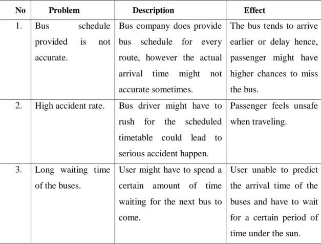
Table 1.1 Problem statements in the project
No Problem Description Effect
1. Bus schedule provided is not accurate.
Bus company does provide bus schedule for every route, however the actual arrival time might not accurate sometimes.
The bus tends to arrive earlier or delay hence, passenger might have higher chances to miss the bus.
2. High accident rate. Bus driver might have to rush for the scheduled timetable could lead to serious accident happen.
Passenger feels unsafe when traveling.
3. Long waiting time of the buses.
User might have to spend a certain amount of time waiting for the next bus to come.
User unable to predict the arrival time of the buses and have to wait for a certain period of time under the sun.
According to the Table 1.1 above, there are several problems are facing by the public bus passenger everyday life in Malaysia. One of the problems is that the bus
schedule provided is not accurate. Bus company does provide the bus schedule for every route, however the actual arrival time might not accurate sometimes. The bus tends to arrive earlier or delay, hence passenger might have higher chances to miss the bus. Besides that, passengers have to spend a certain amount of time waiting for the bus to come to the bus stop. Passenger unable to predict the arrival time of the buses and have to wait for a certain period of time under the hot weather. According to a study done by the Universiti Teknologi PETRONAS Malaysia collaboration with Gadjah Mada University Indonesia on the passengers’ waiting time and punctuality of stage bus operation in Malaysia, the result showing an average punctuality index of 0.29 and expected waiting time of 28 minutes. Based on the punctuality index, by referring to the TCQSM 2003 standard the bus system service reliability is considered to LOS B, meaning that vehicles are slightly off headway (M. Napiah, I. Kamaruddin, & Suwardo, 2011). Lastly, high accident rate also one of the problems facing by the community. Passenger will fell unsafe since driver might have to rush for the scheduled timetable could lead to serious accident happen.
1.3 OBJECTIVE
The goal of this project is to develop a tracking system to convince the public bus user in Malaysia with the following objectives:
I. To develop an application for smartphone that use the GPS technology to track the actual public bus location in real time.
II. To develop an application for smartphone to notify the user the actual location of public buses with the estimated arrival time of each bus. III. To evaluate the applications fulfil the requirements through User
REFERENCES
(27 March, 2008). Retrieved from Centers for Medicare and Medicaid Services: https://www.cms.gov/Research-Statistics-Data-and-Systems/CMS-Information-Technology/XLC/Downloads/SelectingDevelopmentApproach.pdf
(2016). Retrieved from rapidvaluesolutions: https://www.rapidvaluesolutions.com/wp-content/uploads/2016/10/Mobile-Usage-Statistics-and-Trends-2016.pdf
AA, T. (12 November, 2017). 10 reasons why Android is still better than iOS. Retrieved from Android Authority: https://www.androidauthority.com/10-reasons-why-android-is-still-better-than-ios-145370/
Faccioni, A. (November, 2016). Retrieved from GPSports Systems: http://www.gpsports.com/gpsports_website/articles/GPS%20-%20What%20is%20it.pdf
Idesis, S. (16 August, 2017). What Is Rapid Application Development? Retrieved from outsystems: https://www.outsystems.com/blog/rapid-application-development.html (2016). INTERNET USERS SURVEY 2016: STATISTICAL BRIEF NUMBER TWENTY .
Cyberjaya, Selangor, Malaysia: Malaysian Communications and Multimedia Commission.
Jisha R.C, Aiswa rya Jyothindranath, & Sajitha Kumary L. (2017). IoT BASED SCHOOL BUS TRACKING. Advances in Computing, Communications and Informatics (ICACCI), 509-514.
Kamarudin Ambak, & Rozmi Ismail. (2012). Passengers Preference and Satisfaction of Public.
Australian Journal of Basic and Applied Sciences , 410-416.
Kendrick, J. (28 June, 2011). Smartphone for GPS Navigation is better than a dedicated device. Retrieved from ZDNet: https://www.zdnet.com/article/smartphone-for-gps-navigation-is-better-than-a-dedicated-device/
Lam, H. (21 January, 2015). Why, when, and how to use the Google Map API. Retrieved from Medium: https://medium.com/@helenflam/why-when-and-how-to-use-the-google-map-api-f5dfa35986dc
LavishT. (5 May, 2017). What is Xamarin? How does it help in cross-platform mobile app
development? Retrieved from The Windows Club:
http://www.thewindowsclub.com/what-is-xamarin-and-cross-platform-mobile-development
M. Napiah, I. Kamaruddin, & Suwardo. (2011). Punctuality index and expected average waiting. WIT Transactions on The Built Environment, Vol 116, 215-226. M.T.Kamisan. (2017). UiTM Campus Bus Tracking System Using. IEEE 15th Student
Conference on Research and Development (SCOReD) , 137-141.
Nilah Ravi Nair, & P. Sudheesh, . (2016). 2-D Airborne Vehicle Tracking Using Kalman Filter
. 016 International Conference on Circuit, Power and Computing Technologies
[ICCPCT].
Press Room. (17 April, 2014). Retrieved from Nielsen:
www.nielsen.com/my/en/press-room/2014/rising-middle-class-will-drive-global-automotive-demand.html Prusty, N. (8 March, 2015). Overview of Intel XDK. Retrieved from CodeProject:
https://www.codeproject.com/Tips/883716/Overview-of-Intel-XDK
Quinn, S. (n.d.). Open Web Mapping. Retrieved from Penn State university e-education: https://www.e-education.psu.edu/geog585/node/763
Richter, F. (8 August, 2013). Google Maps is the Most-Used Smartphone App in the World . Retrieved from statista: https://www.statista.com/chart/1345/top-10-smartphone-apps-in-q2-2013/
Shroff, R. (4 November, 2014). 5 reasons why Xamarin is the king of cross platform
development. Retrieved from Softweb Solution:
https://www.softwebsolutions.com/resources/5-reasons-why-xamarin-is-cross-platform-development-king.html
Tucker, J. (13 November, 2015). onic Framework: Features and Benefits in Mobile App
Development. Retrieved from BDaily News:
https://bdaily.co.uk/articles/2015/11/23/ionic-framework-features-and-benefits-in-mobile-app-development
Vermaat, M. E. (2014). Discovering Computers: Technology in a World is Computers. Mobile