American
Society of Range Management
The American Society of Range Management was created allied technologists, and to encourage professional improvement in 1947 to foster advancement in the science and art of grazing of its members.land management, to promote progress in the conservation and Persons shall be eligible for membership who are interested greatest sustained use of forage and soil resources, to stimu- in or engaged in practicing range or pasture management or late discussion and understanding of scientific and practical animal husbandry ; administering grazing lands; or teaching, range and pasture problems, to provide a medium for the or conducting research, or engaged in extension activities in exchange of ideas and facts among society members and with range or pasture management or related subjects.
T
he JOURNAL OF RANGE MAN- AGEMENT, published b&monthly, is the official organ of the American Society of Range Management. The Society, however, assumes no responsibility for the statements and opinions expressed by authors and contributors.Office, Executive Secretary. Address all inquiries and correspondence including memberships, renewals, replacements of JOURNALS, etc., to Executive Secretary, American Society of Range Management, P.O. Box 5041, Portland 13, Oregon. Dues. Membership dues should be sent to the Executive Secretary. The dues are $8.00 per year including a subscrip- tion to the JOURNAL OF RANGE MAN- AGEMENT. Dues for student members are $4.00 per year, including the JOURNAL. All subscriptions mailed outside the North American continent and insular possessions of the U. S. are $8.50 per year. Subscrip- tions must be paid in advance. Remit by draft or check on U. S. banks in U. S. funds. Reprinting. The reprinting of articles or parts of articles published in the JOURNAL OF RANGE MANAGEMENT is author- ized on the express condition that full credit be given the JOURNAL and the author. The date of original publication must be shown with the credit line.
Posf Office Enfry. Second-class post- age paid at Portland, Oregon, and at ad- ditional offices.
Change of Address. Notices of change of address should be received by the Execu- tive Secretary one month before the date of issue on which the change is to take effect. Both the new and old addresses should be sent to the Executive Secretary, American Society of Range Management, P.O. Box 5041, Portland 13, Oregon.
Printers. The Nebraska Farmer Company, 1420 P Street, Lincoln, Nebraska.
Copyright 1963 by the American Society of Range Management.
JOURNAL OF RANGE MANAGEMENT
EDITOR
E. J. WOOLFOLK 392 Colorados Court Lafayette, California EDITORIAL BOARD
1961-63
HAROLD A. PAULSEN DONALD F. BURZLAFF
Rocky Mountain Forest College of Agriculture & Range Exp. Station Lincoln 3, Nebraska Room 221 Forestry Building
Fort Collins, Colorado
1962-64
JOHN L. LAUNCHBAUGH Kansas Agric. Expt. Sta.
Hays, Kansas
C. WAYNE COOK V. L. DUVALL
Utah State Univ. Box 1192
Logan, Utah Alexandria, La.
1963-65
ALEX JOHNSTON Canada Dept. of Agric. HOWARD B. PASSEY
Research Station
Lethbridge, Alberta ODELL JULANDER Soil Conservation Service Intermountain Forest & Rm-207, 1060 Bannock St. Range Experiment Station
Denver, Colorado P. 0. Box 1006
Provo, Utah
OFFICERS OF THE SOCIETY
President : M. W. TALBOT
2590 Cedar Berkeley, California
President Elect: Executive Secretary:
WAYNE KESSLER JOHN G. CLOUSTON
6710 N. 10th Ave. P. 0. Box 5041
Phoenix 13, Arizona Portland 13, Oregon
BOARD OF DIRECTORS
1961-63
AVON DENHAM OTTO J. WOLFF
Box 3623 912 St. Patrick St.
Portland 8, Oregon Rapid City, S.D.
1962-64
C. H. WASSER DONALD W. HEDRICK
Colorado State University Oregon State Univ.
Fort Collins, Colorado Corvallis, Oregon
1963-65
DON Cox LESLIE R. ALBEE
Mullen, Nebraska 806 Colorado SW
Huron, South Dakota
Past President:
IN THIS
ISSUE
Appraisal of a Moose Range in Soufhwesfern Monfana..._..._.James M. Peek 227
Major Ecological Facfors Confrolling Planf Communities in
Louisiana Marshes...__________________._________.__.____________~__~---___~T~o~u~ N. Shiflet
Growfh, Producfivify and Chemical Composiiion of a Sub-Alpine Meadow in Inferior Brifish Columbia
Alastair McLean, H. H. Nicholson and A. L. Van Ryswyk 235
Complemenfary Grazing Sysfems for Sandhills of fhe Norfhern Greaf Plains Robert W. Lodge
Compefifion Befween Big Sagebrush and Seeded Grasses on Foofhill Ranges mn~~ah..._..._~________C. Wayne Cook and Clifford E. Lewis
Producfion Aspecfs of a Beef Cow-Calf Operaiion on Grass Pasiures E. R. Beaty, John D. Powell, J. C. Fortson, and F. B. Saunders
.
Seeding Salf-Deserf Shrub Ranges in Wesfern Wynmlll~ . . . .._...A. C. Hull, Jr.
Bifferbrush Seed Harvesfing: When, Where, and How.. ____________ ..Eamor C. Nord
Upfake of Available Selenium by Certain Range Planfs
John W. Hamilton and 0. A. Beath
Defermining Equifable Grazing Fees for Washingfon Deparfmenf of Nafural Resources Land..._..._...Grant A. Harris and Wallace R. Hoffman
Technical Nofes: Planfing Depfh and Seed Size Influence Emergence of Beardless Wheafgrass Seedlings (Willis G. Vogel); An Inexpensive Drying Oven For Range Forage Samples (Don J. Neff)_____________________ ___________
Currenk Liferafure __________________________________________.____.____~_._________._____~._._.____.~~.._.__~._ ____ ________ ___.
News and Nofes ___________________________________________.__.__~_..____._._.______~~_..__.___ ______ ___________________________
Sociefy Business _________________________________________._.._____~~.____.___._._._.__~~_._..~._~.___._.~____.__._.._._.~_.__.._
Range Sfudenf Roundup ________________________________________.~_._.___~.__._._._.._~__._.._.__~.~_._._____.._~_~.~_._..
Leffers fo fhe Edifor ____________.__.___________________ ____ ________________________________________.___.._._.~.____.~ _____ ___ 231
240
245
250
253
258
261
265
273
275
277
282
283
286
287
Cover Photo - Shipping Time
Journal of
Volume 16, Number 5 September, 1963RANGE
MANAGEMENT
Appraisal of a Moose Range in
Southwestern Montana1
JAMES M. PEEK
Management Biologist, Montana Fish and Game Depart- ment, Ennis, Montana
The
Gravelly-Snowcrest
Mountains complex
in south-
western Montana has provided
approximately 18 percent of the
annual moose harvest in the
State since 1957. Management
of moose in this area involves
evaluation of range condition as
well as harvest and population
data. This paper reports studies
of four browse species important
to moose, as observed from 1959
to 1962, and discusses factors in-
fluencing utilization
of these
species on the summer and win-
ter ranges. These studies were
conducted in conjunction with
studies of reproduction and dis-
tribution of moose, reported by
Peek (1962).
Unpublished Montana
Fish
and Game Department reports’
’indicated increases
in moose
populations in this area during
the 1940’s and early 1950’s.
Heavy utilization
of willow
(Salti spp.) by moose was noted
in 1952. Knowlton (1960) count-
ed 53 moose from the ground
1A contribution of Federal Aid Proj- ect W-73-R, Montana Fish and Game Department. Assistance giv- en by members of the Montana Fish and Game Department and the U.S. Forest Service was of great help during the study. Dr. Don C. Quim- by, Montana State College, and Le- Roy EZZig, Montana Fish and Game Department, kindly reviewed this manuscript.
along 13 miles of the Ruby River
in March 1959.
Food habits and distribution
of moose (Knowlton, 1960) pro-
vided data necessary to initiate
browse surveys. Willow, silver-
berry
(Eleagnus commutata),
and aspen (Populus
tremu- Zoides)were found to be impor-
tant species used by moose in
this area. Use of bog birch
(Betula glandulosa)was not
noted, but Cowan, et al (1950)
and Harry (1957) indicated that
this species was highly palatable
to moose.
Moose apparently drift off the
winter
concentration area at
about 6,500 feet elevation along
the Ruby River in early spring
and spend the summer between
7,500 and 8,500 feet. Few remain
at the lower elevations. Move-
ment to elevations at or above
the upper limits of the summer
range occurs usually in October.
Moose remain at these high ele-
vations through early winter,
but start to appear again on the
winter concentration area as the
winter progresses.
ZHodder, R. L. 1948 1947-1948 Big Game Winter Survey. (Madison- Ruby Unit) Unpub. Job Compl. Rep’t. Montana Fish & Game. 7 pp. sSouth, P. 1953. Aerial moose census
and trends in the Red Rock Lakes Area. Unpub. Job Compl. Rep’t. Montana Fish & Game. 2 pp.
227
Study Area
The study area was located at
the headwaters of the Ruby
River, which separates the ‘Grav-
elly Mountains from the Snow-
crest Range in Beaverhead and
Madison Counties.
The area,
typical of southwestern Montana
mountain ranges, was essentially
a combination of coniferous for-
est, aspen timber, sagebrush and
grassland types.
No attempt
was made to analyze the vege-
tation quantitatively, but eight
vegetative types were tenta-
tively recognized. Scientific and
common plant names followed
Booth (1950) and Booth and
Wright (1959).
Areas over approximately 8800
feet elevation were primarily al-
pine grassland with bluebunch
fescue
(Festuca idahoensis)and
stonecrops (Se&m
spp.)being
common species. This type was
rarely used by moose.
Below 8800 feet, a sagebrush-
grassland community was pres-
ent which could be separated
into three vegetative
types.
First, a sagebrush type occupied
most of the area. Big sagebrush
(Artemesia tridentata)and
three-tip sagebrush
(Artemesia tripartita) characterized the gen-eral appearance, with bluebunch
fescue, mountain brome
(Bromus228
PEEK
tics, except sagebrush was scat-
tered or absent. Wright and
Wright (1948) and Evanko and
Peterson (1955) present evidence
that this type represents the
grassland climax in this area and
that areas heavily populated
with sagebrush represent a graz-
ing disclimax. The third, a forb
type, was present between 7500
and 8800 feet in limited localities,
with sticky geranium (Geranium
viscossimum) being the most
conspicuous plant. Lupine (Lu-
pinus spp.) ,cinquef oils (Poten-
tilla spp.) and various compos-
ites were also common. Grasses
and sagebrush were minor asso-
ciates in this type.
Two conifer types were recog-
nized, Timber above 8000 feet
was mostly dominated by Engel-
mann spruce (Picea
engelmanni)and subalpine fir
(Abies Zasio- carpa),with varying amounts of
whitebark pine
(Pinus albicau- Zis)and limber pine (P&us flex-
ilis) on drier slopes. A douglas
fir
(Pseudotsuga menxiessi)and
lodgepole pine
(Pinus contorta)type was prevalent below 8000
feet. Understories commonly
contained pinegrass
(Calamu- grostis rubescens),low red huck-
leberry (Vaccinnium
scopur- ium),gooseberry (Ribes spp.)
sticky geranium,
bluebunch
fescue, wheatgrasses and elk
sedge
(Curex geyeti).Aspen stands, below 8800 feet,
contain meadow rue (Thalict-
rum
occidentale),sticky geran-
ium, mountain brome, pinegrass,
and cow parsnip
(Herucleum Za- natum)in the understory.
Willow stands above 7500 feet
were limited to stream borders
and occasional swampy areas.
Sedges and shrubby cinquef oil
(Potentillu fructicosu)were
common understory plants. Bog
birch occasionally occurred with
willow on the Snowcrest Moun-
tains.
Below 6500 feet, a willow-
water birch
(Betula occidentale)type was found. It was more ex-
tensive than the willow type. Sil-
verberry, Rocky Mountain juni-
per
(Juniperus scopuZorum),dogwood (Cornus
st’olonifera)
and various sedges and rushes
(Juncusspp.) were present. This
type contained the moose winter
concentration area.
Methods
The Key Browse
Survey
Method (Cole, 1959) was used to
study condition and utilization
of willow, silverberry and bog
birch. Twenty-five plants of one
species were considered a sample
unit. Metal fence posts were
used to mark the beginning of
each unit. Aluminum tags were
used to identify individual
plants, except those in willow
units above 7500 feet, which
were left unmarked. The meth-
od used a closest plant sampling
technique, with a zone for select-
ing the next plant being a 180
degree arc ahead of the last plant
sampled. Plants were judged to
be either lightly, moderately, or
severely hedged on a basis of ap-
pearance of the second past
year’s growth, or the growth im-
mediately below that of the cur-
rent year. Utilization of current
year’s growth was judged to be
either 0, 5, 25, 50, 70, 90, or 100
percent of all leaders used on
each plant. If a portion of a
leader was taken, the whole
leader was classed as having
been used. Average utilization
was then obtained for each sam-
ple unit. Plants were classed as
decadent if more than 25 percent
of the crown area was dead.
Densities of aspen stands were
determined by the point-cen-
tered-quarter method described
by Cottam and Curtis (1956). A
250-foot line was stretched
through an aspen grove, and
sampling points were established
every ten feet along the line. The
distance to the closest tree under
eight feet tall and to the closest
tree over eight feet tall in each
quarter from the sampling point
was measured, and the data con-
verted to number of trees per
acre following Phillips (1959).
Trees under eight feet tall, the
maximum
height generally
browsed by moose were desig-
nated resprouts. Condition of the
preceding year’s growth of re-
sprouts was judged in the same
manner as other species. Re-
sprouts under three feet tall,
generally three years old or less,
were tallied apart from those
over three feet tall, to give an
indication of the age of resprouts
within each stand. Mature trees
were examined for evidence of
utilization of bark. One hundred
mature trees were examined for
evidence of utilization of bark.
One hundred mature trees and
one hundred resprouts were con-
sidered a sample unit for aspen.
Since the study area was also
used by elk, deer, cattle and
sheep, sample units were estab-
lished in stands observed to be
used commonly by moose and in-
frequently by other species, to
eliminate as much as possible the
influence of other than moose
browsing. Except for the aspen
data, all information was ob-
tained when moose were using
the complementary range, i.e.,
data for the lower range were
obtained when moose were us-
ing the higher range.
MOOSE RANGE 229
Table 1. Condition and utilization of willow and bog birch above 7500 feet. growth had been removed from plants observed each of the four years. Knowlton (1960) reported this species to be highly pala- table to moose.
Species
Form Class’ Leader
Year 1 2 3 4 5 6 Decadence2 Uses
----_---- (Percent) ---
Willow 1959 1 72 14 - 10 3 51 44
Willow 1960 - 26 62 - 4 8 51 51
Willow 1961 - 39 46 - 7 8 92 39
Bog birch 1960 - - 100 - - - 65 -
Bog birch 1961 - 1 99 - - - 97 49
1 l-all available, little or no hedging. 2-all available, moderately hedged. 3-all available, severely hedged. 4-partly available, little or no hedging. 5-partly available, moderately hedged. g-partly available, severely hedged.
225 percent or more of crown dead. R Current year’s growth.
vere browsing pressure than wil- low.
willow condition and number of decadent plants suggested that sample units above 7500 feet were also subject to heavy utili- zation. Utilization of current year’s growth was 44 percent in 1959, 51 percent in 1960, and 39 percent in 1961. The sampling in 1960 was done in two feet of snow, which obscured many smaller plants observed in 1959 and 1961. A minor preference for two taller willow species over a shorter one has been re- ported for western Montana.4 Plants appeared to be in prbgres- sively poorer condition as eleva- tions increased on the higher range, and the extent of willow areas decreased. Deterioration of sample units was indicated by the increasing decadence and trend towards severely hedged form.
Table 2 presents data from eight aspen stands. Density of mature trees was considerably greater than that recorded for resprouts. Competition for light and moisture with mature trees probably accounts more for the lesser density of resprouts than
browsing. Thirty-nine percent
4Smith, IV. S. 1962. The fall and winter ecology of the shiras moose (Alces alces shirasi) ,in the Rock Creek Drainage, Granite County, Montana. Unpubl. M. S. Thesis. Montana State University, Missoula, Montana. 52 pp.
of all mature trees examined showed evidence of “barking.” Moose were seen eating aspen bark during the summer months. Form data for resprouts and high percentage of resprouts under three feet tall (92 percent) indi- cated suppression of aspen re- production by browsing.
Table 3 presents data from three willow and two silverberry sample units located along the Ruby River at about 6500 feet. Utilization for the four years ranged between 56 and 79 per- cent for willow and between 66 and 71 percent for silverberry. Utilization was highest for both species in 1962. Form data showed a predominance of se- verely hedged plants. The poor form, high percentage of deca- dence and high leader use sug- gested that browsing was con- tributing to the deterioration of this range. Spencer and Chate- lain (1953) and Harry (1957) considered 50 percent of current year’s growth of willow to be maximum allowable utilization. Utilization for all four years was considerably above this figure. Average utilization of silver- berry (68 percent) for the four years was only slightly higher than the average (65 percent) for willow. One silverberry plant, tagged in 1959 and classed as se- verely hedged, was dead in 1962. Dogwood occurred in limited amounts on this concentration area. Virtually all current year’s
Factors Influencing Utilization
The period of use of areas above 7500 feet by moose became important in considering rela- tionships between the higher and lower ranges. Knowlton
(1960) and the writer observed that most moose spent ten months of 1959 and 1960 and eight months of 1961 above 7500 feet. This long period of use of the higher ranges, plus the scar- city of willow and bog birch above 7500 feet probably con- tributed much to the critical con- dition of those species on the higher range.
Snow depths appeared to in- fluence migration between the two ranges, which in turn influ- enced length of time spent on each range. Moose appeared to remain on the higher range until snow depths became such that availability of deciduous browse was severely limited. A cold wave with temperatures drop- ping to -30” F., which occurred in November, 1959, when snow depths did not exceed two feet, did not appear to initiate a down- ward movement. However, in late December, 1960, very little moose sign was observed above 7500 feet when snow depths, es- pecially in willow bottoms, were three feet or more. Edwards and Ritcey (1956) state that snow ap- pears to be a major controlling factor in moose migration in British Columbia.
230
PEEK
Table 2. Condiiion of eighf quaking aspen stands above 7500 feef, in August, 1960.
Mature trees Sprouts
Barked1 Density2 Density Form Class Under 3 feet 1 2 3
(Percentj (Percent)
39 611 470 19 14 67 92 IEvidence of bark use.
2Number of individuals per acre.
and degree of
utilization ofbrowse by moose on both the
higher and
lower ranges.Summer utilization of browse
by moose consisted mainly of
stripping leaves from leaders
(McMillan, 1953). This type of
use was not considered with the
method used. Instances of dead
leaders, probably resulting from
leaf stripping, were seen. This
type of use, if measured, would
probably raise utilization on the
high ranges. At present the utili-
zation data probably represent
use which occurs mostly after
leaf-fall, generally in late Sep-
tember. The trend towards more
decadent and severely hedged
plants suggests that leaf strip-
ping may increase utilization
above that indicated.
Checks of stands in areas used
frequently by cattle and only
rarely by moose revealed less
than ten percent utilization, ex-
cept on one unit checked in De-
cember 1961, where use was 33
percent. Periodic checks through
the summer and fall of 1962 sug-
gested most use of willow by cat-
tle occurred in late September
and October.
Two willow sample units were
located in areas known to be fre-
quented by elk as well as by
moose. Their average utilization,
53 percent for the three years,
was slightly above the average
of 46 percent for all sample units
above 7500 feet. Browse, includ-
ing willow, was found to make
up a small part of the summer
diet of elk in this area.5
Utilization by Other Animals
Although aspen stands sam-
pled were used most frequently
by moose, some use by other ani-
mals did occur. One aspen stand
used frequently by cattle as well
as moose contained no aspen
plants under eight feet tall. This
stand was not included in the
summaries used here. Sheep
were observed to feed heavily on
aspen resprouts in some stands.
The data presented indicate that
mature aspen stands produced
considerable amounts of forage,
both in the form of resprouts and
of bark. The value of aspen
stands as cover for big game and
livestock has been noted by
many writers.
Moose share the winter con-
centration area with mule deer.
Cattle use it in June each year.
Some use of willow and silver-
berry by mule deer may occur
although Lovaas (1958)) and
Wilkins (1958) did not record
either species in the winter diet
of mule deer in other areas of
Montana. Checks of willow after
cattle left the area and before
Table 3. Condition and ufilizafion of willow and silverberry on fhe moose
winier concenfrafion area. Leader Species Year Form Class Decadence Use
1 2 3 4 5 6
__----__- (Percent) -_---
Willow 1959 - 86 14 - - - 73 56 Willow 1960 - 28 70 - - 2 - 66 Willow 1961 - - 98 - 2 - 84 59 Willow 1962 - 3 97 - - - 100 79 Silverberry 1959 - 80 20 - - - - 70 Silverberry 1960 - 28 72 - - - - 66 Silverberry 1961 - - 100 - - - 28 67 Silverberry 1962 - 26 74 - - - 961 71 1 One dead slant in samole units.
Willow sampled above 7500
feet appeared to receive negli-
gible utilization by cattle, even
when the understory grasses and
sedges were extensively taken.
moose arrived revealed
less than
five percent utilization each year.
Discussion
The data, taken in their en-
tirety, suggest that the four ma-
jor browse species
used by
moose, on both the high and low
ranges, were over-browsed, and
in poor condition. Peek (1962)
found an extremely low twin-
ning rate in this moose
popula- tion,which could very well be
the result of a lowered nutri-
tional plane. Pimlott (1961) sug-
gested that factors of the en-
vironment as well as of popula-
tion density may influence the
reproductive status of moose.
Although other browsing ani-
mals occurred within the study
area, moose apparently were the
major species influencing the
units which were sampled.
Summary
Studies of willow, silverberry,
bog birch and aspen located on a
moose range in southwestern
Montana were reported. Willow
and silverberry located on a
moose winter concentration area
were more heavily utilized than
were willow and bog birch lo-
cated at higher elevations; how-
ever, all appeared to have re-
ceived heavy utilization. Al-
though the area was also used by
elk, mule deer, cattle and sheep,
moose apparently were the ma-
jor influence upon the browse
species examined.
LITERATURE CITED
BOOTH, W. E. 1950. Flora of Mon-
tana, Part I,
Conifers and Mono- cots. Research Foundation, Mon- tana State College, Bozeman. 232B~POPH W E AND J. C. WRIGHT 1959 Flora of ‘Montana, Part II, Di: cotyledons. Research Foundation, Montana State College, Bozeman. 250 pp.
COLE, GLEN F. 1959. Key browse survey method. Proceedings 39th Ann. Conf. West. Assn. Fish & Game Commissioners, Portland. pp. 181-185.
COTTAM, G. AND J. T. CURTIS. 1956. The use of distance measures in
MOOSE RANGE
phytosociological sampling. Ecol- ogy, 37: 451-460.
COWAN, I. M. ET AL. 1950. The effect of forest succession upon the quantity and upon the nutritive values of woody plants used as food by moose. Canadian Jour. Research, D. 28: 249-271.
EDWARDS R. Y. AND R. W. RITCEY. 1956. The migrations of a moose herd. Jour. Mamm. 37: 486-494. EVANKO, A. B. AND R. A. PETERSON.
1955. Comparisons of protected and grazed mountain rangelands in southwestern Montana. Ecol., 36: 71-82.
HARRY, G. B. 1957. Winter food hab- its of moose in Jackson Hole, Wyo. Jour. Wildlife Mangt. 15: 396-410. KNOWLTON, F. F. 1960. Food habits, movements, and population struc- ture of moose in the Gravelly Mountains, Mont. Jour. Wildlife Mangt., 24: 162-170.
LOVAAS A. L. 1958. Mule deer food habits and range use, Little Belt
231
Mtns., Mont. Jour. Wildlife Mangt. 22: 275-283.
MCMILLAN, J. F. 1953. Some feeding habits of moose in Yellowstone National Park. Ecol. 34: 102-110. PEEK, J. M. 1962. Studies of moose
in the Gravelly and Snowcrest Mountains, Montana. Jour. Wild- life Mangt. 26: 360-365.
PHILLIPS, E. A. 1959. Methods of vegetation study. Henry Holt & co., 107 pp.
SPENCER, D. L. AND E. F. CHATELAIN. 1953. Progress in the management of moose in south-central Alaska. Trans. N. S. Wildlife Conf. 18: 539-552.
WILKINS, B. T. 1957. Range use, food habits, and agricultural relation- ships of the mule deer, Bridger Mtns. Mont. Jour. Wildlife Mangt. 21: 159-169.
WRIGHT, J. C. AND E. A. WRIGHT. 1948. Grassland types of south central Mont. Ecol., 29: 449-460.
Major Ecological Factors Controlling Plant
Communities in Louisiana Marshes
THOMAS N. SI-IIFLET
Range Conservationist, Soil Conservation Service, Lake Charles, Louisiana.
Approximately four and one-
half million acres of marshlands
are located in the southern part
of Louisiana adjacent to the Gulf
of Mexico. Almost two million
acres of this area are suitable for
use by range cattle. Although
soil type influences range vege-
tation to a degree, water level
and salinity of the free soil
water are the key factors that
determine plant communities in
these marshlands (Penf ound and
Hathaway, 1938; Penfound,
1952). Where the quantity and
quality of water can be manipu-
lated important changes in vege-
tation may result in a relatively
short time (Miller, 1956).
Marsh Plant Communities
The impact of water level and
salinity on vegetation composi-
tion can be readily seen by ex-
amining the major plant com-
munities and their optimum
ranges in water level and sa-
linity.
Starting at the Gulf’s edge and
moving inland across the marsh
complex, several distinct plant
communities occur (Penfound
and Hathaway, 1938; Penfound,
1952; Soil Conservation Service,
1957). These communities are
usually characterized by one
dominant species which makes
up 50 percent or more of the
plant composition by weight
(Figure 1). These include:
1. Smooth cordgrass
(Spartinaalterniflora)
grows at the
edge of seawater or in saline
water trapped
from high
tides in depressions inland
from the coast. It prefers a
water level that fluctuates
from 0 to 12 inches above
ground level. Salinity re-
quirements are from 1.2 to
5.0 percent in the free soil
water. Smooth
cordgrass
normally grows in almost
pure stands.
2. Seashore saltgrass
(Distich- Zis spicata)occupies flats a
few inches higher in eleva-
tion and inland from areas
occupied by smooth cord-
grass. Water level averages
from six inches
below
ground level to two inches
above. Salinity of soil water
is between 0.5 and 5.0 per-
cent. Associated sub-domin-
ants are marshhay cordgrass
(Spartina patens)and salt-
marsh bulrush
(Scripus ro- bustus).3.
Marshhay cordgrass occu-
pies the greatest area of the
salt marsh community (Fig-
ure 2). Its optimum fluctu-
ating water level is -4 to
+2 inches. Water salinity
ranges from 0 to 2.5 percent.
Associated species are sea-
shore saltgrass, seashore
paspalum
(Paspalum vagin- atum)and Olney bulrush
(Scripus olneyi).
232 SHIFLET
FRESH MARSH BR,~CKIS~-I To SAL_INE MARSH
II 1
91 Q-l
z
FIGURE 1. Plant communities of Louisiana marshes as influenced by water depth and salinity of the free soil water.
communis) on ground of slightly higher elevation within the other plant com- munities (Figure 2). The water level preferred is be- tween -4 and +2 inches. Salinity requirements vary from 0.5 to 2.0 percent. The principal associated species is marshhay cordgrass. Gulf cordgrass (Spartina
spartinae) grows at inter- mediate elevations between the true marsh and the high- land or ridges (Figure 2). Water levels range between -12 inches and ground level. Salinity range is normally from 1.0 to 3.5 percent. When salinity of this area falls be- low one percent the com- munity is usually dominated by common reed.
Giant-cutgrass (Zixuniopsis miliuceu) is the first domi- nant species encountered on fresh water marshes. It may. occur in almost pure stands or in codominance with paille fine (Punicum hem- itomon). Giant-cutgrass pre- fers water levels of 0 to + 12 inches and will not grow where salinity exceeds 0.43 percent. It normally occurs on firm mineral soils. As- sociated species are Cali- f ornia bulrush (Scripus culi- fornicus) and cattail (Typhu
spp.) . Longtom (Puspulum Zividum) may occur in small amount on higher areas.
7. Paille fine occurs in pure stands or with giant-cut- grass as a co-dominant. Water levels preferred are from -4 to +2 inches. It will tolerate practically no salt and grows on soil con- ditions that vary from min- eral clay to “floating” peat. 8. Other fresh water communi- ties in the slightly brackish and fresh marsh areas in- clude cattail-bulrush (Typhu spp.-Scripus spp.) and Ja- macia sawgrass (Cludium jumuicense). These normal- ly require higher water lev- els and grow on soft marsh that has practically no value for range forage production.
All the plant communities dis- cussed except the last are suit- able for use as rangeland if the soil is firm enough to support cattle. Salt marshes are best grazed during the winter months. Insects especially mosquitoes and flies, limit their use during the rest of the year. Fresh water marshes normally provide the best grazing during early spring and summer. One exception to this is pure stands of giant-cut- grass which provides good winter grazing and can be used year-long better than any other community discussed.
Change in Plant Communities
How water level and salinity can be manipulated to influence plant composition is illustrated in an actual example on the Sev- erin Miller Ranch at Grand Chenier, Louisiana. Miller was able to improve a 200-acre marsh to better suit his ranching enter- prise despite a catastrophic storm which interrupted his plans and resulted in changes he did not expect.
The area affected was origin- ally a fresh water marsh dom- inated by giant-cutgrass, Cali- fornia bulrush and rattlebox
(Duubentoniu drummondi).
Some longtom was present along
LOUISIANA MARSHES
FIGURE 3. Miller’s pasture five months after Hurricane Audrey. The vegetation is practically all seashore paspalum.
the edge of the marsh (Miller,
1956). Water levels were quite
high and as Miller describes it
“It would bog a horse most of
the time”. Livestock production
was very low on the marsh since
it could be safely used only dur-
ing dry spells. The dense,’ heavy
soil was identified as Harris clay.
The vegetation indicated that the
salinity was 0.40 percent or less.
In 1951 the area was leveed
and a pump was installed to con-
trol water level and prevent in-
trusion of salt water. Miller’s ob-
jective was to convert to a more
productive and reliable perma-
nent summer pasture and hay
meadow. More summer grazing
was needed to balance his cattle
operation.
Weeds became a problem ini-
tially. These were controlled by
mowing and aerial spraying.
Close mowing also helped in
eliminating the giant-cutgrass.
By 1954, the area had become
practically a pure stand of long-
tom which is an excellent sum-
mer grazing
and hay plant.
Longtom, a subdominant species
on both fresh and slightly salty
marshes, increased when compe-
tition from giant-cutgrass was
removed (Soil Conservation
Service, 1959; Williams, 1952).
Williams (1952) describes long-
tom as growing on ridge flanks
in fresh and slightly salty areas
and growing in association with
marshhay cordgrass on brackish
marsh.
The area was used for grazing
and hay production after the
longtom became
well estab-
lished. The pasture was never
dried completely by pumping
except just prior to haying (Mil-
ler, 1956).
On June 27, 1957 a saline tidal
wave from Hurricane Audrey
struck Miller’s ranch. Levees
233
and pumps were destroyed and
the entire area inundated with
water containing an estimated
3.5 percent salt. Water stayed on
the land for almost six months
and practically all vegetation
was killed.
The Soil Conservation Service
initiated a study following Hur-
ricane Audrey to determine the
reaction of vegetation to the
storm (Soil Conservation Serv-
ice, 1960). Soil and water were
analyzed periodically and vege-
tation observed each time sam-
ples were taken.
First samples were taken in
November, 1957 five months
after the hurricane. At this time
water was an inch deep, salinity
of the surface water was 0.11
percent and that of the upper
four inches of soil 0.15 percent
(Table 1). About 50 percent of
the ground was covered with
seashore paspalum (Figure 3).
By January 1958, salinity had
increased to 0.36 percent, and
seashore paspalum comprised 95
percent of the ground cover. This
preponderance of seashore pas-
palum was unexpected. Little is
known about the role of this
grass in secondary succession on
fresh water marshes. Penf ound
and Hathaway (1938) recorded
its presence where salinity of
free soil water was 1.1 percent,
Table 1. Soil and wafer salinity and vegetative
composifion
of SeVerinMiller pasture1 --.-
Ground Cover
Salinity of Salinity of Soil Long- SeashoreDate Soil Water O-4” 4-10” tom Paspalum Others _. __
Prior to September _---- --- (Percent) ---
27, 1957 (Estimated) 0.40 0.30 0.15 95 0 5
November, 1957 0.11 0.15 0.14 0 50 0
January, 1958 0.36 0.15 0.15 0 95 5
June, 1958 0.40 0.22 0.12 0 90 10
February, 1959 0.40 0.10 0.12 0 90 10
July, 1959 0.43 0.30 0.15 5 90 5
June, 1960 2 30 65 5
September, 1960 50 45 5
September, 1961 85 5 10
ISoil and water samples analyzed as to the electrical conductivity of the soil saturation extract mmhos/cm, converted here to approximate per- centage by weight.
234
but Miller’s pasture was far be- low that level. Seashore pas- palum is recognized as a sub- dominant species in the marsh- hay cordgrass community (Soil Conservation Service, 1959). Since none was present in the pasture before the storm, it is assumed that seashore paspalum seeds from the marshhay cord- grass community were in the mud deposited by the tidal wave.
By June 1958, the ground cov- er was 90 percent seashore pas- palum and ten percent miscel- laneous species. No longtom was present. By this time the levees had been restored and a new pump installed. The free soil water contained 0.40 percent salt and the soil 0.20 percent. By October, soil salinity was down to 0.10 percent in the top four inches. Plant composition was the same and water management was similar to that prior to the storm.
In July 1959, the first longtom was observed. It comprised five percent of he ground cover. Sea- shore paspalum still occupied 90 percent of the total area. Miscel- laneous species made up the re- maining five percent. Salinity of the free soil water had in- creased little from the February 1959 level, but that of the top four inches of soil had risen sharply to 0.30 percent due ap- parently to capillary action. In the four to ten inch soil depth salinity was 0.15 percent. These salinity conditions were esti: mated to be very close to those which existed before the storm. Soil and water analyses were discontinued after July 1959, but vegetational observations were continued through 1961. By June 1960, longtom covered an esti- mated 30 percent of the area, seashore paspalum 65 percent and miscellaneous species the re- maining five percent. Three months later longtom occupied some 50 percent. Hay was cut from selected areas for the first time since the hurricane in 1957.
SHIFLET
paspalum is practically gone.
In September 1961, longtom again fully dominated this area (Figure 4) covering 85 percent of the ground. Seashore paspalum covering only five percent, was confined to the wettest areas. Its vigor was generally low. Ber- muda grass (Cynodon dactylon) made up the bulk of the remain- ing ten percent. This intrusion apparently resulted from keep-
ing the water level low. Ber- muda grass is as salt tolerant as longtom but not as water toler- ant.
In just over four years Miller’s pasture had returned to near the pre-storm vegetational composi- tion. According to Miller, pro- ductivity has not reached the level experienced before the storm.
In mid-September, 1961 nature took another swing at Miller’s ranch. Hurricane Carla missed the area but created storm tides which inundated the pasture with salt water and did some damage to the levee system. The standing hay crop was damaged by the deep saline water. Appar- ently residual salt from the storm stunted the 1962 growth but had not material effect on plant composition.
Conclusion
Water depth and salinity exert major influences on plant com-
position of marshland ranges. Manipulation of these factors by use of pumps and levees can be used to change the plant compo- sition to better fit the livestock enterprise. The giant-cutgrass community can be converted to longtom by lowering water lev- el, preventing salt water intru- sion, and mowing.
Seashore paspalum may be- come dominant when the long- tom is killed by deep saline water such as that received from storm tides. Rapid removal of storm tide water is necessary if longtom stands are to be main- tained. Seashore paspalum with- stands more salt than longtom, tolerating up to 1.1 percent in the free soil water. The upper limit for longtom is 0.5 percent. Longtom requires a wet soil but will not tolerate more than four inches of water above the soil surface for extended periods of time. Seashore paspalum appar- ently requires some water above the surface to compete with other species and will stand a higher level of flooding than longtom.
LITERATURE CITED
MILLER, SEVERIN. 1956. Ranching in Louisiana marshes. Jour. of Range
Mangt. 9: 285-286.
LOUISIANA MARSHES 235
swamps and marshes. Bot. Rev. 18: 413-446.
AND EDWARD S. HATHA- WAY. 1938. Plant communities in the marshlands of southeastern Louisiana. Ecol. Monog. 8: l-56. U. S. DEPT OF AGR. SOIL CONSERVA-
TION SERVICE. 1960. Effects of sa- line water from Hurricane Audrey
on soils and vegetation. Alexan- dria, Louisiana, Special report
(mimeo) .
U. S. DEPT. OF AGR. SOIL CONSERVA- TION SERVICE. 1957. Louisiana gulf coast marsh handbook. Alexan- dria, Louisiana.
U. S. DEPT. OF AGR. SOIL CONSERVA- TION SERVICE. 1959. Louisiana
range handbook, Alexandria, Lou- isiana.
WILLIAMS, ROBERT E. 1952. Levees connecting ridges solve marsh ranchers’ grazing problems. Gulf Coast Cattlemen. 18: 31-32.
1952. Walkways improve grazing distribution. Jour. of Soil and Water Cons. 7: 125-126.
Growth, Productivity and Chemical
Composition of a Sub-Alpine Meadow
in Interior British Columbia
ALASTAIR MCLEAN, H. H. NICHOLSONl, AND A. L. VAN RYSWYK
Ecologist, Animal Scientist, and Soil Specialist, respec- tively, Canada Department of Agriculture, Research Station, Kamloops, B. C.
The spruce-alpine fir zone is an important summer grazing re- gion in the interior of British Columbia (Spilsbury and Tis- dale, 1944; Tisdale, 1950) i Graz-
ing is, however, confined largely to the numerous wet meadows and park-like openings in the forest. The meadows are often extensive and furnish large amounts of moderately palatable forage. On the Tranquille range near Kamloops meadows occupy about six percent of the spruce- fir zone; the Cariboo is ten to 70 percent meadow. In the Cariboo district most of the winter feed for livestock is produced on these meadows. They are cut for hay in mid summer and then grazed until late fall. Farther south meadows are used largely for. summer grazing.
The meadows are situated in drainage basins and, therefore, flood in spring and early-sum- mer. Many have been made larger by the impounding of water by beavers. They vary greatly in both vegetation and soils. The soils vary from gleyso- lit mineral to muck and peat
1Formerly at Research Station, Kamloops, now Assistant Pro jessor, Animal Science, University of Sas- katchewan, Saskatoon, Sask.
types; some meadows occur as floating peat bogs. Few refer- ences are available on these meadows, their types, charac- teristics, composition and re- sponse to grazing. They were briefly referred to by McLean and Tisdale (1960), who re- ported some chemical analyses of the forage.
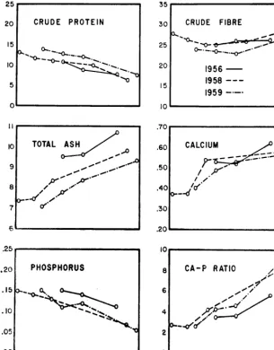
This paper reports on the char- acteristics of a typical sedge meadow; its growth pattern, chemical composition, forage yields both natural and with fer- tilization and effect of periodical clipping during the grazing sea- son from 1956 to 1959. It also re- ports animal weight gains and
beef production from 1956 to 1962.
The Study Area
An 18-acre meadow on the Tranquille Forest Reserve near Kamloops (Figure 1) was se- lected for study. For many years, before being fenced in 1956 for grazing trials with beef cattle, the meadow had been heavily grazed. It lies at approximately 4800 feet elevation within the Englemann spruce (Picea engel- manni)-alpine fir (Abies lasio- carpa) zone and was selected as typical of a number in the area.
The soil of the meadow is mucky sedge peat, pH 5.5, slightly more humified at a depth of three feet than at the surface. In places near the centre of the area the depth exceeded 20 feet as indicated by pressing a pole of this length into the bog. The topography is slightly con- cave with the centre being 12 to 18 inches lower than the edges.
The meadow was dominated by a uniform, dense stand of sedges (Carex), along with lesser
FIGURE 1. Sedge meadow under study in the spruce-alpine fir zone
_____~
LOUISIANA MARSHES 235
swamps and marshes. Bot. Rev. 18: 413-446.
AND EDWARD S. HATHA- WAY. 1938. Plant communities in the marshlands of southeastern Louisiana. Ecol. Monog. 8: l-56. U. S. DEPT OF AGR. SOIL CONSERVA-
TION SERVICE. 1960. Effects of sa- line water from Hurricane Audrey
on soils and vegetation. Alexan- dria, Louisiana, Special report
(mimeo) .
U. S. DEPT. OF AGR. SOIL CONSERVA- TION SERVICE. 1957. Louisiana gulf coast marsh handbook. Alexan- dria, Louisiana.
U. S. DEPT. OF AGR. SOIL CONSERVA- TION SERVICE. 1959. Louisiana
range handbook, Alexandria, Lou- isiana.
WILLIAMS, ROBERT E. 1952. Levees connecting ridges solve marsh ranchers’ grazing problems. Gulf Coast Cattlemen. 18: 31-32.
1952. Walkways improve grazing distribution. Jour. of Soil and Water Cons. 7: 125-126.
Growth, Productivity and Chemical
Composition of a Sub-Alpine Meadow
in Interior British Columbia
ALASTAIR MCLEAN, H. H. NICHOLSONl, AND A. L. VAN RYSWYK
Ecologist, Animal Scientist, and Soil Specialist, respec- tively, Canada Department of Agriculture, Research Station, Kamloops, B. C.
The spruce-alpine fir zone is an important summer grazing re- gion in the interior of British Columbia (Spilsbury and Tis- dale, 1944; Tisdale, 1950) i Graz-
ing is, however, confined largely to the numerous wet meadows and park-like openings in the forest. The meadows are often extensive and furnish large amounts of moderately palatable forage. On the Tranquille range near Kamloops meadows occupy about six percent of the spruce- fir zone; the Cariboo is ten to 70 percent meadow. In the Cariboo district most of the winter feed for livestock is produced on these meadows. They are cut for hay in mid summer and then grazed until late fall. Farther south meadows are used largely for. summer grazing.
The meadows are situated in drainage basins and, therefore, flood in spring and early-sum- mer. Many have been made larger by the impounding of water by beavers. They vary greatly in both vegetation and soils. The soils vary from gleyso- lit mineral to muck and peat
1Formerly at Research Station, Kamloops, now Assistant Pro jessor, Animal Science, University of Sas- katchewan, Saskatoon, Sask.
types; some meadows occur as floating peat bogs. Few refer- ences are available on these meadows, their types, charac- teristics, composition and re- sponse to grazing. They were briefly referred to by McLean and Tisdale (1960), who re- ported some chemical analyses of the forage.
This paper reports on the char- acteristics of a typical sedge meadow; its growth pattern, chemical composition, forage yields both natural and with fer- tilization and effect of periodical clipping during the grazing sea- son from 1956 to 1959. It also re- ports animal weight gains and
beef production from 1956 to 1962.
The Study Area
An 18-acre meadow on the Tranquille Forest Reserve near Kamloops (Figure 1) was se- lected for study. For many years, before being fenced in 1956 for grazing trials with beef cattle, the meadow had been heavily grazed. It lies at approximately 4800 feet elevation within the Englemann spruce (Picea engel- manni)-alpine fir (Abies lasio- carpa) zone and was selected as typical of a number in the area.
The soil of the meadow is mucky sedge peat, pH 5.5, slightly more humified at a depth of three feet than at the surface. In places near the centre of the area the depth exceeded 20 feet as indicated by pressing a pole of this length into the bog. The topography is slightly con- cave with the centre being 12 to 18 inches lower than the edges.
The meadow was dominated by a uniform, dense stand of sedges (Carex), along with lesser
FIGURE 1. Sedge meadow under study in the spruce-alpine fir zone
_____~