Developing a Pilot Strategic Environmental
Assessment for the Western Gulf of Gdansk
Authors: Lidia Kruk-Dowgiallo
1, Radoslaw Opiola
1and Monika Michalek
1 1 Maritime Institute in Gdansk, PolandBaltSeaPlan Report 11
Project part-financed by the European Union (European Regional Development Fund)
IMPRINT
Authors
Lidia Kruk-Dowgiallo, Radoslaw Opiola and Monika Michalek Maritime Institute in Gdansk, Poland
Lead Partner Dr. Nico Nolte
Bundesamt für Seeschifffahrt und Hydrographie (BSH) Bernhard-Nocht-Str. 78, 20359 Hamburg, Germany Tel. +49 (40) 3190-3520
Fax.+49 (40) 3190-5000 [email protected] www.bsh.de
External Project Coordination Office Angela Schultz-Zehden
s.Pro – sustainable projects GmbH Rheinstraße 34, 12161 Berlin, Germany Tel. +49 (30) 8321417-43 Fax.+49 (30) 8321417-50 [email protected] www.sustainable-projects.eu Gdansk – December, 2011
www.baltseaplan.eu
This report has been produced with the assistance of the European Union. Its content is the sole responsibility of the Authors and can in no way be taken to reflect the views of the European Union.
Cover photos: Joanna Przedrzymirska, The Maritime Institute in Gdansk; Karsten Dahl, Department of Bioscience, Aarhus University
Content
CONTENT
1. Introduction ... 2
2. The Pilot Plan ... 3
3. The SEA ... 4
4. Recommendations of SEA report ... 9
5. The stakeholder participation process ... 10
1. Introduction
1. Introduction
The main aim of this Strategic Environmental Impact Assessment (called in the following text SEA) was to identify and to judge potential significant effects of implementation of the provisions proposed in the Pilot draft spatial plan for the Western Part of the Gulf of Gdansk1 (called shortly “the Plan” in the following text) on the environment and objectives and subjects being under protection of the Natura 2000 areas located within the Plan’s boundaries.
Because the Plan is not a formal spatial plan, the whole required by the law SEA procedure was not carried out. Within the BaltSeaPlan project the SEA report was elaborated.
This is the first such kind of document for a maritime spatial plan in Poland. It has been prepared by an interdisciplinary team of specialists from the Department of Aquatic Ecology and the Department of Operational Oceanography of the Maritime Institute in Gdansk, in cooperation with the Maritime Office in Gdynia.
The scope of the SEA report was consistent with national and international regulations concerning Strategic Environmental Assessment, also other environmental documents have been taken into account.
It has been also consulted with the competent authorities (the Regional Director for Environmental Protection in Gdansk and with the Voivodship Sanitary Inspector in Gdansk).
The terrestrial methods have been examined and then adapted to the marine conditions. Descriptive methods, qualitative analyses of the components of the natural environment have been used. A heuristic method of identification of the potential impacts was applied. The assessment of the current state of environment and main environmental problems in the area covered by the Plan was based on the available publications, the expert knowledge and experience.
The carried out analysis was performed for a predetermined time horizon, and is based on rational scientific premises.
From the point of view of the function of the SEA report, the crucial issue was to define the significant negative impacts of the Plan. This process was divided into 3 phases: determination, analysis, and assessment. It was important to pay due attention to the existence of the Natura 2000 areas: Special Area of Conservation Puck Bay and Hel Peninsula, and Special Protection Area Puck Bay.
1 The Pilot draft plan was developed within the InterregIIIB/CADSES project PlanCoast. Its full text and maps in
Polish are available on the website of the Maritime Office in Gdynia at www.umgdy.gov.pl/pium/ogloszenia/podglad?kod=30vy80ido2.uamzqmido1&typ=o from where the text, maps, and study of conditions may be downloaded. A book in English describing the Plan and planning methodology used for its development is available on the website of the Maritime Institute in Gdansk under www.imgda.pl/wydawnictwa
2. The Pilot Plan
2. The Pilot Plan
The area, for which the Plan and the SEA report were developed, covers the space of the Gulf of Gdansk (waters and seafloor) west of the line connecting the tip of the Hel Peninsula and the boundary between the municipalities of Gdynia and Sopot, and includes the inner Puck Bay (called the Puck Lagoon) and the outer Puck Bay. Closed by breakwaters spaces of ports in Gdynia, Puck, Jastarnia and Hel are excluded from the Plan area. To the west and north the Plan area is bordered by the coastline. The Plan covers exclusively the marine space, the area of which is ca. 405.5 km2.
The Plan was prepared to fulfil the following main objectives: > to facilitate sustainable development of the coastal population; > to ensure good state of marine and coastal (land/sea) ecosystems; > to ensure safe and sustainable use of the sea;
> to ensure economical use of sea space, leaving possibly much space for future, also yet unknown, ways of using the sea;
> to ensure proper protection of historical heritage;
> wherever possible, to use of solutions concerning not only space but also time (i.e. the 4D space). The Plan decides on:
> the designation of the marine area/space covered by the plan (economic activities but also environmental protection and natural heritage protection)
> prohibitions or limitations concerning the use of these areas, taking into account requirements of nature conservation;
> the distribution of public importance investments;
> general directions of development of transport and technical infrastructure in the area;
It is important to stress that to a large extent the Plan sanctioned activities already existing in the area.
The Plan includes a textual and a graphic part. The text contains determinations on the principles of management and use of the distinguished 30 “sea basins” and 96 sub-‐basins. It also contains an extensive justification, which includes a description of the existing state of the planned area, a characteristic of conditions for its development and an explanation of the planistic solutions of the Plan. The graphic part is formed by 1:25,000 maps in the “92” national system of coordinates, which can be easily transformed into the system used for sea charts.
3. The SEA
3. The SEA
2Analysis of the Plan’s provisions showed that its objectives are in line with current legislation in Poland and other documents determining the widely understood ecological policy both at national and international level. It should be especially stressed that the objectives of this document are conformant with the most important priorities of the “National ecological policy 2009-‐2012 with outlook until 2016”, i.e. with actions directed at realising the principle of sustainable development and protection of biological diversity. They are also consistent with the EU priorities concerning environmental protection in the period 2002-‐2012 defined in the VIth Programme, especially in relation to marine environment protection.
Established at higher level, principles and tasks concerning environmental protection were taken into account during preparation of the Plan in many ways. The Plan contains recommendations on prioritisation of distinguished sea basins from the point of view of protection, threats, potential conflicts, possible coexistence of nature conservation and economical development. Cohesion of strategic objectives has been initiated already at the stage of formulating the general aim of the draft plan. This aim is understood as: development of acceptable for all stakeholders solutions, ensuring both nature protection and sustainable development, improving living conditions for the coastal communities, ensuring their sustainable development, ensuring good state of marine and land-‐sea ecosystems, safe and sustainable use of marine resources and conservation of historical heritage.
The area covered by the Plan is unique in the scale of Polish sea waters. Its natural values result from the diverse taxonomic composition of macrophytes, forming multi-‐species underwater meadows, and from the rich species composition of ichthyofauna and benthic macro-‐invertebrates. Diversification of habitat conditions and favourable climatic conditions cause that the area of the Plan is also very important due to the rich composition of avifauna species. Occurrence of two species of marine mammals has been noted. However, in spite of it’s natural values, assessment of the ecological status of the area, regarding Biological Quality Elements – phytoplankton, macrophytes and macroinvertebrates as required by EU Water Framework Directive showed that the state of the area is bad.
There are three protected areas in the west part of the Gulf of Gdansk covered by the pilot plan: > Natura 2000 – Special Protection Area “Puck Bay”,
> Natura 2000 – Special Area of Conservation “Puck Bay and Hel Peninsula”, > Coastal Landscape Park.
all of which function without management plans.
If the Plan would not be adopted, then the most important effect would be a lack of coordination of future economical projects and resulting in negative impacts on the state of environment, and also appearance of new risks in the Bay area, such as:
> physical destroying of habitats and disturbance of animals due to uncontrolled touristic pressure in locations with high natural values,
> initiation of negative hydromorphological processes and disturbance of functioning of coastal ecosystems, gradual disappearance of beaches;
> disturbing of animals in their habitats, including spawning and feeding grounds, and deterioration of sea bottom habitats during investment actions;
> deterioration of the quality of landscape;
> degradation of environment in areas of potential sand mining which have high natural value, danger to the stability of the Seagull Bank (Rybitwia Mielizna) habitat.
2 The full text of the draft SEA Report (in Polish) is available on the website of the Maritime Office in Gdynia at
www.umgdy.gov.pl/UserFiles/File/Prognoza oddzialywaniana srodowisko.pdf. It is planned to publish, at the break of 2011 and 2012, the SEA Report, including explanation of methodology, in book form in Polish. Later the book will be also translated to English.
3. The SEA A significant problem, in the context of threats to the natural environment in the area of the Plan, is the lack of effective legal regulations on management and protection of marine nature: lack of uniform management of the protected areas, lack of management plans and inconsistencies of regulations concerning land and sea. Significant threats to most species and habitats in the western part of the Gulf of Gdansk result from the anthropogenic pressure, adverse influence of land-‐based sources of pollution, lack of a comprehensive programme for minimising the effects of these influences and high eutrophication of that water area. Since several years these threats are aggravated by the dynamic development of tourism and recreation, while the capacity of this water area to accommodate such activities without endangering its natural values remains still undefined.
The following assumptions were made at the start of work on the prediction of significant negative impacts: > each undertaking (investment action), realised in the framework of actions stipulated by the Plan, shall
require an EIA procedure, since the whole area of the Plan is in the Natura 2000 network,
> undertakings realised in the future in the Plan area, which may affect the environment significantly, shall require additional impact assessment procedure and shall be subject to obtaining a “decision on environmental conditions of agreement for their realisation”,
> unless no significant impact of an undertaking will be proven within the EIA procedure, or if such an impact is determined and mitigating or minimising actions will prove insufficient, or if proposed compensation actions will not balance the resultant losses in environment, undertakings listed in the Plan shall not be allowed,
> presently planned or realised non-‐investment actions are sanctioned by separate regulations, specific for the given type of activity (e.g. concerning fishery), which take into account environmental protection, > management plans for Natura 2000 areas, when finally developed and implemented, shall ensure
effective protection of the subjects for which these areas were established,
> the protection plan for the Coastal Landscape Park, when finally developed and implemented, shall ensure effective protection of the values of the Park’s area because of which it has been established. As it is known, the main aim of the SEA report is to identify and assess the potential significant impacts of the provisions proposed in the Plan on environment and Natura 2000 areas. Firstly 18 different activities, regulated by the Plan’s solutions, were distinguished and divided into 5 groups:
1. activities resulting in deterioration of the seabed or coastal zone (reclamation of the dredging pits, dredging, dumping, sand mining, nourishment from the sea side and from the land side, permanent coastal defence structures),
2. fishery related activities (fishing with gillnets, fishing using other fishing gears, navigation of fishing vessels),
3. tourism, recreation and transport related activities (regular shipping, motorboat traffic, commercial vessel traffic, bathing areas),
4. activities connected with construction and exploitation of infrastructure (linear infrastructure, point infrastructure),
5. activities connected with national defence – military (navy traffic, closed areas).
The provisions of the Plan were assessed from the point of view of the impact of presently realised and future activities. The assessment was carried out with respect to the impact on a given element in the scale of the whole area of the Plan, with special attention given to these sea basins, in which the activities are to be realised.
In the second stage analyses were carried out and calculation and description matrices were developed. For each source of impact, potential significant effects were listed including concrete name of the sea basin and with calculation of the sea area or length of coastline affected (table 1). Then the activities with potential environmental impact were shown graphically on maps (Figure 1). The solutions of the Plan were also analysed with view on the reduction of negative environmental impacts.
3. The SEA
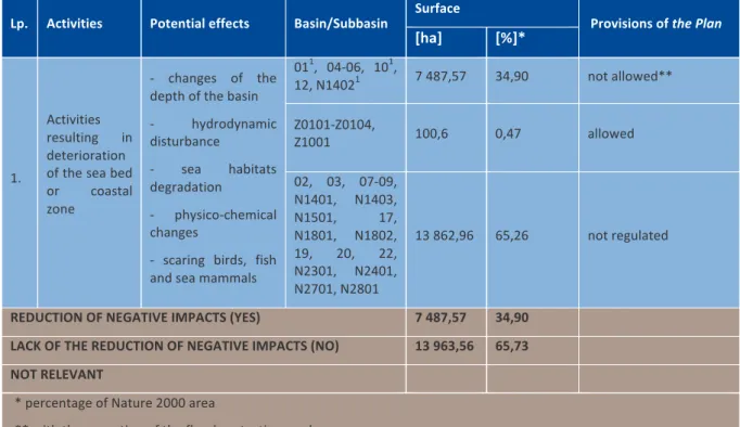
Table 1 Example of the description matrix for the selected impact source (i.e. activities resulting in deterioration of the sea bed or coastal zone)
Lp. Activities Potential effects Basin/Subbasin Surface Provisions of the Plan
[ha] [%]*
1.
Activities resulting in deterioration of the sea bed or coastal zone
-‐ changes of the depth of the basin -‐ hydrodynamic disturbance -‐ sea habitats degradation -‐ physico-‐chemical changes
-‐ scaring birds, fish and sea mammals
011, 04-‐06, 101, 12, N14021 7 487,57 34,90 not allowed** Z0101-‐Z0104, Z1001 100,6 0,47 allowed 02, 03, 07-‐09, N1401, N1403, N1501, 17, N1801, N1802, 19, 20, 22, N2301, N2401, N2701, N2801 13 862,96 65,26 not regulated
REDUCTION OF NEGATIVE IMPACTS (YES) 7 487,57 34,90
LACK OF THE REDUCTION OF NEGATIVE IMPACTS (NO) 13 963,56 65,73
NOT RELEVANT * percentage of Nature 2000 area
** with the exception of the flood protection works 1 on the part of the subbasin
3. The SEA
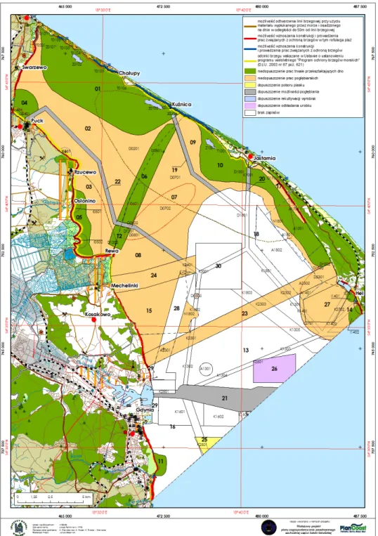
Figure 1 Example of a map
Thanks to the adopted comprehensive approach, information about the surface of areas under threat of significant impact was obtained, and about the percentage of such impacted areas in the protected areas (habitat and bird protection) located within the Plan boundaries.
In the third stage the assessment was carried out. The typology of each impact was defined in agreement with the EIA Directive. Impacts were been divided according to three criteria: direction of influence (positive, negative), type of relation to the influenced object (direct, indirect, cumulated) and the time (intensity) of influence (short term, medium term and long term, permanent The impact of each of the activities, defined at the start of the analysis, on all components of the environment was assessed.
For each object the impact from each source was described and classified accordingly and separately. Next, all the partial assessments were summed up, and on this basis it was determined that the most negative cumulated impacts will occur in case of implementation of coastal defence related actions. This is due to the durability of such actions, physical interference into bottom habitats, and the relatively large lengths of coastline along which such actions are to be carried out.
3. The SEA
Animals are probably the most threatened components of the environment, since nearly all activities defined in the Plan exert an influence on them. This is also because of their massive occurrence and considerable number of species (birds, fish, sea mammals, benthic organisms).
Activities, which could in any way influence the climate, positively or negatively, are not allowed in the area of the Plan.
With respect to the objectives and subjects being under protection of Natura 2000 areas, the most acute impacts are exerted by permanent coastal defence structures.
Assessment of the cumulative effects of environmental impacts of the Plan’s solutions, in the six main groups describing the character of functioning of the area, such as: transport accessibility, national defence, economical activities, protection of people and property on land, nature protection, protection of cultural and material heritage, showed that in three cases economical activities can strengthen negative environmental impacts, when it is connected with:
> transport accessibility, > national defence,
> protection of people and property on land.
The strength of this cumulative effect will depend on the intensity of the realised activities, their location and duration.
With the exception of the planned construction of a system for gas reception and transmission, including a CNG terminal, no transborder impact of activities allowed in the Plan was identified. This project would result in increased ship traffic (also outside the area of the Plan and outside the Polish seawaters.
The SEA report proposes solutions to mitigate negative environmental impacts of activities allowed by the Plan: existing dredging pits, dumping, sand extraction, sand nourishment from the sea side, sand nourishment from the land side, permanent coastal defence, drift nets, other fishing gear, point and linear infrastructure.
No specific form or scope of compensation actions is proposed, since these should be analysed for each investment separately within the permitting procedures.
Spatial solutions proposed in the Plan result in a significant reduction of the potential for conflict between the leading functions in each sea basin and the resulting from national, EU and other international law obligation to protect environment in the Plan area.
The Plan does not introduce new ways of use, but rather sanctions activities already realised in the planned area. For most of these activities there is no real alternative. However the SEA report proposes considering alternatives to five provisions of the Plan concerning: dumping, sand extraction, coastal protection activities, bathing areas and infrastructure in sea basins No. 24 and 30.
In the light of current knowledge, it seems that the provisions of the Plan are optimal. It is however highly probable that in the course of the multiannual process of implementation of the Plan, and with the development of knowledge, the solutions will have to be corrected. Three groups of actions are proposed in order to monitor the effects of the Plan implementation:
> control, by the Maritime Office in Gdynia, of the implementation of provisions concerning the location of investments and of ways in which space is used;
> assessing , whether the desired state of environment is achieved (ecological status assessment based on biotic elements of the environment)
> analysis of changes of socio-‐economic indicators.
The actions, which may significantly deteriorate the state of natural habitats in Natura 2000 areas, are prohibited. Limitations are put on tourism, fishery and investment related actions.
The authors of the Plan made some mistakes, which are listed in the SEA report. They result mostly from the comprehensiveness of the Plan, and, in character, they are rather minor defects and inaccuracies such as e.g.: inconsistency of the general solutions of the Plan with detailed solutions in the sheets of some sea basins, ambiguity of detailed solutions in the sheets of some sea basins, or allowing mutually excluding activities in the same sea basin. However, they do not have a basic influence on the achievement of the objectives of the Plan. Introducing into it the proposed additional solutions and corrections should improve the cohesiveness and clarity of the document.
4. Recommendation of SEA report
4. Recommendations of SEA report
Finally, 7 recommendations are given in the SEA report:
1. The solutions of the future Spatial Plan for the Western Part of the Gulf of Gdansk should be corrected and supplemented basing on the above-‐mentioned list given in the Report. They should also take into account the extension of the Natura 2000 habitat protection area “Puck Bay and Hel Peninsula” and establishment of a new protected area for the Orłowo cliff.
2. Coastal defence activities, especially permanent revetments, should not be allowed in locations where their negative impact on habitats protected within the Natura 2000 network could result in their deterioration or disappearance.
3. In the future, when it is intended to produce a maritime spatial plan, within the area of which are located protected areas, firstly managament plans for such areas should be elaborated, and maritime spatial plans should take into consideration the requirements of these documents. Such a sequence is substantiated both by meritoric and methodological reasons since it allows to arrive at better solutions for non-‐conflicting coexistence and co-‐functioning of nature conservation and economical activities. This is especially important in cases where economical activities are to be realised in Natura 2000 areas, in which only specified habitats and species are protected. This sequence is also determined by the character of the protected areas, which should form a spatial network, in which the connecting ecological corridors should also be included. These corridors are equally important for nature protection as the protected areas themselves.
4. While acknowledging the high methodological value and pilot character of the Plan, it is suggested that in the future the area, for which a maritime spatial plan will be developed, should include the full extent of areas being under various forms of protection, especially the Natura 2000 areas. An optimum solution would be to develop maritime spatial plans for larger geographical “units” (e.g. the whole Gulf of Gdansk from Rozewie to the boundary of the EEZ on the east side). Only then the SEA will be able to produce a comprehensive assessment of potential negative impacts on all components of environment (the present SEA was not able to assess appropriately the impact of the Plan on the integrity of the Natura 2000 bird protection area),. Transborder procedures will be effectively facilitated because it will be possible to take proper account of geographically distant economical activities with potentially negative impacts on the objectives and subjects of protection in the Natura 2000 areas.
5. Legislation on maritime spatial planning should be amended to contain regulations requiring the Directors of Maritime Offices to update MSPs in accordance with new environmental information and changes of law.
6. Technical activities concerning coastal protection should be realised in accordance with the principles and guidelines of the “Coastal Protection Strategy”. In the Strategy, the option of selective and active coastal protection is adopted for each scenario of sea level rise, since such approach to coastal protection is considered as best economically and technically justified for the Polish coast. The Strategy assumes that some selected stretches of the coast will be intensely protected, acting as durable “headlands” stabilising the whole Polish coastline. The Strategy assumes also that the most threatened (vulnerable) by sea level rise are coasts with highly invested hinterland and/or with natural values unique in European and national scale.
7. Indication of stretches of coast, along which coastal protection measures are to be implemented, should be preceded by an up to date assessment of the state of the coastal zone including valuation of the natural and anthropogenic coastal environment. Such an assessment requires that a holistic monitoring programme is implemented. At present monitoring covers only the morphology of the coastal zone.
5. The stakeholder participation process
5. The stakeholder participation process
Already in 2007, when the Pilot Spatial Plan for the Western Part of the Gulf of Gdansk was being drafted within the PlanCoast project, the Maritime Office in Gdynia made known to all potentially interested parties that though this will not be a legally binding formal spatial plan, it shall be used for real life decision making as a synthesis of best available knowledge. Probably this was the main reason of the very extensive and active participation of stakeholders in the Plan preparation and consultation processes. The list of active stakeholders included various national, regional and local authorities, business, research institutions and NGOs.
The same approach was adopted for the SEA. Over 100 parties were informed in writing that the SEA consultation process is starting and that proposals and remarks on the draft SEA report are welcome. The same information was placed on the websites of the Maritime Office in Gdynia and the Maritime Institute in Gdansk. Also consecutive drafts of the SEA report and the full documentation of the Plan were placed on both websites. In the first stage of the consultation process 109 comments were received, in the second – 49. Two meetings with stakeholders were organised by the Maritime Office with a participation of over 80 people. The meetings were given to the explanation of the rather novel concept of an SEA for a maritime spatial plan, to the presentation of the reservations and to discussion of the received suggestions.
A significant number of reservations concerned rather the Plan than the SEA report. Basing on the pertinent comments, and discussion during the stakeholder meetings, the final version of the SEA report was prepared and then placed on the website of the Maritime Office in Gdynia.
6. Further steps
6. Further steps
As earlier mentioned (see footnote 2), the SEA report, together with an extensive discussion on methodology, shall be published in book form. Also an English translation of the book is anticipated.
Both the Plan, developed within the PlanCoast project, and in consequence the present SEA Report, are informal documents. It is planned to develop a formal maritime spatial plan for the same area (or maybe covering the whole area of the internal sea waters of the Gulf of Gdansk) and corresponding SEA after the protection plans for the Natura 2000 sites located in the Gulf will be adopted, which is planned for 2014. Until that time the Plan and the SEA report will remain an important basis for decision making on issues related to the use of space in the Plan area and its direct vicinity.
Both the pilot Plan and pilot SEA report will be the basis for the formal documents, significantly facilitating the process of their development.
Germany
• Federal Maritime and Hydrographic Agency (BSH), Lead Partner
• Ministry of Energy, Infrastructure and Regional Development of Mecklenburg-Vorpommern • WWF Germany, Baltic Sea Unit
Poland
• Maritime Office in Szczecin • Maritime Office in Gdynia • Maritime Institute in Gdańsk Denmark
• Department of Bioscience, Aarhus University (formerly National Environmental Research Institute – NERI) Sweden
• Royal Institute of Technology (KTH) • Swedish Environmental Protection Agency Estonia
• Estonian Marine Institute of University of Tartu • Baltic Environmental Forum Estonia
Lithuania
• Klaipėda University Coastal Research and Planning Institute (CORPI)
• Baltic Environmental Forum Lithuania Latvia
• Baltic Environmental Forum Latvia
Partners
The BaltSeaPlan
project in general
Activities
BaltSeaPlan activities were designed to support all major aspects of maritime spatial planning within the Baltic Sea region:
> Improving the joint information base / stocktaking for maritime spatial planning:
A forum for dialogue bringing together spatial planners and scientists and identify sources of data / information. Compiling current uses, conflicts and natural values of the Baltic Sea. Filling data gaps, exchange of data, im-prove integration of ecological and socio-economic data sets, identify relevant modelling methods, clarify MSP data needs.
>Including Spatial Planning in National Maritime Strategies
Assessment of national frameworks, methodologies and sectoral strategies that influence the use of sea space (e.g. energy, fishery, transport, tourism, as well as na-ture conservation)
Developing recommendations on spatial issues within National Maritime Strategies.
Exploiting the visions to foster a national cross-sectoral debate, discussing goals & targets for dealing with space and filling gaps in national sectoral policies & strategies
> Develop a Vision for Maritime Spatial Planning in the Baltic Sea 2030
taking into account transnational interdependencies and cumulative impacts
initiate a Baltic Sea region wide campaign as to discuss the BaltSeaPlan Vision 2030
> Demonstrate MSP in 8 pilot areas
• Danish Straights / T-Route (DK) • Pomeranian Bight (DE/DK/SE/PL) • Western Gulf of Gdansk (PL) • Middle Bank (SE/PL) • Lithuanian Sea (LT) • Latvian Sea (LV) • Pärnu Bay (EE)
• Hiiumaa and Saaremaa Islands (EE)
> Lobbying and capacity building for MSP
• stakeholder involvement & participative planning methods
• BaltSeaPlan series of guidelines & policy recommen-dations
BaltSeaPlan Publications
• BaltSeaPlan Findings• BaltSeaPlan Vision 2030 – Towards the sustainable planning of Baltic Sea space
• Become a Maritime Spatialist within 10 Minutes (EN, DE, LV, LT, PL, EE)
• BaltSeaPlan Bulletin #1
• BaltSeaPlan Bulletin #2
• BaltSeaPlan Project Flyer (EN, DE, LV, LT, PL, EE, SE)
Impact Assessments
1 - Strategies with relevance for Estonian maritime space
2 - Strategies with relevance for German maritime space
3 - Strategies with relevance for Latvian maritime space
4 - Strategies with relevance for Lithuanian maritime space
5 - Strategies with relevance for Polish maritime space
6 - Strategies with relevance for Russian maritime space
7 - Strategies with relevance for Swedish maritime space
8 - Implications of the international and national policy context
for Baltic Sea space and MSP
Pilot MSP reports
9 - Developing a Pilot MSP for the Pomeranian Bight and
Arkona Basin
10 - Developing a Pilot MSP for the Middle Bank
11 - Developing a Pilot SEA for the Western Gulf of Gdansk
12 - Preparing for a MSP at the Danish Straits
13 - Towards a Pilot MSP for the Pärnu Bay
14 - Towards a Pilot MSP for the Saaremaa and Hiiumaa Islands
15 - Towards a Pilot MSP for the Lithuanian Sea
16 - Developing a Pilot MSP for the Western Coast of Latvia
MSPs and SEA
17 - Pilot MSP for the Western Coast of Latvia (LV)
18 - SEA for the Western Gulf of Gdansk (PL)
Technical reports
19 - Modelling for MSP – Tools, concepts, applications
20 - Data exchange structure for MSP
21 - Effects of underwater noise on harbour porpoises around
major shipping lanes
22 - Remote sensing methods for detecting small fishing vessels
and fishing gear
23 - Legal and planning options for integrating fisheries into
Maritime Spatial Planning
24 - Stakeholder Involvement in MSP
25 - SEA in MSP: Recommendations from the German and Polish
experience
26 - Fisheries in the MSP context
27 - Seabed and habitat mapping in the Hatter Barn area
28 - BaltSeaPlan Web-advanced tool in support of MSP
29 - Case Study: Systematic site selection for offshore windpower
with Marxan in the pilot area Pomeranian Bight
30 - Case Study: Site selection of fisheries areas for MSP
31 - Recommendations for legislative action regarding the MSP in
Maritime Spatial Planning (MSP) has become a widely acknowledged and necessary tool for co-ordinating spatial use and balancing of interests in the sea. In view of expanding activities such as offshore wind energy parks and growing shipping traffic and at the same time increasing needs to protect the marine environment a systematic, integrative and forward-looking planning is required in order to safeguard the sustainable development of the seas. Currently, however, this tool is far from being established practice.
The 3.7 million € INTERREG IVB project “BaltSeaPlan” (2009–2012) has been the largest project in recent years dealing with maritime spatial planning throughout the Baltic Sea Region. Under the lead of the German Federal Maritime and Hydro-graphic Agency (BSH) and covering partners from all Baltic Sea countries (except Finland) the project has not only developed pilots in 8 demonstration areas, but also advanced methods, instruments & tools as well as data exchange necessary for an effective maritime spatial planning.
The results of BaltSeaPlan are published in a series of reports all available for free download under www.baltseaplan.eu.
As a pilot project on MSP in Poland a “Draft Spatial Plan for the Western Part of the Gulf of Gdansk” had been elaborated be-tween 2007–2009 in the framework of the EU funded “PlanCoast” project. The main aim of the Strategic Environmental Impact Assessment was to identify and judge significant effects of the implementation of the provisions proposed under this draft MSP on the environment and objectives / subjects being under protection of Natura 2000 within this planning area. The BaltSeaPlan
Report � 11 “Developing a Pilot Strategic Environmental Assessment for the Western Gulf of Gdansk” provides an English lan-guage summary of the steps applied for the SEA as well as the main findings and recommendations provided within the SEA.
Project part-financed by the European Union