RESEARCH ARTICLE
Adaptive Routing Protocol based on Cuckoo Search
algorithm (ARP-CS) for secured Vehicular Ad hoc
network (VANET)
Dr. B. Ramakrishnan
Associate Professor, Department of Computer Science and Research Centre,
S.T. Hindu College, Nagercoil, Tamilnadu, India.
S. R. Sreedivya
Research Scholar, S.T. Hindu College, Nagercoil, Tamilnadu, India.
M. Selvi
Research Scholar, S.T. Hindu College, Nagercoil, Tamilnadu, India.
Abstract – A wide range of protocols are used to achieve secured message broadcasting in VANET. Most commonly used protocols are topology based routing and geography based routing protocols. In order to overcome the issues of these 2 protocols, we proposed a design of Adaptive routing protocol based on Cuckoo search algorithm (ARP-CS). The adaptive protocol combines the features of both topology routing and geographic routing protocols which ensures the secured transmission of data with less delay and high packet delivery ratio. ARP-CS provides reliable and secure routes between source and destination node with optimal distance and low routing overheads. ARP-CS uses a local stochastic broadcasting to find routes which reduces the network congestion thereby improving the packet delivery ratio.
Index Terms – VANET, AODV, GPRS, routing protocol, cuckoo search.
1. INTRODUCTION
To improve road safety by granting timely and precise information to drivers and authorities and due to the rising interests in Vehicular Ad hoc Networks (VANETs) over the last decade have led to vast investments in technologies and research. The reliable message routing from a source node to a destination node is one of the most significant characteristics that establish the success of VANET [1]. In VANET routing relies on the existence of a sufficient number of VANET nodes that represent well-built paths to permit the forwarding of messages in the network. These paths can be made unsustainable and unreliable when exaggerated by the vehicles’ traffic density and mobility, frequent network topology changes [2]. Due to the high mobility and wide range of vehicles, offering security in a vehicular network is tricky than in other networks such as WSN. However as per the trend of today security issues such as localization, confidentiality, non-repudiation, authentication, and verification of data are
still the most significant trouble to be resolved that affects the quality of service (QoS) in VANET [3].
Providing many applications like traffic observation, global positioning system, management of traffic and many more, in which VANET is a part of Intelligent Transport System (ITS). To create communication among Vehicle-To-Vehicle (V2V) and Vehicle-To-Infrastructure (V2I) communication, a range of protocols are used [4, 5, 6, 7].Various protocols are used to establish communication between Vehicle-To-Vehicle (V2V) and Vehicle-To-Infrastructure (V2I) communication [4, 5, 6, 7].
Leading to developments on various issues like road safety or infotainment innovative applications and services can be given to the vehicle, where one of the key areas to relate these developments is driving assistance [8, 9]. To help the driver build appropriate decisions, receiving data to the traffic status can be referred; this allows the driver to know well about the current circumstance as knowledge is not limited to what is on field of vision. Also in cases such as a bottleneck or a slippery road, vehicular emergency warning systems cooperatively talk with each other when they sense a hazardous event. Primarily by using the on-board component known as On-Board Unit (OBU) [10], whenever a potential warning road condition is found this warning message system produces a new message and broadcasts it further than the instantaneous transmission range. However the received data must precisely reflect the road traffic status as the received data can affect the driving task so they should be trustworthy [11].
RESEARCH ARTICLE
produced. By means of esteem to the transmission, message routing in VANET, it also permits the intermediary nodes to influence the dispatch data [12]. Ultimately if they are not executed in a HSM the storage and evaluation phases can as well be attacked, with the effect of storing fake data or reaching a wrong termination from data evaluation [13].
2. LITERATURE SURVEY
Mohammad Al-Rabayah and Robert Malaney [14] have proposed a hybrid location-based routing protocol that is particularly designed to address the issue. Their protocol merged the location based routing information. They provided the Location enabled pragmatic solution to VANET. From the simulation results we observed the scalable and optimal overhead.
Josiane Nzouonta [13] et al. have designed and implemented a reactive protocol RBVT-R and a proactive protocol RBVT-P. From the simulation results we observed that its average delivery rate increases 40% and average delay decreases 85% when compared to the existing works.
Kaveh shafiee and Victor C. M. Leung [15] have proposed a protocol for VANET in which they will change the status of the network based on geographic routing. The protocol CMGR determined the routes with minimum delay. From the simulation results, their technique out performs the existing routing protocols A-Star, and VADD.
3. PROBLEM DEFINITION
The drawbacks of topology-based and geography-based routing protocols when applied to VANETs are summarized in this section. The main drawback of topology-based routing protocols is their route instability. This is because an established route consists of a set of nodes between the source and the destination that are affected by frequent broken routes in the presence of high vehicle mobility.
To discover the path in the network, hello messages are used and this will leads a high routing overhead. This is the major overhead. When the network density is low, the route discovery causes the high latency and transmission delay which is a limitation in topology based routing protocol. Consequently, an update of the discovered routes is required which causes an important delay.
On the other hand, despite the stability of the discovered routes, geography-based routing protocols suffer from several serious drawbacks. The first drawback is the difficulty in finding an optimal next hop node when searching the destination node, especially in the city-based scenario. As an alternate of selecting the shortest path for route discovery geography based routing protocols uses longest path in terms of geographic distances which is the disadvantage.
The second drawback results when the recovery strategies of the geography-based routing are applied. As we mentioned previously the recovery strategies are based on planar graph traversals which often require no cross-links in order to recover routes. This requirement is hard to achieve in practice for VANETs because of the presence of radio obstacles and the high mobility of vehicles to ensure there are no intersections between links. This can be easier in an environment characterized by a uniformly distributed instead of the planar graphs. The third disadvantage of geography-based routing protocols is the inherent loops caused by the vehicle’s mobility and its strict positions when discovering or maintaining routes. These loops can lead to loss of the ability to memorize past traffic history which can help to prevent launching a new routes discovery.
4. PROPOSED METHODOLOGY
To decrease the routing overheads frequently incurred by traditional routing protocols, ARP-CS disseminates the transmitted packets in a stochastic manner. In addition, it uses multiple paths simultaneously between the source and the destination to send packets in order to reduce the transmission time (end-to-end delay), to decrease routing overhead and to increase packet delivery ratio. Consequently, the proposed part guarantees data transmissions in real time to help drivers make safe decisions and to improve road safety.
RESEARCH ARTICLE
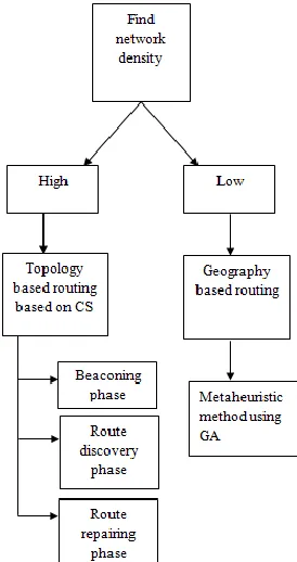
As mentioned above, hybrid technique Adaptive Routing Protocol based on Cuckoo Search algorithm (ARP-CS) which applies a topology-based routing approach when the network density is high (e.g., city-based VANET) and applies a geography-based routing approach when the network is not dense (e.g., highways) as shown in Figure 1.
In VANET, the position of the node, the route towards the source and destination and topology details are stored in the routing table which dynamically updated when the routes changed.
4.1.Topology based routing based on Cuckoo Search algorithm
Topology-based routing is a reactive routing method that is applied if the network is highly dense. This procedure consists of three phases: (a) the beaconing phase which ensures the local updating of the node links in its transmission range of the current node, (b) the route discovery phase used to find different routes from the source to the destination, and (c) the route repairing phase which is performed when the links are broken.
4.1.1. Beaconing phase
This phase is carried out by each node in the VANET environment and aims to inform the node of its neighbours and update its active links. This phase also helps to estimate the road safety requirements such as the available bandwidth and the measured end-to- end delay of each link. In their transmission range, most of the nodes intermittently transmit the packets. When a neighbour node receives the beacon packet, all entries in its routing table about the sender will be considered as valid. The routing information in the routing table is marked as invalid if a node does not get information from the node’s neighbour for a specified amount of time. Consequently, the other nodes are informed of this unavailable link using an error packet.
4.1.2. Route discovery phase
When one node is responsible to transmit data, it first checks whether the route is present in its routing table and the road safety requirements are satisfied. In other words, the required bandwidth and delay in the proposed route should be less than the available bandwidth and the actual delay respectively. If there are sufficient forgers, the source node transmits the data, otherwise, data is buffered until new foragers are recruited.
To discover a route, the source node generates and clones several forward scouts to be launched and broadcasted stochastically to their immediate neighbours. As an experimental value, we have fixed the threshold for the number of neighbours to 80% because it leads to optimal results. All cloned forward scouts share the same scout identifier, the beehive identifier, the food identifier and the maximum
lifespan of the route request. The hop count of a forward scout is initialized to zero and is increased every time it encounters a node until it reaches the destination. Whenever the forward scout encounters a node, the cumulative travel time is saved in the timestamp field.
The visited node checks the road safety requirements followed by the route discovery process. Otherwise the forward scout will be dropped and the route discovery process is not executed. At the same time, each intermediate node checks if it has already received a forward scout with the same scout identifier and beehive identifier. If so, the forward scout will be dropped, else the node saves the forward scout identifier and the source node identifier at the prior hop field in the routing table entry. This saved data keep track of the visited node about the identity of the last (newer) forward scout. This step prevents further consideration of the same scout or of an old one. Afterwards, the route existence is checked with the intermediate node’s routing table. If the intermediate node does not know the route to the destination; it clones and rebroadcasts stochastically the forward scout like the source node. However, if the route is discovered in the routing table of this intermediate node, it generates and launches a backward scout to the source node along the reverse path using the prior hop field located in the routing table.
4.2. Cuckoo search based route discovery process
The route discovery can be done by cuckoo search algorithm. Now, an adapted cuckoo search algorithm called S-Cuckoo is employed to calculate the best route. The detailed clarification of selection process is offered in subsections.
4.2.1. Initialization
At first,
N
number of solutions or nests is randomly generated in the initialization process. The initialization process of nest is illustrated in table 3. Here, “0” and “1” are randomly initialized for each nest.4.2.2. Fitness selection
The selection of the fitness is a crucial aspect in cuckoo search algorithm. It is used to evaluate the aptitude (goodness) of candidate solutions. Here, minimum distance is selected as the best fitness to find the optimal route. To evaluate an individual, an objective function (i.e., fitness function) is applied that considers the shortest path from the source to the destination as the best one. In other words, the fitness fi of the individual ‘i’ is the sum of the distance (dis) between each two adjacent nodes ‘nj’ and ‘nj+1’ in the path from the source node ‘s’ to the destination node ‘d’, calculated by the following formula:
ds
j j j k
n
dis
n
n
nest
RESEARCH ARTICLE
4.2.3. New solution generation using Levy flight
To generate novel solution, levy flight method is applied at this point. It is a type of random walk. It will arbitrarily search for length to produce novel solution which has a heavy-tailed distribution. Levy flight has a huge coverage range in search space.
Both, original and adapted codes employ random step sizes. We employ different function set for computing this step size compared to the original code. In the original code, step size is computed by subsequent code expression:
)
(
*
01
.
0
1 bestt
i
S
S
v
u
stepsize
Where,
0.01 a factor for controlling step size of cuckoo walks/flights,
t i
S
is current solutioni
of iterationt
best
S
is the global best solution
stepsize
is the length of walk step
is entry-wise product
u
andv
are random value
Levy distribution parameterIn order to calculate the step size, in this paper, we modify the equation (5) to improve the fitness performance. The modified step size formula expression is given by:
)
(
*
01
.
0
1t i
best
S
S
v
u
stepsize
Finally, we take step size to generate new solution, where
S
it1is new solution at iteration.
)
1
,
0
(
1
N
stepsize
S
S
it
t
The difference between cuckoo and modified step size cuckoo is that levy flight is used in both cases but step size of levy flight is changed in modified cuckoo. Like this, higher fitness solutions contain small benefit over solutions with lower fitness. At this point, every iteration, worst nests based on the
probability (
p
a) are substituted with a novel set of solutions.The algorithm stops its implementation only if maximum number of iterations is attained and the nest which is containing
the best fitness value is chosen and it is given as best route to route discovery.
4.2.4. Route repairing phase
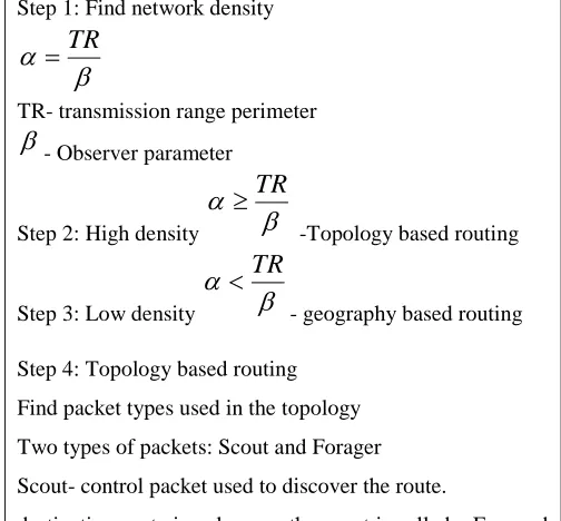
The periodic sending of beacon packets in the transmission range between the node and its neighbours helps to ensure the stability of the connections. If there is connectivity problem, the node detects the broken link and any route passing through this broken link is considered as disconnected. The following Table 1 shows the entire working process of the proposed model.
Step 1: Find network density
TR
TR- transmission range perimeter
- Observer parameterStep 2: High density
TR
-Topology based routing
Step 3: Low density
TR
- geography based routing
Step 4: Topology based routing
Find packet types used in the topology
Two types of packets: Scout and Forager
Scout- control packet used to discover the route.
destination route is unknown, the scout is called a Forward scout
when destination node is found it returns to the beehive as a backward scout to transmit this discovery information to its nest mates
Forager- data packet used to transmit the data between nodes.
Find routing table used in the topology
Three phases of topology
RESEARCH ARTICLE
Step 6: Route discovery phase- When one node is responsible to transmit data, it first checks whether the route is present in its routing table
Step 7: Route repairing phase- When links are broken in VANET, The periodic sending of beacon packets in the transmission range between the node and its neighbours helps to ensure the stability of the connections.
Step 8: Geography based routing
Metaheuristic method is used to find the shortest paths between the source and the destination from the basic entries of the positions table. The metaheuristic method provides the optimal route to use to transmit packets in with the least geometric distance from the source to the destination. Here GA used for the metaheuristic method.
Table 1 Procedure for the entire process
5. RESULTS AND DISCUSSION
The suggested methodology for secured data transaction in a network is executed in Java with user defined network. The proposed methodology has been analysed using three road safety metrics namely: average end-to-end delay, packet delivery ratio, and normalized overload load.
We note that in this work, three sets of experiments have been conducted. In the first one, 15 nodes have been used in the network (corresponding to low density). In the second set of experiments, the network consists of 30 nodes (corresponding to medium density). In the third set of experiments, we considered a network with 45 nodes (corresponding to high density).
Figure 2: Average end-to-end delay
Our simulation results show that proposed method outperforms AODV and GPSR in terms of average end-to-end delay (as shown in Figure 2). It takes 0.07s in the low density case, 0.15s in the medium density case, and 0.26 when the network is highly dense, compared to AODV and GPSR which resulted in 0.22s and 0.90s in their best cases, respectively. HyBR
improves the end-to-end delay from 5% to 61% against AODV, and from 69% to 112% compared to GPSR.
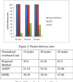
Figure 3 depicts the packet delivery ratio values of the proposed method, AODV and GPRS protocols for various network diversities. The results show a high delivery of packets with HyBR: 99.52% if there are 15 nodes, 97. 8% with 30 nodes and 98.9% when the network is dense which are slightly higher compared to AODV.
Figure 3: Packet delivery ratio
Normalized overhead Load
15 nodes 30 nodes 45 nodes
Proposed
Method
39.6 41.01 61.5
AODV 51.19 55.42 53.88
GPSR 38.39 39.34 47.86
Table 2 Normalized overhead Load
As for the normalized overhead load results obtained in Table 2, we note that proposed method offers acceptable values 39.6%, 41.01% and 61.5% for different network densities. It is worth mentioning that GPSR gives the best results (38.39% to 47.86%) because it does not generate a route request packets and the maintenance mechanism is not used.
6. CONCLUSION
ARP-CS technique guarantees road safety service quality which is the most objective of transportation systems. It uses two main procedures to deal with the varying density of VANET. When the network density is low a geography-based routing approach is performed otherwise, a topology-based routing protocol is executed. It is worth noting that this protocol can apply the two procedures at once based on the network density. Our experimental results show that our proposed method outperforms the exiting routing protocols.
RESEARCH ARTICLE
[1] Josiane Nzouonta, Neeraj Rajgure, Guiling (Grace) Wang, and Cristian Borcea, IEEE TRANSACTIONS ON VEHICULAR TECHNOLOGY, VOL. 58, NO. 7, SEPTEMBER 2009 3609] VANET Routing on City Roads Using Real-Time Vehicular Traffic Information.
[2] Hanan Saleet, Rami Langar, Kshirasagar Naik, Raouf Boutaba, Amiya Nayak, and Nishith Goel IEEE TRANSACTIONS ON VEHICULAR TECHNOLOGY, VOL. 60, NO. 9, NOVEMBER 2011
[3] Jing Zhao, and Guohong Cao.IEEE TRANSACTIONS ON VEHICULAR TECHNOLOGY, VOL. 57, NO. 3, MAY 2008 VADD: Vehicle-Assisted Data Delivery in Vehicular Ad Hoc Networks.
[4] Ming-Chin Chuang and Meng Chang Chan, IEEE transactions on wireless communications, Vol-12..No.10 October 2013.DEEP: Density Aware Emergency Message Extension Protocol for Vanets.
[5] Mohammad Al-Rabayah and Robert Malaney, Member IEEE, IEEE TRANSACTIONS ON VEHICULAR TECHNOLOGY, VOL. 61, NO. 6, JULY 2012 A New Scalable Hybrid Routing Protocol for VANETs. [6] Ramakrishnan, B., Rajesh, D. R., & Shaji, R. S. (2010). An Intelligent
Routing Protocol for Vehicle safety communication in Highway Environments. Journal of computing, 2(11), 2010.
[7] Ramakrishnan, B., R. S. Rajesh, and R. S. Shaji. "Analysis of routing protocols for highway model without using roadside unit and cluster." International Journal of Scientific & Engineering Research 2.1 (2011): 1-9.
[8] Omar Alghushairy, Wael Aljohani, and Majdi Alharthi Department of Computer Science & Engineering, University of Bridgeport, USA. An Efficient Routing Protocol for Connecting Vehicular Networks to the Internet.
[9] Ramakrishan, B., M. Milton Joe, and R. Bhagavath Nishanth. "Modeling and simulation of efficient cluster based Manhattan Mobility model for Vehicular communication." Journal of Emerging Technologies in Web Intelligence 6.2 (2014): 253-261.
[10]Ramakrishnan, B., R. S. Rajesh, and R. S. Shaji. "CBVANET: A cluster based vehicular adhoc network model for simple highway communication."International Journal of Advanced Networking and Applications 2.04 (2010): 755-761.
[11]Sherali Zeadally, Ray Hunt, Yuh-Shyan Chen, Angela Irwin, Aamir Hassan. Vehicular Ad Hoc Networks (VANETS): Status, Results, and Challenges.
[12]Vinod Namboodiri, and Lain Ago, Member, IEEE. IEEE TRANSACTIONS ON VEHICULAR TECHNOLOGY, VOL. 56, NO. 4, JULY 2007.
[13]Josiane Nzouonta, Neeraj Rajgure, Guiling (Grace) Wang, and Cristian Borcea,, IEEE TRANSACTIONS ON VEHICULAR TECHNOLOGY, VOL. 58, NO. 7, SEPTEMBER 2009 3609.
[14]Mohammad Al-Rabayah and Robert Malaney, IEEE TRANSACTIONS ON VEHICULAR TECHNOLOGY, VOL. 61, NO. 6, JULY 2012. [15]Kaveh shafiee, Victor C. M. Leung, "Connectiviry aware minimum delay
geographic routing with vehile tracking in VANETs", Ad Hoc Networks, Vol. 9, pp. 131-141, 2011.
Authors
Dr. B. Ramakrishnan is currently working as Associate Professor in the Department of Computer Science and research Centre in S.T. Hindu College, Nagercoil. He received his M.Sc degree from Madurai Kamaraj University, Madurai and received Mphil (Comp. Sc.) from Alagappa University Karaikudi. He earned his Doctorate degree in the field of Computer Science from Manonmanium Sundaranar University, Tirunelveli. He has a teaching experience of 28 years. He has twelve years of research experience and published more than forty research articles in reputed international journals. His research interests lie in the field of Vehicular networks, mobile
network and communication, Cloud computing, Green computing, Ad-hoc networks and Network security.
Ms. S.R.Sreedivya received her B.Sc Computer Science degree from Noorul Islam College of Arts and Science, affiliated to Manonmanium Sundaranar University, Tirunelveli, India and MCA degree from Sun College of Engineering and Technology, affiliated to Anna University, India. Presently she is a research scholar in Department of Computer Science, in S. T. Hindu College, Nagercoil, India. Her research interests include Vehicular Network and Network Security.