Proc. IAHS, 379, 151–158, 2018
https://doi.org/10.5194/piahs-379-151-2018 © Author(s) 2018. This work is distributed under the Creative Commons Attribution 4.0 License.
Open Access
v
ativ
e
w
ater
resources
management
–
understanding
and
balancing
inter
actions
betw
een
humankind
and
n
ature
Coupling physically based and data-driven models for
assessing freshwater inflow into the Small Aral Sea
Georgy Ayzel1,2and Alexander Izhitskiy3
1Institute of Earth and Environmental Science, University of Potsdam, 14476 Potsdam, Germany
2Institute of Water Problems, Russian Academy of Sciences, 119333 Moscow, Russia
3Shirshov Institute of Oceanology, Russian Academy of Science, 117997 Moscow, Russia
Correspondence:Georgy Ayzel ([email protected])
Received: 18 November 2017 – Revised: 18 January 2018 – Accepted: 25 January 2018 – Published: 5 June 2018
Abstract. The Aral Sea desiccation and related changes in hydroclimatic conditions on a regional level is a hot topic for past decades. The key problem of scientific research projects devoted to an investigation of modern Aral Sea basin hydrological regime is its discontinuous nature – the only limited amount of papers takes into account the complex runoff formation system entirely. Addressing this challenge we have developed a continuous predic-tion system for assessing freshwater inflow into the Small Aral Sea based on coupling stack of hydrological and data-driven models. Results show a good prediction skill and approve the possibility to develop a valuable water assessment tool which utilizes the power of classical physically based and modern machine learning models both for territories with complex water management system and strong water-related data scarcity. The source code and data of the proposed system is available on a Github page (https://github.com/SMASHIproject/IWRM2018).
1 Introduction
The Aral Sea and its basin are among the highly recogniz-able examples of significant environmental changes which took place in the Central Asia during the last decades (Izhit-skiy et al., 2016; Micklin, 2007; Raskin et al., 1992; Zavialov et al., 2003). Induced by river runoff exploitation across huge irrigation systems the Aral Sea level has significantly de-creased and run irreversible ecosystem and water balance shifts (Zmijewski and Becker, 2014). Nowadays the Small Aral Sea has a limited (by the Kokaral Dam) hydrological connection with dying southern sea basins and tends to stay a separate part under current social and political situation in the region. It is extremely important to devote scientific at-tention to this region as a real live example of the human-induced impact on water balance and its response (Immerzeel and Bierkens, 2012).
The main volume of the freshwater inflow into the Small Aral Sea is formed on the Syr Darya river basin which is among the largest and highly vulnerable river basins in the Central Asia. There are thirteen large reservoirs and much lo-cal water management related installations on the Syr Darya river and its tributaries which utilize full freshwater
poten-tial for irrigational, industrial, recreational, and social needs. This complex structure of water management system coupled with the total absence of data describes its functioning is a challenge for any approach directed to the accurate assess-ment of the Small Aral Sea freshwater budget formation and evolution across the basin (Lutz et al., 2012a; Raskin et al., 1992; Sorg et al., 2014).
Hagg et al. (2006, 2007), Gan et al. (2015) and Lutz et al. (2012b) modeled runoff in glacierized catchments and its contribution into underlying reservoirs inflow using concep-tual and physically based models (NAM, HBV-ETH, OEZ, SWAT, AralMountain). Apel et al. (2017) evaluated the skill of simple statistical models for seasonal runoff forecast in this region. Radchenko et al. (2017) examined historical runoff for 18 river basins in Ferghana Valley using HBV-light model and estimated projected changes in streamflow char-acteristics according to the A1B climatic scenario for these basins. For the extensive review of hydrological modeling studies in glacierized catchments of Central Asia please re-fer to Chen et al. (2017). The third (and the least) group of papers being conducted on developing end-to-end hydrolog-ical modeling system for the whole Small Aral Sea basin. A simplified approach for assessing annual freshwater inflow based on hypothetical and general circulation model based scenarios of future climate temperature and precipitation has been applied in Shibuo et al. (2007) and Jarsjö et al. (2012) using Porflow model without any parameters calibration. The most comprehensible routine for model-based assessment of water balance components of Syr Darya river basin was pro-posed in Lutz et al. (2012a) and utilizes coupling of con-ceptual runoff formation model AralMountain (Lutz et al., 2012b) with Water Evaluation And Planning model (WEAP) which has been already implemented for the former Aral Sea basin in 1989 (Raskin et al., 1992).
In presented work we have tried to combine best practices in an existing scientific literature and modern advances in the field of machine learning to develop continuous hybrid hydrological model for investigating both runoff generation processes using physically based models and runoff transfor-mation through one of the most complex water management systems in the world using machine learning algorithms and models. With our research, we want to fill a modern gap in developing a continuous runoff prediction system for the en-tire Syr Darya river basin domain using a combination of state-of-the-art modeling techniques. Our research does not pretend to cover the problem of freshwater inflow predictions in the Small Aral Sea in high details, but it is an attempt to map the efficiency level of the runoff prediction system which has been built only on open data sources.
2 Materials
2.1 Study area
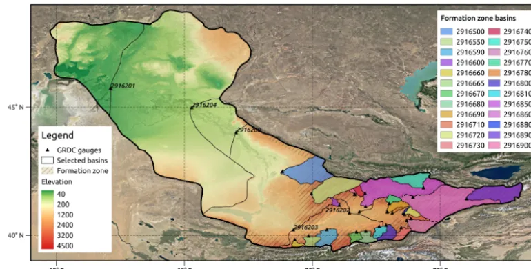
The main part of the Small Aral Sea basin (Fig. 1) is occupied by the Syr Darya river and its tributaries which contribute around 40 km3 of freshwater inflow annually (Radchenko et al., 2017). About 70 % of the runoff of the Syr Darya river basin originates in the Kyrgyzstan mountain ranges and the main contribution of this volume corresponds to Ferghana Valley river basins (Belyaev, 1995; Radchenko et al., 2017). In our research, we have selected 24 basins which run to
the Ferghana Valley as the main source of hydrological in-sights and information about runoff generation in the fresh-water formation zone of the Small Aral Sea (Fig. 1). These basins are highly contrasting in geographical and hydrocli-matic conditions, and cover a range of areas from 150 to 24 000 km2. For a detailed geographical description of Fer-ghana Valley river basins please refer to Radchenko et al. (2017).
2.2 Runoff and meteorological forcing data
Observed runoff data for selected basins were provided by the Global Runoff Data Centre (GRDC; http://www.bafg. de/GRDC/). Only for 2 basins of 24 there were daily ob-served runoff time series, therefore in our work we used only monthly observations for holding methodological con-sistency. Runoff data availability is the main limit for de-veloping and validation of our methodology by the reason of the majority of available observations lie in the interval from 1975 to 1985. For the modern studies related to con-temporary water resources assessment on vast territories, it is essential to use global gridded data products as the only spatial and temporal continuous source. For this reason, all models were driven by precipitation and temperature data from the ERA-40 reanalysis (1957–2002, 0.5◦spatial reso-lution, http://apps.ecmwf.int/datasets/, Uppala et al., 2005). Potential evapotranspiration is another required forcing vari-able for all models and it was derived based on Oudin et al. temperature-based equation (Oudin et al., 2005).
3 Methods and software
3.1 Hydrological models
Figure 1.The Small Aral Sea basin and selected river basins.
which finds the global minimum of a multivariate function (http://docs.scipy.org, Storn and Price, 1997).
3.2 Machine learning models
For runoff modeling, we have used different machine learning models starting from simple MLP (Multiple Lin-ear Regression) and wide-based decision tree ensembles of ETR (Extra Trees Regression) to the most compli-cated depth-based tree ensembles of LGB (Light Gradi-ent Boosting machine) and XGB (eXtreme GradiGradi-ent Boost-ing machine). MLP and RFR were implemented by us-ing the Scikit-learn package (https://github.com/scikit-learn/ scikit-learn, Pedregosa et al., 2011), LGB was taken from the LightGBM package (https://github.com/Microsoft/ LightGBM, Zhang et al., 2017), LGB was taken from XG-boost package (https://github.com/dmlc/xgXG-boost, Chen and Guestrin, 2016). Machine learning model parameters tun-ing requires a lot of expertise and experimentation and can-not be resolved automatically because of high computa-tional complexity (Snoek et al., 2012), therefore we had cal-ibrated required parameters manually. For deriving predic-tions in ensemble manner and approaching realism in the model setting we have used leave-one-out cross-validation technique for machine learning model performance assess-ment (Ayzel, 2017; Hastie et al., 2001) – as a result, we eval-uated model performance on every observational point inde-pendently and produced ensemble realization according to the amount of runoff observation we use. This setting pro-vides us most comprehensive evaluation protocol for ma-chine learning models and uncertainties related to models’ structures.
3.3 Feature engineering
Feature engineering is an essential part of any routine of ma-chine learning model developing. The general idea of feature engineering is to map already existed features of data to the new representation (dimension). Two (among others) classi-cal implementations of these techniques are extending data with adding some features shifted in time (further referred as LAGS) and shrinking data dimensionality with principal component analysis (PCA) orthogonal transformation algo-rithm (Hastie et al., 2001). We have tested performances of our machine learning models with default input features, us-ing LAGS and PCA separately and in a coupled settus-ing, and then select the best combination in term of runoff predictions accuracy.
3.4 Workflow representation
Figure 2.Runoff modeling workflow.
runoff formation zone which serves us as additional input data source for runoff modeling using machine learning mod-els: for the first gauge in our cascade on the Syr Darya river – Kal – we have used both gridded meteorological and for-mation zone runoff forcing as input, the same for the next gauge in a cascade – Bekabad – but with added mean ensem-ble modeled runoff realization from Kal. For the remaining two gauges in a cascade (Tyumen Aryk and Kazalinsk), we used only meteorological forcing and mean ensemble mod-eled runoff realization from overlying gauge in a cascade.
4 Results and discussion
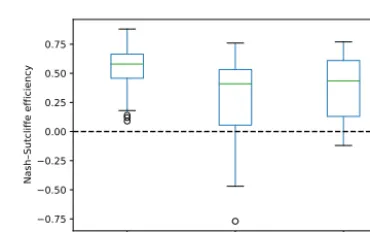
Model calibration results differ from model to model and from different complexity of optimization algorithm. Only one setting with HBV model and the most computation-ally expensive realization of differential evolution algo-rithm (number of iteration equals 25) provides positive val-ues of NSE for every single basin (Fig. 3) and we have decided to use only this set-up for further investigations. Only five of selected basins have an NSE less than 0.45 – all of them (GRDC ids: 2916590, 2916660, 2916665, 2916670, 2916810) are located on a north exposition of Alay range. These low efficiencies can be explained by errors in GRDC observational runoff data or errors in basins’ meta-data (wrong coordinates of outlets, basin areas) which are quite hard to detect and check in the open literature and web sources. Inter-comparison of obtained modeling results with different studies (Lutz et al., 2012b; Pereira-Cardenal et al., 2011; Radchenko et al., 2017; Siegfried et al., 2012) shows high consistency among different approaches for modeling water balance in the upper and mountainous part of the Syr Darya river. Therefore we showed positive value of using freely available data sources for water balance modeling in the study area and tried to transfer this value to the grid-ded runoff database of the Small Aral Sea (runoff) formation zone using the most robust way of model parameters
region-HBV GR4J SIMHYD
0.75 0.50 0.25 0.00 0.25 0.50 0.75
Nash–Sutcliffe efficiency
Figure 3.Boxplot of NSE for formation zone basins.
alization (Ayzel et al., 2017). Using developed gridded runoff dataset for extracting runoff realization for 24 selected basins in a semi-distributed manner shows good consistency with realizations were produced by lumped model setting with op-timal parameters.
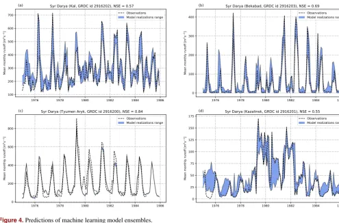
1976 1978 1980 1982 1984 1986 100 200 300 400 500 600 700 M e a n m o n th ly r u n o ff [ m 3s 1]
(a) Syr Darya (Kal, GRDC id 2916202), NSE = 0.57
Observations Model realizations range
1976 1978 1980 1982 1984 1986
0 100 200 300 400 M e a n m o n th ly r u n o ff [ m 3s 1]
(b) Syr Darya (Bekabad, GRDC id 2916203), NSE = 0.69
Observations Model realizations range
1976 1978 1980 1982 1984 1986
0 200 400 600 800 M e a n m o n th ly r u n o ff [ m 3s 1]
(c) Syr Darya (Tyumen Aryk, GRDC id 2916200), NSE = 0.84
Observations Model realizations range
1976 1978 1980 1982 1984 1986
0 25 50 75 100 125 150 175 M e a n m o n th ly r u n o ff [ m 3s 1]
(d) Syr Darya (Kazalinsk, GRDC id 2916201), NSE = 0.55
Observations Model realizations range
Figure 4.Predictions of machine learning model ensembles.
Table 1.Runoff modeling results.
Gauge, GRDC id Machine learning models Feature engineering
efficiency (NSE)
MLR ETR LGB XGB
Kal (2916202) 0.56 0.56 0.58 LAGS, PCA
Bekabad (2916203) 0.67 0.66 0.73
Tyumen Aryk (2916200) 0.84
Kazalinsk (2916201) 0.56 0.54 LAGS
model because of little factors of water redistribution in this local region. But we need more (in terms of quality, quan-tity, and diversity) data to map more complicated relation-ships for Kal and Kazalinsk because of high load of water management system on runoff formation/transformation pro-cesses. There is no clear pattern in models’ efficiency for spe-cific gauges – models rank differently in different settings. Nevertheless, we consider that the best solution in our case is to use both linear MLR and non-linear XGB with differ-ent feature engineering techniques for maximizing the spread of possible solutions. Obtained results are in the upper part of NSE range as in Gudmundsson and Seneviratne (2015) who provided monthly runoff predictions for a set of Europe river basins using Random Forest model and Watch Forc-ing Data (http://www.eu-watch.org/data_availability) as
in-put forcing – this result underlines the crucial value of added gridded runoff information to machine learning model inputs which allows comparable model performance with European basins.
com-plexity of processes we have to consider, the same is rel-evant for the gauge station in Kazalinsk which affected by many, often fuzzy and unclear water management practices (Fig. 4d). This result is also confirmed by the complexity of preprocessing routine – for the simplest cases (Bekabad and Tyumen Aryk gauge stations) we do not need to implement either PCA or LAGS for mapping features for a different di-mension.
There is about 100 km from Kazalinsk gauge station to the actual Syr Darya delta, and there are a lot of channels, ponds, and other water management infrastructure units (e.g. the Aklak water regulation station) which can affect total fresh-water inflow in the Small Aral Sea basin, but for consistency with previous studies (Lutz et al., 2012a; Raskin et al., 1992) we consider the equality between observed runoff in Kaza-linsk and freshwater inflow to the sea. Only a brief look on the observed runoff time series in Kazalinsk (Fig. 4d) gives any researcher a clear representation of high complexity of runoff formation system behavior here – we can only de-tect simple seasonal pattern with maximum water availabil-ity during winter, but it is impossible to generalize remaining runoff amplitude according to natural reasons. Nevertheless, XGB and ETR models utilize this complexity well due to their native algorithmic structures based on simple binarized decision rules which try to mimic decision-making process takes place in many real-life situations. Despite the clear at-traction of observations to lower and upper boundaries of our prediction interval which may identify unstable system be-havior, there is an obvious correlation between observed and modeled runoff.
Despite the limited observed runoff data availability for this region (mainly for 1975–1985) which was the main constraint in implementing comprehensive routines for pro-posed methodology validation, obtained machine learning model-based ensemble realizations of freshwater inflow into the Small Aral Sea for the period of 1958–2002 (alongside the forcing data availability) could form the basis for fur-ther “Soviet-driven water management” scenario predictions which help us better understand modern shifts in water re-sources distribution in post-Soviet time.
5 Conclusions
The complex structure of the Small Aral Sea basin water management system coupled with the total absence of data describes its functioning is a challenge for any approach di-rected to the accurate assessment of the freshwater budget formation and evolution across the basin. Our work shows the possibility to tackle these challenges by coupling hy-drological models with the state-of-the-art machine learning techniques. In detail, we have evaluated the significant value of using physically based models for runoff predictions in un-gauged upper part of the Syr Darya river for developing grid-ded runoff database which can be used as an additional
fea-ture for machine learning model in a coupled setting. Results show a positive skill and a high flexibility of the proposed methodology, and in our perspective, it can be used widely as a baseline approach for water balance research studies in arid, ungauged areas, with complex water management sys-tem and strong water-related data scarcity.
We understand that an equality between freshwater inflow into the Small Aral Sea and observed runoff in Kazalinsk is quite a rough assumption, and in the further studies, we will try to assess real inflow by coupling simple seawater balance model to our existing modeling system.
The code and data we have developed are totally open and freely accessible. We hope that this supports reproducibility of our research and provides easy access to the community to test, criticize, or apply our findings.
Code and data availability. Raw data were downloaded from
ECMWF Public Datasets web interface (http://apps.ecmwf.int/ datasets/) and GRDC archive (http://www.bafg.de/GRDC/, via re-quest). For using raw data you have to agree with correspond-ing data policies from ECMWF and GRDC. You can find all code and data (under MIT license) on our project Github page (https://github.com/SMASHIproject/IWRM2018; Ayzel and Izhit-skiy, 2017). There are no restrictions on use or distribution of our software code and data.
Competing interests. The authors declare that they have no
con-flict of interest.
Special issue statement. This article is part of the special issue
“Innovative water resources management – understanding and bal-ancing interactions between humankind and nature”. It is a result of the 8th International Water Resources Management Conference of ICWRS, Beijing, China, 13–15 June 2018.
Acknowledgements. This work was undertaken within the
frame of the SMASHI project (http://smashiproject.github.io) and was funded by the Russian Foundation for Basic Research (RFBR), project 17-05-01175 A. The part of presented study related to the developing, adapting and implementing of conceptual hydrological model was financially supported by the Russian Science Founda-tion (grant number 16-17-10039). The Global Runoff Data Centre (GRDC) is gratefully acknowledged for providing observed runoff data.
Edited by: Wenchao Sun
References
Apel, H., Abdykerimova, Z., Agalhanova, M., Baimaganbetov, A., Gavrilenko, N., Gerlitz, L., Kalashnikova, O., Unger-Shayesteh, K., Vorogushyn, S., and Gafurov, A.: Statistical forecast of seasonal discharge in Central Asia for water re-sources management: development of a generic linear mod-elling tool for operational use, Hydrol. Earth Syst. Sci. Discuss., https://doi.org/10.5194/hess-2017-340, in review, 2017.
Ayzel, G.: LHMP: First major release,
https://doi.org/10.5281/zenodo.59680, 2016.
Ayzel, G.: Use of machine learning techniques for
modeling of snow depth, Ice and Snow, 34–44,
https://doi.org/10.15356/2076-6734-2017-1-34-44, 2017. Ayzel, G. and Izhitskiy, A.: Data, code, and results for the
paper “Coupling physically based and data-driven models for assessing freshwater inflow into the Small Aral Sea”, https://doi.org/10.5281/zenodo.1161906, 2017.
Ayzel, G. V., Gusev, E. M., and Nasonova, O. N.: River
runoff evaluation for ungauged watersheds by SWAP
model. 2. Application of methods of physiographic simi-larity and spatial geostatistics, Water Resour., 44, 547–558, https://doi.org/10.1134/S0097807817040029, 2017.
Beck, H. E., van Dijk, A. I. J. M., de Roo, A., Mi-ralles, D. G., McVicar, T. R., Schellekens, J., and Brui-jnzeel, L. A.: Global-scale regionalization of hydrologic model parameters, Water Resour. Res., 52, 3599–3622, https://doi.org/10.1002/2015WR018247, 2016.
Belyaev, A. V.: Water Balance and Water Resources of the Aral Sea Basin and Its Man-Induced Changes, GeoJournal, 35, 17– 21, 1995.
Chen, T. and Guestrin, C.: XGBoost: Reliable Large-scale Tree Boosting System, available at: https://arxiv.org/abs/1603.02754 (last access: 13 February 2018), 2016.
Chen, Y., Li, W., Fang, G., and Li, Z.: Review article: Hydro-logical modeling in glacierized catchments of central Asia – status and challenges, Hydrol. Earth Syst. Sci., 21, 669–684, https://doi.org/10.5194/hess-21-669-2017, 2017.
Chiew, F. H. S., Teng, J., Vaze, J., Post, D. A., Perraud, J. M., Kirono, D. G. C., and Viney, N. R.: Estimating climate change impact on runoff across southeast Australia: Method, results, and implications of the modeling method, Water Resour. Res., 45, W10414, https://doi.org/10.1029/2008WR007338, 2009. Gan, R., Luo, Y., Zuo, Q., and Sun, L.: Effects of projected
climate change on the glacier and runoff generation in the Naryn River Basin, Central Asia, J. Hydrol., 523, 240–251, https://doi.org/10.1016/j.jhydrol.2015.01.057, 2015.
Gudmundsson, L. and Seneviratne, S. I.: Towards observation-based gridded runoff estimates for Europe, Hydrol. Earth Syst. Sci., 19, 2859–2879, https://doi.org/10.5194/hess-19-2859-2015, 2015.
Hagg, W., Braun, L. N., Weber, M., and Becht, M.: Runoff modelling in glacierized Central Asian catchments for present-day and future climate, Nordic Hydrology, 37, 93–105, https://doi.org/10.2166/nh.2006.001, 2006.
Hagg, W., Braun, L. N., Kuhn, M., and Nesgaard, T. I.: Modelling of hydrological response to climate change in glacierized Central Asian catchments, J. Hydrol., 332, 40–53, https://doi.org/10.1016/j.jhydrol.2006.06.021, 2007.
Hastie, T., Tibshirani, R., and Friedman, J.: The Elements of Statis-tical Learning, Springer Series in Statistics, Springer New York Inc., https://doi.org/10.1007/978-0-387-84858-7, 2001. Immerzeel, W. W. and Bierkens, M. F. P.: Asia’s water balance, Nat.
Geosci., 5, 841–842, https://doi.org/10.1038/ngeo1643, 2012. Izhitskiy, A. S., Zavialov, P. O., Sapozhnikov, P. V., Kirillin, G. B.,
Grossart, H. P., Kalinina, O. Y., Zalota, A. K., Goncharenko, I. V., and Kurbaniyazov, A. K.: Present state of the Aral Sea: diverg-ing physical and biological characteristics of the residual basins, Scientific Reports, 6, 23906, https://doi.org/10.1038/srep23906, 2016.
Jarsjö, J., Asokan, S. M., Prieto, C., Bring, A., and Destouni, G.: Hydrological responses to climate change conditioned by his-toric alterations of land-use and water-use, Hydrol. Earth Syst. Sci., 16, 1335–1347, https://doi.org/10.5194/hess-16-1335-2012, 2012.
Lindström, G., Johansson, B., Persson, M., Gardelin, M., and Bergström, S.: Development and test of the distributed HBV-96 hydrological model, J. Hydrol., 201, 272–288, https://doi.org/10.1016/S0022-1694(97)00041-3, 1997. López, O., Houborg, R., and McCabe, M. F.: Evaluating the
hydro-logical consistency of evaporation products using satellite-based gravity and rainfall data, Hydrol. Earth Syst. Sci., 21, 323–343, https://doi.org/10.5194/hess-21-323-2017, 2017.
Lutz, A., Droogers, P., and Immerzeel, W.: Climate Change Impact and Adaptation on the Water Resources in the Amu Darya and Syr Darya River Basins. FutureWater Report 110, Tech. rep., FutureWater, available at: http://www.futurewater.eu/ wp-content/uploads/2013/01/CC_Downstream_Report_V51.pdf (last access: 13 February 2018), 2012a.
Lutz, A., Immerzeel, W., and Droogers, P.: Climate Change Impacts on the Upstream Water Resources of the Amu and Syr Darya River Basins. FutureWater Report 107, Tech. rep., FutureWa-ter, available at: http://www.futurewater.eu/wp-content/uploads/ 2012/03/Upstream_Report_FW_web.pdf (last access: 13 Febru-ary 2018), 2012b.
Micklin, P.: The Aral Sea Disaster, Annu. Rev. Earth Planet. Sc., 35, 47–72, https://doi.org/10.1146/annurev.earth.35.031306.140120, 2007.
Nash, J. E. and Sutcliffe, J. V.: River flow forecasting through con-ceptual models part I – A discussion of principles, J. Hydrol., 10, 282–290, https://doi.org/10.1016/0022-1694(70)90255-6, 1970. Oudin, L., Hervieu, F., Michel, C., Perrin, C., Andréassian, V.,
Anctil, F., and Loumagne, C.: Which potential evapotranspi-ration input for a lumped rainfall-runoff model? Part 2 – Towards a simple and efficient potential evapotranspiration model for rainfall-runoff modelling, J. Hydrol., 303, 290–306, https://doi.org/10.1016/j.jhydrol.2004.08.026, 2005.
Oudin, L., Andréassian, V., Perrin, C., Michel, C., and Le Moine, N.: Spatial proximity, physical similarity, regression and ungaged catchments: A comparison of regionalization approaches based on 913 French catchments, Water Resour. Res., 44, W03413, https://doi.org/10.1029/2007WR006240, 2008.
Pereira-Cardenal, S. J., Riegels, N. D., Berry, P. A. M., Smith, R. G., Yakovlev, A., Siegfried, T. U., and Bauer-Gottwein, P.: Real-time remote sensing driven river basin modeling us-ing radar altimetry, Hydrol. Earth Syst. Sci., 15, 241–254, https://doi.org/10.5194/hess-15-241-2011, 2011.
Perrin, C., Michel, C., and Andréassian, V.: Improvement of a parsi-monious model for streamflow simulation, J. Hydrol., 279, 275– 289, 2003.
Radchenko, I., Dernedde, Y., Mannig, B., Frede, H.-G., and Breuer, L.: Climate change impacts on runoff in the Fer-ghana Valley (Central Asia), Water Resour., 44, 707–730, https://doi.org/10.1134/S0097807817050098, 2017.
Raskin, P., Hansen, E., Zhu, Z., and Stavisky, D.: Simulation of Wa-ter Supply and Demand in the Aral Sea Region, WaWa-ter Int., 17, 55–67, https://doi.org/10.1080/02508069208686127, 1992. Reichl, J. P. C., Western, A. W., McIntyre, N. R., and Chiew,
F. H. S.: Optimization of a similarity measure for estimat-ing ungauged streamflow, Water Resour. Res., 45, W10423, https://doi.org/10.1029/2008WR007248, 2009.
Shi, W., Wang, M., and Guo, W.: Long-term hydrological changes of the Aral Sea observed by satellites, J. Geophys. Res.-Oceans, 119, 3313–3326, https://doi.org/10.1002/2014JC009988, 2014. Shibuo, Y., Jarsjö, J., and Destouni, G.: Hydrological
re-sponses to climate change and irrigation in the Aral
Sea drainage basin, Geophys. Res. Lett., 34, l21406,
https://doi.org/10.1029/2007GL031465, 2007.
Siegfried, T., Bernauer, T., Guiennet, R., Sellars, S., Robertson, A. W., Mankin, J., Bauer-Gottwein, P., and Yakovlev, A.: Will climate change exacerbate water stress in Central Asia?, Cli-matic Change, 112, 881–899, https://doi.org/10.1007/s10584-011-0253-z, 2012.
Snoek, J., Larochelle, H., and Adams, R. P.: Practical Bayesian Optimization of Machine Learning Algorithms, in: Advances in Neural Information Processing Systems 25, edited by: Pereira, F., Burges, C. J. C., Bottou, L., and Weinberger, K. Q., 2951–2959, Curran Associates, Inc., 2012.
Sorg, A., Mosello, B., Shalpykova, G., Allan, A., Hill Clarvis, M., and Stoffel, M.: Coping with changing water resources: The case of the Syr Darya river basin in Central Asia, Environ. Sci. Policy, 43, 68–77, https://doi.org/10.1016/j.envsci.2013.11.003, 2014.
Storn, R. and Price, K.: Differential Evolution – A Sim-ple and Efficient Heuristic for global Optimization over
Continuous Spaces, J. Global Optim., 11, 341–359,
https://doi.org/10.1023/A:1008202821328, 1997.
Uppala, S. M., Kållberg, P. W., Simmons, A. J., Andrae, U., Bech-told, V. D. C., Fiorino, M., Gibson, J. K., Haseler, J., Hernandez, A., Kelly, G. A., Li, X., Onogi, K., Saarinen, S., Sokka, N., Al-lan, R. P., Andersson, E., Arpe, K., Balmaseda, M. A., Beljaars, A. C. M., Berg, L. V. D., Bidlot, J., Bormann, N., Caires, S., Chevallier, F., Dethof, A., Dragosavac, M., Fisher, M., Fuentes, M., Hagemann, S., Hólm, E., Hoskins, B. J., Isaksen, L., Janssen, P. A. E. M., Jenne, R., Mcnally, A. P., Mahfouf, J.-F., Morcrette, J.-J., Rayner, N. A., Saunders, R. W., Simon, P., Sterl, A., Tren-berth, K. E., Untch, A., Vasiljevic, D., Viterbo, P., and Woollen, J.: The ERA-40 re-analysis, Q. J. Roy. Meteor. Soc., 131, 2961– 3012, https://doi.org/10.1256/qj.04.176, 2005.
Valéry, A., Andréassian, V., and Perrin, C.: “As simple as possible but not simpler”: What is useful in a temperature-based snow-accounting routine? Part 1 – Comparison of six snow account-ing routines on 380 catchments, J. Hydrol., 517, 1166–1175, https://doi.org/10.1016/j.jhydrol.2014.04.059, 2014.
Zavialov, P. O., Kostianoy, A. G., Emelianov, S. V., Ni, A. A., Ish-niyazov, D., Khan, V. M., and Kudyshkin, T. V.: Hydrographic survey in the dying Aral Sea, Geophys. Res. Lett., 30, 1659, https://doi.org/10.1029/2003GL017427, 1659, 2003.
hang, H., Si, S., and Hsieh, C.-J.: GPU-acceleration for Large-scale Tree Boosting, available at: http://arxiv.org/abs/1706.08359 (last access: 13 February 2018), 2017.