New Algorithms on the Solution to Drifting
Problem of GPS Positioning
Huang Guanli
Beijing Vocational College of Electronic Science,Beijing, China Email: [email protected]
Yang Bin
Dept. of Electronic and Information Eng., Beihang University, Beijing, China
Jiang Keyu
Dept. of Informatics, Fort Hays State University, KS 67601 - 4099, USA Email: [email protected]
Abstract—Make the balance among the signal power and
solve GPS drifting problem has become the new research focus. The approaches of the algorithms adjustment and checking are conducted in the GPS storage location. For guaranteeing the quality of the relevant GPS software and not restricted by data type and source, two new algorithms is designed. Key parameters of the algorithm can be manually-controlled and suited to the different data sets and the movement objects. Hence the requirement for the GPS receiver performance can be reduced and the limited capability weakness of the embedded computing is compensated. However, the proposed algorithms can not achieve much more performance gain with a poor quality GPS position data. For guaranteeing the quality of the relevant GPS software and not restricted by data type and source,two new algorithms is designed. Key parameters of the algorithm can be manually-controlled and suited to the different data sets and the movement objects. The proposed algorithms are better methods for data secondary discrimination and correction with high quality GPS data. Moreover, with the development and maturity of the time series method, the proposed algorithm will have more potential to grow and establish. The algorithms which based on temporal series and Euclidean space make improvement for the positioning accuracy of GPS data.
Index Terms—problem of drifting, temporal series,
euclidean space, flat noise
I. INTRODUCTION
The weak receiving capability of GPS receiver may render it difficult or impossible to acquire and track the satellite signals, and hence losing the positioning function. However, strong receiving capability may also degrade the function. The satellite transmits electromagnetic wave signals which may reflect off surrounding terrain, buildings, canyon, walls, hard ground, etc. in the city. These delayed signals may finally interfere with the true signal and cause the inaccuracy of the positioning, the so called drafting problem [1]. Therefore how to make the balance among the signal
power is of importance for researchers and software developers as well.
Since 2000, the computer software based on GPS technology have been burgeoning. GPS receivers have been available for pedestrians, vehicles and other moving targets where GPS antennas or GPS vehicle computers can be equipped [2]. Those GPS receivers can relay the position data to a remote computer data processing center through wireless channel using Bluetooth or GPRS etc. Through matching the position data with the electronic map, the GPS receiver locations can be marked on the map with computer software. With the location information, the operator can easily make decisions and send command to schedule resources, achieving reasonably quick responses to custom requests, by efficiently monitoring and scheduling the vehicles, pedestrians as well as other corporation resources. Therefore such computer software have very board market prospects [3].
We must be clear that the current available GPS software for monitoring and scheduling have some congenital defects as a result of the different qualities of the position data provided by the different GPS receivers, such as the drafting problem mentioned above, which may lead to crash of the computer software, disappearance of the monitored target or disorder of the moving target’s tracks, etc. These phenomena significantly limit the quality of software products and the satisfaction of application, reducing the market value and credibility of GPS-based monitoring, scheduling, and navigating software [4]. Thus the quality of the GPS computer software, now available in market, is also different.
algorithms, which all should be considered by the hardware providers [5]. For the GPS application software developers, first it is important to reduce the distortion of position data from the GPS receiver by selection of suitable hardware. Further, we can introduce a secondary processing to the GPS position data before importing them into the application software by screening out or correcting the error data . In this paper, we will realize this idea through the generic process of GPS software development.
II. PROCESSOFGPSCOMPUTERSOFTWARE DATAFLOW
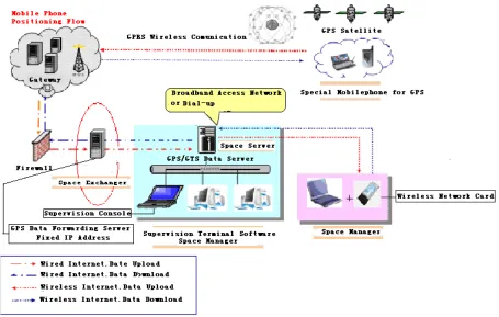
Most of on-the-shelf GPS software products, such as corporation business management system, vehicle monitoring system, and GPS navigation equipment including both hardware and software, share the similar working principle, display the position data received from GPS receiver on the vector map using the GIS technology [6].With these position data, many kinds of computer software can be developed to illustrate the information of the position data on the application layer such as map, report, and animation, etc [7]. The whole process of the position data flow is shown in Figure 1. In this figure, it is clear that the received GPS data is transmitted to the GPS data sever through wireless channel. The error data, introduced by the receiver, or directly from the satellite, will cause the GPS position data drafting and the software drafting, leading to the track of the moving target irregularly jump or even disappear. As the software engineers directly use the original position data which may contain error without any pretreatment or screening,
the quality of the computer software will greatly be degraded [8]. To improve the efficiency of the monitoring, the easiest way is to screen out or correct the original position data with some algorithms before they are stored at the GPS data server
III. FUNDAMENTALOFTHE ERROR GPSDATA CORRECTION
A. Review of the Related Correction Algorithms
Currently most of the popular GPS navigators enhance the GPS signal processing functions at the GPS receiver to dramatically improve the reliability of the position data. Some famous GIS software providers, such as SuperMap, LingTu and ARCGIS etc., also integrate the position data inspection, correction, and error-tolerant algorithms in their map ActiveX and provide the road-locking function, ensuring the target is moving along the right path in the road, so a moving target can be well illustrated on the maps with those activex [9]. However, those algorithms require payments to acquire. Those activex require high quality hardware to support. Furthermore, due to those algorithms are coded inside the activex, the users can not modify the related parameters to adapt to their own type of position data, which leads to a limited error tolerance. When the mount of error data exceeds a certain threshold, the fault and defects mentioned above will appear again[10]. For the most of the software develop companies, how to improve their product quality through a simple and feasible algorithm is what this paper focuses on.
B. The Targeted Critical Problems of the Correction Algorithm Design
For software developers, to improve the quality of the GPS data, in addition to the selection of the good hardware, the algorithm design should solve the following problems:
(1) Determine where and when to employ the correction algorithms for GPS data.
(2) Determine the criteria to evaluate the GPS error data.
(3) Determine the method to correct the GPS error data.
Here we propose two theories to correct the drafting position data for two algorithms design.
C. The DistancePrinciple in Euclidean Space
It is well known that the GPS receiver receives three different kinds of data from the GPS satellite, a moving target with velocity v and location p, and the time t [11]. In the ECEF coordinate system, we propose a simple algorithm using the Euclidean distance as the metric to evaluate the data.
(1) Assuming the two arbitrary location of the moving target on earth with Longitude A1、A2(E positive,W negative)and Latitude B1、B2(N positive,S negative), where E, W, N, S represent four directions east, west, north, and south.
(2) Let 1 2 1 2
0 0
( ) ( )
;
2 2
A A B B
A = − B = − , based on Euclidean geometric principle, the minimum spherical distance between those two points can be calculated as following:
2 arcsin
d= R f
where R represents the earth radius, and f= sin 0B 2+cos 1 cos 2sin 0B × B A 2.
(3) We assume that GPS receiver receives the position data with a constant interval time t. (In the monitoring software, this interval time can be set manually, generally no more than 10sec.) Since the moving target velocity v is provided by the GPS receiver, thus during the interval t the target moves a distance D=vt.
(4) The first critiria.
Based on the aforementioned spherical distance equation, during the time interval t, the spherical distance between two point is denoted as d. In practice, during the time interval the incremental distance d of the moving target should be limited in an incremental range, which is shown in Table 1. If the incremental distance exceeds its range, the received position data can be recognized as an
error data. Then we need to correct this position data [12].
(5) The second criteria.
The ratio between D and d should fluctuate at the value of 1. When the difference between this ratio and value 1 exceeds a limit, such as±0.5, we treat this GPS position data as an error data, which should be corrected.
(6) Processing of singularities or error data.
Based on the above two singular point determination rules, the singular points of the position data can be recognized, which can be smoothed out using the following three approaches:
i). Delete the singular points.
ii). Replace the singular point with the previous data point.
iii).Replace the singular point with a value extrapolated by previous data based on the Hermite or spline interpolation algorithm.
D. Time Series Method
Time series method is a quantitative prediction method, also called as simple extrapolation method, which is widely used in statistics as a common data analysis approach. Before the World War Ⅱ it was used for economic forecasting. During and after the World War Ⅱ, it was widely applied to many other fields such as military science, space science, weather forecasting, and industrial automation etc. We can apply the time series method for the GPS data processing in order to detect and correct the singular data points [13]. Based on the time series method the proposed correction algorithm is as follows:
(1) Get the moving target longitude observation points (generally required for more than 50 samples).
1 2 3
( , , . . . n )
x = x x x x
n
≥
50
(2) Let the observation time as the horizontal coordinates, moving target longitude as the vertical coordinates, to form a time series of longitude variation.
(3) Let k varying from 1 to n-1 with incremental of 1, and calculate the k-order auto-correlation coefficient of the samples to obtain the auto-correlation coefficient series:
1 2 3 1
( , , ...
n)
r
=
r r r
r
−2 2 1 2 1 1 ( ) ( ) 1 ; ( ) n k
i i k n
i
k n i
i i
i
X X X X
r X X
n X X − + = = = − − = = −
∑
∑
∑
wher eTABLE I.
THE DISTANCE INCREMENTAL RANGE OF A MOVING TARGET AT A GIVEN TIME PERIOD
Movement t=2s t=5s t=10s
Walk(m) 0.5—1 2.5—5 5—10
Bicycle(m) 5—10 25—50 50—100
Car(m) 10—20 50—100 100—200
(4) To determine the reliability of the original series x, we can either examine the distribution graph of the correlation coefficient series, or check whether the auto-correlation coefficient series is white noise based on the Dickey-Fuller white noise hypothesis testing method.
(5) If the longitude time series x is reliable, no singular points exist, and the GPS position data have no draft.
(6) If series x is not reliable, go to step (7).
(7) If the longitude time series x has the trend of increase or decrease with time, logarithmic transformation will be applied to the series x to form a new time series y =lnx:
ln( )
i i
y
=
x
If the series x is fluctuated over the time, apply differential transformation with delay s to form a new time series
y
=
+
sx
:
(
)
i s i i i s
y
=
+
x
=
x
−
x
−If the series x has both of aforementioned characteristics, use both of logarithmic transformation and differential transformation to form a new time series
ln( )
s
y
=
+
x
, where s is an empirical value.(8) With the new time series y, repeat steps from (2) to (4).
(9) After steps from (1) to (8), if the series does not pass the white noise test, it means the series x not reliable with singular points , and the position data has drift.
(10) With the thread from auto-correlation coefficient series, locally testing the samples from series x to identify the singular point and correct it.
(11) To correct the singular point, three methods may be employed:
i). Delete the singular point.
ii). Replace the singular point with the previous data point.
iii). Replace the singular point with a value extrapolated from previous data based on the Hermite or spline interpolation algorithm.
(12) Do the same processing to the latitude position data.
IV. SIMULATIONONTHETIME SERIES
A. Methods Comparing
Since the method based on Euclidean distance principleis used more subjectively, the first algorithm is more appropriate for software engineering[14].
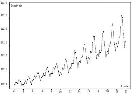
The time series method is more theoretical, and in this paper, we will illustrate the science and rigorousness of this second algorithm with an example. 114 points of position data are sampled from a moving target, and the longitude time series of the moving target is plotted in Fig. 2. In Fig. 2, it is clear that the Longitude time series are fluctuated over the time and have an increasing trend. The peaks periodically appear and the amplitude of the peaks increases with the time [15]. Due to the growth inhibition property of the ln operator on signal
processing, ln operator is applied to the longitude time series to inhibit the peaks growth, as illustrated in Fig. 3.
In Fig. 3, the periodic peak growth was inhibited obviously. However, the overall trend of this series is still increasing. Considering the sample rate is 0.1/s and the cycle time of the data is 12, we apply the
∆
12ln
operator on the longitude time series (here, the ln operator are required to be removed) to inhibit the overall growth trend of the time series, and the new time series are plotted in Fig. 4.Figure 2. The Longitude time series of moving target.
Comparing with Fig. 1, the time series in Fig. 4 doesn’t have the overall growth trend and the amplitude of the cyclical peaks does not increase. Thus, the stability of the original time series can be analyzed based on this result.
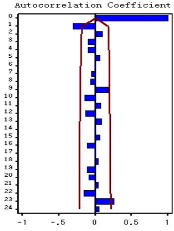
B. The Auto-correlation Coefficients of the Time Series The auto-correlation coefficients of the time series are plotted in Fig. 5. After the first observation point, the auto-correlation coefficients automatically converge within the confidence range, indicating the Longitude position data of the moving target is normal and the position data does not show obvious draiting.
With the Dickey-Fuller testing, the results are shown in Table II.
The values of the fourth row in Table II do not reject the white noise hypothesis of the auto-correlation coefficients which indicates that this time series is stable. Therefore the Longitude position data is a smooth process and accurate. the Longitude position data does not show obvious drifting during the target movement [16]. On the other hand, if the original position data shown in Figure 2 drifts, the time series will have a singular point, as shown in Fig. 6.
After the differential transformation with operator on the data in Fig. 5, we verify the stability of the new time series.
The auto-correlation coefficients of the new time series are shown in Figure 7. The auto-correlation coefficient value increases irregularly when the delay equals to 12, which indicates that this time series is not a smooth process and the Longitude position data has obvious drift during the target movement[17].
Based on the test results, we can find the position of singular point and replace it with the previous point to stabilize the whole series. The new result of the Dickey-Fuller testing is shown in Table 3.The values in the fourth row reject the white noise hypothesis of the auto-correlation coefficients, indicating that this time series is not stable. In other words, the original position data have obvious drift [18]. Based on the test results, we can find the position of singular point and replace it with the previous one. Then, the time series becomes stable. Figure 6. The time series of drafting position data.
TABLE III.
DICKEY-FULLER HYPOTHESIS TEST RESULTS OF THE NEW TIME SERIES
Delay Chi-square DF Pr>chisq Auto-correlation coefficients
6 28.25 6 <.0001 -0.446 0.001 -0.052 0.002 -0.048 0.079
12 70.62 12 <.0001 -0.051 0.033 0.013 -0.008 0.238 -0.479
TABLE II.
DICKEY-FULLER HYPOTHESIS TEST RESULTS
Delay Chi-square DF Pr>chisq Auto-correlation coefficients
6 5.56 4 0.2349 0.022 0.024 -0.125 -0.129 0.057 0.065
12 8.49 10 0.5816 -0.065 -0.042 0.102 -0.060 0.023 0.007
18 13.23 16 0.6560 0.022 0.039 0.045 -0.162 0.035 0.001
24 24.99 22 0.2978 -0.106 -0.104 -0.037 -0.027 0.219 0.040
V. CONCLUSIONS
While the most of GPS systems process and correct the GPS position data at the GPS receiver through the hardware approach. In this paper, a processing and correction algorithm based on the time series analysis is proposed which can be implemented at the GPS transfer server.
This proposed algorithm is aimed to improve the quality of the GPS software products and satisfaction of users, which is not limited by the data categories and sources, and can be widely used. The key parameters of the proposed algorithm can be manually adjusted and controlled to adapt to the different moving targets and data sets [19]. Moreover it can substantially cut down the GPS software develop cost for those software companies which cannot afford the GPS and GIS developing activex and achieve relatively high performance, error tolerance and quality.
The method of Euclidean distance principle is easier to understand and implement, comparing with the time series analysis, which is much more theoretical and can be extended to process different types of GPS data[20]. Since these algorithms are implemented in the specific computer, a large amount of data can be processed for discrimination and verification. Hence the requirement for the GPS receiver performance can be reduced and the limited capability weakness of the embedded computing is compensated. However, the proposed algorithms can not achieve much more performance gain with a poor quality GPS position data. The proposed algorithms are better methods for data secondary discrimination and correction with high quality GPS data. Moreover, with the development and maturity of the time series method,
the proposed algorithm will have more potential to grow and establish.
ACKNOWLEDGMENT
This work was supported in part by the 2010 Scientific Fund of Beijing Education Commission (ITEM NO. KM201000002002).
REFERENCES
[1] Donald B.Percival, Andrew T.Walden ,Wavelet Methods
for Time Series Analysis[M], China Machine Press , 2004 (5),308~312.
[2] Yang Dongkai,Design and Realization of Delay Mapping
Receiver Based on GPS for Sea Surface Wind Measurement. 2006 International Conference on Industry of Electronics Application 2006. ICIEA2006, Singapore.
[3] Enders, W., Applied Econometric Time Series[M], New
York: John Willey &Sons, Inc,2004.
[4] Yang Dongkai,Sparse Approximation Based on Wavelet
Kernel SVM 2005 The 4th International Conference on Machine Learning and Cybernetics , IEEE, Guangzhou ,2005 (4249-4253),China.
[5] Huang Guanli, Wang Hui, Implement and Improvement on
Data Security Scheme of Dynamic Distributed Diskless Network Storage ,Computer Science,April,2009.
[6] Liu Jingwei, Wang Zuoying, Xiao Xi. Combination of
One-class SVM and HMM for Robust Speech Recognition in Additive Noise Environment. High Technology Letters (supplement). vol 10 Sppl. 85-90,2004.
[7] David A. Dickey and W. A. Fuller, Likelihood Ratio
Statistics for Autoregressive Time Seties With a Unit Root[M], Econometirca, 1981(49), 1057~1072.
[8] Yang Dongkai, Land Vehicle Navigation using GPS and
Dead Reckoning,2003 Natural Journal of Wuhan University No. 7 ,2003
[9] Meng Zhou and Franz Winkler, “On Computing Groebner
Bases in Rings of Differential Operators with Coefficients in a Ring”, Mathematics in Computer Science, Vol. 1 (2) , 2007, 211-223.
[10]Xu Huaping, Huang Guanli ,A new correlation model
ofsingle-look complex images for DSS-SAR , 2007 the IET Internatioal Communication Conference on Wireless
Mobile &Sensor Networks Proceedings,DEC.,2007,shanghai,China.
[11]Jingwei Liu, Zuoying Wang, Xi Xiao. A Hybrid
SVM/DDBHMM Decision Fusion Modelling for Robust Continuous Digital Speech Recognition. PATTERN RECOGNITION LETTER .28(8): 912-920,2007.
[12]Hamilton, J.D., Time Series Analysis[M], Princeton
University Press,1994.
[13]Huang Guanli, A Security System Design of Digital
Signature Based on PKI,computer security ,2008(9),Beijing,China.
[14]Elliott G. , Rothenberg, T.J. and Stock, J.H., Efficient Tests for an Autotegressive Unit Root[J], Econometica, 1996(64), 813~836.
[15]Yang Dongkai,Intelligent Scheduling of Public Traffic Vehicles Based on Hybrid Genetic Algorithm 2003 Proceedings of the IEEE 6th International Conference on Intelligent Transportation Systems, Shanghai, China [16]Huang Guanli, Wang Hui,et al. Research on drifting of
[17]Jingwei Liu,Meizhi Xu. Kernelized Fuzzy Attribute Means Clustering Algorithm. Fuzzy sets and systems.159(18): 2428-2445.2008.
[18]Yang Dongkai,Impact Analysis of Residual Code Phase
and Carrier Frequency Error on GPS Signal Tracking and Its Improvement 2005 International Conference on Space Information Technology. Proceedings of SPIE Vol. 5985 598527,(2005).
[19]Zhang yansheng, Bai xiaoying,Huang Guanli,
Multi-dimensional Evaluation Technique of Software Services, Computer Science,2009(2).
[20]Meng Zhou and Franz Winkler,“Grobner bases in
difference-differential modules and difference-differential dimension polynomials”,Science in China (serious A: Mathematics) Vol. 51(9),2008, 1731-1752.
Huang Guanli, female, born in 1975, Associated professor, Master's degree with the major of computer science. Participant Leader of Beijing Quality Course on Network development and the Committee member on China Computer Federation. Currently an Associate Professor at Beijing Vocational College of Electronic Science. Professor Huang published widely, such as academic articles in Computer Engineering and Applications, Computer Science etc. Professor Huang research interests include algorithm design, Computer Education etc.
Scientific Achievements: Professor Huang has won one National Patents and has published over twenty academic articles as the first author, two of which are EI Indexed. At present, Ms.Huang also undertaked some items ,such as Research and Development on Dynamicdispatching GPS system of the Adaptational Road Condition of the Beijing Education Committee Scientific Project. She is also the Participant of Simulation Platform of Small Hybrid Vehicle Control Based on dSPACE of the Beijing Science and Technology Innovation Platform Project, and Practice of School-enterprise Cooperation Mechanism and Platform Based on Diversification of the Beijing University Education Reform Project,etc.
Research Directions: data analysis ; signal control ; information security; education management
Yang Bin, A graduate student at Beihang University. Male, born in 1985 and received his bachelor degree in Electronic Information Engineering from Beihang University. Currently he is a graduate at Beihang University, majored in Communication and Information System. He will graduate in Jan., 2011
Yang has accomplished six projects in the field of stereoscopic imaging, video compressing, audio signal processing and human-computer interaction, such as Stereo Video System, Real-time Audio Signal Analyzer and so on. Besides those projects, he published two papers on mathematical modeling and was awarded Meritorious in the Mathematical Contest in Modeling.
Recently he researches on non-overlapping multi-camera tracking. His research interests include computer vision, artificial intelligence, multi-camera tracking, and surveillance.His research interests include multi-camera tracking and computer vision
Jiang Keyu, Dr. Keyu Jiang is currently an Associate Professor at Fort Hays State University where he leads the Information Assurance program within the Informatics Department and National Center of Academic Excellence in Information Assurance (NCAEIA). He published widely. He has published academic articles in Journal of Computing Sciences in Colleges, Journal of Business and Leadership, and Academic Perspective,etc.His research interests include information assurance, distributed system computing and organizational management.