Algorithm To Identify Location Of Incidents In
Public Buses And Respective Nearest Authority
Using Spherical Cosine Rule
Kilavo Hassan, Anael Sam, Dina Machuve
School Of Mathematics, Computational And Communications Science And Engineering, The Nelson Mandela African Institute Of Science And Technology-Nm-Aist, P.O.Box 447 Arusha Tanzania.
[email protected], [email protected], [email protected]
Abstract: Reporting the incidents to authorities in developing countries that can take actions has been a chaotic and slow process. This paper proposes an algorithm for a system that automatically reports events that compromise passengers’ safety to respective authorities by using spherical cosine rule. When an incident such as an accident, over speeding or overloading of passengers occurs the system identifies the closest police station. It does so by calculating the shortest distance between latitudes and longitudes of the place where the event occurred and those of the closest police station. Then it identifies the next police station which the bus will encounter and where the event can be reported and immediate action carried out. The public buses will be equipped with GPS which will generate coordinates and there will be a database which contains the coordinates for the police stations along the main roads.
Keywords: Latitude, Longitude, GPS, GSM
INTRODUCTION
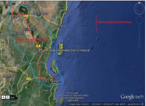
An algorithm is a procedure to accomplish a specific task. An algorithm is the idea behind any reasonable computer program. An algorithm is a procedure that takes into account any of the possible input instances and transforms them to the desired output[1]. Path similarity represents that many of the alternative paths derived from the k-shortest path algorithm are likely to share a lots of links, so they could not represent heterogeneity. The algorithm builds new path based on the degree of overlapping between each path and travel cost, and stops building when the degree of overlapping ratio exceeds its criterion[2]. This work has been done when we were developing a system for monitoring and reporting excessive passengers in public buses. The system detects when there is any event that compromises passengers’ safety such as overloading of passengers, over speeding or accidents and reports it to the concerned authorities. It then sends report to the next police station the bus will come across so they can take necessary actions. This study was conducted along Arusha to Dar es Salaam road in Tanzania. Eighteen different police stations were identified where report can be sent. Each station has a mobile number where the messages are sent. The public buses equipped with GPS which identifies its location and GSM which sends the coordinates to a database.
Figure 1: Arusha to Dar es salaam road (source: Google earth)
The Spherical law of cosines is used to spot the location of a police station closest to a public bus that has encountered an event such as accident, overloading of passengers or over speeding. This formula is used generally for Computing great-circle distances between two pairs of coordinates on a sphere[3]. Now to identify the location of the bus and where to send the report we invented an algorithm which can perform that task. To do this we have to know the three important parameters.
Route
Shortest distance
Nearest police station
We have different types of structures for algorithms. All have associate algorithm problem. This includes Trees, Graph, Points, and String[4]. In our case we are dealing with points, latitude and longitude. Many branches of mathematics have contributed to aspects of algorithm design, and the issues raised by the analysis of new algorithmic problems have in a number of cases suggested novel mathematical questions[5]. The spherical cosine rule is used to calculate the shortest distance between the location the public bus and police stations.
ROUTE
Route is one of the important parameters for this algorithm. The first thing is to identify the route of the public bus. The next police station will depend on its direction. If it is from Dar es Salaam to Arusha the next police station is different as when it is from Arusha to Dar es Salaam. Therefore before doing anything identification of the route is indicated and stored in the database. The database has the table for the route where it checks before identifying the nearest police station. The following is the geocode stored in the database for different police stations along Arusha to Dar es salaam Road. If the route is from Arusha to Dar the nearest police station will be in descending order from Geocode_ID 18 to 1 and if the Route is From Dar es salaam the next station will be in ascending order from Geocode_ID 1 to 18.
Figure 3: Police Stations along Arusha - Dar es Salaam road
SHORTEST DISTANCE
trigonometry: all other identities, including the sine rule, may be derived from the cosine rule.
C
b
a
b
a
c
B
a
c
a
c
b
A
c
b
bcoc
a
cos
sin
sin
cos
cos
cos
cos
sin
sin
cos
cos
cos
cos
sin
sin
cos
cos
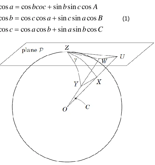
(1)Figure 4: Different triangle on spherical shape
We next calculate the length of the segment UW in the plane P using the Euclidean Law of Cosines applied to the triangle UZW.
Figure 5: Triangle ZWU
First, we need the length of the segments ZU and ZW. The length of ZU can be calculated by looking at the cross section of the sphere containing O, Z, and U.
Figure 6: Triangle BZU
Hence, the length of ZU is tan B and similarly, the length of ZW is tan A.
Thus,
cos
)
)(tan
(tan
2
2
)
(tan
2
)
(tan
cos
)
)(
(
2
)
(
2
)
(
2
)
(
A
B
A
B
lengthofZW
lengthofZU
W
lengtohofZ
lengthofZU
LengthofWU
..(2)Finally, we apply the Euclidean Law of Cosines to the triangle OWU. Note that the angle of UOW is C, which is our goal. First note that the length of OU is sec B from the above Figure, Similarly, the length of OW is sec A.
Thus,
C
SecA
B
A
B
C
lengthofOW
lenthofOU
lengthofOW
lengthofOU
lengthofWU
cos
)
)(
(sec
2
2
)
(sec
2
)
(sec
cos
)
)(
(
2
2
)
(
2
)
(
2
)
(
..(3)Equating the two expressions for (length of WU)
2
, we obtain,
C
A
B
A
B
C
A
B
A
B
A
B
A
B
cos
)
)(cos
(sec
2
2
2
)
(tan
2
)
(tan
cos
)
)(sec
(sec
2
2
)
(sec
2
)
(sec
cos
)
)(tan
(tan
2
2
)
(tan
2
)
(tan
……. (4)Where we used the Pythagorean identity (tan θ) 2 + 1 = (sec θ) 2 for the last step. Simplifying, we have
1
cos
)
)(sec
(sec
cos
)
)(tan
(tan
B
A
B
A
C
,...… (5)And cross-multiplying by (cosA)(cosB), we obtain
)
)(cos
(cos
cos
cos
)
cos
)
(sin
A
B
C
A
B
……... (6)Theorem (Spherical Law of Cosines)
cos
)
)(sin
(sin
)
)(cos
(cos
cos
C
A
B
A
B
………(7)Figure 7: Latitude and longitude received from the system for the current location of the bus
)
sin(
)
1
sin(
)
1
cos(
)
cos(
)
1
cos(
9
cos
*
LAi
LA
LO
LOi
LAi
LA
a
R
d
…. (8)
Where
d =is the distance between two coordinates.
R=Radius of the earth.
LA1 = Latitude of the current location of the bus.
LO1 = Longitude of the current location of the bus.
(LA1 and LO1 as shown in figure 7)
LAi = Latitude of the location of all police station along the road.
LOi = Longitude of the location of all police station along the road.
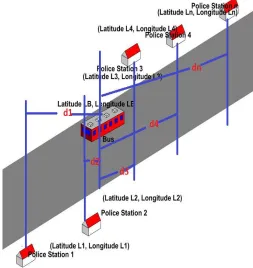
(LAi and LOi as shown in figure 3)
Figure 8: Different Station along the main road
NEAREST POLICE STATION
using System; using System.Data;
using System.Data.SqlClient; using System.Data.SqlTypes; using Microsoft.SqlServer.Server;
//INITIALIZING STATION ARRAY
station[0] = DAR; station[1] = KIBAHA; station[2] = MLANDIZI; station[3] = CHALINZE; station[4] = WAMI; station[5] = MKATA; station[6] = SEGERA; station[7] = KOROGWE; station[8] = MOMBO; station[9] = HEDARU; station[10] = SAME; station[11] = MWANGA; station[12] = HIMO; station[13] = MOSHI;
station[14] = BOMA_NGOMBE; station[15] = KIA;
station[16] = USA_RIVER; station[17] = ARUSHA;
//CALCULATING THE MINIMUM DISTANCE
for (i = 0; i < 18; i++)
{
distance[i] = di;
station = station[i];
}
minimum = distance[0];
for (i = 0; i < 18; i++)
{
if (minimum > distance[i])
{
minimum = dist[i];
}
}
//CHECKING THE NEXT POLICE STATION TO REPORT THE EVENT
if (Origin = DAR)
{
Station = Station[i + 1];
}
elseif (origin = Arusha)
{
Station = station[i - 1];
}
As discussed earlier, we need to identify the next police station to report the event. The code shows the first thing is to identify the route of the bus. The next step is to initialize the array for all the police stations along the road. Then calculate the distance from where the bus is located to the nearest police station. There after calculating the shortest distance then report to the next station for further action.
CONCLUSION
The paper demonstrates the calculation for the shortest distance from the location of the public bus to a nearest police station and one the bus will encounter next. Thereafter a report can be sent to both stations and proper actions can be put into effect. The algorithm has been tested on the 600 kilometers route from Dar es Salaam to Arusha in Tanzania for which the system was used for monitoring and reporting excessive passengers in public buses. The main objective was to identify the location of the bus where it overloaded the passengers and then send the report to the nearest police station for appropriate actions to be taken. The algorithm uses the spherical low of cosine.
REFERENCE
[1]. Skiena, S., The Algorithm Design Manual: Text. Vol. 1. 1998: Springer.
[2]. Yongtaek LIM, H.K., A shortest pah algorithm for real road network based on path overlap. Journal of the Eastern Asia Society for Transportation Studies, 2005.
[3]. Hasan, K.S., et al. Cost effective GPS-GPRS based object tracking system. in Proceedings of the International MultiConference of Engineers and Computer Scientists. 2009: Citeseer.
[4]. Alsuwaiyel, M., Design Techniques and Analysis. Algorithms, 1999. 10: p. 9789812386397_0009.
[5]. Kleinberg, J., The Mathematics of Algorithm Design.
[6]. Nikita Jaiswal, R.K.C., Increasing no. of nodes for Dijkstra algorithm without degrading the performance. International Journal Of Engineering And Computer Science, 2013.