REVIEW ARTICLE
Performance Analysis of Wireless Sensor Network
Localization Algorithms
Putri Kevin
Department of Computer Science, Brahijaya University, Indonesia.
[email protected]
Dian viely
Department of Computer Science, Brahijaya University, Indonesia.
[email protected]
Udeni T. Samarakoon
Department of Computer Science, Sri lanka Institute of Technology,
Srilanka.
[email protected]
Published online: 04 December 2019
Abstract –In recent years, the use of Wireless Sensor Networks (WSNs) has been increasing. Like WSNs protocols development, localization is the main issue and needed to address several areas including 3D and mobile anchor-based localization algorithms. WSNs are being used widely in different fields like environment, disaster relief, target tracking and several other applications like the SCADA system for the high voltage of electricity. In many applications, node localization is very important in which the system needed to know the exact location of the event. This paper addresses the main ideas and techniques published in recent years. We highlight the error performance analysis between the algorithms stated static 3D localization.
Index Terms – Wireless Sensor Network, Localization, RSSI, GPS, Ad-Hoc Network, Centroid, Distributed, Coordinate System.
1. INTRODUCTION
Wireless Sensor Network (WSN) is the main part of surveillance and monitoring. It can be used in many areas of the world and electronics. This is made by some self-contained materials that further used in different sensing environments like healthcare, military, and agriculture. The periodically reported changes or movement of animals, decrease or increase in temperature, rainfall, etc., are reported to aggregation point or central server [1]. The current study focusses on the literature of state-of-the-artwork published in recent years. The techniques of localization fall under two domains. One is range-based and the other is rage free localization. Range-based Localized uses estimated distance between two nodes by using the physical properties of the communicated signal. Range free Localization in WSN which is a common and cost-effective technique that computes range based on DV hop or DV distance. 3-D area detecting can be valuable up to some degree, however on the off chance that
the area designs are considered, at that point the errand aura can be reasoned. In any case, in light of prior comparable circumstances, vital advances must be thought about while chipping away at the present situation while remembering the results. In this way, it ends up important to construct a connection between the acting gadgets and the earth [2]. Think about a situation, where sensor arrange frameworks are produced for conduct investigation as far as execution and control. This can be conceivable if the sensor hubs are accessible at specific areas monitor activities or discover a connection between the articles, which are critical for legitimate administration and working.
Localization estimation is a key marvel in restriction procedure. It will evaluate the limitation framework's and calculation's elucidation. The information picked up from these strategies will be subject to various angles like system structure, connectedness, hub concurrence period and flag transmission limit. The estimations are far as time, control or graphically. For these all advantages, research on node localization is very important. Unfortunately, for large networks sensor nodes, some time requires to have a GPS unit on all the nodes makes the system more expensive and sometimes even impossible to deploy. The addition of GPS on all nodes is not feasible due to the following reasons [3].
In a dense environment, there might be some
buildings, mountains, and even dense forests. In that case, GPS never works because of the line of sight issue.
The use of a GPS receiver might low down the
REVIEW ARTICLE
For a large network system, the cost goes very high
if every node has a GPS.
Some nodes are very tiny and GPS antenna and
receiver are very high. So, the addition again impossible especially for mobile-based networks.
For the above-mentioned issues, we always need some kinds of localization solutions free from external hardware [4]. Several research ideas based on anchorless and anchor node, centroid vs distributed, and other solutions are presented in the literature. The paper organization is as follows: Section 2 and 3 describe the related work and problem formulation respectively. Section 4 describes the detail of range-based and range-free localization algorithms. Whereas Section 5 concludes the paper.
2. RELATED WORK
The main art of localization is to compute the sensor position by measuring the distance between two nodes. This is a very important phase in measuring the position of any sensor node. Based on the distance measurement of angle measurement the area of localization is subdivided into Range-based localization and Range free localization. [5-7]. Range-based techniques used to measure the distance between sensors through some signal strength measurement known as received signal strength indicator (RSSI) [5], Time of Arrival (ToA) [6], Time Difference of Arrival (TDoA) [7] and Angle of Arrival (AoA) [8]. In the RSSI system, the receiver sends signal strength concerning the sender and compute the distance based on signal strength. With proper time synchronization factor, TOA and TDOA calculate the range for localization by using anchor nodes [9]. GPS based localization is also a way to measure the sensor position [10] is another scheme of Range-based system which is so expensive and sometimes hard to implement. However, the indirect technique for localization is known as Range free Localization in WSN which is a common and cost-effective technique that computes range based on DV hop or DV distance. Some of the network scenarios for localization following are the main considerations for measurement techniques.
2.1. Graphical Scenarios: (topology constraints)
This situation gives the outline about the present sensor hub which demonstrates great execution with transmitted flag and data sharing should be possible inside the range, with appropriate mapping. Sensors in closeness to one another from a cluster. In this way, to get thought concerning the entry course estimation, the period of the transmitted flag is investigated, while if sensors are far separated, a whole number of inconvenience wins [11]. Topology construction for localization is very crucial. Because a localization algorithm must be compatible with all kinds of algorithms.
Usually, a C shaped localization topology is considered in most of the techniques. The reason is the movement of the mobile anchor towards the curve path is not easy. The mobile robot needed to program with the current path so that it can complete a random walk to cover the entire network area [12].
2.2. Time Consideration
This factor has a reliance on mark and sensor capacity. In this way, the exact time estimation nearness of unmistakable marks would be useful. Be that as it may, the primary criteria are mapping with the transmission or gathering hub. In this way, outright or relative separation can be seen relying upon the kind of mapping. Time is a very important factor [13]. Because if an algorithm does not complete its execution within a time frame the system can not respond to the application server and a node battery might go down. In this case, the complexity analysis of the localization algorithm must be considered before its implementation in a real scenario.
2.3. Power Consideration
This arrangement with finding the gathered flag's capacity inside a predefined extend for flag vitality estimation amid time break. This prompt run computation if control is accessible, on the other hand, the present sensors can correspond their flag control for gathered flag control figuring’s. A localization technique should be free from any extra hardware to avoid excessive power utilization [14].
2.4. Accuracy: (Localization error)
REVIEW ARTICLE
be delegated go free and range based. By and large, extend based methodology ascertains Internode separation and points utilizing range information. The acquired range information is giving better execution as far as separation counts, when contrasted with without range approach, though extend free manages relatedness forecast give authorization to every hub for deciding the number of hubs with radio extension.
3. PROBLEM FORMULATION
Considering a network with N sensor nodes at different location i.e. 𝐿 = 𝑙1, 𝑙2, 𝑙3, … , 𝑙𝑛. Suppose 𝐶𝑥1, 𝐶𝑦1, and 𝐶𝑧1 are
the coordinates of the node in a 3D space. There might be some nodes considering as an anchor node with the known position within the network. The reference node either be an anchor or a simple sensor node that will continuously be sent beacons to other nodes to achieve RSSI values. So, the network scenario can be represented mathematically as
follows: having multiple networks denoted by 𝜕 = (𝑉, 𝐸) and
a set of beacons to the node with their respective position for
all 𝐶𝑥1, 𝐶𝑦1, and 𝐶𝑧1. The ultimate solution is a node position for
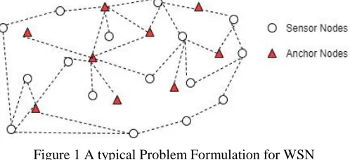
all the nodes within a network in cartesian coordinates forms. The anchor nodes also act as routing nodes that transform information between the network and an application server as shown in Figure 1.
Figure 1 A typical Problem Formulation for WSN Localization
4. 3D BASED LOCALIZATION ALGORITHM
Two types of localization algorithms are presented in the literature, range-based and range-free techniques.
4.1. Range-based Localization Algorithms
Primarily, range-based calculations hold distinctive
techniques for separation figuring like time and heading based flag quality-based methodologies. Likewise, to get an appropriate estimation of node situating multilateration or triangular methodology can be actualized. In this way, to acquire an exact separation or edge utilizing area information, expensive equipment is required. If the between node separate data is known, it is conceivable to acquire exactly between hub run, the base station in the hub zone and exact position calculation. However, due to non-uniform hub dissemination intricacies emerge in a system. In this way, the topology control approach is utilized by the age of connection
likelihood structure acquired from the measure of bundles at the recipient end. This urged to utilize the tantamount system going about as verification, to get lost between hub measurement on account of low thickness areas. In this way, in a two-dimensional situation for position figuring zone verification approach is utilized, where commonplace neighbors are given range estimation. In any case, for example, if hubs can't get go data, because of nonattendance of neighbors or have fewer neighbors all things considered network is the best methodology. As, in this methodology, the present hub has to go data from two neighbors, where area from k and k' are acquired regarding neighbors I and j individually. It is important to know out of k and k' which is genuine and non-existent hubs. Thus, the network will be the best arrangement. This methodology is drilled by following these means as discovering mapping information, figuring Packet gathering rate and changing to weight and network counts seriously and fanciful hubs qualification for between hub measurement estimations.
In [15] the node localization problem is considered as then optimization problem and a study based on the comparative analysis is conducted to evaluate the performance of the Micro-Differential Evolution algorithm. The proposed algorithm in [15] is comprised of the realistic terms for solving localization problems, where noises and estimated errors like strength signals are taken into consideration. The microevolutionary algorithms are used for this purpose as they always require less processing time. These algorithms are based on the small-sized population. The main limitation of the ME algorithm is that they cannot consider the diverse types of population, for overcoming this drawback a microevolutionary algorithm micro-differential evolution with scalar random mutation factor (MDESM) and micro-differential evolution with vectorized random mutation factor (MDEVM) is presented in [15].
The author in [16] presents a localization technique based on space distance interaction. It is a 3D localization algorithm in which every sensor node measures the distance by utilizing the mobile beacon. Mobile beacons are aware of their location using GPS and every beacon contains the current location of each mobile beacon. This algorithm presents a range base methodology so that mobile beacon can utilize the UBW signal. It provides an efficient resolution for time and is quite useful for multipath execution. For high accuracy, it utilizes TOA systems. Finally, SDI is proposed for determining the 3D position of the beacon node [16].
REVIEW ARTICLE
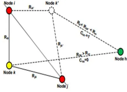
should be an occurrence of thickness subordinate bunching approach high thickness bunches are found, yet on the off chance that spatial grouping with commotion approach is connected, it will give insights about every hub recognizing center, clamor and outskirt focuses. In this way, for elite outcomes, separate restrictions and edge are the key parameters and all point examination is made dependent on them [17] as shown in Figure 2. RSSI has become a famous and applicable standard for wireless sensor networks due to its obvious features. A lot of researchers have applied RSSI based measurement algorithms in their research for location estimation. RSSI based localization techniques are cost-effective and do not require any additional hardware for their deployment, also they are cost-effective and do not have size issues related to them. That's the reason wireless sensor network communities are widely deploying this technique. RSSI based localization algorithms are distributed further into two further types named as distance estimation [18] and RSS profiling [19].
Figure 2. Grouping and Geometry of the WSN Network
A 3D localization technique is proposed in [20] which is based on the RSSI and free-ranging. Firstly, the technique measures the beacon nodes present in the neighborhood area by using RSSI and afterward acquires initial positional data of unknown nodes through territorial division. In last the technique redesigns the positional data through optimization iterations. Iterative streamlining can enhance location precision; however, the division of regions is effectively influenced by RSSI estimation errors.
A conceivable approach to significantly enhance the range accuracy may comprise some other methods like utilizing another physical layer rather than RSSI, for example, directional or multiple antennas or pressure waves. These solutions, however, are more demanding in terms of energy and require dedicated equipment, which increases overall deployment cost. Contrary to these other solutions,
immaculate RSSI techniques can be promptly deployed in each sensor system networks, following the fact that RSSI hardware is already supported by the majority of the current handset chipsets, with no additional equipment expenses. Hence, still, there is a ton of margin for improving the execution of RSSI–based location calculation algorithms. In this work, authors handle the issue by showing a precise execution analysis among some already existing RSSI–based location calculation algorithm in indoor situations. The main focus of the research is to highlight a superior comprehension of the real possibilities and limitations of these algorithms in indoor situations and to reveal insight into some open inquiries, for example,
1. What number of anchor nodes can minimize the error rate up to some defined level?
2. Do the Max-Min likelihood is much better in performance as compared to the simple Min-Max algorithm?
Overall the ML, Min-Max, ROCRSSI and Multilateration localization algorithms are compared in terms of performance. Two testbeds are created for this purpose. The first testbed is created by using 48 EyesIFX nodes. While the second testbed composed of one mobile node and 12 EyesIFX sensor nodes. Results presented show that ML performs better in the case when the number of anchor nodes is high. Multilateration localization algorithm is simple but its performance its even worst in both test cases and the same is true for the ROCRSSI algorithm. But Min-Max performs better as compared to the rest of the algorithms and is also cost-effective as it also can localize the stray nodes in the middle of the area [21].
4.2. Range-Free Localization Algorithms
The very well-known range-free localization scheme is presented in [22]. The first step of the proposed algorithm is to determine the distance estimations from the within range localized nodes and out of range localized nodes(for un-localized nodes distance estimation is obtained from the anchor node). These estimations are the radius of the circles present around the nodes. The intersection point between the circles generates the points for un-localized nodes which are used further for the implementation of this algorithm. The key point is to choose all those intersecting points which are closer to each other. In an ideal scenario, the points on the circle will intersect on the un-localized nodes. Intersection points encompassing anchor nodes p1 and p2 are denoted as p12 and p21. Every un-localized node can estimate its distance from the localized or anchor node from which it is receiving any signal. The result of the intersection between the two localize node or anchor nodes estimates will create a group based on the two points.
REVIEW ARTICLE
whose density is higher as compared to the mean density are selected as the candidate point. Overall the algorithm comprises three steps.
1. Distance estimation for the un-localized node from
anchors
2. Calculation of intersection points
3. Selection of candidate points based on the density,
where K-nearest neighbor technique is used for density calculation.
Performance results are compared with the LLS and WLS-SVD with the deployment of 100 nodes. Results show that the proposed algorithm selects the best distance estimated intersection points as compared to the rest of the algorithms [22]. In 2017 the author proposed an idea based on parametric loop division and B-spline function [23]. This paper was considered a well-known idea during the past few years. The idea behind the algorithm was to introduce a new parametric point that reduces the size of the area for localization. The performance analysis and lower bound was measured by using (1).
𝑙 =8𝜋0.955√𝑉2𝑚(𝐾+1) (1)
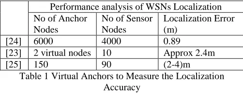
Pre-localized points are used in the analysis of localization error that is directly proportional to the volume of pre-localized nodes. Another idea was proposed in [10], where an author makes a roadway for coal mines. The model is also much similar to the PLD algorithm published in [24]. But here the idea introduces the DV mining technique to measure the localization error. They use some virtual anchors to measure the localization accuracy as shown in Table I.
Performance analysis of WSNs Localization No of Anchor
Nodes
No of Sensor Nodes
Localization Error (m)
[24] 6000 4000 0.89
[23] 2 virtual nodes 10 Approx 2.4m
[25] 150 90 (2-4)m
Table 1 Virtual Anchors to Measure the Localization Accuracy
In the paper [11], the author used the Cramer Rao lower bound that is very useful in finding the localization position. The error was supposed to be 2-4 m. and the author needs to improve the idea.
A linear approach based on localization is also another methodology to locate the position of the source node. At first, the Cramer Rao Lower Bound (CRLB) for location estimation is deduced and the four other linear methodologies known as Weighted Linear Least Squares (WLLS), Subspace Approach (SA), Linear Least Squares (LLS) and two phases Weighted Linear squares (WLS) is presented in the research.
LLS technique uses the least square method for
calculating the position of unknown node.
The subspace approach uses the TOA statistics in the
form of the matrix for calculating the position of the unknown node.
Weighted linear least square uses the weighted
symmetrical matrix for the calculation of the position of unknown node.
The mathematical model considered is
r =f (x)+ n
The distance between the kth sensor and source node denoted
by kd is presented by the Eq: for estimating TOA.
(2)
Based on the simulation study the results have been compared. Simulation is performed in MATLAB within the 2D environment for evaluating the comparison of linear localization algorithm. The two-step algorithm based on the WLS performs better in terms of location accuracy as compared to the rest of linear localization algorithms [25].
In [26] the customary range free DV-Hop technique is implemented into 3Dspace.
It is distributed into three stages:
1. Processing the minimum hop count between the bacon
nodes and unknown nodes. A mobile agent is utilized for localization. Mobile nodes recorded the directional coordinates of the beacon nodes and the total number of hops between two nodes. Nodes only retain the data of those mobile nodes whose hop counts are minimum and discard the rest of the data.
2. Error Estimation and Per-hop Distance Measurement: In
this step error calculation and the per-hop distance of beacon nodes are calculated. This value is broadcast over the network and an unknown node retains all the data related to the average per-hop distance of a beacon which it can get, and sent to the next neighbor of the nodes, then utilized this per-hop based calculation by using already saved information related to the hops.
3. Calculating the per-hop distance of unknown node: If
extended the DV-Hop calculation to the 3-D space basically, at that point the unknown node will initially save the firstly received average distance of the beacon node. So that only the latest data of the beacon node can utilize [26].
REVIEW ARTICLE
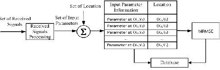
information the positions where they are made. To this end, a fingerprinting database containing RSSI measures for each reference node related to its position is built. The model is then characterized utilizing part techniques and built a database. At that point, to restrict the node, everyone gathers, while moving, RSSI measures at unfailingly step. These RSSI measures are utilized with the characterized model to assess the situation of the thought about nodes as shown in Figure 3 and figure 4.
(3)
Ultrawideband (UWB) frameworks offer high spatiotemporal goals and are along these lines appropriate to sensor confinement applications. In this paper, we consider the utilization of UWB signals for situating and extending dependent on fingerprinting utilizing a channel motivation reaction database. We utilize indoor estimations to exhibit the decrease in the area estimation vagueness and false caution likelihood with an increment in the channel transmission capacity [28].
(4)
(5)
In [29] they broke down the use of WSNs to situate with a fingerprinting strategy on the standard of IEEE802.15.4a (Ultra-wideband (UWB)) as far as the number of receiving wires required when utilizing viewable pathway (LOS) condition. The test was finished by utilizing a vector organize analyzer (VNA) with biconical radio wires. The recurrence exchange capacity of the channel was estimated in different areas. Therefore, the utilization of the defer time parameter of the UWB standard gave the best outcome. It could utilize just a single reception apparatus combine to distinguish regions precisely. Also, it spared time for doing the database, diminished the size of the database and decreased some expense because the number of reception apparatuses was diminished.
Figure 3: Fingerprinting in Online Mode
Figure 4: Fingerprinting in Offline mode
(6)
In [30] This work exhibits a decentralized limitation calculation that makes utilization of radio-area fingerprinting and portion strategies. The proposed calculation comprises separating the system into a few zones, every one of which having an adding machine fit for emanating, accepting and preparing data. By utilizing radio-data of its zone, every number cruncher constructs, by methods for part strategies, a model assessing the hubs positions. Mini-computers approximates are then joined together, leading to definite position approximates.
(7)
In [31], it has appeared although proliferation conditions for the picked ISM frequencies are diverse which results in various RF flag control appropriations, in the recreated condition the general exactness of IPS depending on RF fingerprinting calculation stays at comparative dimensions. Be that as it may, after closer assessment of CDF capacities determined for separate regions of the scene one could find that precision of every one of recurrence varies relying upon the zone.
REVIEW ARTICLE
5. CONCLUSION
In this paper, we review some well-known algorithms based on 3D static networks. Most of the algorithms presented in this paper are based on ideas with high precision and accuracy. We have analyzed that a localization network can be: static node and static anchor-based, mobile anchor and static nodes, mobile anchor and static sensor and both mobile. We have summarized mobile landmarks and mobile nodes localization algorithms in the aspect of localization accuracy, localization coverage, localization time, landmark number and energy consumption. The work is still in progress and the next work, we are going to present some mobile-based and mobile anchor-based localization algorithms.
REFERENCES
[1] Ukani, V., Thakkar, P., & Parikh, V. (2019). A Range-Based Adaptive and Collaborative Localization for Wireless Sensor Networks. In Information and Communication Technology for Intelligent Systems (pp. 293-302). Springer, Singapore.
[2] Ahmad, T., Li, X. J., & Seet, B. C. (2016, May). 3D localization based on parametric loop division and subdivision surfaces for wireless sensor networks. In Wireless and Optical Communication Conference (WOCC), 2016 25th (pp. 1-6).
[3] Yan, J., Qiao, R., Tang, L., Zheng, C., & Fan, B. (2019). A fuzzy decision-based WSN localization algorithm for wise healthcare. China Communications, 16(4), 208-218.
[4] Supate, K., Bhosale, S., & Student, M. E. (2019). RSSI Based Indoor Localization of WSN Sensor Nodes. International Journal of Engineering Science, 21479.
[5] L. Girod, D. Estrin, Robust range estimation using acoustic and multimodal sensing, in Proceedings 2001 IEEE/RSJ International Conference on Intelligent Robots and Systems, Expanding the Societal Role of Robotics in the Next Millennium (Cat. No.01CH37180), vol. 3, pp. 1312–1320.
[6] X. Cheng, A. Thaeler, TPS: A time-based positioning scheme for outdoor wireless sensor networks, in the 23rd IEEE International Conference on Computer Communications, 2004, INFOCOM 2004, vol. 00(C), pp. 2685–2696.
[7] T.S. Rappapport, Wireless Communications: Principles and Practice, seconded. Prentice Hall, New Jersey, 1996. pp. 50–143
[8] D. Moore, J. Leonard, D. Rus, S. Teller, Robust distributed network localization with noisy range measurements, in Proceedings of the Second ACM Conference on Embedded Networked Sensor Systems (SenSys '04), Baltimore, MD. November 3–5, 2004
[9] L. Doherty, K. Pister, and L. Ghaoui, “Convex Position Estimation in Wireless Sensor Networks,” Proceedings of the 20th Annual Joint Conference of the IEEE Computer and Communications Societies (INFOCOM 2001), Apr 22-26, 2001.
[10] N. Bulusu, J. Heidemann, and D. Estrin, “GPS-less low-cost outdoor localization for very small devices”, IEEE Personal Communications Magazine, 7(5):28–34, October 2000.
[11] Wang, Feng, Lei Shi, Weiguo Fan, and Cong Wang. "Application of computational geometry in coal mine roadway 3D localization." Int. Arab J. Inf. Technol. 15, no. 4 (2018): 668-674.
[12] Parras, J., Zazo, S., Pérez-Álvarez, I. A., & Sanz González, J. L. (2019). Model Free Localization with Deep Neural Architectures by Means of an Underwater WSN. Sensors, 19(16), 3530.
[13] Kouroshnezhad, S., Peiravi, A., Haghighi, M. S., & Zhang, Q. (2019). A mixed-integer linear programming approach for energy-constrained mobile anchor path planning in wireless sensor networks localization. Ad Hoc Networks, 87, 188-199.
[14] Kouroshnezhad, S., Peiravi, A., Haghighi, M. S., & Zhang, Q. (2019). A mixed-integer linear programming approach for energy-constrained
mobile anchor path planning in wireless sensor networks localization. Ad Hoc Networks, 87, 188-199.
[15] Zheng, J., Liscano, R., Aghababaei, S., Chepurna, I., & Eklund, M. J. (2019). Improving Localization in Sensor Networks by Leveraging Inter-node Ranking of Received Signal Strength and Clustering. Adhoc & Sensor Wireless Networks, 44.
[16] Parulpreet, S., Arun, K., Anil, K., & Mamta, K. (2019). Computational Intelligence Techniques for Localization in Static and Dynamic Wireless Sensor Networks—A Review. In Computational Intelligence in Sensor Networks (pp. 25-54). Springer, Berlin, Heidelberg. [17] Wen-Chen Hu, Naima Kaabouch, Sara Faraji Jalal Apostal, Hung-Jen
Yang,” Aware Mining for Privacy-Preserving Location-Based Advertising”, IEEE 2017, pp. 569-574.
[18] Kaur, A., Gupta, G. P., & Mittal, S. (2020). Impact of Nature-Inspired Algorithms on Localization Algorithms in Wireless Sensor Networks. In Nature-Inspired Computing Applications in Advanced Communication Networks (pp. 1-18). IGI Global.
[19] Kovner, R., Souaiaia, T., Fox, A., Roseboom, P., French, D., Oler, J., ... & Kalin, N. (2019). 208. Transcriptional Profiling of Primate Central Nucleus of the Amygdala Neurons: A Role for PKCd Neurons in Early Life Anxious Temperament. Biological Psychiatry, 85(10), S86.
[20] A Decentralized Positioning Method for Wireless Sensor Networks Ba sed on Weighted Interpolation C. -L. Wang; Y. -W. Hong; Y. -S. Dai 2007 IEEE International Conference on Communications Year: 2007 Pages: 3167 – 3172.
[21] Giovanni Zanca, Francesco Zorzi, Andrea Zanella, and Michele Zorzi,(2008)Experimental comparison of RSSI-based localization algorithms for indoor wireless sensor networks, Department of Information Engineering University of Padova, Italy
[22] Shi, P., Li, G., Yuan, Y., & Kuang, L. (2019). Outlier Detection Using Improved Support Vector Data Description in Wireless Sensor Networks. Sensors, 19(21), 4712.
[23] Ahmad, T., Li, X. J., & Seet, B. C. (2019). Noise Reduction Scheme for Parametric Loop Division 3D Wireless Localization Algorithm Based on Extended Kalman Filtering. Journal of Sensor and Actuator Networks, 8(2), 24.
[24] Ahmad, T., Li, X., & Seet, B. C. (2017). Parametric loop division for 3d localization in wireless sensor networks. Sensors, 17(7), 1697. [25] Mohsen Jamalabdollahi & Seyed A. Reza Zekavat. (2015).Joint
Neighbor Discovery and Time of Arrival Estimation in Wireless Sensor Networks via OFDMA, IEEE Sensors Journal (Volume:15, Issue: 10 ).pp:5821 – 5833.
[26] Wang, L., Zhang, J., & Cao, D. (2012). A new 3-dimensional DV-hop localization algorithm. Journal of Computational Information Systems, 8(6), 2463-2475.
[27] Sandy Mahfouz, Farah Mourad-Chehade, Paul Honeine, Hichem Snoussi, Joumana Farah, "Kernel-based localization using fingerprinting in wireless sensor networks" Workshop on signal processing Advances in wireless communications,2013, pp.744-748. [28] Wasim Q. Malika, Ben Allen,” Wireless Sensor positioning with
Ultrawideband fingerprinting”.
[29] Wipassorn Vinicchayakul, Sathaporn Promwong, and Pichaya Supanakoon," Study of UWB Indoor Localization Using Fingerprinting Technique with Different Number of Antennas", IEEE 2016.
[30] Sandy Mahfouz, FarahMourad-Chehade, Paul Honeine, Joumana Farah, HichemSnoussi,”decentralized localization using fingerprinting and kernel methods in sensor networks”, EUSIPCO 2013, pp.1-5. [31] Przemyslaw Woznica, Lukasz Kulas,” Influence of a Radio Frequency
on RF Fingerprinting Accuracy Based on Ray Tracing Simulation", EuroCon 2013, pp.202-206.
REVIEW ARTICLE
[33] Ahmad, Tanveer, Xue Jun Li, and Boon-Chong Seet. "3D Localization Using Social Network Analysis for Wireless Sensor Networks." 2018 IEEE 3rd International Conference on Communication and Information Systems (ICCIS). IEEE, 2018.
Authors
Putri Kevin is a graduate student of Brahijaya Universality. His research interested included wireless communication and wireless sensor networks optimization. Currently, he is researching localization and routing of WSNs.
Dian Viely is a senior researcher in Kadam ltd Malaysia. Her research interested included wireless sensor networks, healthcare systems, and SCADA optimization.