228
REGULAR GEOMETRY TOWARDS EFFECTIVE VISITORS WAYFINDING: A CASE STUDY OF KLCC VICINITY
HOSSEIN SAFARI
A thesis submitted in fulfilment of the requirements for the award of the degree of
Doctor of Philosophy (Architecture)
Faculty of Built Environment Universiti Teknologi Malaysia
iii
To my lovely wife, Fataneh Fakouri Moridani. Without her love, patience, encouragement, and support unreservedly
given , it would have been impossible to complete this research.
I also remain deeply indebted to my beloved mother Zahra Abhari Khoshdel, my beloved father Yaghoub Safari
Syahgourabi, and to my children Farjad and Farsad.
I dedicate this work to them and express my thanks to them for their love, patience and support unreservedly given.
To my brother, Reza Safari, thank you for encouragement as well as support and wishes.
iv
ACKNOWLEDGCMENT
BismillahirRahmanirRahiim. Assalamualaikum wmt wbt
Thanks be to Allah, the Most Benevolent and the Most Merciful, and Who made the pursuit of knowledge obligatory upon all His Believers. It was only in the pursuit of His pleasure that this work was undertaken. It is my hope that this work may contribute an iota of advancement to mankind in order to understand His knowledge.
I am gratefully indebted to my Supervisor, Dr. Sharifah Salwa Binti Syed Mahdzar. Her encouragement, dedication and expert guidance in formulating the issues and research approach towards the completion of this thesis, especially when the goings becomes very tough, were beneficial and inspirational.
A huge debt is owed to many people in the local authorities who gave their time unsparingly and for giving me access to materials and information vital to this research.
v
ABSTRACT
vi
ABSTRAK
vii
TABLE OF CONTENTS
CHAPTER TITLE PAGE
DECLARATION ii
DEDICATION iii
ACKNOWLEDGCEMENTS iv
ABSTRACT v
ABSTRAK vi
TABLE OF CONTENTS vii
LIST OF TABLES xiii
LIST OF FIGURES xv
LIST OF ABBREVIATIONS xix
LIST OF SYMBOLS xx
LIST OF APPENDICES xxi
LIST OF GLOSSARY xxii
1 INTRODUCTION 1
1.1 Introduction 1
1.2 Background of the Study 2
1.3 Statement of the Problems 3
1.4 Aim of Study 5
1.5 Objectives of the Study 6
viii
1.7 Hypotheses of study 7
1.8 Operational Framework of Study 9
1.9 Significance of the Study 10
1.10 Scope of the Study 11
1.11 Thesis Structure 12
2 GEOMETRY AS A WAYFINDING ELEMENT 14
2.1 Introduction 14
2.2 Identify Geometry 18
2.3 Semantic Representation of Geometry 19
2.4 Islamic Architecture 20
2.5 Concepts Influencing Architectural Design 22
2.6 Geometric Expression in Architecture 24
2.7 Regular Geometry in Architecture 28
2.8 Concepts Expressed in Islamic Architecture 29
2.9 Geometry as the Two Dimensional Cue for Urban
Space Knowledge 29
2.10 Reducing Urban Stress by Regular Geometry and
Viable Cognitive map 31
3 STRESS AND COGNITIVE FUNCTION 32
3.1 Significance of Stress 32
3.2 What is Stress? 33
3.3 Effect of Green Spaces on the Urban Stress 34
3.4 Nature and the Power of Restorative 36
ix
4 EFFECTIVE ELEMENTS OF URBAN SPACE
CONFIGURATION IN WAYFINDING 39
4.1 Legibility as a Fundamental Principal in Urban Design 39
4.1.1 Elements of Legibility 39
4.1.2 Identify and Assess Legibility 41
4.1.3 Legibility Perception of Urban Space 43
4.2 The Identification Cognitive map in Wayfinding 44
4.2.1 Significance of Cognitive map in Wayfinding 44
4.2.2 Definition of the Cognitive map 45
4.2.3 What Is the Relationship between Cognitive
map and Wayfinding? 47
4.2.4 Elements of the Cognitive map Based on
Representation in the Mind 48
4.2.5 What Is the Relationship between Stress and
Cognitive map? 49
4.3 Landmarks as three dimensional cues for knowledge
about urban spaces 51
4.4 Effective Wayfinding and the Role of Urban Space
Configuration 52
4.4.1 Studies Investigating in Wayfinding 52
4.4.2 Role of Geometry in Wayfinding 53
4.4.3 Effective Wayfinding by Viable Cognitive
map 53
4.4.4 Relationship between Configurations of Space
with Wayfinding 54
4.4.5 Square as a Geometric Landmark 55
4.4.6 Approach to Sociability and Accessibility in Urban Space
59
x
5 METHODOLOGY 61
5.1 Introduction 61
5.2 Explanatory Design Study 61
5.2.1 Definition of Explanatory Design Study 61
5.2.2 Participants of study 62
5.2.3 Ethics statement 63
5.2.4 Data collection 63
5.2.5 Measures of quantitative phase 64
5.2.6 Testing On the Assumption of Normality 65
5.2.7 Qualitative phase 68
5.2.8 Analysis of the Data 70
5.3 Space Syntax by Depthmap Software 71
5.3.1 Background and Significance of Space Syntax 72
5.3.2 Why Was Space Syntax used in Architecture
and Urban Design? 73
5.3.3 Definition of Space Syntax Methodology and Principle Elements that Use in It 74
5.3.4 Case study 76
5.3.5 Measures and Procedure in Intelligibility
Study 77
5.4 Observations of Pedestrian Static and Dynamic
Activities 79
5.4.1 Empirical Observation of Static and Dynamic
Pedestrian Activities 79
5.4.2 Gate Observation 80
5.4.3 People Following 80
xi
5.4.5 Static Snap Shot 82
5.5 Summary 83
6 RESULTS AND DISCUSSION 85
6.1 Socio-Demographic Profile of Respondents 85
6.2 Value of Geometry to Legibility and Cognitive map 85
6.3 Impact of Regular Geometry on Cognitive map and
Urban Stress 94
6.4 Analyzing and Comparing Hypothetical Model and
Existing Space by Space Syntax 104
6.5 Analysing and Comparing Square Model in KLCC
and An Existing Street-only Network 109
6.6 Syntactical Analysis on Accessible and Sociable with
Square as a Regular Geometry 120
6.6.1 Gate Observations 121
6.6.2 People Following Observation 124
6.6.3 Directional Splits 126
6.6.4 Static Activities Observation 127
6.6.5 Result of the Empirical Axial Line by Space
Syntax 130
6.7 Summary 136
7 CONCLUSION 137
7.1 Introduction 137
7.2 The Role of Regular Geometry on Legibility 138
7.3 The Role of Regular Geometry on Cognitive map and
Stress 139
7.4 Consideration for Square as a Regular Geometry in
xii
7.5 Implication of Study 141
7.6 Recommendation 142
7.7 Research Contributions 143
7.8 Suggestions for Further Research 144
REFERENCES 146
xiii
LIST OF TABLES
TABLE NO. TITLE PAGE
2.1 Literature review of geometry 16
2.2 Literature review of stress 16
2.3 Literature review of legibility 17
2.4 Literature review of cognitive map 17
5.1 A description of the scale used to measure the three
elements that can affect legibility 64
5.2 A description of the scale used to measure the three
elements that can affect the cognitive map 65
5.3 Normality Test for Cognitive map 66
5.4 Normality Test for Legibility 66
5.5 Normality Test for Stress 67
5.6 Normality Test for Regular geometry 67
5.7 Normality Test for Existing geometry 68
5.8 Brief report of methodology 84
6.1 Socio-demographic profile of respondents 85
6.2 Visitors perception of the legibility of KLCC (n=86) 87
6.3 opinion of visitors regarding the legibility and effective
categories base on male and female participants 87
6.4 Means and standard deviations for responses about the
legibility of KLCC for various lengths of visits 87
xiv
90
6.6 Reasons for urban stress in the vicinity of KLCC (n=86) 95
6.7 Opinion of visitors regarding the cognitive map, effect of existing geometry and stress based on gender 95
6.8 Mean and standard deviations for responses about the cognitive map and stress in the vicinity of KLCC for various lengths of visits
96
6.9 The frequencies and percentages of coding of themes and
sub-themes 99
6.10 Data of vicinity of KLCC base on an analysis using
Space syntax 106
6.11 Characteristics of Street surround of KLCC-existing
Street 114
6.12 Characteristics of Street surround of KLCC-with square
suggestion model 115
6.13 Comparing Gate observation and configuration of street
in vicinity of KLCC 123
6.14 Socio-demographic profile of participants observed by
people following 124
6.15 Total density of visitors at weekend and weekday at
junctions 1, 2 and 3 127
6.16 Static Activities in KLCC Park 129
6.17 Syntactic measures of Streets connected to KLCC Park in
xv
LIST OF FIGURES
FIGURE NO. TITLE PAGE
1.1 Framework of relationship between legibility and
configuration knowledge 7
1.2 Framework of relationship between cognitive map,
geometry and stress 8
1.3 Framework of relationship between configuration of
urban space and effective wayfinding 8
1.4 Operational framework of study 9
2.1 Conceptual framework 15
2.2 Shaykh-Lutf-Allah mosque, Isfahan, 1601–1628 A.D 21
2.3 Auljaytu the Mihrab in the great Mosque of
Isfahan-1310 A.D 22
2.4 The process from circle to regular complexity geometry 24
2.5 Islamic-Iranian Golden ratio 25
2.6 Regular geometry in architecture 26
2.7 Regular geometry under the dome of the mosque 27
2.8 Roundel forms 27
2.9 Under the Dome of Shaykh-Lutf-Allah mosque,
Isfahan, 1601–1628 A.D 29
3.1 Natural factors affecting on stress reducing 35
3.2 Three behavioural mechanisms which decrease stress
xvi
3.3 Relationship between stress and cognitive function 38
4.1 (a1, a2) Vatican City. Peter’s Square; (b1,b2)Quenching Square,China;(c1,c2)Scholossplatz,Stuttgart,Germany, Castle Square;
56
4.2 Kuala Lumpur City Centre (Author) 58
5.1 Kuala Lumpour City Centre –KLCC 77
6.1 The general relationship between the legibility and
regular geometry of urban spaces in generally 89
6.2 The relationship between legibility and existing
geometry in KLCC 89
6.3 The relationship between the cognitive map and urban
stress 97
6.4 The relationship between the cognitive map and existing
geometry of vicinity of KLCC 98
6.5 The relationship between cognitive map and regular
geometry in general 98
6.6 (A) Urban patterns and conventional graph (existing map); (B) Urban patterns and topological relations
(Hypothetical model) 105
6.7 Ref numbers of (A) (existing map) and (B)
(Hypothetical model) 106
6.8 comparing the integration of the existing model and
hypothetical model 107
6.9 Correlation integration and connectivity C– existing
model; D-hypothetical model 107
6.10 KLCC Park (Author) 109
6.11 KLCC map with square suggestion 110
6.12 Left-Integration (HH)-Kuala
Lumpour-KLCC(R=10km)-existing Street, Right-Integration (HH)-Kuala Lumpour-KLCC(R=10km)-Suggestion
xvii
6.13 Ref Number 111
6.14 Left-Connectivity-KLCC-existing Street, Right -
Connectivity-KLCC- Suggestion Square 111
6.15 Left-Integration(HH)-KLCC-existing Street, Right-
Integration(HH)-KLCC-Suggestion Square 112
6.16 Left-Integration (HH)R2-KLCC-existing Street, Right-
Integration(HH)R2-KLCC-Suggestion Square 112
6.17 Left-Integration (HH)R3-KLCC-existing Street,
Right-Integration(HH)R3-KLCC-Suggestion Square 112
6.18 Left (existing street) and Right (suggestion model),
integration (HH) of street of remarked in Figure 4. 13 118
6.19 Scatter plot of relationship between local and global
Integration, A1-existing model, A2-suggestion model 118
6.20 Scatter plot of correlation between integration and
choice, a1-existing model, a2-suggestion model 119
6.21 Kuala Lumpur –KLCC(R=10km) 120
6.22 Gate Observation Map of vicinity of KLCC 121
6.23 Axial line analysis, Integration (HH) 121
6.24 Total density of movement for Gate Observation during
weekdays and weekends between Gate 1-22 122
6.25 Comparing local (R2 and R3) and global (Rn)
Integration (HH) in the vicinity of KLCC 124
6.26 Simulation of pedestrian movement in KLCC Park 125
6.27 People following In KLCC Park (Author) 125
6.28 Numbers and percentages of movement flows at
junctions 1, 2 and 3 126
6.29 Close up view of the map for zones A, B, C, D, E, F, G,
xviii
6.30 Images of each of the eight zones in the KLCC Park 129
6.31 Syntactic analysis of existing and square suggestion
model 131
xix
LIST OF ABBREVIATIONS
MDBC - Malaysian Dutch Business Council
KLCC - Kuala Lumpur City Centre
SPSS - Statistical Package for the Social Sciences
UNWTO - World Tourism Organization
H - Hypotheses
CVK - Configuration of Vicinity of KLCC
RG - Regular Geometry
IG - Irregular Geometry
EF - Effective Wayfinding
RQ - Research Question
Fr - Frequency
Fr(M) - Frequency of more than three weeks
Fr(F) - Frequency of fewer than three weeks
Fr(T) - Frequency of total
xx
LIST OF SYMBOLS
N - number of nodes in the space syntax graph
K - the shortest depth from i to k
Mdepth - Mean depth map
R - Integration
Rn - Global scale integration (Radius=10KM in this study)
R2 - Local scale integration (Radius=2KM)
R3 - Local scale integration (Radius=3KM)
N - Number
M - Mean
SD - Standard Deviation
p(p-value) - Significance level
F(F-test) - Statistical test in which the test statistic has an F- distribution under the null hypothesis
ANOVA - Analysis of variance
% - Percentage
T-Test - A method of statistical inference using data from a scientific study
xxi
LIST OF APENDICES
APPENDIX TITLE PAGE
A QUESTIONNAIRE FORM 177
B INTERVIEW FORM 181
C Summary reports of questionnaire 184
xxii
LIST OF GLOSSARY
Accessibility - In Space Syntax, accessibility is defined by integration which is determined as nearness centrality from origin to destination.
Axial map
analysis - Axial map analysis explains the behaviour of people into a pattern of urban spaces. This method illustrates social urban space analysis and treatment of people together by computer simulation
Cognitive
map - Cognitive map is an internal representation of what visitors have perceived from the environment
Connectivity - Connectivity means the number of streets that are connected to a Specific Street.
Depth - Depth is stated as the number of steps to reach all other nodes from node i in the space syntax graph.
Geometry - Geometry is a framework that allows elements to be organized and arranged into a pattern. It also shows the relationship between elements.
Integration - Integration shows how many turns have to be made from an origin to reach all other destination in the city, using shortest routes.
Intelligibility - Intelligibility is the degree of perception of the environment that is directly related to legibility.
Legibility - The legibility of a route is the ease with which a route can become known or how easily people can understand it.
Space syntax - Space syntax is a method for reading urban spaces which is an association between physical structure and social structure.
Synergy - Correlation between local integration and global integration is called synergy.
1
CHAPTER 1
INTRODUCTION
1.1 Introduction
Wayfinding follows psychological patterns using perception (Emo et al., 2012). External information of urban space such as environmental configuration may affect wayfinding decision making (Conroy, 2001). Evidence has shown that impaired wayfinding effect on visitors includes disorientation. Disorientation involves the egocentric spatial sphere, representation of heading, lack of landmark and viable cognitive function agnosia ( Bottoni et al., 1990; Suzuki et al., 1998; Aguirre and D'Esposito, 1999; Asselena et al., 2005). Visitors rely on certain wayfinding which might be a stressful experience when people are in an unfamiliar environment (Hölscher et al., 2006).
City centres have traditionally attractions for both international and local visitors. Urban areas provide a series of tourism and travel related attractions that are varied in nature but highly focused in location. City centres offer exceptional chance for visitors whose main purpose is meeting other people or institutions .Their purpose of visit might be different for business or leisure or personal (Vandermey, 1984) .Because of high potential of visitors for connecting people, mixed cultures and experiences with place and consumption, it must create an exciting and excellent exploration for visitors without stress (Edwards, Griffin et al., 2008).
2
factors. Tóth and Dávid (2010) called the accessibility as a key element for visitors in city. In other hand, the studies related to accessible urban tourism (Darcy and Dickson, 2009; Tóth and Dávid, 2010; Hano, 2011; Więckowski, Michniak et al., 2014) have focused mostly on transportation accessibility and accessibility for disabled , elderly and children in cities from touristic perspective. Wayfinding is another key element for visitors of urban areas.
Wayfinding is purposeful movement to a specific destination (Golledge, 1999). Humans use two strategies in wayfinding: Euclidian geometry as direction and distance estimates associated with cognitive map (Golledge, 1999, Kitchin and Freundschuh, 2000) and use landmark strategy (Burgess, 2006). Xia, Arrowsmith et al. (2008) Highlights that visitors apply different methods for wayfinding and urban managers should offer complementary materials to help them in wayfinding.
In search for an appropriate urban theory to help urban regeneration for assisting the visitors in urban areas, we may consider different theories of urban researchers in 21th century. The desired theory for this purpose should have significant role in urban design and regeneration.
The variables used in this study are physical properties and characteristics of vicinity of KLCC (e.g. geometry, integration, connectivity, choice, intelligibility and synergy) and psychological properties (legibility, cognitive map and urban stress).
1.2 Background of the Study
3
Early wayfinding research ( Mallot and Basten, 2009; Wiener et al., 2009; Vilar et al., 2013) focused on general characteristics and role of landmarks ( Caduff and Timpf, 2008; Zakzanis et al., 2009). Other wayfinding-related research includes studies based on age ( Head and Isomc, 2010; Newcombe et al., 2010), gender ( Mueller et al., 2008; Chen et al., 2009; Piccardi et al., 2011) of wayfinder, variety of materials, colour ( Spence et al., 2006), or on interior space such as airports, shopping malls, galleries (Lam et al., 2003). Despite these works, the literature is almost silent on unfamiliar urban space and their relationship with the spatial behaviour of tourists as visitors (Edwards and Griffin, 2013).
Much research has focused on the role of stress on the cognitive map ( Pruessner et al., 2010; Allen et al.,2013; Schwabe and Wolf, 2013;). In wayfinding, cognitive map have been studied in geometry and stress ( Lee et al., 2012; Mohsenina and Sevtsukb, 2013; Schwabe and Wolf, 2013). Although researcher’s focus on cognitive map (Weisman, 1981; Ga¨ rling et al., 1986) and wayfinding ( O'Neil, 1991a; O'Neil, 1991b) has increased lately, a review of space-syntax method(Karimi, 2012) for reading urban spaces, based on wayfinding literature, reveals relatively little theoretical work in the area. In other hand, geometry was only used in experiments on rats to determine the impact of geometry on wayfinding (Yaski and Eilam, 2007; Yaskia et al., 2011; Yaski et al., 2012). The current study attempts how wayfinding influences by geometry and how it affects urban stress.
1.3 Statement of the Problems
Evidence has shown that legibility, cognitive map and Geometry as effective elements of urban space affect wayfinding but there is little investigation about these elements of urban space simultaneously on wayfinding.
4
have an incomplete picture of how to improve cognitive mapping of visitors in urban spaces and as a result reduce their stress.
Geometry can create a variety of unseen forms. Regular geometry is effective in human navigation (Lee et al., 2012). Irregular geometry in today's urban space, especially developed cities and cosmopolitan areas has a negative influence on viable cognitive map. On the other hand, wayfinding is difficult to confront.
Golledge (1999) stated that cognitive mapping has a very important role in wayfinding. Cognitive mapping is fundamental to wayfinding. He also stated that it is the internal representation of the environment and the perception of them. A study on cognitive mapping is how information gathered from the environment and perception are used to make decisions when approaching destinations in daily life (Hong, 2007). Wayfinding is based on completing the internal representation of relationship between spaces as cognitive map (Allen,1999). Cognitive map affect our daily life for wayfinding. Human navigation involves reaching destinations with increased perception (Hölscher et al., 2011). Unfamiliar environment and lack of human scale in a development city are affected by negative cognitive map.
Legibility is a kind of comfort that includes identifiable paths (Lynch, 1960). A legible city is defined as an area which it has landmarks or routes as part of the configuration of urban space that are known easily understood and can be grouped easily in all patterns (Lynch, 1960).
The physical structure of built environment can shape legibility of urban space and human behaviour. Regular and coherent physical configuration of urban space affects the ease with which routes can be recognized in all environments but irregular structures result in difficult perception (Yaski et al., 2012). Regular geometry of urban space can make routes legible. However, an irregular urban space with an impressive dominant landmark can be legible (Yaski et al., 2012).
5
et al., 1998; Etienne, 2003). On the other hand, regular geometric design may differ from the urban design used in the development of a city (Lee et al., 2012).
Lack of proper wayfinding in unfamiliar space, and beyond the human scale of developed city, creates stress for visitors. Stress can be beneficial in the short term for humans but it is harmful and can cause serious illness if the body does not have a chance to rest (Atkinson et al., 1996). Research has shown that stress, irritation and fatigue are very closely related (Kaplan, 1990; Dinan, 1996; Klingberg. and Larson, 2001; Grahn and Stigsdotter, 2003).
Grahn and Stigsdotter in 2003 observed that in modern society stress and stress-related diseases are a common ailment of all people. In the twentieth century, architects began to include consideration of public health standards in their designs. Western planners in towns and cities also began to consider plans that reduced stress in individuals (Grahn and Stigsdotter, 2003). Research has shown that the human body involuntarily responded to natural elements and health effects but artefacts of elements such as residential or commercial towers and streets, especially with today's streets that are designed for cars solely, do not have a positive impact on human health (Ulrich, 1984, 1993, 1999).
1.4 Aim of Study
The goal of this study is to identify the importance of the geometry of urban space on legibility and to discover how it effects the cognitive map of visitors in the vicinity of Kuala Lumpur City Centre, enabling visitors to overcome the difficulty of urban stress due to wayfinding. For this aim, a twofold purpose is defined:
6
ii. The study evaluates and compares of wayfinding behaviour by observation and simulation; that is, the effects of square suggestion on factors such as accessibility and sociability because the existing space of KLCC Park on cognitive map and wayfinding varies within and across configuration of space.
1.5 Objectives of the Study
More specifically, this study aimed to achieve the following specific research objectives:
i. To investigate the relationship between cognitive map, legibility and geometry
ii. To identify effects of regular geometry on cognitive map and urban stress
iii. To compare the relationship between spatial syntactical variables and accessibility of streets in existing and square suggestion model
1.6 Research Questions
i. What is the relationship between legibility, cognitive map and geometry?
ii. What is the implication of regular geometry on cognitive map and urban stress?
7
1.7 Hypotheses of study
Regular geometry and unity of design affect the legibility of urban space helping to form a viable cognitive map. Moreover, wayfinding for locals and visitors in the city will be easy thus reducing the stress of visitors in an unfamiliar space. This will be illustrated in terms of the framework.
• Regular geometric and coherent design affects legibility of urban space. (Figure 1.1)
Figure1. 1 : Framework of relationship between legibility and configuration knowledge
• There is a positive relationship between regular geometry and viable cognitive map for visitors. (Figure 1.2)
• Regular geometry can reduce the stress of visitors in an unfamiliar space by ease of wayfinding. (Figure 1.2)
Ability to
recognize
landmarks = 3D
8
Figure1. 2 : Framework of relationship between cognitive map, geometry and stress
Regular geometry may help to configure urban space for ease of wayfinding. (Figure 1.3)
CVK: Configuration of vicinity of KLCC; RG: Regular Geometry; IG: Irregular Geometry; EF: Effective Wayfinding
Is formed with difficulty
Is formed with easy H1- Gender
H2-Length of time
H4, 5- Geometry
Figure1. 3: Framework of relationship between configuration of urban space
9
1.8 Operational Framework of Study
Figure 1. 4 : Operational framework of study
10
1.9 Significance of the Study
For different reasons, everyone has experienced disorientation and lack of recognition of environment and has felt the sensation of being lost, which is a stressful experience.
With the purpose of diversifying the economy and making it less reliant on exports, the Malaysia government has tried various plans and policies to stimulate the tourism industry (Munan, 2002). In 2014, tourist arrivals in Malaysia amounted to 27,437,315 people (Malaysia, 2015) a growth of 6.7% in comparison to 2013. Despite the economic crisis in 1998, tourist arrivals in Malaysia have been increasing consistently. Based on the same source, between 2007 and 2013, the number of arrivals has increased from 20.97 million to 25.72 million. According to United Nations World Tourism Organization (UNWTO) Malaysia has been listed as the 10th most visited country in 2012 (UNWTO, 2012).
Tang and Tan (2013, 2015) have examined the relation between tourism and economic growth and stability in Malaysia. Tang and Tan (2015) argued that the role of tourism for economic growth of Malaysia is a catalyst and policies to encourage inbound tourism can effectively stimulate economic growth.
Kuala Lumpur Structure Plan 2020 (KLSP, 2004) claimed that the capital city, Kuala Lumpur has a unique tropical character and has a developed service sector and infrastructure with a wide range of tourist attractions. In this plan the vision for Kuala Lumpur is consistent with the national vision which is: Kuala Lumpur - A World-Class City. The second of five goals of this plan is “Goal 2: To create an efficient and equitable city structure” which is related to city configuration and city regeneration.
11
that city managers should pay close attention to visitors, including items that need to be addressed, such as wayfinding and stress. This study will discuss urban stress due to unfamiliar space and how it can be reduced.
Personal characteristics have been studied extensively, but physical characteristics and especially the relationships between personal and physical were rarely studied in psychological and urban areas (Cubukcu, 2003; Afrooz, 2009). Moreover, most studies focus on one variable but wayfinding involves many variables, such as landmarks, route pattern and architectural features, working simultaneously (Cubukcu, 2003). This study explores the simultaneous effect of personal and physical characteristics on wayfinding performance in vicinity of KLCC and focuses more on the physical characteristics. It addresses the relationship between wayfinding, legibility, cognitive map, geometry and stress.
One of the principles of wayfinding is the achievement of appropriate health standard goals (Cubukcu, 2003). It is surely very important in unfamiliar environments for visitors (Afrooz, 2009). People are rarely familiar with the environment when they are exploring a new destination. At this time disorientation has an effect on human life. Disorientation produces frustration, irritation, anxiety, and stress (Carpman and Grant, 2002).
This study is a practice in unfamiliar environment and finally gives a practical view of wayfinding and the impact of configuration of urban space on wayfinding in unfamiliar environment.
1.10 Scope of the Study
12
Short term stress can be helpful but long term is harmful (Maslach, 2001). Questions to be asked include: Why do we feel stress in new spaces? How can we reduce the stress? This study was developed to answer these questions.
This study focused on the difficulties of pedestrian wayfinding in the vicinity of KLCC. The observations were made during the day. Night-time wayfinding was not studied. The differences of perception between genders were also not examined. Visitors who travelled by car or public transportation were excluded from this study as was navigation by computer, robot or any other independent or mechanical means.
1.11 Thesis Structure
This dissertation is comprised of seven chapters. Chapter 1 explains the overview of subject area. Chapter 2,3 and 4 explains the conceptual framework and background of the study. Chapter 5 describes the research method used. Chapter 6 explains and discusses the findings and results. Finally, in Chapter 7 the conclusion of the study is described followed by bibliography and five appendices. The following explains the action plan of each chapter.
Chapter 1: This chapter discusses the background of study and research gap. It details the objectives of the study coupled with the research questions and hypotheses to be addressed. It discusses scope, the study area, research design, and overall thesis structure, and prepared research basis for a literature review in chapter 2, 3 and 4.
13
framework towards reliable research outcome that justify the need for this study and give a clear focus for the methodology to be applied in chapter 5 of the study.
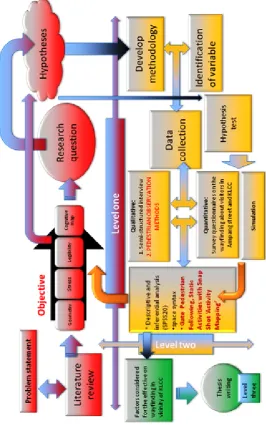
Chapter 5: It presents research methodology in this study. It also defines how to collect data which is divided into four major types including survey questionnaire, interview, observation, and axial map as a behavioural mapping in order to examine the research objectives. It is followed by the types of analysis used in this research including descriptive analysis, inferential analysis and finally normality and reliability analysis as a confirmatory factor analysis and justifies the methodology in relation to the literature and research analysis framework used in chapter 6.
Chapter 6: It encompasses the findings of the research together with discussion. The findings are the factors which influence geometry in effective elements of wayfinding such as legibility, cognitive map and stress. Then, the findings are discussed in different aspects including “value of geometry to legibility and cognitive map”, “impact of regular geometry on cognitive map and urban stress”, “analyzing and comparing hypothetical model and existing space by space syntax”, and “syntactical analysis on accessible and sociable with square as a regular geometry”.
228
REFERENCES
Aangeenbrug, R. T. (1991). A Critique of GIS. Geographical Information System:
Principles and Applications, 1, 101-107.
Afrooz, A. E. (2009). Assessing Wayfinding of Users in Unfamiliar Larg-scale
Urban Places. Master of Urban Design, Universiti Teknologi Malaysia,
Skudai. UTM database. (FAB30000010817)
Aguirre, K. G., and D'Esposito, M. (1999). Topographical Disorientation: a Synthesis and Taxonomy. Brain, 122, 1613–1628.
Ahmadi, V., Irfan, A., Farkisch, H., and Surat, M. (2012). Morphological STUDY of Urban Hierarchy in Boshrooeh City of IRAN. International Journal of
Architectural Research 6(3), 56-71.
Al-bvzjany, A. M. i. M. (1991). Iranian Geometry - Books Trade. Tehran: Soroush. Alexander, C. (1968). Notes on the Synthesis. Cambridge, MA: Harvard University
Press.
Alexander, C. (1987). A New Theory of Urban Design. New York: Oxford University Press.
Allen, A., Kennedy, P., Cryan, J., Dinan, T., and Clarke, G. (2013). Biological and Psychological Markers of Stress in Humans: Focus on the Trier Social Stress Test. Neuroscience and Biobehavioral Reviews, In press.
Allen, G. (1999a). Cognitive Abilities in the Service of Wayfinding: A Functional Approach. The Professional Geographer, 51(4), 555–561.
Allen, G. (1999b). Spatial Abilities, Cognitive map, and Wayfinding: Based for
Individual Differencees in Spatial Cognition and Behavior. Baltimore, MD:
The Johns Hopkins University press.
Allen, G. (2000). Principles and Practices for Communicating Route Knowledge.
Applied Cognitive Psychology, 14, 333–359.
Alstott, J. (2007). Security, Information, and Memory Determine Locomotor
147
Alvarez, P., Zola-Morgan, S., and Squire, L. R. (1995). Damage Limited to the Hippocampal Region Produces Long-lasting Memory Impairment in Monkeys. Journal of Neuroscience, 15(5 Pt 2), 3796–3807.
Amaratunga, D., Sarshar, M., and Baldry, D. (2002). Process Improvement in Facilities Management: the SPICE Approach. Business Process Management
Journal, 8(4), 318-337.
Appleton, R. B. (1922). Nte Elements of Greekphilosophyfrom Ntales to Aristotle. London: Methuen.
Ardalan, N., and Bakhtiar, L. (1999). Unity Sense (S. Hamid, Trans.). Isfahan: Iran: Publishing Soil.
Arthur, P., and Pasini, R. (1992). Wayfinding: People, Signs, and Architecture. New York: McGraw-Hill Book Company.
Asselena, M. V., Kesselsa, R. P. C., Kappelleb, L. J., Neggersa, S. F. W., Frijnsb, C. J. M., and Postmaa, A. (2005). Neural Correlates of Human Wayfinding in Stroke Patients. Brain research, 1067, 2 2 9 – 2 3 8.
Astur, R., Ortiz, M., and Sutherland, R. (1998). A Characterization of Performance by Men and Women in a Virtual Morris Water Task: A Large and Reliable Sex Difference. Behavioural Brain Research, 93(1-2), 185-190.
Atkinson, R., Atkinson, R., Smith, E., Bem, D., and Nolen-Hoeksema, S. (1996).
Hilgard's Introduction to Psychology. Fort Worth: Harcourt Brace College
publishers.
Atkinson, R., and et al. (1996). Hilgard's Introduction to Psychology: Fort Worth: Harcourt Brace College Publishers.
Avni, R., and Eilam, D. (2008). On the Border: Perimeter Patrolling as a Proposed Transitional Exploration Phase from Piloting to Orienting in a Diurnal Rodent, the Fat Sand Rat (Psammomy Obesus). Anim Cogn, 11, 311–318. Baker, G., H. (1992). Design Strategies in Architecture. New York: Van Nostrad
Reinhold pub, 8.
Barrash, J. (1994). Age-related Decline in Route Learning Ability. Dev
Neuropsychol, 10, 189–201.
Barton, J., and Pretty, J. (2010). What Is the Best Dose of Nature and Green Exercise for Improving Mental Health? Amulti-study Analysis. Environmental Science
148
Batty, M., and Longley, P. (1994). Fractal Cities: A Geometry of Form and
Function, 1st edn. New York: Academic Press.
Beatley, T. (2000). Green Urbanism. Washington, DC: Island Press.
Begega, A., Cienfuegos, S., Rubio, S., Santin, J. L., Miranda, R., and Arias, J. L. (2001). Effects of Ageing on Allocentric and Egocentric Spatial Strategies in the Wistar Rat. Behavioural Processes, 53(1-2), 75-85.
Belir, O., and Onder, D. E. (2013). Accessibility in Public Spaces: Spatial Legibility
for Visually Impaired People. Paper Presented at the Ninth International
Space Syntax Symposium, Seoul.
Bell, P. A., Greene, T. C., Fisher, J. D., and Baum, A. (2001). Environmental
Psychology (5th ed.). Orlando , FL: Harcpurt College Publishers.
Ben-Joseph, S. (1997). Streets and the Shaping of Towns and Cities.
Bentz, D., Michael, T., Wilhelm, F. H., Hartmann, F. R., Kunz, S., von R., and de Quervain, D. J. F. (2013). Influence of Stress on Fear Memory Processes in an Aversive Differential Conditioning Paradigm in Humans.
Psychoneuroendocrinology(0). doi:
http://dx.doi.org/10.1016/j.psyneuen.2012.12.018
Berg, M. (1998). The politics of Technology: on Bringing Social Theory into Technological Design. Science, Technology, and Human Values, 23(4), 456-490.
Blakey, R. (1850). History of the Philosophy of Mind. London: Longman, Brown, Green and Longmans.
Bohbot, V. D., Gupta, M., Banner, H., and Dahmani, L. (2011). Caudate Nucleus-Dependent Response Strategies in a Virtual Navigation Task are Associated with Lower Basal Cortisol and Impaired Episodic Memory. Neurobiology of
Learning and Memory, 96(2), 173-180. doi:
http://dx.doi.org/10.1016/j.nlm.2011.04.007
Bohbot, V. D., Iaria, G., and Petrides, M. (2004). Hippocampal Function and Spatial Memory: Evidence from Functional Neuroimaging in Healthy Participants and Performance of Patients with Medial Temporal Lobe Resections.
Neuropsychology, 18(3), 418–425.
Bottoni, G., Cappa, S., Geminiani, G., and Sterzi, R. (1990). Topographic Disorientation: a Case Report. Neuropsychologia, 28, 309–312.
149
Brandon, K. (2008). Behavior. 36(6), 839-867. Retrieved from http://www.kellybrandondesign.com
Brown, J. D. (1996). Testing in Language Programs. Upper Saddle River, NJ: Prentice Hall Regents. Modern and Interactive Approach to Learning
Engineering Mathematics, British Journal of Educational Technology, 32(2),
195-207.
Bruce, P., and Herman, J. (1983). Spatial Knowledge of Young and Elderly Adults: Scene Recognition from Familiar and Novel Perspectives. Exp Aging Res, 9, 169–173.
Burgess, N. (2006). Spatial Memory: How Egocentric and Allocentric Combine.
Trends Cogn. Sci, 10(12), 551–557.
Burgess, N., and Maguire, E. A. (2002). The Human Hippocampus and Spatial and Episodic Memory. Neuron, 35, 625–641.
Burkhart, T., Michon, J. L., and Nasr, S. H. (2009). Art of Islam, Language and
Meaning (Library of Perennial Philosophy Sacred Art in Tradition): World
Wisdom.
Buzsa´ ki, G. (2010). Neural Syntax: Cell Assemblies, Synapsembles, and Readers.
Neuron, 68, 362–385.
Caduff, D., and Timpf, S. (2008). On the Assessment of Landmark Salience for Human Navigation. Cognitive Processing, 9, 249–267.
Campos, M. B. A. (2000). Urban Public Spaces: A Study of the Relation between
Spatial Configuration and Use Patterns. Ph.D, UCL, London.
Cangoz, B. (2005). Gecmisten Gunumuze Bellegi Aciklamaya Yonelik Yaklasimlara Kisa Bir Bakis. Hacettepe Universitesi Edebiyat Fakultesi Dergisi, 22(1), 51-62.
Carbon, C., and Hesslinger, V. M. (2013 ). Attitudes and Cognitive Distances: On the Non-unitary and Flexible Nature of Cognitive maps. Advances in
Cognitive Psychology, 9(3), 121-129. doi: 10.2478/v10053-008-0140-y
Carpman, J. R., and Grant, M. A. (2002). Wayfinding: A Broad View. New York: John Wiley and Sons.
150
Chebat, J.-C., Gelinas-Chebat, C., and Therrien, K. (2005). Lost in a Mall, the Effects of Gender, Familiarity with the Shopping Mall and the Shopping Values on Shoppers’ Wayfinding Processes. Journal of Business Research, 58, 1590-1598.
Chen, C. H., Chang, W. C., and Chang, W. T. (2009). Gender Differences in Relation to Wayfinding Strategies, Navigational Support Design, and Wayfinding Task Difficulty. Journal of Environmental Psychology, 29(2), 220-226.
Cheng, K. (1986). A Purely Geometric Module in the Rat’s Spatial Representation.
Cognition, 23, 149–178.
Cheng, K. (2008). Whither Geometry? Troubles of the Geometric Module. Trends
Cogn Science, 12, 355–361.
Cheng, K., and Gallistel, C. R. (1984). Testing the Geometric Power of an Animal’s
Spatial Representation. Erlbaum: Hillsdale, NJ.
Cheng, K., and Gallistel, C. R. (2005). Shape Parameters Explain Data from Spatial Transformations: Comment on Pearce et al. (2004) and Tommasi and Polli (2004) Journal of Experimental Psychology: Animal Behavior Processes, 31(2), 254–259.
Chesterton. (1997). Pedestrian Market Research Services Ltd. Managing Urban
Spaces in Town Centres. London: The Stationery Office.
Chitsazian, A. (2007). Symbolism and Its Effect on the Carpet. Goljaam, 4(Society of Iranian carpets), 37-40.
Chitsazian, A. (2010). Recognizing the Campus in Symbolic Architecture and Carpet Platform of Iran. Goljaam, 12( Journal of Pavement Research Society), 99-122.
Clark, H. H. (1996). Using Language. Cambridge, UK: Cambridge University Press. Clearfield, M. W. (2004). The Role of Crawling and Walking Experience in Infant
Spatial Memory. Journal of Experimental Child Psychology, 89, 214–241. Collins, C. C., Collins, G. R., and Sitte, C. (2006). Camillo Sitte: The Birth of
Modern City Planning: With a Translation of the 1889 Austrian Edition of
His City Planning According to Artistic Principles. New York: Dover
151
Collins, K. M. T., Onwuegbuzie, A. J., and Jiao, Q. J. (2006). Prevalence of Mixed-Methods Sampling Designs in Social Science Research. Evaluation &
Research in Education, 19(2), 83-101.
Coluccia, E., and Louse, G. (2004). Gender Differences in Spatial Orientation: A Review. Journal of Environmental Psychology, 24(3), 329-340.
Conrad, C., Galea, L., Kuroda, Y., and McEwen, B. (1996). Chronic Stress Impairs Rat Spatial Memory on the Y maze, and This Effect is Blocked by Tianeptine Pretreatment. Behavioral Neuroscience, 110(6), 1321–1334.
Conroy-Dalton, R. (2003). The Secret Is to Follow Your Nose. Route Path Selection and Angularity. Environment and Behavioral 35(1), 107–131.
Conroy, R. (2001). Spatial Navigation in Immersive Virtual Environments. Faculty
of Built Environment. University of London, London, 249.
Conzen, M. R. G., and Conzen, M. P. (2004). Thinking About Urban Form: Papers
on Urban Morphology. Oxford; New York: Peter Lang.
Cooper, R., Schindler, S., and Hill. (2006). Marketing Research. New York: McGraw.
Cornell, E., Sorenson, A., and Mio, T. (2003). Human Sense of Direction and Wayfinding. Annals of the Association of American Geographers, 93(2), 399–425.
Cottrell, N. D., and Barton, B. K. (2012). The Impact of Artificial Vehicle Sounds for Pedestrians on Driver Stress. Ergonomics, 55(12), 1476-1486. doi: 10.1080/00140139.2012.724452
Crampton, J. (1992). A Cognitive Analysis of Wayfinding Expertise. Cartographica, 29(3/4), 46–65.
Creswell, J. W., Plano Clark, V. L., Gutmann, M., and Hanson, W. (2003). Advanced Mixed Methods Research Designs. In A. Tashakkori and C. Teddlie (Eds.),
Handbook of Mixed Methods in Social and Behavioral Research (pp. 209–
240). Thousand Oaks, CA: Sage.
Crewe, K., and Forsyth, A. (2011). Compactness and Connection in Environmental Design: Insights from Ecoburbs and Ecocities for Design with Nature.
Environment and Planning B: Planning and Design, 38(2), 267-288.
152
Critchlow, K. (1987). Order in Space: A Design Source Book. . USA: Thames and Hudson.
Cubukcu, E. (2003). Investigating Wayfinding Using Virtual Environment. Ph.D, The Ohio State University.
Cubukcu, E., and Nasar, J. (2005). Relation of Physical Form to Spatial Knowledge in Largescale Virtual Environments. Environment and Behaviour, 37(3), 397–317.
Cutini, V. (2003). Lines and Squares: Towards a Configurational Approach to the
Morphology of Open Spaces. Paper Presented at the 4th International Space
Syntax Symposium, London.
Dabbour, L. M. (2012). Geometric Proportions: The Underlying Structure of Design Process for Islamic Geometric Patterns. Frontiers of Architectural Research, 1(4), 380-391. doi: http://dx.doi.org/10.1016/j.foar.2012.08.005
Dalke, H., Little, J., Niemann, E., Camg¨oz, N., Steadman, G., and Hill, S. (2005). Colour and Lighting in Hospital Design. Optics and Laser Technology, 38, 343–365.
Dalton, N. (2003). Fractional Configurational Analysis and a Solution to the
Manhattan Problem. Paper Presented at the 3rd International Symposium on
Space Syntax, Georgia, Institute of Technology, Atlanta.
Dalton, R. C., and Bafna, S. (2003). The Syntactical Image of the City: A Reciprocal
Definition of Spatial Elements and Spatial Syntaxes. Paper Presented at the
4th International Space Syntax Symposium London.
Dalton, R. C., H'olscher, C., and Turner, A. (2012). Understanding Space: the Nascent Synthesis of Cognition and the Syntax of Spatial Morphologies.
Environment and Planning B: Planning and Design, 39(1), 7-11.
Darken R. P., and Sibert, J. L. (1996). Wayfinding Strategies and Behaviors in Large
Virtual Worlds. Paper Presented at the CHI '96 Proceedings of the SIGCHI
Conference on Human Factors in Computing Syste New York, NY, USA. Darcy, S. and T. J. Dickson (2009). A whole-of-life approach to tourism: The case
for accessible tourism experiences. Journal of Hospitality and Tourism
Management 16(01): 32-44.
de Vries, S. (2010). Nearby Nature and Humanhealth: Looking at the Mechanisms
153
Dehaene, S., Izard, V., Pica, P., and Spelke, E. S. (2006). Core Knowledge of Geometry in an Amazonian Indigene Group. Science, 311, 381–384.
Denis, M., Pazzaglia, F., Cornoldi, C., and Bertolo, L. (1999). Spatial Discourse and Navigation: An Analysis of Route Directions in the City of Venice. Applied
Cognitive Psychology, 13(2), 145–174.
Devlin, A. S. (2001). Mind and Maze: Spatial Cognition and Environmental
Behavior: Greenwood Press.
Dinan, T. (1996). Fran stress till depression: SERIP.
Downs, R. M., and Stea, D. (1973). Image and Environment: Cognitive Mapping and
Spatial Behavior. Chicago: Aldine Publishing Co.
Driscoll, I., and Sutherland, R. J. (2005). The Aging Hippocampus: Navigating between Rat and Human Experiments. Reviews in the Neurosciences, 16(2), 87-121.
Dupret, D., O’Neill, J., and Csicsvari, J. (2013). Dynamic Reconfiguration of Hippocampal Interneuron Circuits During Spatial Learning. Neuron, in press. doi: http://dx.doi.org/10.1016/j.neuron.2013.01.033
Dupret, D., O’Neill, J., Pleydell-Bouverie, B., and Csicsvari, J. (2010). The Reorganization and Reactivation of Hippocampal Maps Predict Spatial Memory Performance. Nat. Neurosci., 13, 995–1002.
Dussutour, A., Deneubourg, J., and Fourcassié, V. (2005). Amplifcation of Individual Preferences in a Social Context: The Case of Wall-following in ants. Proc R Soc B Biol, 272, 705–714.
Edwards, D., et al. (2008). Urban tourism research: developing an agenda. Annals of
Tourism Research 35(4): 1032-1052.
Edwards, D., and Griffin, T. (2013). Understanding Tourists’ Spatial Behaviour: GPS Tracking as an Aid to Sustainable Destination Management. Journal of
Sustainable Tourism Management, 1-16. doi:
10.1080/09669582.2013.776063
Eichenbaum, H., and Cohen, N. J. (2001). From Conditioning to Conscious
Recollection. New York: Oxford University Press.
Emo, B. (2013). Seeing the Axial Line: Evidence from Wayfinding Experiments.
154
Emo, B., Hölscher, C., Wiener, J. M., and Dalton, R. C. (2012). Wayfinding and
Spatial Configuration: Evidence from Street Corners. Paper Presented at the
Proceedings of the 8th Space Syntax Symposium, Pontifícia Universidad. Esfahani, R. (1953). Almfrdat fi Gharib al-quran. Tehran: nasr maktab Mortazavi. Etienne, A. (2003). How Does Path Integration Interact with Olfaction, Vision, and
the Representation of Space? Oxford, England: Oxford University Press.
Etienne, A., Berlie, J., Georgakopoulos, J., and Maurer, M. (1998). Role of Dead
Reckoning in Navigation. Oxford: Oxford University Press.
Eysenck, M. W. (1990). Blackwell Dictionary of Cognitive Psychology. Cambridge, MA: Basil Blackwell.
Faria, A. P. N., and Krafta, R. (2003). Representing Urban Cognitive Structure
Through Spatial Differentiation. Paper Presented at the 4th International
Space Syntax Symposium, London.
Farshidnick, F., et al. (2010). An Alter Product Semiotics: Masjed Architecture Is Reflected in the Carpet. Goljaam, 14( the Journal of Pavement Research Society), 9-27.
Feist, G., and Rosenberg, E. (2009). Psychology: Making Connections. New York: McGraw-Hill.
Fewings, R. (2001). Wayfinding and Airport Terminal Design. Journal of
Navigation, 54(2).
Foo, P., Harrison, M., Duchon, A., Harren, W. H., and Tarr, M. J. (2004). Humans Follow Landmarks over Path Integration. Journal of Vision, 4(8).
Foo, P., Warren, W. H., Duchon, A., and Tarr, M. J. (2005). Do Humans Integrate Routes into a Cognitive map? Map- Versus Landmark-based Navigation of Novel Shortcuts. Journal of Experimental Psychology: Learning, Memory,
and Cognition, 31, 195–215.
Francis, M. L. (1984). Mapping Downtown Activity. Journal of Architectural and
Planning Research, 1, 21-35.
French, J. S. (1983). Urban Space – A Brief History of the City Square. Iowa: Kendall Hunt Publishing.
Ga¨ rling, T., Bo¨ o¨ k, A., and Lindberg, E. (1986). Spatial Orientation and Wayfinding in the Designed Environment. Journal of Architectural Planning
Research, 3, 55–64.
155
Geddes, P., and Library. (2008). Civics: As Applied Sociology. Teddington: Echo. Gehl, J., and Gemzoe, L. (2001). New City Spaces. Copenhagen. Denmark: The
Danish Architectural Press.
Ghehi, H. B. (2010a). The Geometry of Imagination and Beauty Tehran: Shadrang. Ghehi, H. B. (2010b). Spiritual Principles of Islamic Art and Architecture. Tehran:
Soreh Mehr.
Giddings, B. (1996). Towards the Urban Restoration of Newcastle Upon Tyne.
URBAN DESIGN International, 1(3), 265–281.
Giddings, B., Charlton, J., and Horne, M. (2011). Public Squares in European City Centres. URBAN DESIGN International, 16(3), 202–212.
Giddings, B., Hopwood, B., Mellor, M., and O’Brien, G. (2005). Back to the City: A
Route for Urban Sustainability. Oxford: Architectural Press.
Giedion, S. (1962). Space, Time, Architecture. Cambridge: Harvard University Press. Giuliani, R. (2001). Universal Design New York. New York: Mayor Publication. Goel, V. (1995). Sketches of Thought. Cambridge, Mass: MIT Press.
Golany, G. (1995). Ethics and URBAN DESIGN: Culture, Form, and Environment. New York: John Wiley and Sons.
Goldschmidt, G., and Badke-Schaub, P. (2010). The Design-psychology. Sydney, Australia: DAB Documents.
Golledge, R. (1999). Human Cognitive Maps and Wayfinding. Baltimore: Johns Hopkins University Press.
Golledge, R., and Gärling, T. (2004). Cognitive Maps and Urban Travel, in
Handbook of Transport Geography and Spatial Systems. Amsterdam:
Elevesier.
Gospodini, A. (2001). Urban design, urban space morphology, urban tourism: an emerging new paradigm concerning their relationship. European Planning
Studies 9(7): 925-934.
Gould, P., and White, R. (1986). Mental Maps. Boston: Allen and Unwin.
Gould, T., Dao, D., and Kovacsics, C. (2009). The Open Field Test: Humana Press. Graham, P., Fauria, K., and Collett, T. (2003). The Influence of Beacon-Aiming on
the Routes of Wood Ants. J Exp Biol, 206, 535.
Grahn, P., Ivarsson, C. T., Stigsdotter, I. K., and Bengtsson, I. (2010). Innovative Approaches in Researching Landscape and Health, Open Space: People
156
Grahn, P., and Stigsdotter, U. A. (2003). Landscape Planning and Stress. Urban
Forestry and Urban Greening, 2, 1-18.
Gray, W. D., Sims, C. R., Fu, W.-T., and Schoelles, M. J. (2006). The Soft Constraints Hypothesis: A Rational Analysis Approach to Resource Allocation for Interactive Behavior. Psychological Review, 113(3), 461–482. Grön, G., Wunderlich, A. P., Spitzer, M., Tomczak, R., and Riepe, M. W. (2000).
Brain Activation During Human Navigation: Gender-Different Neural Networks as Substrate of Performance. Nature Neuroscience, 3(4), 404–408. Habel, C. (1988). Prozedurale Aspekte der Wegplanung und Wegbeschreibung
[Procedural aspects of route planning and route description]. Paper
Presented at the Sprache in Mensch und Computer, Opladen: Westdt.
Haciomeroglu, M., Laycock, R. G., and Day, A. M. (2007). Distributing Pedestrians
in a Virtual Environment. Paper presented at the International Conference on
Cyberworlds, Norwich, UK, School of Computing Sciences, University of East Anglia.
Hannes, E., Kusumastuti, D., Espinosa, M. L., Janssens, D., Vanhoof, K., and Wets, G. (2012). Mental Maps and Travel Behaviour: Meanings and Models.
Journal of Geographical Systems, 14, 143-165. doi:
10.1007/s10109-010-0144-2 V
Hano, K. (2011). Accessible Tourism: Concepts and Issues. Tourism Planning &
Development 8(4): 467-468.
Hanson, J. (1989). Order and Structure in Urban Design: The Plans for the Rebuilding of London after the Great Fire of 1666. Ekistics,
334/335(Jan/Feb, Mar/Apr), 22–42.
Hartig, T., Book, A., Garvill, J., Olsson, T., and Garling, T. (1996). Environmental Influences on Psychological Restoration. Scandinavian Journal of
psychology, 4(37), 378-393.
Hartley, T., Maguire, E. A., Spiers, H. J., and Burgess, N. (2003). The Well-worn Route and the Path Less Traveled: Distinct Neural Bases of Route Following and Wayfinding in Humans. Neuron, 37(5), 877–888.
157
Hashim, M. S., and Said, I. (2013). Effectiveness of Wayfinding Towards Spatial Space and Human Behavior in Theme Park. Procedia - Social and
Behavioral Sciences, 85, 282 – 295.
Head, D., and Isomc, M. (2010). Age Effects on Wayfinding and Route Learning Skills. Behavioural Brain Research, 209 49–58.
Hecht, L. (1988). Mysterium Microcosmicum: the Geometric Basis for the Periodicity of the Elements. 21st Century Science, 18.
Heft, H. (1996). The Ecological Approach to Navigation. A Gibsonian Perspective. Dordrect, Netherlands: Kluwer Academic.
Heinrichs, M., Baumgartner, T., Kirschbaum, C., and Ehlert, U. (2003). Social Support and Oxytocin Interact to Suppress Cortisol and Subjective Responses to Psychosocial Stress Biological Psychiatry, 54(12), 1389–1398.
Hejazi, M. (2005). Geometry in nature and Persian architecture. Building and
Environment, 40(10), 1413-1427. doi:
http://dx.doi.org/10.1016/j.buildenv.2004.11.007
Hellqvist, E. (1999). Svensk Etymologisk Ordbok, Forsta Bandet. Lund: Gleerups. Hermer, L., and Spelke, E. (1994). A Geometric Process for Spatial Reorientation in
Young Children. Nature, 370, 57–59.
Herzog, T., Black, A., Fountaine, K., and Knotts, D. (1997). Reflection and Attentional Recovery as Distinctive Benefits of Restorative Environments.
Environment Psychology(17), 165-170.
Hill, M. R. (1984). Walking, Crossing Streets, and Choosing Pedestrian Routes: A
Survey of Recent Insights from the Social/ Behavioral Science. USA:
University of Nebraska Studies.
Hillier, B. (1984). Mansion House Square Inquiry: Proof of Evidence. Bartelett School of Architectural and planning, University College London: Unit for Architectural Studies.
Hillier, B. (1989). The Architecture of the Urban Object. Ekistics 56(334/335), 5–21. Hillier, B. (1996). Space Is the Machine: A Configurational Theory of Architecture.
Cambridge, MA: Cambridge University Press.
Hillier, B. (2003). The Architectures of Seeing and Going: or, Are Cities Shaped by
Bodies or Minds? and Is There a Syntax of Spatial Cognition? Paper
158
Hillier, B. (2008). Space and Spatiality: What the Built Environment Needs from Social Theory. Building Research & Information, 36(3), 36216–36230. Hillier, B., Burdett, R., Peponis, J., and Penn, A. (1987). Creating Life: or, does
Architecture Determine Anything? Architecture and Behaviour, 3(3), 233-250.
Hillier, B., and Hanson, J. (1984). The Social Logic of Space, Reprint. Cambridge, UK: Cambridge University Press.
Hillier, B., and Hanson, J. (1998). Space Syntax as a Research Programme. Urban
Morphology, 2(2), 108–110.
Hillier, B., Hanson, J., Peponis, J., Hudson, J., and Burdett, R. (1983). Space Syntax: A Different Urban Perspective. Architectural Journal, 30(November), 47–63. Hillier, B., and Iida, S. (2005). Network and Psychological Effects in Urban
Movement;Spatial Information Theory, Lecture Notes in Computer Science.
Berlin/Heidelberg: Springer.
Hillier, B., and Penn, A. (1996). Cities as Movement Economies. URBAN DESIGN
International, 1(1), 49–60.
Hillier, B., Penn, A., Hanson, J., Grajewski, T., and Xu, J. (1992). Natural Movement: Configuration and Attraction in Urban Pedestrian Movement.
Environment and Planning B: Planning and Design, 19.
Hillier, B., Penn, A., Hanson, J., Grajewski, T., and Xu, J. (1993). Natural Movement: Or Configuration and Attraction in Urban Pedestrian Movement.
Environment and Planning B: Planning and Design, 20, 2029–2066.
Hillier, B., and Shu, S. (2000). Crime and Urban Layout: The Need for Evidence;
Key Issues in Crime Prevention and Community Safety. London: Institute of
Public Policy Research.
Hishamuddin, M., S.,. (2005). Panduan Mudah Analisis Data Menggunakan SPSS
Windows. Skudai, Johor: UTM.
Hockey, G. R., Nickel, P., Roberts, A. C., and Roberts, M. H. (2009). Sensitivity of Candidate Markers of Psychophysiological Strain to Cyclical Changes in Manual Control Load During Simulated Process Control. Applied
Ergonomics(40), 1011–1018.
159
Hölscher, C., Dalton, R., and Turner, A. (2007). Space Syntax and Spatial Cognition. SFB/TR 8 Monographs.
Hölscher, C., Meilinger, T., Vrachliotis, G., Brösamle, M., and Knauff, M. (2005). Finding theWay Inside: Linking Architectural Design Analysis and Cognitive Processes. 1-23.
Hölscher, C., Meilinger, T., Vrachliotis, G., Brösamle, M., and Knauff, M. (2006). Up the Down Staircase: Wayfinding Strategies and Multi-level Buildings.
Journal of Environmental Psychology, 26(4), 284–299.
Hölscher, C., Tenbrink, T., and Wiener, J. M. (2011). Would You Follow Your Own Route Description? Cognitive Strategies in Urban Route Planning. Cognition, 121(2), 228-247. doi: http://dx.doi.org/10.1016/j.cognition.2011.06.005 Hong, I. (2007). Communal Ontology for Navigation Support in Urban Region:
Getting Directions from Familiar Landmarks. Ph.D Thesis, The state
University of new York, New York, Buffalo.
Hupbach, A., and Nadel, L. (2005). Reorientation in a Rhombic Environment: No Evidence for an Encapsulated Geometric Module. Cognitive Development 20, 279–302.
Iaria, G., Petrides, M., Dagher, A., Pike, B., and Bohbot, V. D. (2003). Cognitive Strategies Dependent on the Hippocampus and Caudate Nucleus in Human Navigation: Variability and Change with Practice. Journal of Neuroscience, 23(13), 5945–5952.
Ingold, T. (2000). Perception of the Environment: Essays in Livelihood, Dwelling
and Skill (1st ed. ed.). New York, NY: Routledge.
Ishikawa, T., and Montello, D. R. (2006). Spatial Knowledge Acquisition from Direct Experience in the Environment: Individual Differences in the Development of Metric Knowledge and the Integration of Separately Learned Places. Cognitive Psychology, 52(2), 93–129. doi: http://dx.doi.org/ 10.1016/j.cogpsych.2005.08.003
Izard, V., Pica, P., Spelke, E. S., and Dehaene, S. (2011). Flexible Intuitions of Euclidean Geometry in an Amazonian Indigene Group. Proceedings of the
National Academy of Sciences, 108, 9782–9787.
160
Jacobs, W. J., Laurance, H. E., and Thomas, K. G. F. (1997). Place Learning in Virtual Space I: Acquisition, Overshadowing, and Transfer. Learning and
Motivation, 28(4), 521-541.
Jansen-Osmann, P. (2002). Using Desktop Virtual Environments to Investigate the Role of Landmarks. Computers in Human Behavior, 18(4), 427-436.
Jansen-Osmann, P., and Fuchs, P. (2006). Wayfinding Behavior and Spatial Knowledge of Adults and Children in a Virtual Environment: The Role of Landmarks. Experimental Psychology, 53, 171–181.
Jeanson, R., Blanco, S., Fournier, R., Deneubourg, J., Fourcassie, V., and Theraulaz, G. A. (2003). Model of Animal Movements in a Bounded Space. J Theor
Biol, 225, 443–451.
Jeffrey, C. (2007). Wayfinding Brands: Clear a Path Through the Clutter. London: Brand Strategy.
Jiang, B., and Claramunt, B. (2002). Integration of Space Syntax into gis: New Perspectives for Urban Morphology. Transactions in GIS, 6(3), 295–309. Johnson, J. (2009). Embracing Complexity in Design. London: Routledge.
kamal, F. J. (2008). Research on Visual Background Light in Painting. Garden
Journal, 8, 26-30.
Kaplan, R., and Kaplan, S. (1989). The Experience of Nature. Cambridge: Cambridge University press.
Kaplan, S. (1990). Parks for the Future: A Psychological Perspective. Alnarp: Stad
and Land(85), 4-22.
kaplan, S., and Talbot, J. (1983). Psychological Benefits of a Wilderness Experience.
Human Behavior and the Environment, 6, 163-203.
Karimi, K. (2012). A Configurational Approach to Analytical Urban Design: Space Syntax Methodology. Urban Design International, 17(4), 297-318. doi: 10.1057/udi.2012.19
Kaymaz, I. (2013). Urban Landscapes and Identity. doi: http://dx.doi.org/10.5772/55754