8071
THE USE OF GOOGLE MAPS AND UNIVERSAL
TRANSVERSE MERCATOR (UTM) COORDINATE IN LAND
MEASUREMENT OF REGION IN DIFFERENT ZONE
1ADI SETIAWAN , 2EKO SEDIYONO
1Department of Mathematics, Faculty of Science and Mathematics,
Universitas Kristen Satya Wacana, Indonesia
2Faculty of Information Technology, Universitas Kristen Satya Wacana, Indonesia
E-mail: 2[email protected] (corresponding)
ABSTRACT
The methods in determining land area measurement based on UTM coordinate are very few. In this paper, we present the use of Google Maps and Universal Transverse Mercator (UTM) to determine the measurement of land area in two or four different zones of UTM coordinate based on the proposed method. We proposed the rectangular method. The proposed method is then applied in determining of regional area of regencies in Central Kalimantan such as Kapuas Regency and Murung Raya Regency. If the method is applied to determine the measurement of land area in Kalimantan Tengah, the mean of absolute percentage error (MAPE) is 14.45 %.
Keywords: Universal Transverse Mercator, Google Maps, Land Measurement, Zone, Coordinate System
1. INTRODUCTION
Measuring the area of land and the establishment of the land boundary is critical. Especially an area of an extensive estate. It needs time and money.
Universal Transverse Mercator (UTM) coordinate systems are rarely used compared to latitude-longitude coordinate systems [1]. However, in order to determine the distance between two points using Euclid distance method, it will be more precise to UTM coordinate system (for more information of UTM coordinate system see [2]). In the paper [3], it has been explained how the rectangular method is proposed to determine the area of Gili Air island, Salatiga city, Central Java province, Daerah Istimewa Yogyakarta province and Daerah Khusus Ibukota Jakarta province. However, these areas are within one UTM zone. In this paper, it will be proposed how the rectangular method can also be used to determine the area located in different UTM zones. The proposed method is then used in determining the area of districts in Central Kalimantan. The selection of this province based on the location of the regencies
within the regions located in two zones and some in four zones.
2. LITERATURE REVIEW
ISSN: 1992-8645 www.jatit.org E-ISSN: 1817-3195
8072 method. In this literature review, it is presented the methods to convert the geographical coordinate based on [4] and the recent paper [5].
Suppose a point is present on the surface of the earth with coordinates (φ, λ) where φ representing latitude coordinate and λ representing longitudinal coordinate. To facilitate the calculation of the distance between two points on the surface of the earth then the coordinate system needs to be transformed into a UTM coordinate system by using the following calculation (in meter) [4] :
a = 6378137 ( semi-major axis ), b = 6356752.314245 (semi-major axis), f = (a-b)/a,
, 2 2 2 2 a b a
e
, 2 f f b a b a n , ) sin 1 ( ) 1 ( 2 2 2 e e a , ) sin 1
( 2 2 1/2
e a
SABsin2Csin4Dsin6Esin8,
,64 81 4
5
1 2 3 4 5
a n n n n n
A
, 64 55 8 7 23 2 3 4 5
a n n n n n
B
,4 3 16
15 2 3 4 5
a n n n n
C
, 16 11 48
35 3 4 5
a n n n
D
,512
315 4 5
an n
E
0 = longitude of the meridian,
0
k0 = central scale factor = 0.9996, FN = False Northing,
FE = False Easting (= 500000), E = grid easting,
N = grid northing, ,
1 Sk0
T
, 2
cos sin
2 v k0
T
5 tan 9 cos 4 cos
, 24cos sin
3 v 3k0 2 e'2 2 e'4 4
T
T4vsincos5k0
720 (6158tan
2 tan4 270e'2cos2 330 tan2 e2cos2 445e4cos4 324e6cos6
680 tan2e'4cos488e'8cos8600 tan2e5cos6
192 tan2e8cos8),
), tan tan 543 tan 3111 1385 ( 40320 cos sin
5 0 2 4 6
7
v k
T
, cos
6 v k0
T
1 tan cos , 6
cos
7 v 3k0 2 e'2 2
T
T8vcos5k0
120 (518 tan
2tan414e'2cos2
58 tan2e2cos213e4cos44e6cos6 61 479tan 179tan tan , 5040
cos
9v 7k0 2 4 6
T
such that the Easting coordinate is
), 5 ) ( 4 ) ( 3 ) ( 2 ) ( 1
(T 2T 4T 6T 8T
FN
N
and the Northing coordinate is
). 9 ) ( 8 ) ( 7 ) ( 6
( T 3T 5T 7T
FE
E
Suppose that the coordinates A1 and B1 are (-0.289287, 113.41617) and (-1.653229, 113.504159), respectively, where the first axis is latitude coordinate and the second axis is longitude coordinate. Coordinate A1 can be converted to UTM coordinates by using
f = 0.00335281, e2 = 0.00669438, e’2= 0.0067397, n = 0.00167922,
= 6335440.94905524,
= 6378137.54423084, A = 6367449.14582333, B = 16038.50866311, C = 16.83261326, D = 0.02198440, E = 0.00003115, S = 768997.22156522, T1 = -31974.90817774, T2 = -16094.92794697, T3= -6787.608130672, T4 = -2809.243975975, T5 = -1105.580064766, T6 = 6375505.02454235, T7 = 1069690.91279259, T8= 270651.53490600, T9 = 77148.40380713,
such that the Easting = 768936.077649187
768936.08, the Northing = 9967996.448422255
9967996.45 and located in zone 49 M. Similarly, the coordinates of Easting and Northing are 778624.15 and 9817092.27, respectively and located in zone 49 M. Since both points are in one UTM zone and by using the Euclid distance, it can be obtained that the distance between point A1 and point B2 is
2 2 (9967996.45 9817092.27)
) 15 . 778624 08 . 768936 ( d 2 2 (150904.17)
) 07 . 9688 ( d
8073 Conversely, if the UTM coordinates (E, N) and the zone of the location are known then to obtain the geographical coordinates can be used the following procedures. Suppose
0 0 M , 0 0 k N M
M ,
2 1 2 2 1 2 1 1 1 1 1 e e e , 256 5 64 3 4 1 6 42 e e
e M ,
1 13
' 32 27 2 3 2
sin e e
3
1 4 1 2 96 151 6 sin 32 55 16 21 4
sin e1 e e
4 1 512 1097 6
sin e
FE E E
, 2 0 2 ' tan 10 vk T , ' cos 4 ' cos ' tan 3 5 ( 24 ' tan
11 2 '2 2 '4 4
4 0
3
e e k v
T
) ' cos ' tan
9 2 e'2 2
, ' tan 45 ' cos 46 ' tan 90 61 ( 720 ' tan
12 2 '2 2 4
5 0
5
e k v T ' cos 100 ' cos 3 ' cos ' tan
252 2 e'2 2 e'4 4 e'6 6
' cos ' tan 90 ' cos ' tan
66 2 e'4 4 4 e'2 2
' cos ' tan 225 ' cos
88e'8 8 4 e'4 4
) ' cos ' tan 192 ' cos ' tan
84 2 e'6 6 2 e'8 8
, ' tan 4095 ' tan 3633 1385 ( 40320 ' tan
13 2 4
8 0
7
k v T ) ' tan 1575 6
, 0 ' cos 1 14 k v T , ) ' cos ' tan 2 1 ( ' cos 6 1
15 2 '2 2
3 0
3 k e
v
T ,
' tan 28 ' cos 6 5 ( ' cos 120 1
16 '2 2 2
5 0
5
e k v T ' cos 4 ' tan 24 ' cos ' 8 ' cos
3e'4 4 an2e'2 2 4 e'6 6
) ' cos ' tan 24 ' cos ' tan
4 2 e'4 4 2 e'6 6
, ' tan 1320 ' tan 662 61 ( ' cos 5040 1
17 2 4
7 0
7
k v T
720 tan 6'),
then the latitude and longitude can be found by formulas , 13 ) ( 12 ) ( 11 ) ( 10 ) (
'E 2T E 4T E 6T E 8T
. 17 ) ( 16 ) ( 15 ) (
14 3 5 7
0ET E T E T E T
The coordinate UTM (E, N) = ( 768936.08, 9967996.45) in zone 49 M will be converted into geographical coordinate with the following steps. Because the location in zone 49 M, i.e. in the Southern Hemisphere then it is obtained
M = -32016.3565426178, e2 = 0.00669438,
e’2= 0.0067397, = -0.0050281291, e1 = 0.0016792204, T11 = -6.423472123 10-31, T12 = -6.450735067 10-45, T13 = -6.4019633487 10-59, T14 = 1.5685032305 10-7, T15 = 6.4748986901 10-22, T16 = 3.9878759867 10-36, T17 = 2.8273808024 10-50,
so that the result of latitude coordinate is
= -0.289287 and the longitude coordinate
= 113.416170. Thus the result is the same as the previous geographical coordinate.
Based on the recent paper, this following procedure can be used to convert the geographical coordinate into the UTM coordinate more briefly that the previous procedure. Let the geographical coordinate ( , ) where representing latitude coordinate and representing longitudinal coordinate [5] :
a = 6378137 ( semi-major axis ), f = 1/298.257223563,
k0 = 0.9996 , 2 f f n , .... 64 4 1 1 4 2
n n
n a A , 16 5 3 2 2 3 2 1 n n n
, 5 3 4813 2 3
2 n n
, 240 61 3 3 n
, sin 1 2 tanh 1 2 sin tanhsinh 1 1
ISSN: 1992-8645 www.jatit.org E-ISSN: 1817-3195 8074
,
)
cos(
tan
0 1
t
, 1 ) sin( tanh 2 0 1 t
such that the Easting coordinate is
, ) 2 sinh( ) 2 cos( 3 1 0 0
jj j j A
k E E
x
and the Northing coordinate is
. ) 2 cosh( ) 2 sin( 3 1 0 0
jj j j
A k N N
y
The coordinate A1 is (-0.289287, 113.41617) can be converted by using the procedure given in paper [5]. In this case, a = 6378137, f = 1/298.2572235605 and it is obtained
n = 0.0016792204, A = 6367449.1458234154,
1 = 0.0008377318,
2 = 7.6084969587 10-7,
3 = 1.2034877876 10-9, t = -0.0050152533,
= -0.0050196738,
= 0.0421820949,
(in meter ) such that the obtained Easting coordinate is E = 768936.0776497596 768936.08 and the Northing coordinate is N = 9967996.4484222736 9967996.45. The location is in zone 49 M. The procedure given in paper [5] is more briefly and the result can be considered same as the first procedure.
Note that all points on the earth's surface are mapped into the plane by dividing it into 60 zones with each zone having a width of 6 degrees longitude. Longitude 0o to longitude 180o in Eastern part of the earth have zone numbers from 31 until 60. The rest have zone numbers from 1 until 30. Furthermore, zone C to zone M zone lies in the southern hemisphere, each zone has a width of 8o except the zone C which has a width 12o. Zone N up to zone X are located at Northern hemisphere and each zone has width 8o except zone X which have width 12o. More information can be found in [8] and [2].
If the UTM coordinates (E, N) and the zone of the location are known then to obtain the geographical coordinates can be used formulas [5] :
3 1 , ) 2 sin( jj j
, 183 6 0 o o
zone , cos sinh tan 1 0 where , 2 3 2
2 2 3
1 n n n
,
5 8 3
7 2 3
2 n n
, 15 56 3
3 n
, 0 0 A k N N , 0 0 A k E E , 96 37 3 2 2 3 2 1 n n
n
, 15 48 3 2 2 n n , 480 17 3 3 n
3 1 ), 2 cosh( ) 2 sin( jj j j
3 1 ), 2 sinh( ) 2 cos( jj j j
. cosh sin sin 1
To check that the UTM coordinates of Easting 768936.08 and Northing 9967996.45 with zone 49 M will have the previous coordinates like all then the following steps are used. Since the location is in zone 49 M i.e. in the Southern Hemisphere then it is obtained
1 = 0.0033565514,
2 = 0.0000065719,
3 = 0.0000000177,
= -0.0050281291,
= 0.0422529794,
1 = 8.3773216408 10-4,
2 = 5.9061108637 10-8,
3 = 1.6769911794 10-10,
= -0.0050196735,
= 0.0421820952,
= -0.0050152110,
8075
Figure 1: The boundary points of Gunung Mas Regency.
[image:5.612.352.484.341.655.2]Table 1 presents the coordinates of the latitude and coordinates of longitudes of the boundaries of Gunung Mas district of Central Kalimantan province as described in Figure 1, whereas Table 2 presents the result of converting the latitude-longitude coordinate system into a UTM coordinate system. Using the rectangular method, the length of Gunung Mas Regency can be viewed as the distance between point A1 and point B1 which has coordinates (-1.653229, 113.416719) i.e. l = 150.8921 km (as a comparison, the Vincenty distance between two points is 150.8174 km).
Table 1: Latitude and Longitude on the Boundaries of Gunung Mas Regency.
No. Latitude Longitude 1 -0.382669 113.666658 2 -0.506262 113.751802 3 -0.629852 113.691378 4 -0.734214 113.652825 5 -0.844067 113.710604 6 -0.953917 113.814974 7 -1.028064 113.968782 8 -1.168114 113.985262 9 -1.275206 113.982515 10 -1.412497 113.999999 11 -1.500359 113.985262 12 -1.601065 113.883187 13 -1.559882 113.432748 14 -1.408871 113.284432 15 -1.274325 113.196542 16 -1.164487 113.213021 17 -1.062883 113.213021 18 -0.951254 113.117258 19 -0.860310 113.024218 20 -0.796007 113.040438
21 -0.716363 113.104982 22 -0.635345 113.154421 23 -0.530980 113.210726 24 -0.408761 113.267031
The width of Gunung Mas Regency can be obtained from the average distance of the points (1,24), (2, 23), (3, 22), (4,21), (5,20), (6,19), (7,18), (8,17), (9, 16), (10,15), (11, 14) and (12, 13) i.e. w = 72.8852 km. All points are in 1 UTM zone so that the distance calculation can directly use Euclid distance. Furthermore, the area of Gunung Mas Regency can be found by
A = (l)w = (150.8921)(72.8852)
i.e. 10997.80 km2. This result is 1.78% larger than the reference area.
Table 2: The Boundaries of Gunung Mas Regency in UTM coordinate based on Table 1.
No. Easting Northing
1 796833.6 9957657
2 866313.4 9943978
3 799576.9 9930305
4 795286.3 9918760
5 801703.1 9906600
6 813319.9 9894435
7 830447.1 9886214
8 832267.6 9870712
9 831948.4 9858859
10 833877.5 9843661
11 832222.9 9833938
12 820838.3 9822808
13 752324.5 9957670
14 746050.4 9944001
15 739775.6 9930333
16 734265.7 9918792
17 727073.5 9906646
18 725260.9 9894497
19 735614.1 9886290
20 746264.6 9870791
21 744114.4 9858947
22 744406.6 9843761
23 754181.2 9834032
24 770680.7 9822873
3. RESEARCH METHODS
[image:5.612.129.259.469.730.2]ISSN: 1992-8645 www.jatit.org E-ISSN: 1817-3195
8076 of regencies in Kalimantan Tengah. The methods can be applied to all regencies except Kapuas Regency and Murung Raya Regency. The distance between two UTM coordinate points depends on position of points within one zone or within a different zone. In the results and discussion, it is proposed a method of determining the distance between two points if the two points of UTM coordinates are in two or four different zones. Furthermore, it is also proposed to determine the distance between two points if one is in the Northern Hemisphere and the other is in the Southern Hemisphere. By using the rectangular method, the results are then used in determining the area of Kapuas Regency located in 2 UTM zones and Murung Raya Regency located in 4 different UTM zones.
4. RESULTS AND DISCUSSION
In the results and discussion, it is proposed that the measurement of the distance between two points in the UTM coordinates whether they are in the southern hemisphere or in the northern hemisphere yet they are in different zones. For example point A2 has latitude-longitude coordinates (-0.363641, 113.969798) and point B2 has latitude-longitude coordinates (-3.436162, 114.343967). In the UTM coordinate, they are (Easting, Northing, zone) = (830606.61, 9959752.32, 49 M) and (244872.15, 9619786.07, 50 M), respectively. To determine the distance between point A2 and point B2 can be done by calculating the distance between point A2 and zone border i.e. longitude line 114o E that can be approximated by the distance between A2 and point D2 (-0.363641, 113.999999) (see Figure. 2). Furthermore, the distance between point C2 (-0.363641, 114.343967) that has the same latitude as point A2 and the same longitude as point B2, with the boundary of the border zone 114o E can be approximated by the distance between C2 and point E2 (-0.363641, 114.000001). In UTM coordinates, points D2, C2 and E2 are respectively (Easting, Northing, zone) =
[image:6.612.331.497.89.256.2](833971.75, 9959751.21, 49 M ), (204349.33, 995963.22, 50 M ), (166028.25, 9959751.21, 49 M ).
Figure 2: Method of Calculating Distance Between 2 Points located in different zones and located in the same hemisphere.
Since point A2 and D2 are located in one zone it can easily be obtained the distance between point A2 and D2 by using a distance of Euclid i.e. 3.3651 km. Furthermore, the distance between point E2 and point C2 is 38.3211 km and the distance between points B2 and C2 is 339.9776 km. Finally, by using the Pythagoras theorem it can be obtained the distance between point A2 and point B2 is 342.5237 km ( as a comparison of Vincenty distance i.e. 342.2867 km). The difference between the two methods is only 0.2370 km or 237.0 meters.
[image:6.612.339.496.463.690.2]8077 The proposed method can be applied to determine the area of Kapuas regency, Central Kalimantan. Table 3 presents the coordinates of Kapuas regency boundaries as shown in Figure 3. The length of the Kapuas district area can be considered as the distance between point 1 (or point A2 in the above example) and point 16 (or point B2 in the above example) and can be approximated by the distance between point 1 and point 16′ (-0.363641, 114.343967) i.e. l = 340.0695 km.
The area width of Kapuas Regency can be obtained from the average distance of the points (2,30), (3, 29), (4, 28), (5,27), (6,26), (7,25), (8,24), (9,23), (10, 22), (11,21), (12, 20), (13,19 ), (14,18) and (15, 17) i.e. w = 52.3378 km. Furthermore, the area of Kapuas Regency can be found by
A = (l)w = (340.0695)(52.3378),
i.e. 17798.4835 km2. This result is 18.66 % more than the reference area.
Another case appeared when one point is in the Northern Hemisphere while the other is in the Southern Hemisphere. It will be determined the distance between point A3 (0.798250, 114.907438) and point B3 (-0.857881, 114.246885). In the UTM coordinate system, they are respectively obtained (Easting, Northing, zone) =
[image:7.612.126.260.466.734.2](267120.58, 88289.93, 50 N ), (193562.65, 9905068.01, 50 M ).
Table 3. Latitude and Longitude of the Boundaries of Kapuas Regency.
No. Latitude Longitude 1 -0.363641 113.969798 2 -0.525685 114.054949 3 -0.786593 114.151073 4 -0.978831 114.461436 5 -1.182041 114.711375 6 -1.431915 114.664683 7 -1.673525 114.593272 8 -1.822067 114.623633 9 -2.039462 114.705203 10 -2.194726 114.685781 11 -2.516846 114.545948 12 -2.718616 114.604212 13 -2.93199 114.534295 14 -3.319837 114.441073 15 -3.319837 114.359504 16 -3.43616 114.343967 17 -3.35861 114.126449 18 -3.14145 114.235208 19 -2.92423 114.223555 20 -2.73414 114.305125
21 -2.5052 114.309009 22 -2.26047 114.215763 23 -2.03815 114.130619 24 -1.81817 113.981306 25 -1.51344 113.962830 26 -1.35182 113.985926 27 -1.19018 113.981306 28 -0.95465 113.888923 29 -0.75835 113.664892 30 -0.54972 113.744335
It means that both points are in different zones since point A3 is in the Northern hemisphere while point B3 is in the southern hemisphere, however both points have longitude between 114o E and 120o E. To determine the distance between A3 and B3, it can be used the auxiliary point C3 (-0.857881, 114.907438) i.e. the point that has the same latitude as the latitude of the point B3 while the longitude equals the point A3, point E3 (0.000001, 114.907438) and point D3 (-0.000001, 114.907438 ) (see Figure. 4). In UTM coordinates, points D3, C3 and E3 are (Easting, Northing, zone) =
(267124.06, 9905114.61, 50 M), (267098.11, 9999999.89, 50 M), (267098.11, 0.11, 50 N).
In other words, point A3 and E3 are located in one zone therefore the distance between those points can be calculated by using Euclid distance, i.e. 88.2898 km. Similarly the points C3 and D3 are in 1 zone with a distance of 94.8853 km and point C3 and B3 are in 1 zone with a distance of 73.5614 km. Furthermore, the distance between A3 and B3 can be obtained with the Pythagoras theorem i.e. 197.3940 km (compare to the Vincenty distance i.e. 197.3363 km).
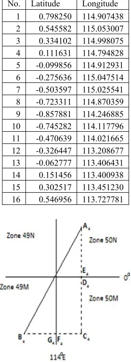
In addition, the distance between A4 points (0.798250, 114.907438) and B4 (-0.326447, 113.208677) will be determined. In the UTM coordinate system, respectively it is obtained (Easting, Northing, zone) =
(267120.58, 88289.93, 50 N), (745827.78, 9963890.79, 49 M).
ISSN: 1992-8645 www.jatit.org E-ISSN: 1817-3195
8078 114.907438), point E4 (0.000001, 114.907438), point F4 (-0.326447, 114.000001) and point G4 (-0.326447, 113.999999) (see Fig. 5). In UTM coordinates, the points D4, C4, E4, F4 and G4 respectively are (Easting, Northing, zone) =
(267098.11, 9999999.89, 50 M), (267101.87, 9963893.55, 50 M), (267098.11, 0.11, 50 N), (166026.95, 9963867.94, 50 M), (833973.05, 9963867.94, 49 M).
In other words, point A4 and E4 are located in one zone with the Euclid distance is 88.2898 km. Similarly point C4 and D4 are in 1 zone with distance 36.1063 km, point C4 and F4 are in 1 zone with distance 101,0749 km and point G4 and B4 are in 1 zone i.e. zone 49 M with distance 88.1453 km. By using Pythagoras theorem, the distance between A4 and B4 can be determined as 226.4479 km (in comparison, Vincenty distance is 226.3296 km).
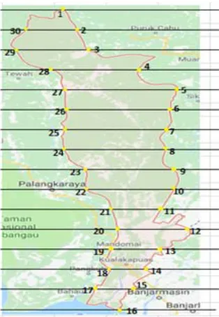
The length of Murung Raya district can be considered as the distance between point A4 and point C4 that is 183.1751 km (see Figure. 6). The width of Murung Raya district can be approximated by using the average distance of the points (2.16), (3, 15), (4, 14), (5.13), (6.12), (7.11) and (8,10) that is l = 149.1407 km. Thus the area of Murung Raya Regency region is
A = (l)w = (183.1751)(149.1407)
[image:8.612.350.485.138.509.2]i.e. 27318.8637 km2. The result is 15.27% greater than the reference area.
Figure 4. Method of Calculating Distance Between 2 Points, one in the Northern Hemisphere and one in the Southern Hemisphere.
Table 4. Latitude and Longitude of the Boundaries of Murung Raya Regency.
[image:8.612.127.260.463.648.2]No. Latitude Longitude 1 0.798250 114.907438 2 0.545582 115.053007 3 0.334102 114.998075 4 0.111631 114.794828 5 -0.099856 114.912931 6 -0.275636 115.047514 7 -0.503597 115.025541 8 -0.723311 114.870359 9 -0.857881 114.246885 10 -0.745282 114.117796 11 -0.470639 114.021665 12 -0.326447 113.208677 13 -0.062777 113.406431 14 0.151456 113.400938 15 0.302517 113.451230 16 0.546956 113.727781
[image:8.612.354.481.584.720.2]8079
[image:9.612.90.299.147.355.2]Figure 6. The boundary of Murung Raya Regency.
Table 5. Information of Used Data.
No. Regency The number of border points Reference Area
1
Kotawaringin
Barat 38 10759
2
Kotawaringin
Timur 40 16796
3 Kapuas 58 14999
4 Barito Selatan 50 8830
5 Barito Utara 52 8300
6 Sukamara 38 3827
7 Lamandau 38 6414
8 Seruyan 54 16404
9 Katingan 54 17500
10 Pulang Pisau 38 8997
11 Gunung Mas 52 10805
12 Barito Timur 52 3834
[image:9.612.97.293.383.588.2]13 Murung Raya 32 23700
Table 6. Result of Calculated Area.
No. Regency calculation Result of %
1
Kotawaringin
Barat 8916 -17.13
2 Kotawaringin Timur 16087 -4.22
3 Kapuas 18372 22.49
4 Barito Selatan 7422 -15.95
5 Barito Utara 10139 22.16
6 Sukamara 4380 14.45
7 Lamandau 7280 13.5
8 Seruyan 17629 7.47
9 Katingan 18509 5.77
10 Pulang Pisau 10585 17.65
11 Gunung Mas 10569 -2.18
12 Barito Timur 3098 -19.2
13 Murung Raya 24480 3.29
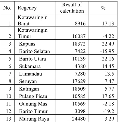
Based on the described method, the area of regency region in Central Kalimantan province can be determined by using the rectangular method. The results are presented in Table 6 and compared to the reference area (Table 5). The calculation of the area shows that there are some regencies that is smaller than the reference i.e. Kotawaringin Barat, Kotawaringin Timur, Barito Selatan, Gunung Mas and Barito Timur, meanwhile other regencies show that their area are greater than the reference. The
smallest absolute percentage error is found in Gunung Mas Regency while the largest absolute percentage error is found in Kapuas Regency. Based on these results, it can also be obtained that the mean of absolute percentage error (MAPE) is 14.45 %.
The difference in results obtained by using the rectangular method and the reference area is probably caused by the method used. Another possibility is also caused by the boundaries of territory provided by Google Maps that are not exactly equal to the administrative boundaries of regencies or cities in Kalimantan Tengah province (see in paper [9]). Other methods that can be used in land area measurement are Spherical Quadrilateral Approach Method (see in paper [7]) and polygon method (see in papers [8], [11], [12] and [13]).
5. CONCLUSION
In this paper we have presented how to use Google Maps and the UTM coordinates in land area measurement in different zone based on the rectangular method. The proposed method is then applied in determining of regional area of regencies in Central Kalimantan such as Kapuas Regency and Murung Raya Regency. The mean of absolute percentage error (MAPE) is 14.45 %. This research can be extended to determine regional area measurement by using other methods and the results are compared to the result of this method.
ACKNOWLEDGMENT
The authors would like to thank to Directorate General of Higher Education, Indonesia for research funding with scheme of Hibah Kompetensi fiscal year 2018.
REFERENCES:
[1] Kelly, K. M., Coordinate Transformations : Universal Transverse Mercator/ Geographic, The Association of Ontario Land Surveyors, 1989.
[2] Langley, R. B. The UTM Grid System, GPS World, Feb. 1998, pp. 46-50.
[3] Setiawan, A. & Sediyono, E., “A new Determination of regional Area by Utilizing Rectangular Approach Method and Google Maps”, ICITISEE, IEEE Xplore, 2017, page 417-420.
ISSN: 1992-8645 www.jatit.org E-ISSN: 1817-3195
8080 Mercator (UTM) and Universal Polar Stereographic (UPS)” Defense Mapping Agency, Fairfax, VA, 1989.
[5] Kawase, K. “Concise Derivation of Extensive Coordinate Conversion Formulae in the Gauss-Krüger Projection”, Bulletin of the Geospatial Information Authority of Japan, 60, pp 1–6, 2012.
[6] Vincenty, T., “Direct and inverse solutions of geodesics on the ellipsoid with application of nested equations”, Survey Review, 23 (176), 1975, page 88-93.
[7] Setiawan, A., Sediyono, E., “Using Google Maps and Spherical Quadrilateral Approach Method for Land Area Measurement”, ICI3INA IEEE Xplore, 2017.
[8] Snyder, H. P. , “ Map Projections – A Working Manual. U. S. Geological Survey Professional Paper 1395”, United States Government Printing Office, Washington, D. C, 1987. [9] Kumar, S. V. , “Are administrative boundaries
in Google maps correct”, Coordinates , December 2017.
[10] Karney, C. F. F., “Algorithms for geodesics”, J. Geodesy 87 (1),2013, page 43-45.
[11] Pedzich P., M. Kuzma, “Application of methods for area calculation of geodesic polygons on Polish administrative units”, Geodesy and Cartography, 2012,vol. 61, no. 2, page. 105-115.
[12] Sjoberg, L. E., “Determination of Area on the plane sphere and ellipsoid”, Survey Review, 2006,vol. 38, no. 301, page. S83-S93.