HOW DO YOU DESCRIBE A PLACING USING ITS PHYSICAL CHARACTERISTICS?
SSWG1A: Describe the concept of place by explaining how physical characteristics such as landforms, bodies of water, climate, soils, natural vegetation, and animal life are used to describe a place.
CATEGORY Information
Which landforms are used to describe places and regions
Plains
- Types of Plains 1)Savanna- Africa
2) Prairie- North America 3) Steppe- Europe/Asia 4) Pampas- South America Plateau
Mountains & Hills Valleys
Islands
Peninsula- land surrounded on 3 sides by water How are bodies of water
used to describe places and regions?
Oceans Gulfs and Bays Rivers
Lakes Seas
Ground Water
- Aquifer- underground layer of rock that stores water - Freshwater which lies beneath the earth’s surface - from rain, melted snow, lake and river water - Water that filtered through the soil into the ground What is the relationship
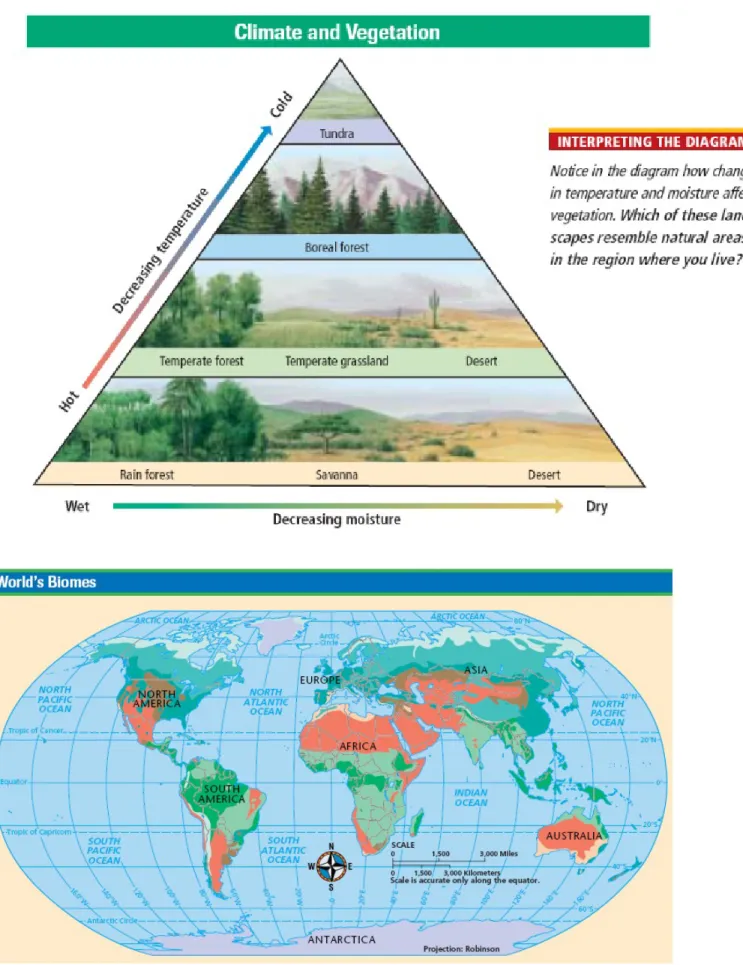
between climate and vegetation?
See Diagram A
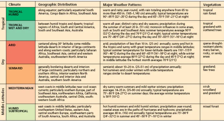
See Table B – Characteristics, Geographic Distribution of Climate & Vegetation
Tropical Ecosystems Tropical Humid
• Weather Patterns
Warm and rainy year round Annual precipitation 60-450 inches Day 900 – 950 F, Night 650 – 700 F
• Vegetation type
tropical rain forest • Geographic Distribution
Along equator, South America, Congo Basin, Africa, Southeast Asia Tropical Wet and Dry
• Weather Patterns Warm all year
Rainy and dry seasons Summer 700 – 900 F
Winter 650 – 800 F
• Vegetation Type
tropical grassland with scattered trees • Geographic Distribution
Between humid tropics and deserts, regions of Africa, South and Central America, South and Southeast Asia, Australia
Dry Ecosystems Semi-Arid
• Weather Patterns
Hot summers, cool winters Wide temperature variation • Geographic Distribution
Bordering deserts, interiors of continents, northern and southern Africa, central and interior Asia, Australia, and South America • Vegetation Type
Grassland; few trees Arid
• Weather Patterns
Annual precipitation less than 10 inches Sunny and hot in tropics
Sunny with great temperature ranges in middle latitudes 600 – 1150 F
• Geographic Distribution
Along 300, interior of large continents, along western coasts, Saharan Africa, SW Asia, central and western Australia, SW USA • Vegetation Type
Sparse drought resistant plants; barren, rocky, or sandy areas Mid-Latitude
Ecosystems
Mediterranean
• Weather Patterns
Dry sunny warm summers Mild wet winters
Annual precipitation 14-35 inches 500 – 800 F
• Geographic Distribution
West coast in middle latitudes, near cool ocean currents, southern Europe, part of SW Asia, NW Africa, California, SW Australia, central Chile, southern South Africa
• Vegetation Type
• Scrub woodland and grassland Humid Sub-Tropical
• Weather Pattern
Hot humid summers Mild humid winters
Year round precipitation, 40 inches
Coastal areas in paths of hurricanes and typhoons 450 – 900 F
• Geographic Distribution
East coasts in middle latitudes, SE USA, eastern Asia, central
southern Europe, southeastern parts of South America, South Africa and Australia
• Vegetation Type Mixed forest Marine West Coast
• Weather Patterns
Cloudy mild summers Cool rainy winters Strong ocean influence 20-98 inches
Westerlies bring storms, rain
Hottest month 600 – 700 F, coldest month over 320 F
• Geographic Distribution
SW South America, central southern South Africa, SE Australia, New Zealand
• Vegetation Type
Temperate evergreen forest Humid Continental
• Weather Patterns
4 seasons, long cold winters, warm short summers 20 – 50 inches
Summer 750 F, winter below freezing
• Geographic Distribution
East coasts and interiors of upper middle latitude continents, NE North America, northern and eastern Europe, NE Asia
• Vegetation Type Mixed forest High Latitude
Ecosystems
Sub-Arctic
• Weather Patterns
Extreme temperatures, long cold winters, short mild summers Low precipitation 5 – 15 inches
600 – 770 F summer, winter below 00 F
• Geographic Distribution
Higher latitudes of interior and east coasts of continents, northern North America, Europe, and Asia
• Vegetation Type
Northern evergreen forest Tundra
• Weather Patterns
Cold all year, long winters, short cool summers Low precipitation 5 15 inches
Warmest less than 500 F, coolest below 00 F
• Geographic Distribution
High latitude coasts, far northern North America, Europe, Asia, Antarctic Peninsula, sub-antarctic islands
• Vegetation Type
Moss, lichens, low shrubs, permafrost bogs in summer Ice Cap
• Weather Pattern
Freezing cold, snow & ice year round Precipitation less than 10 inches
Warmest temperature not higher than freezing • Geographic Distribution
Polar regions, Antarctica, Greenland, Arctic basin islands • Vegetation Type
No vegetation Highland
• Weather Pattern
Varied temperatures and precipitation over elevation changes Prevailing wind patterns can affect rainfall on windward & leeward
sides
• Geographic Distribution
High mountain regions, western parts of North and South America, eastern Asia and Africa, southern and central Europe
• Vegetation Type
How are soils,
vegetation and animal habitat related?
See Table C – Characteristics of World Biome Regions
Tropical Rainforest Biome
Climate
• Warm and rainy year round • Soil
• Thin; poor in nutrients as a result of leaching Vegetation
• Variety of trees and vines Animal Habitat
• Monkeys, lemurs, parrots, snakes, tree frogs, bats, pigs, small antelopes, tigers, jaguars, and leopards
Savanna Biome Climate
• Warm year round; distinct rainy and dry seasons Soil
• Generally poor nutrients Vegetation
• Tall grasses, some trees, and thorny shrubs Animal Habitat
• Gazelles, rhinoceroses, giraffes, lions, hyenas, ostriches, crocodiles, and elephants
Semi-Arid and Arid Biome
Climate
• Dry, sunny and hot in tropical regions, wide temperature variations in middle latitudes
Soil
• Poor organic matter but may have plentiful minerals Vegetation
• Moisture retaining plants such as cacti; shrubs and thorny tree Animal Habitat
• kangaroo rats, lizards, scorpions, snakes, birds, bats and toads
Grassland Biome Climate
• Low rainfall; warm summers, cold winters Soil
• Most fertile soils of all biomes Vegetation
• Grasses; trees near water sources Animal Habitat
• Lions, large grazing animals, including buffaloes, kangaroos and antelopes Temperate Forest Biome Climate
• Plentiful rainfall, warm summers; cold winters Soil
• Very fertile, rich in organic nutrients Vegetation
• Deciduous and evergreen trees; shrubs; herbs Animal Habitat
• Deer, bears, badgers, squirrels, wolves, wild cats, red foxes, owls Mediterranean Biome Climate
• Hot dry summers; cool wet winters Soil
• Rocky; nutrient-poor soils Vegetation
Animal Habitat
Ground squirrels, deer, elk, mountain lions, coyotes, and wolves Boreal Forest Biome Climate
• Short warm summers; long cold winters Soil
• Acidic soil Vegetation
• Mosses, lichens, and coniferous trees Animal Habitat
• Birds, rabbits, moose, elk, wolves, lynxes, and bears
Tundra Biome Climate
• Short cool summers; long cold winters Soil
• permafrost Vegetation
• Mosses, lichens, sedges, and dwarf trees Animal Habitat
• Rabbits, lemmings, reindeer, caribou, musk oxen, wolves, foxes, birds and polar bears
Barren Biome Climate
• Cold year round Soil
• Thin, poor soil Vegetation
• Few mosses and lichens in coastal areas Animal Habitat