1
Mapping History
An analysis of site locations in the northwestern Dominican Republic
RMA thesis Samantha de Ruiter S0647640 Supervisor: Prof. Dr. Corinne L. Hofman Religion and Society University of Leiden, Faculty of Archaeology Leiden, June 2012
3
T
ABLE OF
C
ONTENTS
LIST OF FIGURES ... 6
LIST OF TABLES ... 9
LIST OF APPENDICES ... 10
ACKNOWLEDGEMENTS ... 11
1 INTRODUCTION ... 13
1.1 Introduction ... 13
1.2 Research Questions ... 16
1.3 Research Aims ... 17
1.4 Scientific and Societal Relevance ... 17
1.5 Approach ... 18
1.6 Thesis Outline ... 19
2 THE NORTHWESTERN DOMINICAN REPUBLIC ... 21
2.1 Introduction ... 21
2.2 Ethnohistoric Accounts ... 23
2.3 Physical Environment ... 26
2.4 Cultural Environment ... 29
2.5 Studies in the Punta Rucia Area ... 31
2.5.1 Previous Studies ... 31
2.5.2 Recent Studies ... 33
3 THEORIES &METHODS ... 37
3.1 Introduction ... 37
3.2 Theories on Landscape Archaeology ... 38
3.2.1 Landscape Archaeology and Settlement Patterning ... 38
3.3 Theoretical Approach: Experiences and Perception Changes ... 41
3.4 Methods ... 42
3.4.1 Survey ... 42
3.4.2 Database ... 46
4
3.5 The Social Landscape ... 51
4 SITES & THE SURVEYS ... 53
4.1 Introduction ... 53
4.2 Map Data ... 54
4.2.1 Military Maps ... 54
4.2.2 Soil Maps, Geomorphological Maps, and Vegetation Maps... 55
4.2.3 Aerial Photographs ... 56
4.3 Fieldwork Data ... 57
4.3.1 Archaic Age Sites ... 59
4.3.2 Ceramic Age Sites ... 59
4.3.2.1 Sites with Predominantly Meillacoid Ceramics ... 60
4.3.2.2 Sites With Predominantly Chicoid Ceramics ... 67
4.3.2.3 Undetermined Sites ... 75
5 ANALYSIS &RESULTS ... 79
5.1 Introduction ... 79
5.2 Sites & the Landscape ... 80
5.2.1 Site types ... 80
5.2.2 Geomorphology and Soil ... 80
5.2.3 Proximity to the ocean and fresh water ... 82
5.2.4 Occurrence of mounds ... 84
5.3 Sites in Relation to Other Sites ... 86
5.3.1 Proximity to Other Sites ... 86
5.3.2 Visibility ... 87
5.4 Site Plans ... 91
5.4.1 Chicoid Sites ... 92
5.4.2 Meillacoid Sites ... 93
5.5 Patterning and the Social Landscape ... 95
5.6 Predictive Modelling ... 95
6 DISCUSSION ... 97
6.1 Introduction ... 97
6.2 Results ... 97
6.2.1 The Location of Sites in the Landscape ... 97
5
6.2.3 Site Plans ... 100
6.2.4 Patterning ... 101
6.3 Comparability and Compatibility with Related Research ... 102
7 CONCLUSIONS ... 105
7.1 Introduction: An Overview ... 105
7.2 Conclusions: the Social Landscape of the Punta Rucia Area ... 106
7.3 Suggestions for Further Research ... 107
ABSTRACTS ... 108
BIBLIOGRAPHY ... 111
6
L
IST OF FIGURES
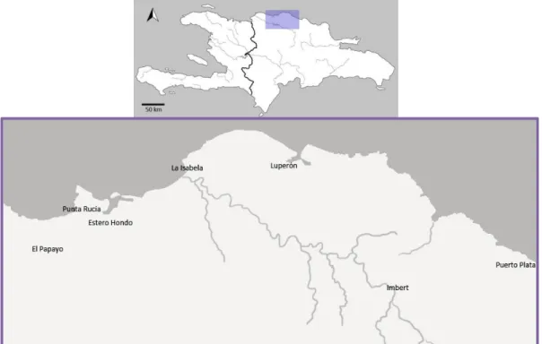
Figure 1. P13: Above a map of Hispaniola with the research area highlighted, and an enlargement of thehighlighted area with the location of villages below.
Figure 2. P22: A southeast facing view of the valley, from the site Los Mangos.
Figure 3. P23: Adapted Landsat7 Imagery with the location of La Isabela and the research area highlighted.
Figure 4. P26: Northeastern view from Los Muertos.
Figure 5. P27: Map of geomorpohological profiles in the area.
Figure 6. P29: Ostionoid ceramics on the left and Meillacoid ceramics on the right. Adapted and enhanced image, photographs taken by Jorge Ulloa Hung.
Figure 7. P31: Meillacoid ceramics (A) and typical Chicoid ceramics (B).
Adapted and enhanced image, photographs taken by Jorge Ulloa Hung.
Figure 8. P32: Part of the map on which Ortega marked the route by Columbus (after Ortega 1988).
Figure 9. P34: The merge of Ostionoid and Meillacoid traits. Adapted and enhanced image, photographss taken by Jorge Ulloa Hung.
Figure 10. P43: A typical huacero pit located on the slope of the Humilde Lopez site.
Figure 11. P45: Standardized form used in the field.
Figure 12. P47: Overview of the pull-down menu’s used in the analysis-database.
7
Figure 14. P50: 3D model of the research area created in Surfer, viewed from the northwest.
Figure 15. P54: Snippet of the military map in the area of Punta Rucia.
Figure 16. P55: Geomorphological map on the left, and vegetation map on the right.
Figure 17. P56: Aerial photograph of Punta Rucia in the top image, and a 100% zoom level in the bottom picture (adapted image from Instituto Nacional de Recursos Hidráulicos; 2000)
Figure 18. P57: Overview map of all sites, numbered.
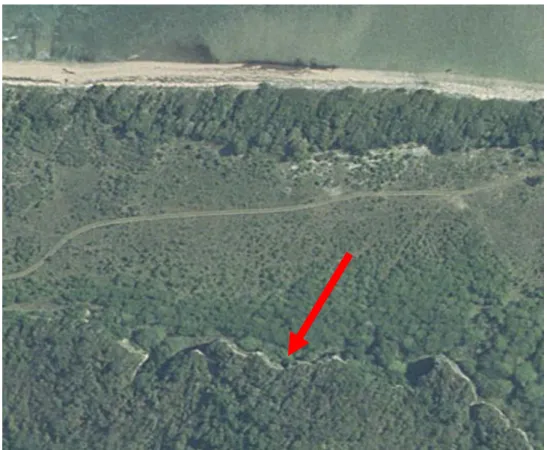
Figure 19. P59: Aerial photograph of the site area of El Burén, with the limestone cliffs indicated.
Figure 20. P60: Overview map with Meillacoid sites highlighted.
Figure 21. P61: Stone slabs on the slope of mound 7, Los Perez.
Figure 22. P64: Contour map of Popi (Ulloa Hung, in press).
Figure 23. P67: Overview map with Chicoid sites highlighted.
Figure 24. P69: Aerial photograph of Persio Polanco, where the bulldozed area is clearly visible on the western side (INDHRI 2000).
Figure 25. P73: Western view from La Muchacha.
Figure 26. P82: Map with locations of Meillacoid (red) and Chicoid sites (blue).
Figure 27. P84: Presence of mounds on the sites highlighted in red.
8
Figure 29. P89: Visualizations of the links between sites, created with Visone 2.6.5. Chicoid sites and links in blue, Meillacoid sites and links in red, Chicoid-Meillacoid links in purple, and unknown sites and links in pink.
Figure 30. P91: Overview of the locations of the site-plan images indicated in red on cut outs of the military map.
Figure 31. P92: Site plans of Chicoid sites Rafo, El Rastrillo and Elida.
Figure 32. P93: Site plan of Chicoid site Persio Polanco.
Figure 33. P94: Site plan of Los Perez.
9
L
IST OF TABLES
Table 1. P58: Overview of sites, site numbers, altitudes and coordinates.
Table 2. P81: Number of sites present in different geomorphological profiles.
Table 3. P83: Distance to ocean and fresh water for Meillacoid sites.
Table 4. P83: Distance to ocean and fresh water of Chicoid sites.
Table 5. P85: Overview of all sites, with radiocarbon dates, percentages of ceramics from a different style than the predominant one at the site (after Ulloa Hung, in press), and locational factors. C=Chicoid, M=Meillacoid, A=Archaic, O=Ostionoid U=Unknown.
Table 6. P87: Average amount of sites within 2,5 and 1,5 km radii.
10
L
IST OF APPENDICES
Appendix 1 P 119: Composed image of military maps.
Appendix 2 P 120: Microsoft Access 2003 database entry form
Appendix 3 P 121: Overview table of sites
11
A
CKNOWLEDGEMENTS
I owe thanks to many people for helping me in writing this thesis, as well as for their participation in the fieldwork, and general support. I especially thank my supervisor Prof. Dr. Corinne Hofman, without whose guidance this thesis could not have been written, for giving me the opportunity to conduct my own research and fieldwork. Also I would like to express gratitude to all of the members of the Caribbean Research Group for their feedback on my presentations and writings. One of the most important people in this study has been Jorge Ulloa Hung, with whom I collaborated on several articles and presentations, and conducted the fieldwork with in 2010. I thank him for his guidance, assistance, and discussions on all the interesting aspects ‘our’ region has given us. Adriano Rivera and José Medina have also played a very important role during the fieldwork, by sharing their knowledge of the region and getting us acquainted with local landowners. Furthermore I want to thank Marlieke Ernst and especially Danielle Meuleman, who were also members of the fieldwork team. I would also like to express my gratitude to Marlies van Vuuren for accompanying us, Marthia Fuller - one of the greatest people I have ever met as well as Micheal Gunther and Tazbah Chavez who always lightened up my evening after returning from hours of exhausting surveys. You made the rough conditions of our fieldwork quite bearable! I would like to express my gratitude to Alice Samson for her guidance. Furthermore, her work in El Cabo inspired me to continue to pursue research. I thank Amanda Guzman for correcting my English, and Maria-Eugenia Sesmilo for helping me with my resumen.
13
1
I
NTRODUCTION
1.1
I
NTRODUCTIONThe Dominican Republic has been the focus of a great amount of research in the Greater Antilles and the Caribbean area in general. In this study, ambitiously titled Mapping History, past social landscapes on the border of the northwestern provinces of the Dominican Republic (Figure 1) - Monte Christi and Puerto Plata - are mapped by using archaeological data, present-day maps combined with GPS data, and ethnohistoric accounts of the sites in the region. This pilot study provides a Geographical Information System (GIS) database containing the known sites in the region, which will be a first set-up for a more widely used database. Such a national database promotes the implementation of Cultural Heritage Management programmes, which is essential for the protection of cultural heritage.
14
In recent decades, computer applications have increasingly become an essential element in the field of archaeology. Archaeologists have gained access to a whole new range of data analysis with the aid of different types of spatial analyses, viewshed analyses and other forms of geoinformatics. This line of data analysis is arguably suitable for a study of the social landscape though the pitfalls will be addressed and elaborated on in the following chapters. ‘Social landscape’ is a very broad term, which encompasses the physical as well as the social spaces that people inhabit. The people residing in this social landscape do not necessarily form a homogenous community; in fact, the various social relations existing within a given society allow for differences within and between its members (Torres 2010). Through such an analysis of the studied area a better conception of the past social landscape will emerge. Equally importantly, information will be permanently recorded in a database. This is of major importance in the region, as well as on most of the Caribbean islands.
A study of the past social landscape is fundamental to understanding how sites and in turn the people might have been interrelated. Mapping the social landscape and creating a GIS of the region will clarify the interesting mix of different ceramic styles all over the region and within sites. Archaeological research in the northwest of the Dominican Republic is rather scarce in comparison to the eastern part of the island, but there are several publications on sites in the region. Among others, Marcio Veloz Maggiolo and Elpidio Ortega provide a clear overview of the sites in the region around Puerto Plata, and show the great diversity of types of pottery styles within and between them (Ortega 2005; Veloz Maggiolo et al. 1981).
15
area is set on a diverse ecological landscape, which makes the area suitable for specific analyses by combining archaeological with ecological factors, enabling patterns in human-land relations to emerge.
16
1.2
R
ESEARCHQ
UESTIONSThe following research questions have been formed or reshaped after some initial data collection and an exploratory visit to the area.
The main research question to be addressed is:
“What can site characteristics and certain patterns in site locations reveal about the social landscape in the past?”
The sub questions are:
1) In what kind of environments are the sites located? -What is the geomorphological setting? -What is the ecological setting?
-Is there a specific kind of site (ceremonial, settlement etcetera) linked to a specific setting?
2) Is there a pattern visible in the location of (or the combination of) sites with either
predominantly Meillacoid or Chicoid ceramics? -What are the specific site characteristics?
3) Is there an indication that visibility played a role in site location? What role could this visibility play?
17
1.3
R
ESEARCHA
IMSMost research conducted in the Dominican Republic has been in the southern and southwestern provinces of the island. A thorough overview and characterization of sites in the northwestern part of the country was lacking. The aim of both Ulloa Hung and myself has been to fill this gap and to produce a coherent and inclusive regional vision. With the aid of extensive surveys and a widely used database it is possible to address the research questions and to come to such an inclusive regional vision. This results in the unveiling of the social landscape. In all, the source of interest is twofold: a scientific analysis of the archaeological landscape which sheds light on matters of interaction and patterning, and the creation and use of a general database. The archaeological landscape has been the main focus of this research, leaving questions concerning different computer applications in the periphery.
1.4
S
CIENTIFIC ANDS
OCIETALR
ELEVANCEThere are important objectives besides the scientific and archaeological value of this research. The creation of a database in collaboration with the Museo del Hombre Dominicano in January 2010 was set up in such a manner that this database can be used nationally, by professional archaeologists as well as by local amateur archaeologists. Information on excavations, specific finds, or literature can be entered into this database. An important aspect of creating a database and map of the sites in the region is the recording and storage of information that might be lost in the near future. Not only hurricanes, erosion, agriculture or urban growth are endangering the maintenance of the archaeological resources in the Caribbean area, but also developments in the tourist industry are a major threat to the archaeological heritage. These threats are some of the reasons why databases are built; the realization that archaeological resources are finite is a catalyst for the creation of these types of recording methods. Once a site is destroyed, it becomes impossible to retrieve contextual information, and it will be a loss for the archaeological record and our knowledge of the human past.
18
NGO’s which may be consulted for advice, but often it is the case that these laws are not enforced (Farmer 2011). Esteban Prieto Vicioso recently published a chapter on the current state of the protection of heritage in the Dominican Republic. Although the chapter consists of an overview of laws and institutions dealing with this subject, Prieto Vicioso concludes that Dominican legislation is as of yet deficient, primarily because of the lack of enforcement of the legislation (Prieto Vicioso 2011). Ulloa Hung has also recently published on the status and the protection of Dominican heritage, but more from a social point of view instead of a legislative one (Ulloa Hung 2010). It is clear that creating a CRM programme based on GIS and predictive modelling is a first step towards the better treatment of the archaeological record.
This research will not only add to our knowledge about the past inhabitants of the region, but will also help to preserve the archaeological record. Eventually, CRM programmes can be developed, but this calls for a rise in local awareness of the importance of the heritage. Education plays a role in this awareness, and is a key factor in developing a sustainable heritage management policy. Although local interest in archaeology is divided between huaceros who loot for money and collectors or amateur archaeologists, the efforts of certain local people like Adriano Rivera, who has turned his house and garden into a small archaeological museum as did several other people in the area, enable next generations to continue a local interest in archaeology and in their heritage.
1.5
A
PPROACH19
taken into account. Both GIS applications and fieldwork observations are utilized to address the research questions. Although this does not address the worldview of past people, with this approach the human perception is partially incorporated in the analyses.
1.6
T
HESISO
UTLINEThe introductory chapter includes the general aims and questions of this study as well as the scientific and societal relevance. The outline and objectives are discussed and will function as a guideline while reading this thesis. The following chapter will focus on the North-western Dominican Republic, discussing the reasons for the selection as well as for the delimitation of the study area. There are several ethnohistoric sources available from the area which mention the landscape or other relevant aspects. Furthermore, previous studies in the area will be discussed in the second chapter. These include not only studies performed directly in the area, but also refer to the area such as Daniel Koski-Karrell’s research in northern Haiti. Lastly, a sketch of the physical and the cultural landscape will be drawn. The physical landscape needs to be described with both facts about for example the different types of vegetation in the area, and with the possible experiences of being there. To find a balance between these two aspects has proven to be difficult. The cultural landscape will be described by the presence of different ceramic styles recently studied by Jorge Ulloa Hung, as well as by the results of previous studies about these styles in the area.
The methods and theories used will be discussed in Chapter 3. The methods of surveying and excavation during our fieldwork are explained, and the resulting database and GIS are thoroughly discussed. The focus in the section on theories of the landscape is mainly on archaeology and settlement patterning. However, during the fieldwork the importance of experiencing the landscape became clear, which led to perception changes of myself. This process is also discussed in Chapter 3. The available and used dataset is covered in Chapter 4. This dataset consists of the different maps used for the creation of the GIS, and of the fieldwork data. Each known and visited site in the area will be described in terms of their setting in the landscape, their size, the distribution of ceramics and other artefacts, and any other specific characteristics.
20
21
2
T
HE NORTHWESTERN
D
OMINICAN
R
EPUBLIC
2.1
I
NTRODUCTION22
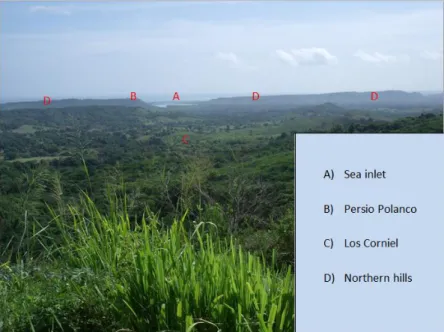
Figure 2. A southeast facing view of the valley, from the site Los Mangos.
This area, with a northern view of the Atlantic Ocean, valleys with sloping hills to the east and west, and a southern view of the mountain ranges (Figure 2), was chosen by Christopher Columbus on his second voyage to come to land. Nowadays the area is still largely intact, particularly in comparison with other mainly coastal areas of the country. The region is scattered with small villages or single houses along unpaved roads, used for motorized traffic as well as for horses and cattle. The town Punta Rucia, where the fieldwork group stayed in the summer of 2010, normally houses no more than 250 people, although it is occasionally swamped with tourists on a trip. There is no public transportation going in or out, and the only place with a cell phone signal in the area is on a hill outside of town. Apart from a small shop or colmado near the beach, the nearest supermarket is in Estero Hondo, a town 8 km away along the road. Currently tourism has not left its footprints in this area yet, but this is likely to change with the ever growing tourist industry and the development of hotels and golf courses.
23
2.2
E
THNOHISTORICA
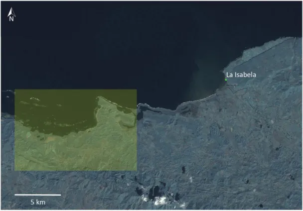
CCOUNTSThe northern coast of Hispaniola is well known for the encounters during the arrival of Europeans in the area. After nearly three months at sea Christopher Columbus and his approximately 1500 men went ashore at the bay of what he named La Isabela, after the Queen of Spain, in December 1493 (Deagan and Cruxent 2002a). It is now known as the first town of the New World, and is located in the vicinity of the research area (Figure 3). Columbus stated that this site was the “best suited spot and better than any other in the land; and this must be believed”. However, it is most likely that the bay was chosen rather hastily because the crew was weary and there was illness among the people and animals on the ships (Deagan and Cruxent 2002b, 47).
Figure 3. Adapted Landsat7 Imagery with the location of La Isabela and the research area highlighted.
24
described how the indigenous people procure things from the forest in a sustainable way, to exchange these with inhabitants of the neighboring islands (Martir 1964,124). On the geopolitical division of northern Hispaniola Martire has written the following (author’s translation):
“In the province of Huhabo are the regions of Xamaná, Canabacoa,
Cuhabo and many others whose names I do not know until today. Those of Cayabo include Maguá and Cocacubana. The inhabitants of this region speak a language very different from the others on Hispaniola, and call it “macoryxes”. Other regions are Cubana, the language also being different from the other, Baioháigua, in which occurs the same, Dahaboon and Cybaho and Manabaho. Cotoy is in the middle of the island and across the river Nizao, its hills are called Mahaítin, Hazúa and Neibamáo ..“ (Martir 1964, 356).
“There is in Hispaniola, in the territory of the old chief, a tree called “macorix”, which still retains the name of the region, and it has a thick top. At
the ends of its branches there is cotton no less useful than the seed, planted each year” (Martir 1964, 638).
This excerpt reveals a diverse depiction of the region, describing the existence of different languages and regional identity. The accounts of Gonzalo Fernando de Oviedo, a Spanish chronicler born in the fifteenth century, are even more verbose on these topics in his La Historia general de las Indias (Oviedo 1988). Oviedo describes where the indigenous people were located (author’s translation):
“The Indians on the island of Haiti or Hispaniola live on the coast or along rivers, or near the sea,[…] , and in high places and in the plains, valleys or forests, […]. And along their places they had their crops and conucos ..., of corn and cassava, and fruit trees” (Oviedo 1988, 183).
Similar to Martir, Oviedo also describes the rivers of the island. About the Yaque river, located west to southwest of the research area, he has written the following (author’s translation):
25
Friar Bartolomé de las Casas, now known for his opposition to the treatment of the Indians at the time, was born in the late fifteenth century in Spain and came to live on Hispaniola before he was 20 years old. After years of exploiting the Indians, Las Casas’ perception of the indigenous people altered and he started arguing on behalf of the Indians. Among other chronicles, he has written Apologética Historia de Las Indias, in which he describes the provinces located in the north of Hispaniola. These descriptions are full of beautiful landscapes, fertile fields, gracious rivers, and landscape features such as salt plains. In his writing on the area of the Yaque river, located west of the research area, Las Casas recounts a salina in the vicinity, as did Oviedo.
In his Historia de Las indias, Las Casas describes a valley in the north, which is similar to other of his descriptions of valleys (author’s translation):
“[…] This port is the ridge mentioned above, fertile, which makes the
plains by the north, which was all settled, but for the part where they were, there ought to be a deserted road; however it was all within walking distance, because it could not be more than eight or ten leagues to descend in the valley down below, which was so admirably populated” (Las Casas 1988b, 361).
He further recounts the difficulties encountered while traveling in the northern region and further inland, where the reception of the indigenous people was not always hospitable. Las Casas also mentions the Macorix ethnic group, living in the Vega Real, as well as ‘three or four or a few more’ languages (Las Casas 1988b, 408). This is described in Apologética Historia de Las Indias (author’s translation):
“There were three different languages on the island, which were not understood by the others: one was from the Macorix de Abajo, another from the Macorix de Arriba… The other was the universal language of all land, and this
was more elegant with better words and a sweet sound […].” (Las Casas 1988a, 620).
26
2.3
P
HYSICALE
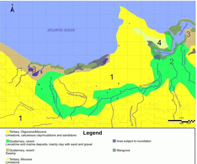
NVIRONMENTAccording to the current regional division the area in which the recent surveys took place is part of the north-central Cibao region (Santillana 2002, 37). The research area comprises approximately 6 by 13 km, or circa 80 km². In this relatively small area there is a diverse landscape, ranging from sea-level mangroves and swamps to high hilltops several kilometres inland, enclosing lower hills and depressions in the valleys. The area is surrounded by the higher hilltops of the Cordillera Septentrional in the southern and western part. A line of medium-high hills at the coast surrounds the area in the northeast. The Cordillera Septentrional is one of the most important mountain ranges of the Dominican Republic. Located in the north, it extends circa 200 km in the northwest - southeast direction from the area of the city of Montecristi in the west to the town of Nagua in the East. It is separated from the Atlantic Ocean by a narrow coastal plain which forms a corridor, which constituted a significant area for the indigenous habitation and it is indeed one of the main areas of concentration of archaeological sites. The Cordillera Septentrional separates the coastal plain and the region of the Cibao-Vega Real valleys. The climate in the study area is predominantly humid, except at its western end at the border between the province of Montecristi and Puerto Plata, where it is semiarid. Corresponding to the climate, the predominant type of vegetation is subtropical rainforest, tempered by mountain areas where it reaches the category of mountain wet forest (Santillana 2002, 40). It is a fairly ‘open’ landscape, the vegetation is not too dense, on most locations, and intervisibility is high because of the lightly sloping character of the area. Currently the land is mostly used by the local people to let their cattle graze, and to a lesser extent for agricultural purposes.
27
The geology of the research area dates from the Tertiary and Quaternary period, and consists predominantly of limestone, lacustrine and marine deposits. The study area comprises three major regions, the plains of Puerto Plata, the Bajabonico Plain and the Cordillera Septentrional. The first two coastal plains are irrigated by two key streams and their tributaries, the Bajabonico river and the Camú river, which flow into the Atlantic Ocean.
The soil on the narrow strip that runs along the northern slope of the Cordillera Septentrional consists of different types. In figure 5 the four different geomorphological profiles in the research area are indicated by the numbers and different colours. Dating further back, area three (9% of the area) is formed in the Quaternary period and consists of swamps. These coastal marshes extend from the town El Cacao to Punta Rucia. The soils are associated with permanently flooded areas subject to tidal influence. Its texture is clay loam with predominantly halophytic vegetation (Tirado 2003). Area 2 (24% of the area) consisting of lacustrine and marine deposits also dates to the Quaternary period.
Figure 5. Map of geomorpohological profiles in the area.
28
These consist mainly of clay with sand and gravel. Area number 4 (3% of the area) represents a Miocene deposit of limestone, and area one (64% of the area) represents an Oligocene mix of limestone, calcareous clay and sandstone; both dating from the Tertiary period. The yellow residual soils occur both deep and shallow in the area, and are formed by the deposition of calcareous materials. These clay soils have a brown or reddish colour and are of certain importance to agriculture (Tirado 2003). In areas closer to the shoreline soils are usually red and consist of hard limestone, while in the inland areas they are grey and formed by non-hardened calcareous material. The soils in the area are fit for agriculture, although the possibilities are limited. However, the presence of mangroves and swamp areas make the area perfectly fit for the collections of shells for dietary or utilitarian purposes.
29
2.4
C
ULTURALE
NVIRONMENTThe existence of stylistic diversity at the intra-regional level was perceived early on by Rouse and Rainey during their studies at Fort-Liberté. The stone and shell artefacts and ceramics were different from those compared to the southeast (Ulloa and De Ruiter 2011). Discussions about this diversity are part of current research. A brief overview of the cultural landscape follows.
Focusing on the ceramic period, the cultural landscape will for the larger part be described using ceramic styles. Ostionoid ceramics appear in eastern Hispaniola at around 600 CE. These ceramics are characterized by polished or smoothed surfaces, surfaces painted with reddish slip, handles in the shape of looped straps, modelled or applied zoomorphic heads and limbs, and simple stylized decoration. Ostionoid ceramics are diagnostic of Ostionan culture (Koski-Karrell 2002), dating roughly from 600 to 1200 CE (Rouse 1992).The settlement sites are characterized by the presence of redware pottery and griddles. As noted by Veloz Maggiolo, Ortega and Caba Fuentes in Modos de Vida Meillacoides, the Ostionan components in northern Hispaniola are ephemeral and contemporaneous with or succeeded by Meillacoid components (Veloz Maggiolo, et al. 1981).
30
The aforementioned authors also suggest that the Meillacoid cultural expressions seem to originate in northern Hispaniola. This will be discussed further in the paragraph below. Meillacoid style ceramics are usually hard, have thin walls, are not polished but smoothed, with a greyish-brown paste. One of the most distinct features of Meillacoid pottery is the cross-hatch pattern, either incised or applied (Figure 6). Zoomorphic features are also common in Meillacoid pottery, and consists of heads, limbs, and other body features. Although many things are unclear about the Meillacoid series, there are indications that the socio-political organization resembles an egalitarian village-based system where the subsistence in based on agriculture. Settlement sites are characterized by the presence of marine shells, suggesting that the collection of shellfish was an important subsistence practice. Calibrated radiocarbon dates on sites with predominantly Meillacoid style ceramics in the research area were between 1019 and 1394 CE.
Chicoid style ceramics, named after the Boca Chica site in southeastern Hispaniola where the style was first reported, emerge at around 900 CE, although the spread to the northwest occurs later. It was argued by Rouse that the Chicoid culture occupied a vast territory spanning from eastern Cuba up to the Virgin Islands, and covering nearly all of Hispaniola (Rouse 1992). Archaeological studies indicated that Meillacoid and Chicoid series were contemporaneously in certain places, among which the research area (Moore 1997). As discussed in paragraph 2, the chroniclers also recount what could be called a melting pot. The idea that Chicoid groups simply replaced Meillacoid groups is clearly oversimplified.
31
Figure 7. Meillacoid ceramics (A) and typical Chicoid ceramics (B). Adapted and enhanced image, photographs taken by Jorge Ulloa Hung.
2.5
S
TUDIES IN THEP
UNTAR
UCIAA
REAThere have been several archaeological studies in the research area, or the in the vicinity of it. From over a century ago up to the present the area has proven to contain large amounts of archaeological material, covering both pre-Columbian and colonial times. As an archaeologically relatively intact region, archaeology in the northern area of Hispaniola will undoubtedly yield much more in the coming decades.
2.5.1 PREVIOUS STUDIES
The northern region of Hispaniola has been a focus for pioneering archaeological research in the Caribbean by De Booy, Shomburg, Fewkes, and Krieger. In these early descriptions, archaeological approaches were combined with other scientific interests (Ulloa and De Ruiter 2011). This led to an initial characterization of the region from different points of view. After this the studies focused particularly on archaeology in northern Haiti, especially in the region of Fort Liberté (Rainey 1941; Rouse 1939, 1941), located on the western side of the border between Haiti and the Dominican Republic. These studies served as a base for the methodological and conceptual model by Rouse in which he characterized West Indian ceramics and the developed theoretical framework defining the indigenous cultures of the region.
32
1988; Rothschild, Luna Calderon, Coppa and Rothschild, 2000; VanderVeen 2006; Vega 1990; Veloz Maggiolo 2002; Wilson 1992). The main focus of these studies is on the first European colonial enclaves in the West Indies, in particular La Isabela, En Bas Saline, and Puerto Real, with general archaeological references to its surroundings in an attempt to contextualize the social and cultural space in which the first Spanish villas were located (Cusick 1991; Deagan 1995; Deagan and Cruxent, 2002).
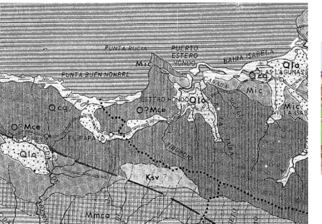
Another approach often taken in the region is to try to link archaeological data with ethnohistoric accounts, which was conducted by for example Elpidio Ortega. Ortega´s study is an archaeological exploration along the route of Christopher Columbus (Figure 8), this trail runs from La Isabela to the Cibao Valley (Ortega 1988).
Figure 8. Part of the map on which Ortega marked the route by
33
Guerrero and Veloz Maggiolo have attempted to attribute the Meillacoid ceramic style to the aforementioned Macorix group described in the Chronicles (Guerrero and Veloz Maggiolo 1988). In Wilson’s 1992 publication Hispaniola: Caribbean Chiefdoms in the Age of Columbus the complexity and integration of chiefdoms are studied using historical sources from the early colonial times. More recently archaeometric methods were applied for studies on the diet, in order to reveal interactions between indigenous people and Europeans (VanderVeen 2006). Most archaeological studies in the north of Hispaniola have been primarily focused on isolated sites (De Grossi et al. 2008; Luna Calderón 1973; Olsen 2000; Ortega 1981, 1988; Ortega and Veloz Maggiolo 1972; Ortega et al. 1990; Veloz Maggiolo 1972a, 2002; Veloz et al. 1981), which has created the absence of a coherent and inclusive regional vision.
2.5.2 RECENT STUDIES
34
context. The differences are observed not only at the decorative attribute level but also in other technological and formal aspects (Figure 9).
This gradual combination of the two ceramic styles in the area is retraceable through a consistent combination of attributes through time, and was thus a graded continuum. The fully combined expressions are what most consider Hispaniolan Meillacoid, which presents differences as well as similarities to the Meillacoid style ceramics in for example Jamaica or Cuba (Ulloa Hung, in press). Hispaniolan Meillacoid is marked by the presence of the Ostionoid technological expressions of appliqués, which can be very characteristic. This reflects the different historical processes for each island or island region. The gradual process of the merging of the two ceramic traditions is expressed in different phases at various sites in the northeast of Hispaniola (Ulloa Hung, in press). However, in the study area we only see the result of the final process, at the Meillacoid sites Don Julio, Puerto Juanita, Los Perez, Popi and Humilde Lopez.
Figure 9. The merge of Ostionoid and Meillacoid traits.
Adapted and enhanced image, photographs taken by Jorge Ulloa Hung.
35
37
3
T
HEORIES &
M
ETHODS
3.1
I
NTRODUCTIONTwo factors play a central role in this research: the fieldwork data and experiences, and the computer-analyses. In this chapter applicable theories are described, followed by the choices of the used methods. This extensive explanation is important because the focus of this research, and therefore the methods as well as the theoretical approach, has changed during the process of writing this thesis.
Theories on landscape archaeology have always varied widely: from one end of the spectrum, analysis of the hard data on the landscape comprising particularly ecological variables, to the other, analysis of ‘experiencing the landscape’ or a more phenomenological approach. There are many approaches to the landscape, the main difference lies in the focus of these approaches (Anschuetz et al. 2001; Cooper 2007; De Waal 2006; Fitzjohn 2007, Ingold 1993; Johnston1998; Reid 2008; Witcher 1999). A broad approach, encompassing the entire aforementioned spectrum, is necessary for a study of the social landscape. The intention was to adopt a hard-data analysis approach, which is evident from the initial plan to rely on computer applications in order to address the research questions. However, after several days in the field it became clear that this would not be sufficient to come to conclusions. The focus of research has somewhat shifted in order to combine these two different approaches. This process, and this shift, will be explained in the Theories section below.
38
was created with the fieldwork data and the collected maps. Different GIS-programs were used for different purposes. The methods section concludes with the description of the computer applications used.
3.2
T
HEORIES ONL
ANDSCAPEA
RCHAEOLOGYA short overview of the developments and the current state of affairs in landscape archaeology and settlement patterning is discussed, focusing on specific studies and methods used. The following section will focus on the current state of affairs of these topics in the research area.
3.2.1 LANDSCAPE ARCHAEOLOGY AND SETTLEMENT PATTERNING
Starting with New Archaeology in the 1960s, the landscape was viewed as one of the factors in a system, with a focus on ecology. Movement, settlement and other human activity was explained with empirical evidence on different scales, from the artefact, to the site, to the landscape. Instead of the mere descriptive documentation of a site or a region, interpretation of multivariate dynamics underlying certain observed patterns became the way to conduct archaeological research. According to Clarke (Clarke 1968) and Johnson (Johnson 1977) among others, the interaction of different factors on different scales would allow for a more comprehensive understanding of patterns of change. A well-known proponent of New Archaeology, Lewis Binford stated that the landscape, not the site, is the arena for all human activities. He argues for a multiscalar approach, within and between sites, to come to a systemization of settlement pattern studies (Binford 1982). Binford’s views on the importance of context have had profound effect on landscape archaeology and archaeology in general. However, these systems approaches could only the how, and not the why.
39
the landscape is constituted as an enduring record of the lives and actions that have taken place of the past people who have dwelt within it. Through their lives and their actions, these people have left something of themselves there. The landscape does not just tell a story, it is a story (Ingold 1993). This recent approach towards the human experience in the past has made landscape archaeology all the more complex. The historical and economic component of the landscape have been replaced by a human socio-symbolic component. More recent research by Joshua Torres on the landscape surrounding Tibes, Puerto Rico (Torres 2010) attempts to approach the social landscape methodologically, focussing on the relations between sites and areas. Although the socio-symbolic factors are mentioned, the study results in a categorization of sites in the landscape.
Although landscape archaeology and settlement patterning studies are not as widely applied in the New World as they are in the Old World, there have been some major studies since the 1940’s. Gordon R. Willey’s 1953 publication on prehistoric settlement patterns in the Virú valley in Peru was one of these which was conducted on a regional scale and focussed on the description of a set of specific site characteristics (Willey 1953), in line with the archaeological theory in that period. Studies on a regional scale in the 1950’s and 1960’s generally adopted the cultural-historical descriptive approach. An important and exemplary study from the next theoretical era, known as processualism or New Archaeology, is Kent Flannery’s 1976 The Early Mesoamerican Village. Flannery’s goal was not only to create a model of Early Formative society based on substantive data, but also to produce “analytic procedures for sampling and studying Formative cultures” on different levels (Flannery 2009). Processualist studies focus on systematically acquiring hard data which led to the postprocessualist critique of the obliteration of the human factor in developing our understandings of the past. However, this more interpretive approach does not necessarily exclude the ecological factor. Current studies on landscape and settlement patterning often apply computer applications for analysis, which is why they tend to focus more on ecological factors.
40
approach resulted in a more dynamic and diverse view of the Caribbean, in contrast to that of Rouse. One of the more recent large scale study on landscape and settlement patterning, albeit across the border, was conducted by Daniel Koski-Karrell, in which sites were mapped along the northern coast of Haiti. Koski-Karrell used similar categorizations as were used in this study, which make them quite comparable. Koski-Karrell’s work will be further addressed throughout this thesis. Maaike de Waal’s study on social interaction and settlement patterns on La Désirade and on Guadeloupe (De Waal 2006) and Alistair Bright’s dissertation on inter- and intra- insular relationships in the Windward islands (Bright 2011) are some of the most recent studies (at least partly) on settlement patterning in the Caribbean.
Current research on landscape archaeology and settlement patterning shows a diversity of approaches, both processual and postprocessual, often using GIS for analyses. Jago Coopers’ review of pre-Columbian Cuban archaeology included an analysis of settlement patterning with the aid of a GIS. Although the overview was very thorough, interpretations were feeble due to the biased information incorporated in the GIS (Cooper 2010). Difficulties concerning the limitations of these analyses can be overcome with creative new approaches such as Fitzjohn’s study on the perception of space in the mountains of Sicily (Fitzjohn 2007). In this study he explores the use and value of methods of analysis widely used by archaeologists by incorporating perception and experience of local farmers into his research. Approaches such as these will bring landscape archaeology, settlement patterning and the use of GIS to the next level.
41
3.3
T
HEORETICALA
PPROACH:
E
XPERIENCES ANDP
ERCEPTIONC
HANGESIn the process of writing this thesis it was striking to realize that the four-decade spanning journey from processualism toward post-processualism was unintentionally also undertaken in my own approach. Commencing with the notion that hard data and computer-models will unveil the social landscape of this small area, this was revealed to be insufficient. There are many variables which cannot be included in a computer model, and the most relevant one is experiencing the landscape. Certain patterns might emerge from the data collected, all based on these measurable variables. These variables play a certain role, but it has to be made clear that many other factors such as animism, which is believed to have been a key factor of life in the pre-Columbian Caribbean, have played an important part in for example site location.
While computer models are useful for the characterization of a region or area, the use for analyses must be questioned. When computer models are used for analysis it has to be made clear why these analyses are performed. What would it actually mean that route X is the shortest or fastest route from point A to point B? It is merely a computer model which does not necessarily reflect routes taken by people in the past. In fact, what is available in archaeological data is point A and point B. How these are connected or what the relation is between these two cannot be concluded from computer models based on location, distances and slopes. At the very least other variables must be included, such as indications of mobility and/or exchange between the two. It has become increasingly clear that mobility and exchange have played an important role in the life of Amerindians, whether this was on a day-to-day basis or as part of a larger network (e.g. Hofman et al. 2007; Hofman and Hoogland 2011).
42
of) the views, a 3D computer model was necessary to reconstruct what is visible from which site. This is further explored and explained in chapters 5 and 6.
The experience of navigating through the landscape has changed my views on many aspects of this thesis. The focus is shifted from GIS analyses towards experiencing the landscape. However, this can only be described and cannot be analysed. Answering the research questions is possible by analysing the characterizations made while taking the site descriptions into account. To retrieve the experiences of the past people archaeologically is impossible. However, some variables and patterns emerging from analyses can generate possible priorities and preferences of specific peoples.
3.4
M
ETHODSAs preparatory work a study of the available literature on archaeological sites in the area is essential in the first phase of this research. With the aid of the Museo del Hombre Dominicano a list of known sites was compiled from archaeological as well as from ethnohistoric sources. This provides the information that is necessary to determine the possibilities for fieldwork in the area, and has helped to estimate possibilities of the extent of the research area. Several different maps had to be retrieved, many of them only available in the Dominican Republic, and some of them on the internet or at the Leiden University Library. A preparatory visit was made by myself in January 2010. The aim of this visit was to retrieve maps, get acquainted with the research area, and to meet local archaeologists who would work on this combined project. The next step in the preparatory work was to digitize the collected maps, in order have a properly working GIS of the area when the fieldwork commenced. Due to difficulties with the digitizing tablets and with importing the map from AutoCAD into MapInfo, this was partially completed in advance.
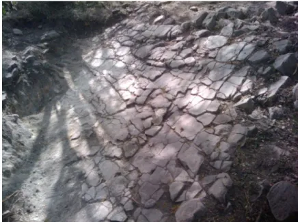
3.4.1 SURVEY
43
agriculture. People in the area generally live off their own land with a few animals, crops and fruit trees to sustain them. Local inhabitants know their lands well, and archaeological material hardly goes unnoticed: this has proven to be a lucrative way of earning money. Huaceros or looters are very active in the area. Every single one of the sites visited had been visited by looters as well (Figure 10), with distinctively dug pits at strategic points on a site left behind as evidence for these activities. Local knowledge of the presence of archaeological material is reliable; during our great many hikes to a site we have never encountered archaeological material of which the local people had no knowledge.
Figure 10. A typical huacero pit located on the slope of the Humilde Lopez site.
44
corner. The surface surveys took place in a random manner due the irregular vegetation, fences, and slope of the landscape which made a systematic survey impossible.
The standardized A4 form (Figure 11) has been used in the field and during literature studies. It is made in such a general manner that it is suitable to record the observed information on the paper form into the digital database.
In the field the following information was noted when possible:
These variables were not only noted to be used for this study, but also to record information to incorporate in the general database. Variables used for this research are mainly the UTM coordinates, the accessibility, geomorphology, altitude, vegetation, current land-use, complex type, period, and site type. The latter is often a rough estimate based on presumed function and general archaeological character, such as resource extraction sites, settlements, workshops, individual finds, and ritual sites. Observations on the field as well as the material assemblage of the site aid in assigning site types (De Waal 2006). In this section observations on the visibility and specific views were noted. The aforementioned variables are all either environmental factors or influence the human experience of the landscape. For instance, the accessibility, vegetation and visibility might make a site location either beneficial or disadvantageous. Other variables noted, such as depth of finds and number of finds, are in order to preserve information for future research, easily accessible with the database and recorded in a standardized manner.
-Site name -Minimum depth of finds
-UTM Coordinates -Maximum depth of finds
-Place -Find/research area
-Landowner -Maximum depth of research
-Accessibility -Complex type
-Soil -Site type
-Geomorphology -Number of finds
-Altitude AMSL -Material
-Vegetation/Surrounding -Date/Period
45
46
It was rarely ever possible to record information on all these variables due to different circumstances on each site. When one of the variables could not be observed and recorded the cause was explained on the form. Both Ulloa Hung and I used a handheld GPS in the field. The recorded coordinates were compared and reliability was checked on the maps. Due to the type of GPS device which displays the UTM coordinates without the ability to name or record them, the displayed coordinates were copied in a field notebook and on the standardized A4 form, accompanied by a short description.
Shovel-tests and test-pits were dug at several sites. The shovel-tests consist of a shallow, irregular dig, usually with a pick-axe. These tests were not only made to collect material, but also to assess the general area of the site and the best option to dig a 1x1 meter test-pit. Test-pits were 1x1 or 1x2 meters, set out with a measuring tape, and were not aligned to a specific grid; however the coordinates of at least one corner were recorded. The test-pits were divided in layers of 10 cm and finds were bagged accordingly, categorized by material. The contents of the test-pits were sieved in order to retrieve smaller pieces of archaeological material. Excavation ended when the pit-depth had come to the sterile layer. Ulloa Hung made profile drawings and recorded photographs of the profiles. Lastly, soil colour was noted according to the Munsell color chart, and the characterization of the soil texture was recorded. All finds were washed in the Punta Rucia field laboratory with tap water, different sized brushes, and sticks.
3.4.2 DATABASE
Relational databases are the main choice in storing data, especially in archaeology. It is a relational database when relations are assigned between different attributes of several tables. However, these relations and tables are not in a particular order. Geographic Information Systems are map-based databases, systems designed to store, manipulate and analyze all types of geographically referenced data. It is a combination of cartography, statistical analysis and database technology. Computer applications have become an indispensable aspect of archaeological research. Even in for example literature and historical studies a digital database is created and used, thus resulting in mainly digital data storage. Fieldwork carried out with a mere measuring tape and a shovel will eventually be digitized in a text document and a data spreadsheet, before it could ever be published.
47
complicated, time-consuming, and more reliable through the use of forms and within them so-called drop-down menu’s to ensure that all entries in that box will be comparable. For example, for the analysis database the relative approximate altitudes have been categorized into plain, low hill, medium high hill, and high hill. Broad analyses can be made through the use of created queries, of which simple graphs can be made.
The database created for this project was not only built to be used for this research, but also had to be capable to contain research information from other parts of the Dominican Republic, conducted by other researchers. The variables included in the main database are therefore quite general. Although the titles and data-fields are in English, the descriptions of the fields are also in Spanish to enable Spanish-speakers to use the database. An additional database with data fields more specific for the analyses planned for this research was created as well, related to the general database. All recordings on the form were entered into a Microsoft Access 2003 database. It should be noted that this database is mainly used as a recording device, not as a tool to enable comparisons and analyses. The variables are too complex and most of them cannot be converted into a simple drop-down menu, which would enable analyses. However, factors such as geomorphology, relative altitude, slope, the presence of mounds, percentage of visibility, view (direction), and distance to the sea are categorized and can therefore be analysed using the database.
48
As is visible in the database image in figure 12, which is simplified and enhanced, the analytical database contains information on the aforementioned variables, categorized into comparable units of measurement or terms. In the reference table for view on the upper right the E stands for east, the W stands for West, the V for valley, and the O for ocean. The lower right depicts the ranges in the distance to sea, in kilometres. The lower left represents the different categories of geomorphology, in which the number corresponds to the numbers and a specific colour on the maps used in following chapters. The presence of anthropogenic mounds on sites is answered with a simple yes/no.
3.4.3 GEOGRAPHICAL INFORMATION SYSTEM
Geographical Information Systems have become a key aspect in archaeological research. Programmes such as ArcGIS, MapInfo/Pitney Bowes, Surfer, and Idrisi are constantly being developed and updated. Each GIS computer programme has its own specialty; 3D models are best made with Surfer and Idrisi, while Autodesk also allows for digitizing maps through AutoCAD. Currently there are several open source GIS programmes available on the internet, these are for example GRASS, Quantum GIS and MapWindow GIS. The well-known Google Earth is also a GIS programme. Over the last years the interface of these open source programmes has become more user-friendly, which enables utility by a larger group of people. Geographical Information Systems are also used for predictive modelling, a method of which the usability and value is much debated (Verhagen and Whitley 2011; Kamermans 2007; Kvamme 1997).
49
Figure 13 . Moore and Tremmel’s map of archaeological sites in Haiti (after Moore 1997).
On Hispaniola Clark Moore’s online available archaeological database of sites in Haiti is a fine example of an easily accessible and clear national database (Figure 13). Specific characteristics of all sites are recorded, such as the type, culture and area, so there is a short overview of each site in the database. Harold Olsen Bogaert is one of the archaeologists working in the Dominican Republic who has done walkover surveys in several areas ahead of builder development and has recorded the site locations with a GPS, starting a database with site locations used by the Museo del Hombre (pers. comm.). While in Olsen’s and this research several sites located in an area are mapped, Erlend Johnson has mapped specific features in the surrounding area of one site; El Cabo. The site is located on the east coast of the Dominican Republic and has been extensively researched in the past decade by a team from Leiden University under the direction of Dr. Menno Hoogland, producing a complex image of house trajectories (Samson and Hoogland 2007, Samson 2010). Johnson’s study placed the site in the context of its surroundings by surveying with a GPS (Johnson 2009).
50
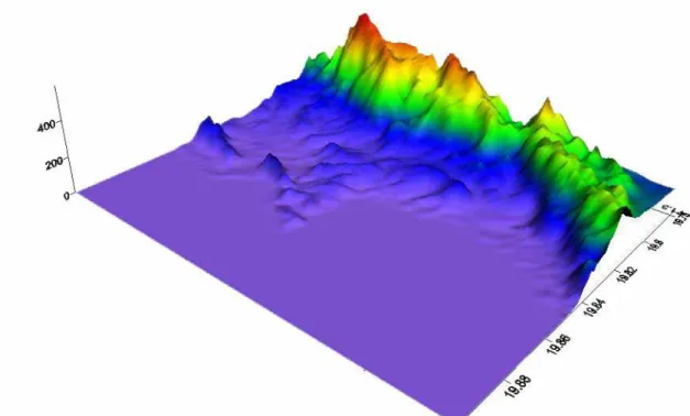
For this research the collected military and soil maps were digitized with AutoCAD 2007 to create a basic map to import into GIS programmes. The data was imported into MapInfo to make a clear and understandable map to use as a basis for images. Aerial photographs were available for only a part of the area and did not provide any significant information, which is why these were not incorporated. 3D Grid data, obtained from the United Stated Geological Survey, was imported into Golden Software Surfer 9.0 (Figure 14) and Global Mapper 10. The interpolation method kriging was used to create the most useful grid-file from which the 3D image below was produced. Such a 3D model enables the execution of viewshed analyses.
Figure 14. 3D model of the research area created in Surfer, viewed from the northwest.
51
3.5
T
HES
OCIALL
ANDSCAPEAfter this thorough discussion of the theories and methods used, the social landscape needs to be addressed. The term social landscape is as broad as it is vague, with different definitions used by different researchers, and often the term is simply used without discussing the definition first. This leaves their readers to guess what the social landscape actually encompasses – even though it is the focus of their study (Adler 1996; Varian 1999). My definition is a rather practical and all-encompassing one: the social landscape is the combination of the physical landscape and the human presence and actions which take place in it. It is viewed truly as a merger of the cultural and the physical aspect. This entails that both empirical data and humanistic or more phenomenological data have to be used and combined where possible. The data used in this research allows merely for a broad-stroked image of the social landscape of a small area in the northwest of the Dominican Republic. On this ‘middle scale’, with small comprising one site and large the whole region, it is hard to place the area as well as specific sites into interaction spheres. Detailed information is lacking on a large majority of the sites, which makes it impossible to look at site-to-site relations. The amount of located sites in the surroundings of the research area is low in comparison with the site density of the area, which makes placing the study area in a larger settlement-patterning context difficult. However, the study area itself is a rather secluded one, encompassed by lines of hills and the ocean. Detailed studies and dense surveys of the surrounding area could shed more light on the actual level of seclusion of the research area.
53
4
S
ITES
& THE
S
URVEYS
4.1
I
NTRODUCTIONThree fieldwork campaigns with different purposes were carried out in the northwest of the Dominican Republic, around the border of the provinces Monte Christi and Puerto Plata. A total of 49 archaeological sites were visited of which 44 are new recordings for this area of the island. Archaeological material was also studied in two existing local collections, the ceramic material was restudied and site reports from the Museo del Hombre from the 1970s and 1980s from the Cibao valley and the province of Montecristi were reviewed.
Eleven sites were surveyed with excavation units of different sizes and seven sites with different cultural components were dated. In the remainder of the sites archaeological material from the surface was collected and all information was recorded on the standardized form in order to be able to analyse the interaction of human groups with the landscape. Thirty sources of clay in the north of the Dominican Republic were located contributing to research on ceramic interactions and mobility (Ulloa Hung, in press). These, along with samples of potsherds from several settlements are under analysis in the Ceramic Laboratory in the Faculty of Archaeology, Leiden University.
54
4.2
M
APD
ATAA very brief overview of the used maps and aerial photographs is described
below. The maps used for this research are military maps and geomorphological
maps. These maps were retrieved in the library of the Museo del Hombre in
January 2010, or via digital source.
4.2.1 MILITARY MAPS
The maps used for the GIS were military maps in Universal Transverse Mercator (UTM) coordinates with a scale of 1:50 000. These military maps, created in 1984 and 1988 are very detailed and reveal a large amount of basic information. Roads, contour lines with 20 meter intervals, buildings, vegetation and other features are indicated on these maps. Although lines on the map, as pictured in figure 15, are at least 2.5 m wide, these maps still form a solid basis to create a GIS. The maps were digitized into AutoCAD 2007, and later imported into other GIS software. The simplified coloured maps, such as figure 18, are all created from the CAD drawing based in these military maps. A composed image of the area is placed in Appendix 1.
55
4.2.2 SOIL MAPS,GEOMORPHOLOGICAL MAPS, AND VEGETATION MAPS
The geomorphological maps incorporated in the GIS are on a scale of 1:250 000, which is rather large and causes a lack of detail. However, for this research and the study area it is acceptable. Sites near the border of two profiles are characterized as profile X+Y in the analyses in Chapter 5. Information on the soils is given in the map legend. This, in combination with Tirado’s publication Los suelos de la Republica Dominicana (Tirado 2003), gives an indication of the soil types in the area.
Vegetation maps could not be obtained on a scale smaller than 1:500 000. This is one of the reasons vegetation is not taken into account in detail. The best vegetation map that could be obtained is shown in figure 16, which is impossible to incorporate into the created GIS. However, the most relevant argument not to take vegetation into account during analyses is because the vegetation can change within a year in the area. Both myself and Ulloa Hung have mistaken their location on different accounts based on vegetation. This was simply because where once was a densely overgrown area with large trees, there was now a completely cut field with young fruit trees planted on it, or in my case, where an easily accessible agricultural field was encountered in January and a completely overgrown, impossible to survey area was encountered in July.
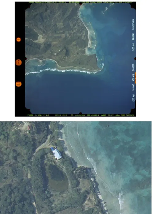
56 4.2.3 AERIAL PHOTOGRAPHS
Aerial photographs on a scale of 1:20 000 are available in digital form of the complete research area, with the exception of a small part of a several hundred square meters. These photos are geo-referenced and can therefore be incorporated into a GIS. The aerial photographs were mainly used to identify a site in the area, or to function as the background of an image. As visible on the bottom picture of figure 17, the zoom level is very high, up to the point where it is possible to distinguish small features such as bushes.