Article
1
Allocation of Tutors and Study Centers in Distance
2
Learning using Geospatial Technologies
3
Shahid Nawaz Khan1, Kamran Mir 2, Ali Tahir 3*, Arshad Awan 4 , Zaib un Nisa 5 and Syeda
4
Aareeba Gillani6.
5
1 Institute of Geographical Information Systems, National University of Sciences and Technology, Pakistan;
6
7
2 Dept. of Computer Sciences, Allama Iqbal Open University, Pakistan; [email protected]
8
3 Institute of Geographical Information Systems, National University of Sciences and Technology, Pakistan;
9
10
4 Dept. of Computer Sciences, Allama Iqbal Open University, Pakistan; [email protected]
11
5 Allama Iqbal Open University, Pakistan and National University of Sciences and technology, Pakistan;
12
13
6 PMAS Arid Agriculture University, Rawalpindi, Pakistan; [email protected]
14
* Correspondence: [email protected]; Tel.: +92-51-9085-4476
15
Abstract: Allama Iqbal Open University (AIOU) is the largest distance learning institute of Pakistan
16
and providing education to 1.4 million students. This is fairly a large setup across the country where
17
students are geographically distributed. Currently the system works on a manual approach which
18
is not efficient. Allocation of tutors and study centers to students plays a key role in distance learning
19
for a better learning environment. Assigning tutors and study centers to distance learning students
20
is a challenging task when there is huge geographical spread. The utilization of geospatial
21
technologies in open and distance learning can fix allocation problems. This research analyzes the
22
real data of twin cities Islamabad and Rawalpindi. The results show that the geospatial technologies
23
can be used for efficient and proper resource utilization and allocation, which in turn can save the
24
time and money. The overall idea fits into improved distance learning framework and related
25
analytics.
26
Keywords: Geospatial Technologies, Distance Learning, Resource Allocation, AIOU
27
28
1. Introduction
29
Distance education is acquired by learner when the opportunity of face to face learning is limited
30
or when there are not enough resources to cater the needs of such learning. There are educational
31
disciplines where there may not be a need of lecture delivering and therefore several ways of
32
communication are used by the educators and distance learners [1]. Many teaching strategies are
33
employed by the distance educators to deliver the content to the distance learners in open and
34
distance learning environment. The continuous growth of distance education has created new
35
opportunities for distance learners and educators. Simultaneously, the continuous improvements for
36
innovation in delivering techniques has also started. The educators have always focused on
37
enhancing interactivity which is vital in open and distance learning. The proliferation of disruptive
38
technologies has created an opportunity to achieve the maximum interaction which is evident from
39
current trends of technology usage in distance learning [2].
40
Allama Iqbal Open University (AIOU)1 is the largest distance education institute in Pakistan
41
which provides distance education to the students in almost every field from higher secondary to
42
doctorate level studies. The university admits candidates in different disciplines such as arts,
43
management and science programs where each student is assigned a tutor who is responsible for
44
marking the student assignments. A tutor is also responsible for formal meetings called workshops
45
in study centers allocated to the students by the university. Currently, the university uses manual
46
system for allocation of students and study centers. Until now, less consideration is given to
47
exploiting locational intelligence of students and study centers. Due to lack of locational intelligence
48
system, this creates many issues for distance learners when they are assigned study centers far away
49
from their home addresses. This also reduces the socialization and interaction on the student’s part.
50
The distance education is an emerging research and development area with the integration of
51
multi-disciplinary approaches and proliferation of disruptive technologies such as advancements in
52
ICT, mobile technologies, internet of things, and location-aware devices in the context of geospatial
53
sciences. In this regard, AIOU has a dire need to make use of above mentioned technologies especially
54
the geospatial technologies in order to make informed decisions for the distance education
55
management for student, tutor and exam-center allocation. The efficient use of geospatial
56
technologies is still lacking in distance education which makes the proposed project very interesting
57
from both commercial and research viewpoint.
58
Geographic Information System (GIS) is a computer based system which is used to manage,
59
store and analyze spatial data [3]. The applications of GIS are almost in every field and can be applied
60
when there is a need to process the data in spatial context. The system is usually a computer based
61
interactive software which is used by the user for making sense of the data and support in decision
62
making. The current research builds on previous work [4], which highlight the importance of GIS
63
based support for students and study center allocation in distance learning. The study is aimed at
64
developing a GIS based System which takes into account the geographical location of students, tutors
65
and study centers and allocates the nearest resources to the students. This increases social aspects by
66
involving in activities organized by AIOU and communicates effectively while learning.
67
The remainder of the paper is as follows: Section 2 elaborates a detailed literature review on
68
distance education and use of technologies. Materials and methods for our proposed approach is
69
outlined in Section 3. Section 4 presents interesting results and findings on the subject. The
70
conclusions and direction to future work are given in Section 5.
71
72
2. Related Work
73
Many studies have been conducted on the problems and issues faced by students in distance
74
learning mode from institution viewpoint. Simultaneously, numerous technological solutions to
75
those problems have been suggested in these studies. Mir (2017) highlighted the importance of
76
systemic support to students in Open and Distance Learning and suggests an online integrated
77
student support system which can reduce the administrative problems of Open and Distance
78
Learning (ODL) students [5]. Beldarrain (2006) pointed out that researchers are always concerned
79
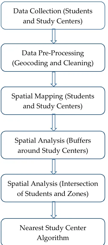
about the problems faced by the distance educators and the student, which needs to be addressed
80
through emerging tools and technologies [6]. The relationship between technology and learning in
81
distance education has been proved [7]. The authors provide in-depth analysis on online learning
82
methodologies including concepts, strategies and applications.
83
Emerging technologies such as Web 2.0 [8], are creating new opportunities for distance
84
educators and learners in real time which is improving the efficiency and overall effectiveness of
85
distance education. Some of the salient features of Web 2.0 are open communication, improved social
86
interactions and user generated content. These technologies when implemented bring a new
87
dimension in distance learning by creating new models while assigning new roles to students and
88
instructors. Chickering and Ehrmann (1996) analyzed the usage of advanced technologies in
89
education and provided some principles in distance learning [9]. For example fast communication
90
between the learner and the instructor, prompt feedback and quick delivery without focusing on the
91
delivery method which is otherwise challenge in absence of innovative tools and techniques.
92
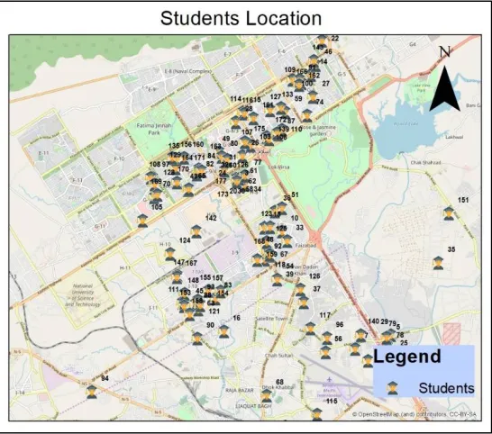
Virtual and online university systems have made achievements in recent years. However, there
93
are challenges in some countries because of the poor communication system, weak internet
94
infrastructure and sometimes lack of support from the political government [10]. A related
95
phenomenon that needs deliberation is the social presence which is of utmost importance in distance
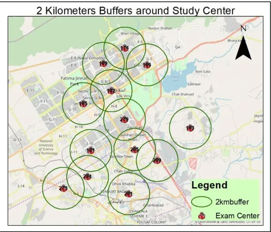
96
learning. The social presence enables distance leaner to be comfortable in interacting with peers and
97
instructors. Social presence is a prerequisite in online learning as it makes the leaner able to interact
98
and collaborate [11]. Social presence can be incorporated and increased by relying on new tools and
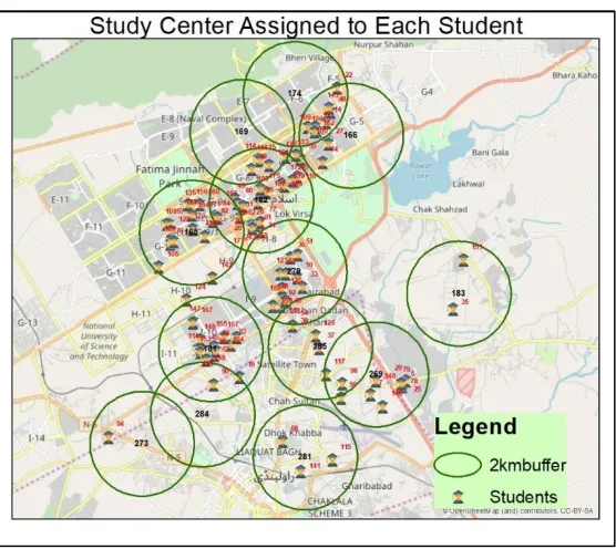
99
technologies in distance learning to make the leaners comfort level higher.
100
Viberg and Grönlund (2017) indicated the usage of tools and technologies by students to support
101
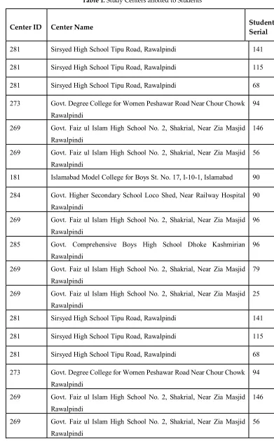
their learning because of flexibility, reliability, round the clock connectivity and its interactive nature
102
[12]. Students learn things as convenient to them because the information they want to access is
103
available to them round the clock without any issues and hurdles. Quick delivery is another major
104
concern in open and distance learning in case of Pakistan where the Government of Pakistan (GoP)
105
and Higher Education Commission (HEC) are continuously making efforts to make the overall
106
performance efficient [13]. The initiatives taken by the GoP and HEC are in the right direction
107
especially with new Digital Policy of Pakistan announced recently. However, there is a room for
108
improvement in this sector. AIOU provides some online web based services which is still not widely
109
accepted due to lack of awareness to access web based systems especially in the remote areas. On the
110
contrary, interactive systems and easy to use websites improve the overall effectiveness of online web
111
based service [14].
112
One of the major concerns in distance education from the cognitive perspective is the
113
transactional distance. This is defined as the cognitive space between the educator, distance learner
114
and the content of distance learning. Moore (1980) suggests that quality in distance learning is
115
improved when the educator and learner have cognitive proximity which can be achieved by
116
employing different strategies [15]. Reducing transactional distance can improve the learner’s
117
performance. The use of technology to reduce the transactional distance and increase learner’s
118
performance have been rated well in distance learning [16].
119
Kagwa and Kambyashi (1997) indicated the importance of using advanced database
120
learning delivery by maximizing interaction between the learner and the educator [17]. The usage of
122
technology based support system increases the interest of both learner and educator [18].
123
The literature discussed above analyzed and addressed different issues and problem faced by
124
students and educators in distance learning mode while delivering distance education. However,
125
there is a gap which exists in the literature which is not addressed. From learner’s perspective, the
126
inefficient allocation is the biggest problem which can be reduced if advanced technology is used for
127
allocation in Open and Distance Learning. Furthermore, the usage of geospatial technologies is
128
common in many areas such as agriculture [19], hydrology [20], land use planning [21] and natural
129
resource management [22]. However, no considerable studies are reported on the implementation of
130
geospatial technologies in open and distance learning to reduce the learners and educators’ problems
131
and issues. This research aims to present a real case study of AIOU and presents geospatial
132
technologies to solve a very realistic problem.
133
Geospatial technologies such as traditional GIS sometimes does not support the decision making
134
process sufficiently due to lack of analytical modeling capabilities [23]. This is due to the complex
135
nature of spatial problem which these technologies are unable to capture and the lack of flexibility in
136
these software’s. One of the solution to address the complexity of spatial problems in the
137
development of Spatial Decision Support System (SDSS). SDSS is an interactive computer based
138
system designed to support single or multiple users in decision making while solving a spatial
139
decision problem [24]. The complex nature of problems including multiple variables in open and
140
distance learning qualify the usage of SDSS in ODL. Thus potentials of SDSS can be exploited to
141
support decision making in allocation problems in open and distance learning which can be done in
142
future studies.
143
3. Materials and Methods
144
This section presents the material and methods. First of all data was acquired from Allama Iqbal
145
Open University. This data predominantly consisted of student’s addresses and study centers of
146
Islamabad and Rawalpindi cities. This data was preprocessed for further analysis. Spatial data
147
consisting addresses of students and study centers are then Geocoded2. Geocoding is the conversion
148
of text addresses to coordinates for proper visualization in processing in GIS. These addresses were
149
geocoded using Google Maps. This was the biggest challenge due to non-standard addresses system
150
in Pakistan. In Pakistan, every city has their own address schemes. One of the options we have
151
considered is that students may provide their geolocation’s while registering online when applying
152
for admissions in the university. This will reduce the burden of geocoding addresses manually and
153
saves a lot of time. The detailed methodology for the study is shown in Figure 1.
154
155
Figure 1. Detailed Flow Chart of Methodology
156
The geocoded addresses of students and study centers are visualized in ArcGIS3. It is assumed
157
that study centers should be within 2 kilometers distance of students. This will ensure students does
158
not face any difficulties while communicating with the tutors during the whole process of distance
159
learning. Several scenarios were run with different distance buffers and 2 kilometers was found to be
160
reasonable accessible distance. Rounded buffers of two kilometers are created around every study
161
centers and intersection operation was applied on the data which provides the number of students
162
and their details within the proximity of each buffer indicating the suitable study center for that
163
student. Finally the spatial algorithm for finding the nearest study center was performed which
164
provides a fair picture to decision makers on allocation of exam centers. Section 4 presents the results
165
and discussion.
166
3 ArcGIS is a proprietary GIS software developed and maintained by ESRI (Environmental Systems Research Institute),
http://www.esri.com
Data Collection (Students
and Study Centers)
Data Pre-Processing
(Geocoding
and Cleaning)
Spatial Mapping (Students
and Study Centers)
Spatial Analysis (Buffers
around Study Centers)
Spatial Analysis (Intersection
of Students and Zones)
4. Results and Discussion
167
Geocoded locations of data (students and study centers) from Rawalpindi and Islamabad were
168
mapped. In Geocoding the textual addresses are converted to geographical coordinates. In this study,
169
the geocoding was done by searching the text addresses and mapped after pointing the location out
170
in online mapping applications. The study centers of Rawalpindi and Islamabad can be seen in Figure
171
2. The data is overlaid on OpenStreetMap (OSM) data which gives a fair coverage of Volunteered
172
Geographic Information (VGI) in the twin cities. Each study center has a detailed attribute
173
information attached to this which can be seen on a single map click.
174
175
Figure 2. Study Centers (Rawalpindi/Islamabad)
176
177
178
Figure 3. Students Locations (Rawalpindi/Islamabad)
The next step was mapping of all students. For this purpose, Figure 3 shows the geographical
180
spread of students across the twin cities. The map concentration can be clearly can be seen and can
181
be used to get further insights such as hot spots analysis. Each student icon on map can be clicked or
182
searched to bring a detailed information for university management (see Figure 4).
183
184
Figure 4. Student Information
185
Two kilometers proximity is assumed as a feasible distance for students to ensure easy
186
interaction between the student and their tutors and study centers. The algorithm auto generated two
187
kilometers buffer around each study center. This indicates the students residing in those areas are
188
suitable to be allocated to that specific study center. This is demonstrated in Figure 5.
189
190
191
Figure 5. Two Kilometers Buffers around Study Centers
The next step was to assign the study center allocated to each student. The algorithm was run
193
on the available dataset. The results can be seen in Figure 6 where each student is assigned a tutor
194
based on distance proximity. For detailed analysis, a spatial query was formulated to see which exam
195
centers are assigned to which students. The web interface has been interactive which supports
196
likewise spatial queries that will assist management to conduct planning on map.
197
Table 1 shows that center 281 is allocated to students having identification numbers 141,115 and
198
68. This indicates that only three students are allocated to that center. There is also a complicated case
199
when one student is allocated to more than one exam center i.e. student serial number 96 has been
200
assigned to more than one study center (269 and 285).
201
A study center serial number 269 is located in Shakrial, Near Zia Masjid, Rawalpindi which is
202
in close proximity to study center serial number 285 which is located near Chour Chowk, Rawalpindi.
203
The distance between both the study centers is 2.85 kilometers while their distance from the
204
residential address of student number 96 is 1.63 kilometers and 1.8 kilometers respectively. This
205
brings the students within two kilometer proximity to both study centers. There is a filtering
206
mechanism in tier 2 of the algorithm which resolves this complexity.
207
208
209
210
Figure 6 Study Center allocation
211
213
Table 1. Study Centers allotted to Students
214
Center ID Center Name Student
Serial
281 Sirsyed High School Tipu Road, Rawalpindi 141
281 Sirsyed High School Tipu Road, Rawalpindi 115
281 Sirsyed High School Tipu Road, Rawalpindi 68
273 Govt. Degree College for Women Peshawar Road Near Chour Chowk
Rawalpindi
94
269 Govt. Faiz ul Islam High School No. 2, Shakrial, Near Zia Masjid
Rawalpindi
146
269 Govt. Faiz ul Islam High School No. 2, Shakrial, Near Zia Masjid
Rawalpindi
56
181 Islamabad Model College for Boys St. No. 17, I-10-1, Islamabad 90
284 Govt. Higher Secondary School Loco Shed, Near Railway Hospital
Rawalpindi
90
269 Govt. Faiz ul Islam High School No. 2, Shakrial, Near Zia Masjid
Rawalpindi
96
285 Govt. Comprehensive Boys High School Dhoke Kashmirian
Rawalpindi
96
269 Govt. Faiz ul Islam High School No. 2, Shakrial, Near Zia Masjid
Rawalpindi
79
269 Govt. Faiz ul Islam High School No. 2, Shakrial, Near Zia Masjid
Rawalpindi
25
281 Sirsyed High School Tipu Road, Rawalpindi 141
281 Sirsyed High School Tipu Road, Rawalpindi 115
281 Sirsyed High School Tipu Road, Rawalpindi 68
273 Govt. Degree College for Women Peshawar Road Near Chour Chowk
Rawalpindi
94
269 Govt. Faiz ul Islam High School No. 2, Shakrial, Near Zia Masjid
Rawalpindi
146
269 Govt. Faiz ul Islam High School No. 2, Shakrial, Near Zia Masjid
Rawalpindi
56
5. Conclusions
217
This study proves that geospatial technologies can be efficiently used to address allocation
218
problems in open and distance learning. Deploying simple yet effective techniques assist in
219
improving the overall operational capacity of distance education such as allocation. Assigning
220
distance educators and study centers based on geographical proximity will help reduce the physical
221
and cognitive distance between the learner and distance educator which is a dire need for improving
222
the performance of ODL education especially with the case of AIOU.
223
There are a few limitation associated with this study which needs to be addressed and improved.
224
For example, the proposed system in current study must be interoperable with existing system of
225
AIOU. Currently they are on slightly different architecture and our proposed technological stack can
226
easily be integrated. The geocoding in longer run needs to be automated. Currently there is no
227
standard addressing scheme which is followed across the country. However, a standard addressing
228
can be proposed where existing addresses can fit with the help of efficient algorithm. Another aspect
229
is related to assigning distance proximity. This can over allocate in case of urban areas where
230
population density is higher and under allocate in case of rural areas where the population density
231
is relatively smaller. This is left for future work.
232
Study centers allocation in this study only takes into account the geographical location of the
233
students and does not take into account other necessary details for allocation such as the course
234
details, gender of students, discipline enrolled and facilities available in the study center. Similalry,
235
work can be further expanded by including ‘Analytics’ in future studies. Online and distance leaners
236
create huge semi structured data which can be used to make informed decisions. Analytics plays a
237
vital role while designing new applications utilizing the data provided by users interacting with
238
different applications [25].
239
SDSS has the potential to address the issue of allocation in a more detailed manner as compared
240
to simple geospatial technologies. AIOU is the largest open and distance learning education in
241
Pakistan which can exploit the potentials of SDSS for tutors and study centers allocation considering
242
multiple factors and different alternatives. Online and distance learning education has a large user
243
base of potential users all over the world as fewer resources are needed to acquire skills. Online and
244
distance learning inflows are roughly $6 billion over the last five years [26]. This implies that systems
245
designed for solving allocations problems in online and distance learning has the potential to target
246
the industry and make an impact.
247
Although the study proved to be effective in solving the allocation problems in twin cities, in
248
future, we aim to make a completely independent and integrated web based software solution for
249
addressing allocation problems.
250
Acknowledgements: This study is financially support is provided by Higher Education
251
Commission (HEC), Pakistan under the National Research Program for Universities (NRPU). Data
252
for this study was provided by Allama Iqbal Open University (AIOU), Islamabad. The authors
253
grateful acknowledge their support.
254
Conflicts of Interest: The authors declare no conflict of interest.
References
257
1. Keegan, D. (1988). Concepts: Problems in defining the field of distance education. American Journal of
258
Distance Education, 2(2), 4-11
259
2. Dabbagh, N., & Bannan-Ritland, B. (2005). Online learning: Concepts, strategies, and application. Prentice
260
Hall.
261
3. Chang, K. T. (2006). Geographic information system. John Wiley & Sons, Ltd.
262
4. Mir, K. (2017). Design and Development of Online Student Support System. Pakistan Journal of Distance
263
and Online Learning, 3(1), 1-8.
264
5. Mir, K., & Kanwal, S. (2006). Spatial Decision Support System for Tutor and Study Centre allocation for
265
Distant Learning Institutes/System.
266
6. Beldarrain, Y. (2006). Distance education trends: Integrating new technologies to foster student interaction
267
and collaboration. Distance Education, 27(2), 139-153.
268
7. Dabbagh, N., & Bannan-Ritland, B. (2005). Online learning: Concepts, strategies, and application. Prentice
269
Hall.
270
8. O’Reilly, T. 2005. What is Web 2.0? Design patterns and business models for the next generation of software.
271
http://oreillynet.com/1pt/a/6228.
272
9. Chickering, A. W., & Ehrmann, S. C. (1996). Implementing the seven principles: Technology as
273
lever. AAHE Bulletin, 49, 3-6.
274
10. Darkwa, O., & Mazibuko, F. (2000). Creating virtual learning communities in Africa: Challenges and
275
prospects. First Monday, 5(5).
276
11. Ubon, N. A., & Kimble, C. (2004). Exploring social presence in asynchronous text-based online learning
277
communities (OLCS). In Proceedings of the 5th International Conference on Information Communication
278
Technologies in Education (pp. 292-297).
279
12. Viberg, O., & Grönlund, Å. (2017). Understanding students’ learning practices: challenges for design and
280
integration of mobile technology into distance education. Learning, Media, and Technology, 42(3), 357-377.
281
13. Arif, M., Ameen, K., & Rafiq, M. (2017). Assessing distance education students satisfaction with web-based
282
services: A Pakistani’s perspective. Online Information Review, 41(2), 202-218.
283
14. Wijayaratne, A., & Singh, D. (2010). Is there space in cyberspace for distance learners with special needs in
284
Asia? A review of the level of Web accessibility of institutional and library homepages of AAOU
285
members. The International Information & Library Review, 42(1), 40-49.
286
15. Moore, M. G. (1993). Theory of transactional distance. Theoretical principles of distance education, 1,
22-287
38.
288
16. Rabinovich, T., Berthon, P., & Fedorenko, I. (2017). Reducing the distance: financial services education in
289
web-extended learning environments. Journal of Financial Services Marketing, 22(3), 126-131.
290
17. Kagawa, O., & Kambayashi, Y. (1997). Advanced database functions for distance education system: VIEW
291
classroom. In Database Engineering and Applications Symposium, 1997. IDEAS'97. Proceedings.
292
International (pp. 231-239). IEEE.
293
18. Yoshino, T., Munemori, J., & Yuizono, T. (1999). Development and application of a distance learning
294
support system using personal computers via the Internet. In Parallel Processing (стр. 395-402). IEEE.
295
19. Bill, R., Nash, E., & Grenzdörffer, G. (2011). GIS in Agriculture. In Springer Handbook of geographic
296
information (pp. 461-476). Springer Berlin Heidelberg.
297
20. Clark, M. J. (1998). Putting water in its place: A perspective on GIS in hydrology and water management.
298
Hydrological Processes, 12(6), 823-834.
299
21. Ventura, S. J., Niemann, B. J., Sutphin, T. L., & Chenoweth, R. E. (2002). GIS-enhanced land-use planning.
300
Community Participation and Geographic Information Systems, 113-124.
301
22. McCall, M. K., & Minang, P. A. (2005). Assessing participatory GIS for community-based natural resource
302
management: claiming community forests in Cameroon. The Geographical Journal, 171(4), 340-356.
303
23. Densham, P. J. (1991). Spatial decision support systems. Geographical information systems: Principles and
304
Applications, 1, 403-412.
305
24. Malczewski, J. (1999). GIS and Multi-criteria decision analysis. New York: J. Wiley & Sons
306
25. Sangi, N. A., Mir, K., & Tahir, M. A. (2016). Using analytics to improve learner-centered application design.