www.ijper.org
Development of Geospatial Model for Preparing
Distribution of Rare Plant Resources Using
UAV/Drone
Takashi Watanabe1,2, Aedla Raju1,3,*, Yasuhide Hiraga1,4, Koji Sugimura1,2
1Department of Medicinal Plant, School of Pharmacy, Kumamoto University, 5-1 Oe-honmachi, Kumamoto 862-0973, Kumamoto, JAPAN.
2School of Pharmacy, Joint Research Laboratory of Agro-medicine for the Innovation of Agriculture, Kumamoto University, 5-1 Oe-honmachi, Kumamoto 862-0973, Kumamoto, JAPAN.
3Graduate School of Science and Technology (GSST), Kumamoto University, 2-39-1, Kurokami, Kumamoto, 860-8555, JAPAN. 4Hirata Corporation, 111 Hitotsugi, Ueki, Kita, Kumamoto, 861-0198, JAPAN.
ABSTRACT
Background: The study of functioning of ecosystems is significant with understanding the composition and distribution of plant resources at spatial and temporal scales. For comprehensive plant survey, the traditional methods are not accurate and it’s not possible at inaccessible areas. The remote sensing techniques with GIS and GPS are more helpful in acquiring the information in less time with more frequency at multiple altitudes. Objective: This study was proposed a remote sensing, image processing and GIS based an integrated geospatial model for identifying the rare plant resources using DJI Inspire 2 drone images. Methods: The drone images were pre-processed with band alignment, ortho-rectification and mosaicking and then enhanced using histogram equalization technique. The enhanced image was classified and analysed to generate the final distribution map. Results: The perfect zones of rare plant resources were identified from the enhanced image and the supervised classification has resulted accurate grouping of the plant resources. The weighted overlay analysis with soil data provided efficiently categorized the plant resources zones. Conclusion: The developed geospatial model was more efficient method for identification of plant resources. With additional developed remote sensing and image processing techniques, this model can provide automatic detection of plant resources based on spectral reflectance of the plants at different bands. To achieve this, the high resolution multi-spectral drone images are more appropriate. .
Key words: Rare plant resource, Remote sensing, GIS, GPS, UAV, Drone and geospatial model.
DOI: 10.5530/ijper.52.4s.91
Correspondence:
Dr. Aedla Raju,
Research Scientist, Depart-ment of Medicinal Plant, School of Pharmacy, Kuma-moto University, 5-1 Oe-hon-machi, Kumamoto 862-0973, Kumamoto, JAPAN Phone: : +81-96-371-4781 E-mail: rajuaedla.nitk@gmail. com
INTRODUCTION
The distribution of plant resources at various spatial and temporal scales normalizes the functioning of ecosystems. It is important to study the composition and distribution of plant resources for regulating the func-tionality of ecosystem, which standardises the global climate change and other envi-ronmental issues. Traditional methods over large and inaccessible areas are more time consuming, expensive and required massive manpower.1 In sensitive ecosystems, intensive
Submission Date: 30-08-2017; Revision Date: 17-11-2017; Accepted Date: 23-11-2017
plant surveys are also not adequate due to soil compaction, disruption of soil organic layers, trampling, and vegetation damage.2
delivers data for continuous monitoring to iden-tify the variations in the plant resources.3 The
information (data) will be collected at various resolutions based on the plant cat-egory and species type. Sometimes high reso-lution remote sensing images are not enough to identify and plot the exact species. Identification and preparation of distribution of plant resources useful in understanding the functioning of the ecosystems also to perceive new plants species which are more useful for food and medical purposes. Compared to remote sensing satellite images, UAV/Drone images have a much greater resolution and better flexibility in collecting the plants data at suitable time and space resolution.4,5 High
spatial resolution with multi-spectral band images are more appropriate in identifying the individual species and to understand the various physical characteristics of the plants. In some plant investigations, it is highly difficult to identify the small and similar species by sepa-rating from the neighbour species. The advanced image processing techniques are more expedient and results efficient detection of plants. With the importance of image processing techniques in UAV/Drone images for plant research, the present study proposed a geospatial model for identification and distribution of rare plant resources using UAV/Drone images.
The present paper is organized into four sections. The first section introduced the concept and significance of the study. Section 2 describes the various data products used for the study and the proposed methodology of geospatial model. Section 3 discuss the results obtained from the analysis and, section 4 outlined with concluding remarks and recommendations.
DATA PRODUCTS AND METHODOLOGY UAV / Drone Description
DJI Inspire 2, model T650 was used to collect a set of aerial images at different altitudes at Milky Road, Aso, Kumamoto, Japan, considered as a study area. Parrot Sequoia Multispectral Sensor was fixed with the drone, which captured the plants across the four highly defined, visible and non-visible spectral bands, plus RGB imagery. Parrot Sequoia is one of the smallest and light weighted multispectral UAS sensor, which has two sensors, one is multi-spectral sensor with 4 bands (Green, Red, Red Edge and Near Infrared) and another one is sunshine sensor.
Geospatial Model
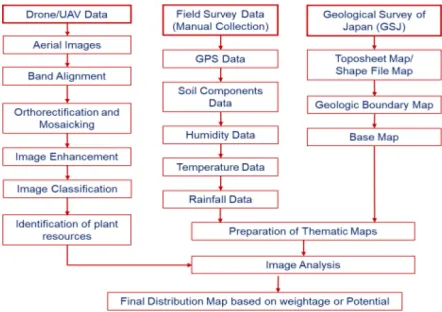
The geospatial model was developed for detection and preparation of rare plant resources distribution using
UAV/Drone images as shown in Figure 1. The aerial images acquired by the Drone were first pre-processed with band alignment of multi-spectral imagery, ortho-rectification and mosaicking. The band alignment was executed on the multi-spectral images to match and compile the 4 bands into a single comprehensive file. The final readable file was transformed into a unique multi-band image file. For the suitable processing, the multi-band image was converted into a TIFF-readable image format using ENVI 5.1 software. The complete study area was collected in a sequence of aerial images during each flight. Now all individual images were combined and overlapped using orthorectification and mosaicking process. All the images were processed through the software and based on geographical coor-dinates all individual images were set into a single image, which covered entire area of the study. The pre- processed image was further processed through image enhancement, classification and then analysed for identification of plant resources. Based on the image resolution and quality, the images were enhanced using contrast enhancement, mainly Histogram Equalization.6,7
After achieving the proper enhancement, the image was classified using supervised classification technique using ERDAS Imagine software. The classified image was further analysed along with filed data like soil data (pH, hardness, moisture, organic matter etc.). Then, the classified plant resources, filed data (attribute data) and topography maps were analysed using weighted overlay analysis technique to generate the final distribution map based on filed data and plant pixel intensity.
RESULTS AND DISCUSSION
The multi-spectral images were more worthwhile in identification of several kinds of plant resources in the study area. Each spectral band provides specific infor-mation of the plant. The spectral reflectance values of
the plants in each band delivers very significant infor-mation of plants like chlorophyll content, health and disease of the plants etc. The band alignment provided best orientation of individual bands into single readable file. The individual multi-spectral (Green, Red, Red Edge and Near Infrared) images of Drone are shown in Figure 2. Orthorectification and mosaicking methods were geometrically georeferenced the images and combined the individual continuous images into a single image. Based on the spectral reflectance values of the plants, the Green-band image was considered for
iden-tification of distribution of plant resources in the study area. The histogram of the green-band image is shown in Figure 3.
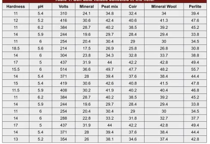
The Green-band image was enhanced using histogram equalization, a well-known contrast enhancement tech-nique, which highlighted the plant features by supressing other features in the image. The histogram equalized image is shown in Figure 4. The enhanced image was indicated the desired plant resources in the area and these resources were extracted using supervised classification technique. The identified plant resources were shown in Figure 5. The soil data values are as shown in Tab1e 1, which were considered for analysis. A GIS based, weightage overlay analysis technique was performed with plant resources and soil data. The final distribution map was categorized the plant resources into excellent, good, moderate good and poor as shown in Figure 6. The excellent zones are more suitable plant resources with good soil conditions. The excellent zones have high Figure 2: The multi-spectral (Green, Red, Red Edge and Near
Infrared) and RGB images.
Figure 3: Histogram of Green Band Image
Figure 4: Histogram Equalized Image of Green band Image.
Figure 5: Identified plant resources map.
Table 1: Soil data values collected in the field.
Hardness pH Volts Mineral Peat mix Coir Mineral Wool Perlite
11 5.4 310 24.1 34.8 32.4 34 39.4
12 5.2 416 30.6 42.4 40.6 41.3 47.6
11 6.2 384 28.7 40.2 38.5 39.2 45.2
14 5.9 244 19.6 29.7 28.4 29.4 33.8
11 6 254 20.4 30.4 29 30 34.5
18.5 5.6 214 17.5 26.9 25.8 26.8 30.8
14 6 304 23.8 34.3 32.8 33.7 38.8
17 5 437 31.9 44 42.2 42.8 49.4
15.5 6 514 36.6 49.7 47.7 48.2 55.7
14 5.4 371 28 39.4 37.6 38.4 44.4
15 5.4 419 30.6 42.6 40.8 41.5 47.8
11.5 5.9 408 30.2 41.9 40.2 40.4 46.8
11 6.2 384 28.7 40.2 38.5 39.2 45.2
14 5.9 244 19.6 29.7 28.4 29.4 33.8
11 6 254 20.4 30.4 29 30 34.5
14 6 288 22.8 33.2 31.8 32.7 37.7
17 5 437 31.9 44 42.2 42.8 49.4
14 5.4 371 28 39.4 37.6 38.4 44.4
13 5.2 354 26 38.1 34.6 37.4 42.8
number of elements, which helps the plant existence. Similar conditions were created for the development of hotspots for cultivation of plants.
CONCLUSION
The remote sensing, GIS and GPS techniques are more appropriate methods for identification various rare plant resources and preparation of plant distribution. The field survey data benefits in efficient distribution of plant resources. The developed geospatial method was very convenient and well-organized method for identification and preparation of plant distribution. In the case of inaccessible areas, this geospatial method is more useful in identification of plant resources in a very competent manner. Drone images are more constructive in plant investigation. The multispectral images are providing various information, which is essential in accurate analysis of plant resources. Very clear images of the drone bring better accuracy in identification of plant resources. Additional number of field data sample values will advantage in well analysis of data, which results a proper and exact plant investigation.
ACKNOWLEDGMENT
The authors are grateful to School of Pharmacy, Kuma-moto University, KumaKuma-moto, Japan for the support to carry out this research work.
CONFLICT OF INTEREST
The authors declare no conflcit of interest
ABBREVIATIONS
GIS: Geographical Information System; RS: Remote
Sensing; GPS: Global Positioning System; UAV:
Unmanned Aerial Vehicles; UAS: Unmanned Aircraft
System; GSJ: Geological Survey of Japan.
REFERENCES
1. Aedla R, Dwarakish GS, Reddy VD. Automatic Shoreline Detection and Change Detection Analysis of Netravati-Gurpur Rivermouth Using Histogram Equalization and Adaptive Thresholding Techniques. Aquatic Procedia. 2015;4:563-70.
2. Mitchell BC, Ben GW, Monica RG, Brendan FK, Elizabeth CH, Tina MA, et al. Small Unmanned Aerial Vehicles (Micro-UAVs, Drones) in Plant Ecology. Applications in Plant Sciences. 2016;4(9):1-11.
3. Dvorak P, Mullerova J, Bartalos T, Bruna J. Unmanned Aerial Vehicles for Alien Plan Species Detection and Monitoring. The International Archives of the Photpogrammetry. Remote Sensing and Spatial Information Sciences. 2015;40(1):83.
4. Esther S, Cristina B, Enric P. UAV Flight Experiments Applied to the Remote Sensing of Vegetated Areas. Remote Sensing. 2014;6(11):11051-81. 5. Zhnag C, Kovacs JM. The Application of Small Unmanned Aerial Systems for
Precision Agriculture: A Review. Precision Agriculture. 2012;13(6):693-712. 6. Raju A, Dwarakish GS, Reddy VD. A State-of-the-Art and Comparative
Analysis of Mean Brightness Preserving Histogram Equalization based Contrast Enhancement Techniques. International Journal of Remote Sensing and GIS. 2013;2(1):41-51.
Cite this article: Watanabe T, Raju A, Hiraga Y, Sugimura K. Development of Geospatial Model for Preparing Distribution of Rare Plant Resources Using UAV/Drone. Indian J of Pharmaceutical Education and Research. 2018;52(4S):S146-S150.
PICTORIAL ABSTRACT SUMMARY
• The present study was proposed a GIS, RS and GPS based geospatial model for preparing the dis-tribution map of rare plant resources.
• The multispectral drone images were used to iden-tify the distribution area of the plants.
• The GPS location, pH, hardness and soil moisture values were recorded during the field investiga-tion.
• By using the image processing techniques and weighted overlay analysis spatial method, the final distribution map was prepared by categoriz-ing into excellent, good, moderate good and poor zones based on significance of the data.
Dr. Takashi Watanabe is a Professor, Eco-Frontier Center Chief of Medicinal Resources, Department of Medicinal Plant, Eco-Frontier Center of Medicinal Resources, Graduate School of Pharmaceutical Sciences, Kumamoto University, Kumamoto, Japan. His field of specialization is an evaluation of natural medicinal resources using both chemical and molecular analysis, Biotechnology, Plant inventory, Ecological study and sustainable use of the medicinal plant resources and developmental assistance for herbal product.
Dr. Raju Aedla, is a Research Scientist, Kumamoto University, Kumamoto, Japan. He has published 37 technical papers in reputed international journals and conference proceedings. His current research interests are Digital Image Processing, Remote Sensing, GIS and Satellite/Drone Image Analysis in Plant Applications.
About Authors
Mr. Yasuhide Hiraga has been the Chief Technical Officer of Hirata Corporation, Japan since April 2015 and its serves as Division Director of Research & Development Headquarters. He has been Vice President of Hirata Corporation since March 31, 2009 and served as its Director of Development Div. and New Business Development since January 21, 2016 until February 11, 2016.