University of Zurich Main Library Strickhofstrasse 39 CH-8057 Zurich www.zora.uzh.ch Year: 2015
Relating movement to geographic context: effects of preprocessing, relation methods and scale
Gschwend, Christian
Abstract: Movement (in space and time) is studied by different research fields, such as GIScience, move-ment ecology, or urban planning in order to gain insights into behavior of animals or people. Recent technological advancements allow collecting huge volumes of movement data in the form of GPS records. Movement analysis aims at developing methods with a strong focus on detecting movement patterns in relation to movement behavior. In this context, data mining as the key process of knowledge discovery in databases (KDD) is often applied on movement data in order to achieve a better understanding of move-ment patterns in terms of the moving objects’ behavior. Within spatial data mining, movemove-ment patterns today are mostly quantified on the basis of geometric properties and the arrangement of the GPS points. Although information about the geographic environment surrounding the movement patterns could pro-vide semantics, from a methodological point of view, thus far the relation of movement to its surrounding geographic context has largely been neglected. Therefore, in this thesis, the relation of movement to the geographic context is investigated with regard to effects of preprocessing, its sensitivity to different methods for relating the movement to its embedding geographic context, and scale issues. Preprocessing primarily aims at removing erroneous and filtering irrelevant data. In the KDD process, the focus lies on data mining, and the therewith development of algorithms. Besides data mining, preprocessing is also well established in recent research on movement analysis, as for example with the detection of stops and moves, or the identification of inaccurate GPS measurements. However, preprocessing is specific to almost each study, depending on various factors, such as, for example, the species under investigation or the problem scenario. Nevertheless, a common ground for preprocessing in movement analysis can be formalized on a more general level. In this work, a preprocessing workflow based on averaged speed values is presented. This preprocessing workflow proved to enable the detection of stops and moves at different temporal scales, applicable within different research contexts. Further, effects of preprocessing on the computation of movement parameters and their relation to geographic context were investigated in different case studies. The various experiments on quantitative effects of preprocessing procedures produced a complex picture. While in some cases the effect of preprocessing was significant (e.g., com-puting speed values on map-matched movement data), in others it was negligible (e.g., filtering stops in movement data with low temporal sampling rate). The experiments illustrated that preprocessing of movement data can cause expected (e.g., low speed values at stops), but also unexpected effects (e.g., unrealistic speed values due to map matching). All in all, on a more specific level, it is not possible to establish generic guidelines; instead, besides the presented preprocessing workflow, individual considera-tions are required on a case-by-case basis. GPS data are usually captured as a temporal sequence of point locations. Although a variety of movement models from different disciplines (e.g., GIScience, movement ecology) exist, in GIScience, movement most often is modeled in the form of points. As a consequence, movement-context relation methods are commonly based on the point geometry of the movement data with the use of some form of buffer analysis. In this work, we present a movement-context relation matrix, where different movement-context relation methods are categorized on the basis of models for movement (x-axis) and context (y-axis). The matrix was validated with a case study relating the movement of
relation of movement to geographic context different types of scale, such as the temporal scale of the movement, as well as the spatial and thematic scale of the context come into play. Recent studies in movement analysis most often focused on effects of varying the temporal scale. When even different sorts of scale are considered, interdependencies between different scales have rarely been investigated thus far. Therefore, sensitivity experiments were conducted with regard to different types of scale (temporal scale of movement, and spatial and thematic scale of geographic context). Besides effects of spatial and thematic scale of the geographic context on the result of relating movement to geographic context, interdependen-cies between all the types of scale under investigation in this thesis, were revealed. As a consequence, different types of scale cannot be regarded in isolation with regard to the relation of movement and geo-graphic context. This thesis confirmed that taking into account different types of scale is crucial in order to understand movement in relation to its surrounding geographic environment. Coefficient of variation analysis allowed gaining the insight that within the relation of movement and geographic context, effects of scale and variations caused by different relation methods can be in the same order of magnitude. In a first case study – relating animal movement (and its properties) to land cover and terrain using different relation methods – revealed manifold and not easy-to- predict dependencies between problem scenario, data granularity, chosen relation method and relation method parameterizations. Similarly, in a second case study – relating the movement of outdoor sportsmen and urban shoppers to their movement context – also revealed that in some constellations, the choice of relation method and the method for deriving context variables has significant impact on the strength of relations found. For instance, it was shown that correlation analysis is highly sensitive to different quantitative methods for modeling slope. This study illustrated the substantial difficulty to distinguish between what is really a new insight in terms of movement behavior and what appears to be an artifact of the methodology. In the course of this work, different factors that play an important role in the relation of movement to geographic context were revealed. On the one hand, the quantification of aspects of movement and the geographic context proved to be crucial when relating them. On the other hand, preprocessing, movement-context relation methods, and scale showed having a significant impact on quantifying the relation of movement to geo-graphic context. The insights gained in this thesis can support future studies with methods for developing more specific tools for context-aware movement analysis. This thesis presented means for bridging the semantic gap between movement patterns and movement behavior through the relation of movement to geographic context. Revealing causal relationships between movement and geographic context, however, still remains a major challenge of future research. In relation to statements of Dodge et al. (2008, p.245, according to Blythe et al., 1996) and Orellana Renso (2010, p.67), this dissertation allows the following conclusion: “Movement is behavior, but patterns are not yet.” Zusammenfassung Bewegung (in Raum und Zeit) ist Gegenstand verschiedener Forschungsfelder, wie etwa der Geographischen Informationswis-senschaft, der Bewegungsökologie oder der Stadtplanung. Bewegungsanalyse vermag Erkenntnisse über das Verhalten von Tieren und Menschen aufzudecken. Heute verfügbare Technologien erlauben das Sammeln grosser Mengen von Bewegungsdaten in Form von GPS-Aufnahmen. Die methodische Diszi-plin der Bewegungsanalyse beabsichtigt das Auffinden von Bewegungsmustern hinsichtlich eines besseren Verständnisses von Bewegungsverhalten. In diesem Zusammenhang wird häufig Data-Mining als Teil-prozess des Knowledge Discovery in Databases (KDD) auf Bewegungsdaten angewendet. Innerhalb des räumlichen Data-Mining werden Bewegungsmuster heutzutage meis- tens auf der Basis geometrischer Eigenschaften und der Anordnung von GPS-Punkten quantifiziert. Obwohl Informationen über die ge-ographische Umgebung zur semanti- schen Anreicherung von Bewegungsmustern dienen könnten, wurden bisher Methoden zur expliziten Quantifizierung des Zusammenhangs zwischen der Bewegung und dem geographischen Kontext weitgehend vernachlässigt. Deshalb wird in dieser Arbeit die Verknüpfung der Bewegung und dem geographischem Kontext in Bezug auf Effekte der Vorverarbeitung, dessen Sensitiv-ität gegenüber Methoden zur Verknüpfung der Bewegung mit geographischem Kontext und Skalenaspekte untersucht. Die Vorverarbeitung dient primär dem Entfernen fehlerhafter und dem Filtern irrelevanter Daten. Im KDD-Prozess liegt der Fokus auf dem Data-Mining und der damit verbundenen Entwicklung von Algorithmen. Nebst Data-Mining ist die Vorverarbei- tung ein anerkannter Bestandteil des KDD-Prozesses innerhalb kürzlich erschienener Forschungsarbeiten der Bewegungsanalyse, wie zum Beispiel beim Detektieren von Stopps und Bewegungsphasen oder der Identifikation ungenauer GPS-Messungen. Es zeigt sich allerdings, dass die Vorverarbeitung für beinahe jede Studie in Abhängigkeit spezifischer Rahmenbedingungen (z.B. Art des Bewegungsobjekts oder Problemszenario) unterschiedlich ausgestaltet werden muss. Dennoch kann eine gemeinsame Basis für unterschiedliche Studien hinsichtlich der Vorverar-beitung in der Bewegungsanalyse auf einem allgemeineren Level formuliert werden. In dieser Arbeit wird ein Vorverarbeitungs-Arbeitsablauf, welcher auf gemittelten Geschwindigkeitswerten basiert, präsentiert. Dieser Vorverarbeitungsprozess hat sich für die Detektion von Stopps und Bewegungsphasen verschiedener zeitlicher Skalen innerhalb verschiedener Forschungskontexte als geeignet erwiesen. Des Weiteren
wur-Effekte waren in einigen Fällen signifikant (z.B. Berechnung der Geschwindigkeit auf mit Map-Matching korrigierte Bewegungsdaten), in einigen anderen vernachlässigbar (z.B. Filtern von Stopps in Bewegungs-daten mit tiefer zeitlicher Auflösung). Die Experimente illustrierten, dass die Vorverarbeitung der Be-wegungsdaten erwartete (z.B. tiefe Geschwindigkeiten bei Stoppphasen), aber auch unerwartete Effekte (z.B. unrealistische Geschwindigkeitswerte aufgrund des Map-Matching) zur Folge haben kann. Alles in allem gibt es diesbezüglich keine generellen Richtlinien; stattdessen benötigt man nebst einem all-gemeineren Vorverarbeitungs-Arbeitsablauf auch spezifische Annahmen von Fall zu Fall. GPS-Daten werden normalerweise als Beobachtungspunkte in zeitlicher Abfolge erfasst. Obwohl eine grosse Vielfalt an Bewegungsmodellen aus verschiedenen Disziplinen (z.B. Geographische Informationswissenschaft, Be-wegungsökologie) existieren, wird die Bewegung in der Geographischen Informationswissenschaft oft in Form von Punkten modelliert. Demzufolge basieren auch Bewegung-Kontext-Verknüpfungsmethoden normalerweise auf Punktgeometrien der Bewegungsdaten, wie beispielsweise mit der Anwendung einer Pufferanalyse. In dieser Arbeit präsentieren wir eine Bewegung-Kontext-Verknüpfungsmatrix, bei welcher Bewegung-Kontext-Verknüpfungsmethoden auf der Basis von Bewegungs- (x-Achse) und Kontextmod-ellen (y-Achse) strukturiert werden. Die Matrix wurde mit einer Fallstudie validiert, indem Tierbewegun-gen in Bezug zu Faktoren des umgebenden geographischen Kontexts gesetzt wurde. Verschiedene Vari-anten zur Modellierung der Bewegung und die damit verbundene Anwendung verschiedener Bewegung-Kontext-Verknüpfungsmethoden resultierten in signifikanten Differenzen in den Verteilungen der Raum-nutzung generiert in Bezug auf den geographischen Kontext. Deshalb stellt die vorgeschlagene Bewegung- Verknüpfungsmatrix ein sinnvolles Mittel zur Auswahl einer geeigneten Bewegung- Bewegung- Kontext-Verknüpfungsmethode dar. Bei der Verknüpfung der Bewegung und des geographischen Kontexts kom-men verschiedene Skalenarten, wie die zeitliche Skala der Bewegung und die räumliche und thematische Skala des Kontexts ins Spiel. Neuste Studien der Bewegungsanalyse tragen häufig nur der zeitlichen Skala der Bewegung Rechnung. Falls sogar verschiedene Skalensorten berücksichtigt werden, werden jedoch Abhängigkeiten zwischen den Skalen bisher selten untersucht. Deshalb wurden in dieser Disserta-tion Sensitivitätsexperimente hinsichtlich verschiedener Skalentypen (zeitliche Skala der Bewegung, und räumliche und thematische Skala des geographischen Kontexts) durchgeführt. Nebst Effekten räumlicher und thematischer Skala des geographischen Kontexts auf das Resultat der Verknüpfung der Bewegung und geographischem Kontext, wurden Abhängigkeiten zwischen allen in dieser Arbeit untersuchten Ska-lentypen aufgezeigt. Deshalb können verschiedene Skalenarten in Bezug auf die Verknüpfung von Bewe-gung und geographischem Kontext nicht isoliert betrachtet werden. Diese Arbeit bestätigte, dass die Berücksichtigung verschiedener Instanzen verschiedener Skalenarten für das Verständnis der Bewegung in Bezug auf dessen geographische Umwelt wesentlich ist. Die Analyse mittels Variationskoeffizienten hat die Erkenntnis erlaubt, dass Effekte in der Bewegung-Kontext-Verknüpfung aufgrund der Skalenvariation und unterschiedlicher Verknüpfungsmethoden in der gleichen Grössenordnung liegen können. In einer er-sten Fallstudie hat die Verknüpfung von Tierbewegungen (und deren Eigenschaften) zu Bodenbedeckung und Gelände mit verschiedenen Verknüpfungsmethoden, vielfältige und nicht einfach vorherzusagende Ab-hängigkeiten zwischen Problemszenario, Datengranularität, gewählter Verknüpfungsmethode und Meth-odenparametrisierung aufgedeckt. Ebenso zeigte die Verknüpfung der Bewegung von Outdoor-Sportlern und städtischen Einkäufern zu deren Bewegungskontext in einer zweiten Fallstudie, dass in einigen Kon-stellationen die Wahl der Verknüpfungsmethode und die Methode zum Ableiten von Kontextvariablen einen signifikanten Einfluss auf die gefundene Zusammenhangsstärke haben. Es wurde zum Beispiel gezeigt, dass die Korrelationsanalyse hoch sensitiv gegenüber verschiedener quantitativer Methoden für die Modellierung der Hangneigung ist. Diese Studie illustrierte die beachtliche Schwierigkeit der Unter-scheidung zwischen neuen Erkenntnissen in Bezug auf Bewegungsverhalten und Artefakten der Methodik. Im Zuge dieser Arbeit wurde aufgedeckt, dass verschiedene Faktoren in der Verknüpfung der Bewe-gung und des geographischen Kontexts eine wichtige Rolle spielen. Einerseits hat sich die Methodik zur Quantifizierung von Aspekten der Bewegung und des geographischen Kontexts bei deren Verknüp-fung als entscheidend erwiesen. Andererseits hat diese Arbeit aufgezeigt, dass die Vorverarbeitung, Bewegung-Kontext-Verknüpfungsmethoden und Skala, massgebliche Einflussfaktoren auf die quantita-tive Ausprägung des Zusammenhangs zwischen der Bewegung und dessen geographischen Kontext sind. Die Erkenntnisse, welche in dieser Dissertation gewonnen werden konnten, können in zukünftigen Studien zur Entwicklung spezifischer Werkzeuge für die kontext-sensitive Bewegungsanalyse beitragen. In dieser Arbeit wurden Mittel zur Überbrückung der semantischen Lücke zwischen Bewegungsmustern und Be-wegungsverhalten durch die Verknüpfung der Bewegung und geographischem Kontext präsentiert. Das Enthüllen kausaler Zusammenhänge zwischen Bewegung und geographischem Kontext bleibt dennoch eine Hauptherausforderung zukünftiger Forschung. Diese Erkenntnisse erlauben die folgende Schlussfol-gerung in Anlehnung an die Aussagen von Dodge et al. (2008, p.245, according to Blythe et al., 1996)
ZORA URL: https://doi.org/10.5167/uzh-135565 Dissertation
Published Version Originally published at:
Gschwend, Christian. Relating movement to geographic context: effects of preprocessing, relation meth-ods and scale. 2015, University of Zurich, Faculty of Science.
Dissertation
zur
Erlangung der naturwissenschaftlichen Doktorwürde (Dr. sc. nat.) vorgelegt der Mathematisch-naturwissenschaftlichen Fakultät der Universität Zürich von Christian Gschwend von Altstätten SG Promotionskomitee
Prof. Dr. Robert Weibel (Vorsitz) Prof. Dr. Ross Purves Prof. Dr. Nico Van de Weghe
PD Dr. Patrick Laube (Leitung der Dissertation)
Movement (in space and time) is studied by different research fields, such as GIScience, movement ecology, or urban planning in order to gain insights into behavior of animals or people. Recent technological advancements allow collecting huge volumes of movement data in the form of GPS records. Movement analysis aims at developing methods with a strong focus on detecting movement patterns in relation to movement behavior. In this context, data mining as the key process of knowledge discovery in databases (KDD) is often applied on movement data in order to achieve a better understanding of movement patterns in terms of the moving objects’ behavior.
Within spatial data mining, movement patterns today are mostly quantified on the basis of geometric properties and the arrangement of the GPS points. Although information about the geographic environment surrounding the movement patterns could provide semantics, from a methodological point of view, thus far the relation of movement to its surrounding geographic context has largely been neglected. Therefore, in this thesis, the relation of movement to the geographic context is investigated with regard to effects of preprocessing, its sensitivity to different methods for relating the movement to its embedding geographic context, and scale issues.
Preprocessing primarily aims at removing erroneous and filtering irrelevant data. In the KDD process, the focus lies on data mining, and the therewith development of algorithms. Besides data mining, preprocessing is also well established in recent research on movement analysis, as for example with the detection of stops and moves, or the identification of inaccurate GPS measurements. However, preprocessing is specific to almost each study, depending on various factors, such as, for example, the species under investigation or the problem scenario. Nevertheless, a common ground for preprocessing in movement analysis can be formalized on a more general level. In this work, a preprocessing workflow based on averaged speed values is presented. This preprocessing workflow proved to enable the detection of stops and moves at different temporal scales, applicable within different research contexts. Further, effects of preprocessing on the computation of movement parameters and their relation to geographic context were investigated in different case studies. The various experiments on quantitative effects of preprocessing procedures produced a complex picture. While in some cases the effect of preprocessing was significant (e.g., computing speed values on map-matched movement data), in others it was negligible (e.g., filtering stops in movement data with low temporal sampling rate). The experiments illustrated that preprocessing of movement data can cause expected (e.g., low speed values at stops), but also unexpected effects (e.g., unrealistic speed values due to map matching). All in all, on a more specific level, it is not possible to establish generic guidelines; instead,
on a case-by-case basis.
GPS data are usually captured as a temporal sequence of point locations. Although a variety of movement models from different disciplines (e.g., GIScience, movement ecology) exist, in GIScience, movement most often is modeled in the form of points. As a consequence, movement-context relation methods are commonly based on the point geometry of the movement data with the use of some form of buffer analysis. In this work, we present a context relation matrix, where different movement-context relation methods are categorized on the basis of models for movement (x-axis) and context (y-axis). The matrix was validated with a case study relating the movement of animals to factors of their geographic context. Different movement models and the therewith application of different movement-context relation methods resulted in significant differences in the space-use distributions generated with regard to the geographic context. Therefore, the proposed movement-context relation matrix is a reasonable means for choosing a suitable movement-context relation method.
In the relation of movement to geographic context different types of scale, such as the temporal scale of the movement, as well as the spatial and thematic scale of the context come into play. Recent studies in movement analysis most often focused on effects of varying the temporal scale. When even different sorts of scale are considered, interdependencies between different scales have rarely been investigated thus far. Therefore, sensitivity experiments were conducted with regard to different types of scale (temporal scale of movement, and spatial and thematic scale of geographic context). Besides effects of spatial and thematic scale of the geographic context on the result of relating movement to geographic context, interdependencies between all the types of scale under investigation in this thesis, were revealed. As a consequence, different types of scale cannot be regarded in isolation with regard to the relation of movement and geographic context. This thesis confirmed that taking into account different types of scale is crucial in order to understand movement in relation to its surrounding geographic environment. Coefficient of variation analysis allowed gaining the insight that within the relation of movement and geographic context, effects of scale and variations caused by different relation methods can be in the same order of magnitude.
In a first case study – relating animal movement (and its properties) to land cover and terrain using different relation methods – revealed manifold and not easy-to-predict dependencies between problem scenario, data granularity, chosen relation method and relation method parameterizations. Similarly, in a second case study – relating the movement of outdoor sportsmen and urban shoppers to their movement context – also revealed that in some constellations, the choice of relation method and the method for deriving context variables has significant impact on the strength of relations found. For instance, it was shown that correlation analysis is highly sensitive to different quantitative methods for modeling slope. This study illustrated the substantial difficulty to distinguish between what is really a new insight in terms of movement behavior and what appears to be an artifact of the methodology.
quantification of aspects of movement and the geographic context proved to be crucial when relating them. On the other hand, preprocessing, movement-context relation methods, and scale showed having a significant impact on quantifying the relation of movement to geographic context. The insights gained in this thesis can support future studies with methods for developing more specific tools for context-aware movement analysis. This thesis presented means for bridging the semantic gap between movement patterns and movement behavior through the relation of movement to geographic context. Revealing causal relationships between movement and geographic context, however, still remains a major challenge of future research. In relation to statements of Dodgeet al. (2008, p.245, according toBlythe et al., 1996) and Orellana&
Renso (2010, p.67), this dissertation allows the following conclusion: “Movement is behavior, but patterns are not yet.”
Bewegung (in Raum und Zeit) ist Gegenstand verschiedener Forschungsfelder, wie etwa der Geographischen Informationswissenschaft, der Bewegungsökologie oder der Stadtplanung. Bewegungsanalyse vermag Erkenntnisse über das Verhalten von Tieren und Menschen aufzudecken. Heute verfügbare Technologien erlauben das Sammeln grosser Mengen von Bewegungsdaten in Form von GPS-Aufnahmen. Die methodische Disziplin der Bewegungsanalyse beabsichtigt das Auffinden von Bewegungsmustern hinsichtlich eines besseren Verständnisses von Bewegungsverhalten. In diesem Zu-sammenhang wird häufig Data-Mining als Teilprozess des Knowledge Discovery in Databases (KDD) auf Bewegungsdaten angewendet.
Innerhalb des räumlichen Data-Mining werden Bewegungsmuster heutzutage meis-tens auf der Basis geometrischer Eigenschaften und der Anordnung von GPS-Punkten quantifiziert. Obwohl Informationen über die geographische Umgebung zur semanti-schen Anreicherung von Bewegungsmustern dienen könnten, wurden bisher Methoden zur expliziten Quantifizierung des Zusammenhangs zwischen der Bewegung und dem geographischen Kontext weitgehend vernachlässigt. Deshalb wird in dieser Arbeit die Verknüpfung der Bewegung und dem geographischem Kontext in Bezug auf Effekte der Vorverarbeitung, dessen Sensitivität gegenüber Methoden zur Verknüpfung der Bewegung mit geographischem Kontext und Skalenaspekte untersucht.
Die Vorverarbeitung dient primär dem Entfernen fehlerhafter und dem Filtern irre-levanter Daten. Im KDD-Prozess liegt der Fokus auf dem Data-Mining und der damit verbundenen Entwicklung von Algorithmen. Nebst Data-Mining ist die Vorverarbei-tung ein anerkannter Bestandteil des KDD-Prozesses innerhalb kürzlich erschienener Forschungsarbeiten der Bewegungsanalyse, wie zum Beispiel beim Detektieren von Stopps und Bewegungsphasen oder der Identifikation ungenauer GPS-Messungen. Es zeigt sich allerdings, dass die Vorverarbeitung für beinahe jede Studie in Ab-hängigkeit spezifischer Rahmenbedingungen (z.B. Art des Bewegungsobjekts oder Problemszenario) unterschiedlich ausgestaltet werden muss. Dennoch kann eine ge-meinsame Basis für unterschiedliche Studien hinsichtlich der Vorverarbeitung in der Bewegungsanalyse auf einem allgemeineren Level formuliert werden. In dieser Arbeit wird ein Vorverarbeitungs-Arbeitsablauf, welcher auf gemittelten Geschwin-digkeitswerten basiert, präsentiert. Dieser Vorverarbeitungsprozess hat sich für die Detektion von Stopps und Bewegungsphasen verschiedener zeitlicher Skalen innerhalb verschiedener Forschungskontexte als geeignet erwiesen. Des Weiteren wurden in verschiedenen Fallstudien die Sensitivität der Berechnung von Bewegungsparametern und deren Zusammenhang zu geographischem Kontext untersucht. Die verschiede-nen Experimente bezüglich quantitativer Effekte der Vorverarbeitungs-Prozeduren erzeugten ein komplexes Bild. Die Vorverarbeitungs-Effekte waren in einigen Fällen
Bewegungsdaten), in einigen anderen vernachlässigbar (z.B. Filtern von Stopps in Bewegungsdaten mit tiefer zeitlicher Auflösung). Die Experimente illustrierten, dass die Vorverarbeitung der Bewegungsdaten erwartete (z.B. tiefe Geschwindigkeiten bei Stoppphasen), aber auch unerwartete Effekte (z.B. unrealistische Geschwindig-keitswerte aufgrund des Map-Matching) zur Folge haben kann. Alles in allem gibt es diesbezüglich keine generellen Richtlinien; stattdessen benötigt man nebst einem allgemeineren Vorverarbeitungs-Arbeitsablauf auch spezifische Annahmen von Fall zu Fall.
GPS-Daten werden normalerweise als Beobachtungspunkte in zeitlicher Abfolge er-fasst. Obwohl eine grosse Vielfalt an Bewegungsmodellen aus verschiedenen Disziplinen (z.B. Geographische Informationswissenschaft, Bewegungsökologie) existieren, wird die Bewegung in der Geographischen Informationswissenschaft oft in Form von Punk-ten modelliert. Demzufolge basieren auch Bewegung-Kontext-Verknüpfungsmethoden normalerweise auf Punktgeometrien der Bewegungsdaten, wie beispielsweise mit der Anwendung einer Pufferanalyse. In dieser Arbeit präsentieren wir eine Bewegung-Kontext-Verknüpfungsmatrix, bei welcher Bewegung-Kontext-Verknüpfungsmethoden auf der Basis von Bewegungs- (x-Achse) und Kontextmodellen (y-Achse) strukturiert werden. Die Matrix wurde mit einer Fallstudie validiert, indem Tierbewegungen in Bezug zu Faktoren des umgebenden geographischen Kontexts gesetzt wurde. Ver-schiedene Varianten zur Modellierung der Bewegung und die damit verbundene Anwendung verschiedener Bewegung-Kontext-Verknüpfungsmethoden resultierten in signifikanten Differenzen in den Verteilungen der Raumnutzung generiert in Bezug auf den geographischen Kontext. Deshalb stellt die vorgeschlagene Kontext-Verknüpfungsmatrix ein sinnvolles Mittel zur Auswahl einer geeigneten Bewegung-Kontext-Verknüpfungsmethode dar.
Bei der Verknüpfung der Bewegung und des geographischen Kontexts kommen verschiedene Skalenarten, wie die zeitliche Skala der Bewegung und die räumliche und thematische Skala des Kontexts ins Spiel. Neuste Studien der Bewegungsanalyse tragen häufig nur der zeitlichen Skala der Bewegung Rechnung. Falls sogar verschiede-ne Skalensorten berücksichtigt werden, werden jedoch Abhängigkeiten zwischen den Skalen bisher selten untersucht. Deshalb wurden in dieser Dissertation Sensitivitäts-experimente hinsichtlich verschiedener Skalentypen (zeitliche Skala der Bewegung, und räumliche und thematische Skala des geographischen Kontexts) durchgeführt. Nebst Effekten räumlicher und thematischer Skala des geographischen Kontexts auf das Resultat der Verknüpfung der Bewegung und geographischem Kontext, wurden Abhängigkeiten zwischen allen in dieser Arbeit untersuchten Skalentypen aufgezeigt. Deshalb können verschiedene Skalenarten in Bezug auf die Verknüpfung von Bewe-gung und geographischem Kontext nicht isoliert betrachtet werden. Diese Arbeit bestätigte, dass die Berücksichtigung verschiedener Instanzen verschiedener Skalen-arten für das Verständnis der Bewegung in Bezug auf dessen geographische Umwelt wesentlich ist. Die Analyse mittels Variationskoeffizienten hat die Erkenntnis erlaubt, dass Effekte in der Bewegung-Kontext-Verknüpfung aufgrund der Skalenvariation
In einer ersten Fallstudie hat die Verknüpfung von Tierbewegungen (und deren Eigenschaften) zu Bodenbedeckung und Gelände mit verschiedenen Verknüpfungs-methoden, vielfältige und nicht einfach vorherzusagende Abhängigkeiten zwischen Problemszenario, Datengranularität, gewählter Verknüpfungsmethode und Metho-denparametrisierung aufgedeckt. Ebenso zeigte die Verknüpfung der Bewegung von Outdoor-Sportlern und städtischen Einkäufern zu deren Bewegungskontext in einer zweiten Fallstudie, dass in einigen Konstellationen die Wahl der Verknüpfungsmethode und die Methode zum Ableiten von Kontextvariablen einen signifikanten Einfluss auf die gefundene Zusammenhangsstärke haben. Es wurde zum Beispiel gezeigt, dass die Korrelationsanalyse hoch sensitiv gegenüber verschiedener quantitativer Methoden für die Modellierung der Hangneigung ist. Diese Studie illustrierte die beachtliche Schwierigkeit der Unterscheidung zwischen neuen Erkenntnissen in Bezug auf Bewegungsverhalten und Artefakten der Methodik.
Im Zuge dieser Arbeit wurde aufgedeckt, dass verschiedene Faktoren in der Ver-knüpfung der Bewegung und des geographischen Kontexts eine wichtige Rolle spielen. Einerseits hat sich die Methodik zur Quantifizierung von Aspekten der Bewegung und des geographischen Kontexts bei deren Verknüpfung als entscheidend erwiesen. Andererseits hat diese Arbeit aufgezeigt, dass die Vorverarbeitung, Bewegung-Kontext-Verknüpfungsmethoden und Skala, massgebliche Einflussfaktoren auf die quantitative Ausprägung des Zusammenhangs zwischen der Bewegung und dessen geographi-schen Kontext sind. Die Erkenntnisse, welche in dieser Dissertation gewonnen werden konnten, können in zukünftigen Studien zur Entwicklung spezifischer Werkzeuge für die kontext-sensitive Bewegungsanalyse beitragen. In dieser Arbeit wurden Mittel zur Überbrückung der semantischen Lücke zwischen Bewegungsmustern und Bewe-gungsverhalten durch die Verknüpfung der Bewegung und geographischem Kontext präsentiert. Das Enthüllen kausaler Zusammenhänge zwischen Bewegung und geogra-phischem Kontext bleibt dennoch eine Hauptherausforderung zukünftiger Forschung. Diese Erkenntnisse erlauben die folgende Schlussfolgerung in Anlehnung an die Aussa-gen vonDodgeet al.(2008, p.245, according to Blytheet al., 1996) und Orellana
This thesis was granted by the Swiss National Science Foundation within the projects 200021-129963 and 200020-149705, and carried out at the Department of Geography, University of Zurich. I want to thank both institutions for supporting my work.
This is the time and place to express my sincere gratitude to all the people, who contributed in many different ways to this thesis. First and foremost, I am indebted to my main advisor PD Dr. Patrick Laube for guiding me through the ups and downs of my time as a PhD student. Patrick found the right words for motivating me in a honest and positive way, and always showed patience and understanding for my problems. The exchange of ideas with Patrick was always very inspiring. Without him, it would have been impossible to bring this thesis to an end.
I owe debts to Prof. Dr. Rob Weibel for allowing me to develop my own research interests within his research group. A special thank goes to Prof. Dr. Ross Purves, University of Zurich, and Prof. Dr. Nico Van de Weghe, Ghent University, for their insightful comments and discussions in the course of the annual committee meetings. GIScience mostly means analyzing data, making me dependent on others, collecting these data. Thus, this thesis would not have been possible without many people providing me with movement, as well as context data. I want to acknowledge the Swiss National Park for movement data of ungulates and detailed data about different aspects of the surrounding environment. I owe a debt of gratitude to Prof. Dr. Stefan van der Spek, Delft University of Technology, for different data sets of moving pedestrians, and Prof. Dr. Reto Rupf, Zurich University of Applied Sciences, for movement data of hikers and bikers collected within the “mafreina” project.
I want to thank Annica Mandola for her administrative support and the numerous interesting discussions about things outside of research.
All my colleagues, including PhD students, as well as students, technical staff, postdocs, lecturers and professors made my life at University of Zurich very delightful; I will never forget the time with you. I want to separately mention Dr. Curdin Derungs. I had the pleasure to share the office with him, and could not imagine a better office mate; it was fun. Curdin knew how to motivate and inspire me in my daily work with numerous discussions about research and “God and the world”.
I owe my deepest gratitude to my parents, who always believed in me and allowed me to explore the world from many different perspectives. My grandparents showed me the meaning of modesty and happiness, enabling me to do a PhD.
A dissertation seems to be like climbing a mountain. I sometimes did not believe that I can make it to the “peak”, and I sometimes lost track in the “fog of research”. My wife and my daughter were always there, and helped me to reach the “mountain top” with much more than supporting and motivating me.
Summary i
Zusammenfassung v
Acknowledgements ix
List of Figures xv
List of Tables xix
List of Abbreviations xxi
1. Introduction 1
1.1. Motivation . . . 1
1.1.1. Why is movement studied? . . . 1
1.1.2. Putting movement into context . . . 2
1.2. Research gaps and research questions . . . 3
1.3. Structure of the thesis . . . 5
2. Background 7 2.1. Movement data . . . 7
2.1.1. Capturing movement data . . . 7
2.1.2. Characteristics of movement data . . . 8
2.2. About spaces and places . . . 9
2.2.1. Movement spaces and geographic context . . . 9
2.2.2. Definitions of context . . . 11
2.2.3. Modeling context . . . 12
2.3. From movement towards a better understanding of behavior . . . 16
2.3.1. Preprocessing and semantic enrichment . . . 17
2.3.2. Movement in its embedding geographic context . . . 20
2.3.3. Scale in movement analysis . . . 25
2.4. Research gaps and research questions . . . 27
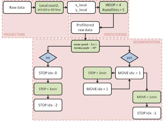
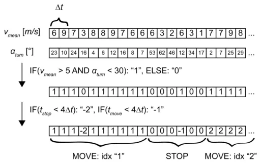
3. Preprocessing and semantic enrichment of movement data 29 3.1. Preprocessing: segmenting stops and moves . . . 29
3.2. From preprocessing to semantic enrichment: a preprocessing workflow 31 3.3. Stops and moves: application of the preprocessing workflow . . . 33
3.4. Exploring effects of preprocessing . . . 36
3.4.1. Quantifying effects of preprocessing . . . 36
3.4.2. Data and experiments . . . 36
3.4.3. Results and discussion . . . 39
3.5. Main findings and contributions . . . 41
4. Concepts for relating movement to geographic context 43 4.1. A movement-context relation matrix . . . 43
4.1.1. The movement axis . . . 43
4.1.2. The context axis . . . 45
4.1.3. Movement-context combinations . . . 45
4.2. Vector-field movement-context relation methods . . . 48
4.3. Move-field movement-context relation methods . . . 49
4.4. Segment-field movement-context relation methods . . . 50
4.5. Polygon-field and field-field movement-context relation methods . . . . 51
5. Relating ungulates’ movement to geographic context 53 5.1. Study area and data . . . 53
5.2. Experiments . . . 54
5.2.1. Validity experiment: Is the movement at all related to the terrain? 54 5.2.2. Sensitivity experiment #1: Differences between relation methods 54 5.2.3. Sensitivity experiment #2: Differences due to varying sector parameters . . . 56
5.3. Results . . . 57
5.3.1. Validity experiment: Is the movement at all related to the terrain? 57 5.3.2. Sensitivity experiment #1: Differences between relation methods 59 5.3.3. Sensitivity experiment #2: Differences due to varying sector parameters . . . 60
5.4. Main findings and contribution . . . 60
6. Relating people’s movement to geographic context 63 6.1. Study area and data . . . 63
6.2. Experiments . . . 64
6.2.1. Relating speed and slope . . . 64
6.2.2. Relating movement to user-generated content . . . 65
6.3. Results . . . 67
6.3.1. Relating speed and slope . . . 67
6.3.2. Relating movement to user-generated content . . . 70
6.4. Main findings and contribution . . . 73
7. Scale effects in context-aware movement analysis 75 7.1. Study area and data . . . 75
7.3. Results . . . 78
7.3.1. Differences due to scales and methods . . . 79
7.3.2. Interdependencies between scales . . . 80
7.4. Main findings and contribution . . . 81
8. Discussion 89 8.1. Effects of preprocessing on context-aware movement analysis . . . 89
8.2. Modeling movement and its embedding geographic context . . . 91
8.3. Methods for relating movement to geographic context . . . 94
8.4. Scale effects in context-aware movement analysis . . . 97
9. Conclusions 99 9.1. Achievements . . . 99
9.2. Insights . . . 101
9.3. Outlook and challenges of future research . . . 102
Bibliography 105
A. Curriculum vitae 117
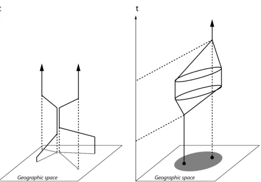
2.1. Concept of space-time cube. Left: grouping of individuals; right: space-time prism, grey: potential path area based on a maximum speed threshold (Source: author’s own graphs according toHägerstrand, 1970). . . 10 2.2. Landform classification with an automated procedure into 8 classes for
the Yatsugatake volcano in Japan (Iwahashi &Pike, 2007). . . 14 2.3. KDD process (according toMiller, 2008, extended version) in relation
to semantic enrichment process (Baglioni et al., 2009). . . 17 2.4. Movement ecology paradigm (Nathan et al., 2008, p.19054). . . 23 3.1. Process chain for the segmentation of stops and moves (author’s own
graph). . . 30 3.2. Illustrative example of the process chain for detecting stops and moves
(author’s own graph). . . 31 3.3. Self-tracking in the city of St. Gallen, Switzerland (author’s own
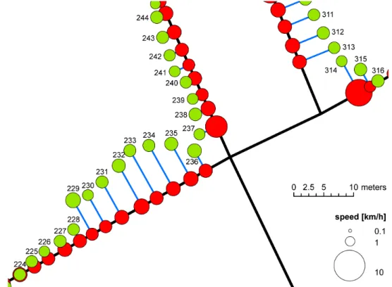
data, 2011). Orange: actual movement path, red: GPS measurements (author’s own data, 2011), map: “Landeskarte 1:25’000” (“Bundesamt für Landestopographie”, 2011). . . 32 3.4. Space-time cube and local scenario in “Neltje Jans” with stops and
moves according to the preprocessing workflow. Grey: short stop/“-2”, white: short move/“-1”, red: stop/“0”, any other color: move/“>1”. Data source: TU Delft, S. van der Spek, 2011. . . 34 3.5. Another local scenario with stops and moves according to the
prepro-cessing workflow. Grey: short stop/“-2”, white: short move/“-1”, red: stop/“0”, any other color: move/“>1”. Data source: TU Delft, S. van der Spek, 2011. . . 35 3.6. Example trajectory section for a pedestrian in Delft, without (green)
and with naïve map matching (red), fix indices at sampling rate of 2 seconds (Data source: van der Spek et al., 2013). . . 38 3.7. Example trajectory of chamois with habitat context in Swiss
Na-tional Park. Stationary fixes (white), moves in various colors (purple, dark blue, dark red, orange, red), and time of day (hh:mm:ss). Data sources: movement data, Swiss National Park (2002-2010); context data, www.habitalp.de (2002-2006). . . 39
3.8. (a) Case study #1, speed for pedestrians; GPS vs. computed; raw data (r), filtered (f) and map-matched (mm). (b) Case study #2, speed vs. habitat for chamois; raw data (r) vs. filtered (f). . . 40 4.1. mc-relation model (“relation matrix”, author’s own graph). . . 46 4.2. Concepts for relating the vector-based movement model to the
em-bedding (field-based) geographic context (mVcF, author’s own graph based on established GIS concepts). . . 48 4.3. Relating (a) move- and (b) segment-based models of movement to
geographic context (author’s own graph based on established GIS concepts). . . 50 4.4. Concepts for movement models based on representations as polygons
or fields and the relation to geographic context: (a) Convex hull, (b) KDE, (c) BBMM and its relation to (d) geographic context (author’s own graph based on established GIS concepts). . . 52 5.1. CRW vs. GPS data of a female ibex (no. 469) in relation to
geomor-phometric landforms byIwahashi& Pike(2007) with a hillshading in the background in Swiss National Park (data sources: GPS data, Swiss National Park, 2006 – 2007; DEM “dtm4”, Swiss National Park, 2010). 55 5.2. Dissolved MCPs per species in Swiss National Park with a hillshading
(data source: DEM “dtm4”, Swiss National Park, 2010). . . 56 5.3. Representations of the movement path of a female chamois (no. 47) in
Swiss National Park. (a) Spatial models with KDE and MCP, and (b) spatio-temporal approach with BBMM (data source: GPS data, Swiss National Park, 2002 – 2004). . . 57 5.4. Histograms representing results of experiments with regard to
VALID-ITY, RELATION METHODS and VARIATION. . . 58 6.1. Different approaches for computing slope and speed (distance). Adapted
fromhttp://www.innovativegis.com/basis/present/gita_denver05/ default.htm, accessed on 29/12/2014. α &β: gradients from DEM,
γ: slope of the beeline, d2D & d3D: 2D and 3D distances between consecutive GPS fixes. . . 65 6.2. Methodology for the relation of movement of pedestrians in Rotterdam
and context in form of Foursquare categories based on KDE (author’s own graph). . . 67 6.3. Correlation of speed (logarithmic scale) and slope using a linear fit
model for bikers and hikers around the Fuorn pass considering two different quantitative models of slope. . . 69
6.4. Correlation of speed (logarithmic scale) and slope using a linear fit model of single down- and uphill trails around the Fuorn pass con-sidering the slope of the beeline. (a) Single downhill trail of a biker, (b) Single uphill trail of a biker, (c) Single downhill trail of a biker for slopes between -40◦ and -10◦, (d) Single downhill trail of a biker for
slopes between -10◦ and -5◦. . . 70
6.5. Correlation of speed (logarithmic scale) and slope using a linear fit model for bikers and hikers around the Fuorn pass considering two different quantitative models of speed. . . 71 6.6. Resulting KDEs for the movement (all data), a Foursquare category
(“shop & service”) and the pairwise multiplication of the two with a small extent of the resulting classification and the original point locations of the “shop & service” Foursquare category. . . 72 6.7. Resulting classification of the relation of movement of pedestrians in
Rotterdam and context in form of Foursquare categories based on KDE. 73 7.1. Aspect represented in 5 classes on different spatial scales (4, 20 and
100 meters), and a chamois’ (no. 22) movement modeled with the Brownian Bridge Movement Model (BBMM) (increasing probability density from black to white) on different temporal scales (10min / 4 h, 30min / 12 h and 1h / 1 day) around the Fuorn pass within the Swiss National Park (purple). . . 76 7.2. Aspect classes at different thematic scales (without class Flat, author’s
own graph). . . 77 7.3. Relative distributions (0-1) of the geographic context (terrain aspect)
in relation to the chamois’ movement. . . 84 7.4. Coefficients of variation representing within-class variation due to
variation of temporal (a) and spatial (b) scale across different thematic scales. . . 85 7.5. Relative distribution of aspect related to the chamois’ movement (with
map pin) for whole year (all), winter and summer (@10min/4h, @4m, @9 categories). . . 86 7.6. Overview of scale effects and interdependencies in relating movement
to geographic context. Green: effects/interdependencies detected, red: no effects/interdependencies detected (author’s own graph). . . 87
3.1. Overview of the pedestrians’ and chamois’ movement data sets (data sources: pedestrians, van der Spek et al., 2013 / chamois, Swiss National Park, 2002 – 2010). . . 37 4.1. Overview of mVcF-relation methods for vector-based movement model
(linked to Figure 4.2). . . 48 5.1. Overview of the ungulates’ movement data sets. . . 53 5.2. Mean and standard deviation and coefficient of variation (in percentage)
of relative frequencies per landform class and species (mean± std and
BBMM Brownian Bridge Movement Model
CAMA Context-Aware Movement Analysis
CRW Correlated Random Walk
DEM Digital Elevation Model
DOP Dilution Of Precision
GIR Geographic Information Retrieval
GIS Geographic Information System
GIScience Geographic Information Science
GKD Geographic Knowledge Discovery
GME Geospatial Modelling Environment
GPS Global Positioning System
HDOP Horizontal Dilution Of Precision
HMM Hidden Markov Model
ICT Information and Communication Technology
IDW Inverse Distance Weighting
IR Information Retrieval
KDD Knowledge Discovery in Databases
KDE Kernel Density Estimation
KDE-DT Kernel Density Estimation-Delaunay Triangulation
LBS Location-Based Service
LBSN Location-Based Social Network
LISA Local Index of Spatial Association
MCP Minimum Convex Polygon
MOD Moving Object Database
MPO Moving Point Object
PDOP Position Dilution Of Precision
POI Point Of Interest
RDF Radial Distance Function
REMO RElative MOtion
RFID Radio-Frequency IDentification
RSF Resource Selection Function
SMoT Stops and Moves of Trajectories
TGDE Time-Geographic Density Estimation
TIN Triangulated Irregular Network
T-OPTICS Trajectory-Ordering Points To Identify the Clustering Structure
UD Utilization Distribution
UGC User Generated Content
Introduction
1.1. Motivation
1.1.1. Why is movement studied?
“Movement is behavior.” (Dodgeet al., 2008, p.245; according toBlythe
et al., 1996)
Movement can be seen as traces of behavior, which is mirrored in the above quote as the key motivation of studying movement. In light of the assumption that individuals’ behavior is reflected in their movement, different research fields – including Geographic Information Science (GIScience), behavioral ecology, urban planning (including studies of urban mobility) and computer science, for example – all contribute to the analysis of movement. Accordingly, movement analysis aims to achieve a better understanding of individuals’ movement in terms of behavior. GIScience and computer science are mainly focused on the development of methodologies that allow the application fields (e.g., behavioral ecology and urban planning) to reveal new insights into movement behavior for addressing problems of animal conservation or urban mobility. In the following paragraphs, motivations specific to the mentioned research fields – and recognized as relevant within the framework of this thesis – are discussed in more detail.
GIScience. GIScience has strong expertise in developing methods for capturing, managing, analyzing, and presenting spatial data (e.g., Clarke, 1995). Besides the spatial component, inherently, movement also has a temporal one; in other words, movement is spatio-temporal and, therewith, is represented with spatio-temporal data. With the strong methodological background, GIScience strengths are also identified in the field of movement analysis. For instance,Imfeld(2000) illustrates (as one of the first) that the expertise of GIScience in analyzing spatial data can be applied and expanded to the spatio-temporal analyses of movement data. Generally, GIScience contributes to movement analysis predominantly based on a methodological motivation.
Behavioral ecology. As the name of the field suggests, this research area is primarily interested in better understanding the impact of evolutionary and environmental
factors on animals’ behavior. Behavioral ecology has a long tradition in observing animals and their behavior in the field (e.g., Hebblewhite & Haydon, 2010). With technological progress allowing for an almost continuous capturing of animals’ movement, new possibilities of studying animals’ behavior have been seen to emerge (e.g.,Tomkiewicz et al., 2010), where movement is supposed to reflect evolutionary
and environmental effects on animals’ behavior.
Urban planning. Urban planners aim to achieve a better understanding of people’s spatio-temporal behavior (e.g.,van der Spek, 2008), in addition to how people use the physical environment (e.g.,van Schaick, 2010) since they seek to design urban areas as efficiently and attractively as possible with regard to residents’ and visitors’ needs. In order to achieve these goals, the study of people’s mobility in urban areas is an established means of garnering greater insights into people’s spatio-temporal behavior – and, finally, in regard to the possible directions of urban planning (e.g.,
van der Spek et al., 2009).
Computer science. Knowledge Discovery in Databases (KDD) is a process concerned with generating knowledge from data (Fayyadet al., 1996). This procedure originated in the context of database research in the area of computer science, and is better known as data mining; importantly, however, data mining is only one aspect of the entire KDD process. KDD and data mining are not only applicable to the use of database structures, but also are applicable to a number of different research fields. Since KDD is used and adapted in mind of addressing geographic questions (within Geographic Knowledge Discovery (GKD),Miller, 2008), data mining is also recognized as relevant with regard to spatio-temporal problems within the analysis of movement (e.g.,Gudmundssonet al., 2008).
This thesis is embedded within the aforementioned research areas, with a strong focus directed towards methodological issues (GIScience). The main methodologically motivated analysis of movement is realized within the application areas, namely behavioral ecology and urban planning, predominantly on the basis of the KDD process, i.e., computer science.
1.1.2. Putting movement into context
Technical progress within Information and Communication Technology (ICT) allows an almost continuous tracking of moving objects in space and time, and accordingly yields a significant potential in terms of assessing movement behavior. Although large volumes of movement data are available, the development of methods for movement analysis with regard to the problems of the application areas is lagging behind, since methodologies differ significantly for different research purposes and application areas. Data mining mainly aims at the detection of movement patterns as a type of aggregation of the movement data in a way that allows humans to better understand the data in terms of movement behavior. Most of the methods put forward thus
far in terms of identifying patterns in movement data, are focused on geometric characteristics and arrangement patterns in movement paths (e.g., Laube et al., 2005). The semantic meaning of such geometric properties has to be approached in order to develop better understanding of movement patterns as movement behavior. Consequently, movement has to be put into the correct context (Purves et al., 2014;
Laube, 2014).
The study of geometric properties of movement paths in particular facilitated the investigation of interaction between different moving objects (e.g., leadership, An-derssonet al., 2008). Andrienkoet al.(2011b) propose an event-based conceptual model for Context-Aware Movement Analysis (CAMA), and validate this model in terms of the real movement data of roe deer, including relations amongst movers (roe deer and lynxes), as well as the relations of the roe deer to spatial locations (e.g., geographic context in form of open areas). However, from a methodological perspective, the movement as a response to other moving entities has been the focus of much more in-depth research than the impact of the physical surrounding environ-ment (geographic context) on actual moveenviron-ment. Thus, this thesis aims at relating movement to its embedding geographic context, thus enabling a better understanding of movement patterns in terms of movement behavior.
1.2. Research gaps and research questions
Besides the well-known data mining, the KDD process also includes equally important issues of background knowledge, preprocessing and knowledge construction (Fayyad
et al., 1996, terminology according to Miller, 2008). Background knowledge and knowledge construction are mainly the expertise of the application areas (e.g. behav-ioral ecology or urban planning). Since GIScience rather focuses on methodological research, the step of preprocessing is particularly relevant for this thesis. Many studies in movement analysis illustrate that, in any case, work based on real movement data always requires preprocessing (e.g., Laube & Purves, 2011). However, although preprocessing is very time-consuming, few details relating to preprocessing steps and their impact on the actual results have been studied in most research of movement analysis. This issue is approached through the application of Research Question 1 (RQ1).
Studies within GIScience often model movement as time-stamped point locations (a triple consisting of spatial coordinates and time as (x, y, t)), where consecutive Global
Positioning System (GPS) records are connected by straight lines, which are usually referred to as trajectories. In other fields, such as behavioral ecology, movement is, amongst others, represented as fields (e.g., BBMM,Horneet al., 2007) or aggregated into polygons (e.g., Minimum Convex Polygon (MCP),Powell, 2000). The selection of a specific movement model over another is very task-dependent. However, the different research fields have in common that they often do not explicitly motivate their choice for representing the movement. As an exception, research within home range analysis leads the way as, in this regard, different estimators are compared
(e.g., Kernel Density Estimation (KDE) vs. MCP, Wartmannet al., 2010). Still, more than one or two models for the representation of movement are rarely discussed and considered in studies of movement analysis. This research gap is addressed with Research Question 2 (RQ2).
With different movement models, different methods for relating this movement (in the form of specific data structures) to its embedding geographic context are required. Moreover, in many studies of movement analysis within GIScience, context in relation to movement is only taken into account in the point locations of the GPS fixes, although the surrounding environment also has an influence on the movement (e.g., Dodge et al., 2012). Similar to the line of argumentation in the course of Research Question 2 (RQ2), within studies of movement analysis, few methods for relating movement to its surrounding geographic context are considered in the actual relation of the two. Research Question 3 (RQ3) addresses this gap by proposing and comparing various quantitative approaches for relating movement to its surrounding geographic context.
Scale issues have been considered in many studies in both GIScience and behavioral ecology (e.g.,Levin, 1992). In the main, the effects of temporal scale (sampling rate of the movement data) (e.g., Laube & Purves, 2011) and movement on different spatio-temporal scales (meters to kilometers and minutes to years) (e.g., Fryxell
et al., 2008) have been investigated in research with regard to movement analysis. Throughout the procedure of relating movement to geographic context, different types of scale of both movement and geographic context come into play. Overall, on different scales, different patterns can be observed, with patterns (e.g., movement patterns) seen to emerge on completely different scales than the processes (e.g., geographic context) that produce them (Levin, 1992). Different sorts of scale as temporal scale of movement, as well as spatial and thematic scale of the context data, have been taken into account – mainly in investigations of behavioral ecology (e.g., Börger
et al., 2006). Nevertheless, different types of scale have been considered very rarely in one single study, and interdependencies between the scales due to the relation of movement to geographic context have been neglected thus far. Accordingly, sensitivity to the relation of movement and geographic context to different types of scale and interdependency between different kinds of scales are addressed in the course of Research Question 4 (RQ4).
In mind of the above, we propose to address the following research questions throughout the completion this thesis:
• RQ1. What is the influence of commonly used preprocessing steps (e.g.,
seg-mentation, map matching) on context-aware movement analysis, and how can it be quantitatively evaluated?
• RQ2. How should movement and the geographic context embedding movement
• RQ3. How can movement – and, explicitly, its spatio-temporality (not only its
mere spatial footprint) – and the geographic context embedding this movement be quantitatively interrelated?
• RQ4. How sensitive is the computation of a quantitative relation between
movement and its embedding context to a systematic variation of the temporal, spatial and thematic scale of analysis, and can interdependencies between the different scale dimensions be identified and quantified?
Within the framework of this thesis, movement is understood to be the change in the spatial location of the entire body of an individual in time (Nathan et al., 2008). Therefore, movement is not intended to be the movement of only parts of an individual’s body: for example, shaking the head without changing spatial location over time is not considered movement within this research of movement analysis.
In this thesis, the methods for the quantitative analyses of relations between movement and geographic context do not intend to assess the relevance of context factors with regard to the movement of specific moving objects; this research rather aims to achieve the quantification of relations between movement and geographic context in an effort to quantitatively confirm educated guesses from within the application areas for the existence of movement-context relations.
The relation of movement and geographic context is assessed in light of the different aspects of the KDD process and methodological issues, such as preprocessing, different models for representing movement and geographic context, and different movement-context relation methods. Furthermore, scale effects with regard to different types of scales of movement and its embedding geographic context are addressed.
Within this thesis, the applied, extended and proposed methods are mainly based on the theoretical framework of the KDD process and data mining. Specifically, the focus lies on spatial, temporal and spatio-temporal methodologies on the basis of concepts from GIScience.
1.3. Structure of the thesis
In the following chapter, a literature review is provided, in an effort to provide a link of relevant theory and to motivate the research questions in greater depth. Chapter 3 presents methods and a case study addressing the various effects of preprocessing on the relation of movement characteristics and geographic context, within which a preprocessing workflow is suggested in mind of the identification of stops and moves. After presenting a movement-context relation framework based on models for movement and geographic context (Chapter 4), this framework is applied on the movement data of ungulates (Chapter 5). Further, in Chapter 6, movement is related to geographic context, utilizing the movement data of pedestrians and outdoor sportsmen in urban and mountainous areas, respectively, with a focus on two examples for modeling geographic context. In Chapter 7, scale effects in the procedure of relating movement to geographic context are assessed. Finally, Chapter
8 provides a discussion of the research questions on a more general level, with the conclusions of this thesis presented in the last chapter (Chapter 9).
Background
2.1. Movement data
2.1.1. Capturing movement data
Different methods can be applied to capture the positional data of moving organisms. Progress in ICT brings about a wealth of advantages and new possibilities; at the same time, however, these have been critically reviewed mainly by biologists (Hebblewhite
& Haydon, 2010; Tomkiewicz et al., 2010; Urbano et al., 2010). Traditionally, behavioral ecologists observe animals and their interactions with one another and to with their environment, directly in the field, and manually register the positions of individuals. Furthermore,Hebblewhite & Haydon(2010) argue that, due to the technical advances in localization techniques, behavioral ecologists spend less time in the field, causing the biological “feel” to be lost in terms of understanding animals in their native environment. On the other hand, however, biologists – specifically those studying organisms in their habitat from single “hotspots” – cannot follow a movement path over a longer period of time owing to, for example, topography, which avoids access to regions where animals still can live, where wide-ranging species as birds were impossible to follow over huge distances – even crossing the sea – without the inventions of ICT approaches. In the case of field observations, behavioral ecologists potentially disturb animals by entering their habitat. The longer term impacts on the behavior of observed animals are reduced by tagging them with GPS collars. From biologists’ perspectives, the main advantage of new localization technologies is predominantly concerned with establishing where animals move, rather than the increasingly finer granularity of GPS-recorded movement data (Hebblewhite &
Haydon, 2010).
Capturing movement data with localization techniques, including GPS and Radio-Frequency IDentification (RFID), leads to growing movement data repositories for different types of moving object, such as various species of animal, pedestrian, bicycle, or car. The shadowing effects caused by mountains in rural regions or buildings in urban areas block the GPS signal, which can have an influence on the quality of data, with indoor measures (mostly in urban areas) in particular recognized as rather inaccurate. The RFID technology also enables the localization of moving objects, and especially is recognized as suitable for indoor environments. However, in comparison with GPS covering localization on the entire globe (Tomkiewiczet al., 2010), the
range of RFID is in the magnitude of meters. The reason for this is that the RFID technique is based on remotely retrieving and storing data using tags and readers, whilst spatial information is derived from the signal strength (Zhou&Shi, 2009). On the other hand, in the case of GPS, the time delay of signals between the satellite and receiver is considered in order to localize moving objects. Nowadays, in many studies taking place in outdoor environments, movement data is recorded by GPS receivers, such as in the domain of wildlife ecology, studying animal behavior (Tomkiewicz
et al., 2010), or studies in urban environments (van Schaick & van der Spek, 2008), for example.
Essentially, there are two perspectives of perceiving movement, theEulerian and theLagrangian view (Turchin, 1998); the former approach investigates movement at fix points in space (e.g., classic field observation of behavioral ecologists), whilst the latter perspective aims at analyzing changes of movement (e.g., speed) along the movement path. In this research project, the focus will be directed towards working with the Lagrangian approach as the modeling of movement paths with Moving Point Objects (MPOs) as trajectories is most suited to the Lagrangian view.
2.1.2. Characteristics of movement data
In the research context of movement analysis, movement is defined as the change of spatial location over time. The change of objects’ geometric form is not in the focus of this research area: for example, moving the upper part of the body without changing spatial location is not understood as movement (Laube, 2009); hence, movement can be modeled as a temporal sequence of geographic point locations, referred to as MPOs. A set of moving points sorted by time is defined as a trajectory. Under the assumption that a MPO moves in a straight direction and at constant speed between two consecutive moving points, it is common to connect consecutive moving points through the use of a straight line (Dodgeet al., 2008).
Naturally, space and time are continuous, whereas movement, on the other hand, cannot be captured and stored on computers as continuous paths (Peuquet, 1994). Technically, there are several methods for recording locations as a discrete subset of the real movement path. Discretization arises in regard to the question of scale, where the choice of a specific temporal scale of movement data depends on the purpose of the movement analysis (Levin, 1992). Most GPS devices register point locations at constant temporal intervals, ranging from fractions of seconds up to hours. This sampling rate, at constant time steps, is understood as the temporal granularity of movement data. Consequently, movement data is also most often modeled as temporal sequence of point locations, comprising a unique identifier, point coordinates of spatial location (where?), time (when?) and a number of additional properties of the MPO itself or of the surroundings (what?), such as in relation to the geographic context embedding the MPO (id,x,y,t,<additional attributes>). In the triad model, Peuquet (1994) distinguishes three fundamental sets for movement: space (where?), time (when?) and objects (what?). The various elements of each set – or the combinations of them (e.g., speed is a combination of elements of space and
time) – can be represented as attributes building a movement dataset (Peuquet, 1994; Andrienkoet al., 2011a).
2.2. About spaces and places
2.2.1. Movement spaces and geographic context
Methods for analyzing movement data towards achieving a better understanding of movement behavior cannot cope with the increasing amounts of movement data facilitated by the technical advances with regard to ICT during the last decade. Methods for movement analysis are sensitive to different movement models (repre-sentations of movement); in turn these can take different forms, depending on how the movement embedding space is modeled (Laube, 2009). To this end, a variety of different movement spaces – such as Euclidean homogeneous space, constrained Euclidean space, space-time aquarium, heterogeneous field space, irregular tesselation and network space – require specific representations of movement, as well as movement analysis methods (Laube, 2014). Through this research project, the focus lies on animals moving in Euclidean (homogeneous) space and on people moving in an urban environment on street networks (network space). A prominent example amongst different models of spaces originates from time geography using the space-time cube.
Hägerstrand(1970) introduced the concept of the space-time cube in the analysis of movement in the context of regional science for policy and planning. The author presents how groupings of several individuals can be visually identified in a kind of tube. Furthermore, the paper establishes the space-time prism based on the potential path area constrained by a maximum speed, depending on the type of MPO (Figure 2.1). Further, irregular tesselation is often applied with movement derived from mobile phone data, where antenna connections are logged over time.
Within GIScience, movement analysis research thus far has been predominantly concerned with algorithmically detecting shape, arrangement, or interaction patterns based on geometric criteria (Laube, 2014). Movement is driven by different factors, including navigation capacity, motion capacity, internal state and external factors (Nathan et al., 2008). Therefore, movement ecology aims at achieving a better understanding of movement as a response to biotic and abiotic external factors, amongst others, whereas biotic external factors can also be referred to the interaction between individuals (second order effects), whilst abiotic external factors can be seen as environmental factors (first order effects) influencing the movement. Relating movement to its embedding geographic context allows for a better understanding of where, when and particularly why individuals move as they do. As a consequence, from a data mining perspective, in movement pattern analysis, the relation of movement patterns to the embedding geographic environment is a key challenge (Gudmundsson
et al., 2008;Purveset al., 2014). The GIScience community has only rarely considered geographic context in the domain of movement analysis (Bitterlichet al., 2009;
Gudmundssonet al., 2012). Earlier,Imfeld(2000) recognized the need for extending the classic Geographic Information System (GIS) toolbox by methodologies allowing
Figure 2.1.: Concept of space-time cube. Left: grouping of individuals; right: space-time prism, grey: potential path area based on a maximum speed threshold (Source: author’s own graphs according toHägerstrand, 1970).
for taking into consideration geographic surroundings for a better understanding of individuals’ movement; therefore, Radial Distance Function (RDF) was developed in mind of quantitatively capturing the geographic surroundings of an MPO.
In movement ecology, movement is linked to environmental factors for gaining a better understanding of processes that have an influence on movement. Movement data can be enriched with environmental data from many sources and many types using remotely sensed data, for example (Demšar et al., 2015). Dodge et al.(2013) implemented an automated system for annotating GPS tracks with environmental variables from global remote sensing, weather, and ecosystem products. With the use of this annotation system in another study, the relation of movement of turkey vultures to environmental conditions revealed correlations explaining how far vultures need to move to find food and how fast they can move depending on thermals and temperature (Dodgeet al., 2014). Moreover, (Morelletet al., 2013) discovered an interesting interplay between home range size and seasonality, weather and climate, using different sources of environmental data (e.g., remote sensing data). These studies illustrate that in recent decades movement ecology underlies remarkable progress in analyzing movement related to environmental factors using ICT technologies; from a methodological point of view, however, there is potential for improvement with regard to the quantitative relation of movement and geographic context, asImfeld(2000) introduced the concept of RDFs in the context of movement analysis already some years ago.