Journal of Chemical and Pharmaceutical Research, 2014, 6(5):1459-1463
Research Article
CODEN(USA) : JCPRC5
ISSN : 0975-7384
Geographic Hypermedia System Model Design and Application
Zhigang Hana
b, Caihui Cui
b, Yunfeng Kong
a,ba
Key Laboratory ofGeospatial Technology For the Middle and Lower Yellow River Regions,
Ministry of Education, Kaifeng, China
b
College of Environmental & Planning, Henan University, Kaifeng, China
_____________________________________________________________________________________________
ABSTRACT
Geographic Hypermedia (GH) is a rich and interactive map document with geo-tagged graphics, sound and video ele-ments. A Geographic Hypermedia System (GHS) is designed to manage, query, display and explore GH resources. Recognizing emerging geo-tagged videos and measurable images as valuable geographic data resources, this paper aims to design a web-based GHS using web mapping, geoprocessing, video streaming and XMLHTTP services. These data can be integrated in HTML pages or used as Rich Internet Appli- cations (RIA) using standard web technologies such as the AJAX, ASP.NET and RIA frameworks. An SOA-based GHS is designed using four types of web services: ArcGIS Server 9.3 web mapping and geoprocessing services, Flash FMS 3.0 video streaming ser- vices and GeoRSS XMLHTTP services.
Keywords: Geographic Video, Data Model, 3D, GIS
_____________________________________________________________________________________________
INTRODUCTION
Promoting dissemination and utilization of geo-graphic information in government, utilities, commerce and general public sectors, raises several challenges in geographic information science. The firstchallenge concerns the appropriate relation between the bird’s eye view and the perspective view of geo-spatial reality. The bird’s eye view offers a 2D geo-spatial model with an accurate representation of locations and spatial relationships. The perspective view offers a 3D model with intuitively ‘true’ visualization. The second challenge concerns defining the relative value of adopting a logical-spatial approach to geo-graphic informationas opposed to a visual-spatialapproach. The logical approach makes possible spatial statistical analysis, modeling and prediction, while the other approach appeals to direct visual understanding. These challenges must be met in both thematic mapping and multimedia presentation. The third challenge is to develop geographic applications not only for communication among professionals, but also for use by the general public. Many social issues are better resolved via public participation rather than via decision making without any consultation. In all cases, 3D modeling, geographic multimedia and virtual/augmented reality, Web 2.0 and other information technologies offer new approaches to meet these challenges. In this paper, it is argued that 3D GIS, multimedia cartography, Web 2.0 mapping and ‘neo- geography’ offer potentials for current geographicapplications. [1-5]
approaches to the design of multimedia mapping products are “maps in multimedia framework” and “multimediain GIS”,The emerging new approach is to publishgeospatial data and multimedia data as web services, and present the data in interactive HTML pages or RIA documents.Geographic Hypermedia (GH), as promoted by Stefanakis and Peterson, attempts to provide a new way for rich, open, flexible and interactive geo- graphic representation.[9] This paper demonstrates aweb-based Geographic Hypermedia System (GHS) design using web mapping, geoprocessing, video streaming and XMLHTTP services. The related data
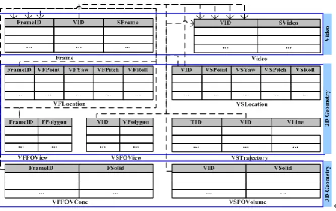
Fig.1: Database representation of 3DGV
Video tables include the frame table and the video table, which are linked by VID property. The primary key of the frame table is FrameID, which is used to link the geometry tables. The video and frame data are stored in the SVideo and SFrame property. The form of video or frame data can be the data path with string type or the LOB type in database.
Geometry tables include the VFLocation/VSLocation table, the VSTrajectory table, the VFFOView/VSFOView table and the VFFOVCone/VSFOVolume table, which are used to store spatial information for the video and frame. The primary key of the VFLocation, VFFOView and VFFOVCone table is FrameID, which refers to the Frame table primary key. The primary key of the VSLocation, VSTrajectory, VSFOView and VSFOVolume table is VID, which refers to the Video table. The spatial data is stored in VFPoint, VSPoint, FPolygon, VPolygon, Vline, FSolid or VSolid with related forms, such as Oracle SDO_Geometry. The camera attitude data is stored in FYaw, FPitch, and FRoll property.
DATA ACQUISITIONOF 3DGV
In order to collect video data with spatial information, the video frame as well as its position and orientation should be collected synchronously. The GPS receiver is used to capture the position, the 3D digital compass is used to collected orientation, and the camera is used to capture video frame. These sensors sampled the data periodically. Due to each sensor having a different sampling rate, e.g., for each second 15 frames of video, 1 GPS position coordinate, and 4 orientation vectors, these raw data might be processed using some numerical methods. Based on the raw information captured by the GPS receiver, compass and camera, the three categories geometry object of 3DGV can be generated using certain methods or algorithms. VFLocation/VSLocation consists of two elements, one being the position of the frame or video segment, the other the orientation of the camera. For a position coordinate, a linear interpolation method is utilized to generate multiple coordinates (equaling with the video frame rate) between two sampling periods of GPS receivers. Given the sampling intervals are short and position changes are even smaller, the orientation information is similar to recent sampling points and might use them. VSTrajectory is the polyline, which consists of VFLocations along with the road. We can generate it directly according to the VFLocation’s sequence.
(fan) as shown in Fig.1.In an ideal situation, the video can be queried through the theoretical field of view based on spatial relationships. But the actual field of view is not a standard fan area because of the existing mutual occlusion relation between the objects (Fig.1). We can calculate the actual FOV via the stereo vision algorithm in the case of the stereoscopic cameras. The actual FOV is closer to the camera's actual field of view with respect to theoretical fan area. And the VFFOViews of the same video segment can be combined to generate the VSFOView. There are the VFFOVCone and VSFOVolume data in 3DGV for video retrieval in 3D space. The theoretical 3D field of view for a given frame is a cone space as shown in Fig.2. The actual 3D field of view for frame or video segment can be generated by the similar methods via the stereo vision algorithm.
Fig.2: Comparison of the actual and theoretical FOV in 2D
Based on the discussion of 3DGV data acquisition, the data collected by the camera, GPS receiver and 3D digital compass are showed as Fig.3.
(a) (b) (c)
(d) (e) (f)
Fig.3: Example of the data of 3DGV
(a. Video Frame Image; b. Location, Trajectory and TheoreticalFOV of Video Frame or Segment; c. Theoretical FOVof Video Segment;
d. Actual FOV of Video Frame; e. Actual FOV of Video Segment; f. Video Frame FOV in 3D)
APPLICATION CASE OF 3DGV
VIDEO QUERY USING GEOGRAPHIC INFORMATION
Select FrameID, VID, SFrame, SVideo from Frame, Video, VFLocation where
ST_distance(q.Geometry,VFPoint)<=d and (abs(azimuthf(VFPoint,q.Geometry)-VFYaw)<=0.5*θ) and
(Frame.FrameID= VFLocation.FrameID) and (Frame.VID=Video.VID)
Where the θ is the camera horizontal FOV angular, azimuthf denotes the function computing the azimuth of the line between q and VFLocation, and abs is the absolute value function.
Fig.4: The direction constraint of the distance query
VIDEO PLAYING WITH GEOGRAPHIC INFORMATION
The video playing is the key for true geographic representation of the real world. Using the 3DGV, the video and its geographic information such as location, trajectories and FOV in 2D/3D can displayed synchronously. This feature is valuable for spatial cognition because of the abstract modeling approach to geographic information as well as the visual-spatial approach. The case is shown in Fig.5. When the video is playing, the current frame location and field of view are drawn on the map synchronously when the video is playing.
Fig.5: The video playing (the 11st frame)
CONCLUSION
In this study, the geographic video 3D data model and the application case with it was introduced. The model was composed of entities of video and geometry. The model objects and their relations were defined in Unified Model Language carefully. At logic levels, 9 core relation tables were designed for application purpose. The data acquisition of the data model was detailed, and then used the GPS receiver to capture the position, and the 3D digital compass to collect the attitude of the camera. We tookan example of the field of view to illustrate the calculation of the theoretical and actual FOV. The application case show that many of the fundamental aspects of our proposed data model can be effectively instantiated. Further development of this model is about the design and implementation of application system as well as the efficiency evaluation.
Acknowledgment
The authors would like to thank the anonymous reviewers for their valuable comments. The work described in this paper is supported by the National Natural Science Foundation of China (grant no. 41201402), China Postdoctoral Science Foundation (grant no. 2013M531666) and Henan University Science Foundation for Young Talents.
REFERENCES
pp.1-31.
[2]Arslan Ay, S. (2010). Leveraging georeferenced meta-data for the management of large video collections. University Of Southern California.
[3]Arslan Ay, S., Zhang, L., Kim, S. H., He, M., & Zimmermann, R. (2009). GRVS: A Georeferenced Video Search Engine. Paper presented at the ACM MM09, pp. 977-978.
Ay, S. A., Zimmermann, R., & Kim, S. H. (2008). Viewable Scene Modeling for Geospatial Video Search. Paper presented at the ACM MM08, pp. 309-318.
[4]Ay, S. A., Zimmermann, R., & Kim, S. H. (2010). Multimedia Systems Journal, 16(2), pp.105-125.