Review Article
Hydrologic Modelling
ARPITA MONDAL1, BALAJI NARASIMHAN2, MUDDU SEKHAR3 and P P MUJUMDAR3,*
1Department of Civil Engineering, Indian Institute of Technology Bombay, Powai, Mumbai 400 076,
India
2Department of Civil Engineering, Indian Institute of Technology Madras, Chennai 600 036, India 3Department of Civil Engineering, Indian Institute of Science Bangalore 560 012, India
(Received on 10 April 2016; Accepted on 10 June 2016)
Advances in computational tools and modelling techniques combined with enhanced process knowledge have, in recent decades, facilitated a rapid progress in hydrologic modelling. From the use of traditional lumped models, the hydrologic science has moved to the much more complex, fully distributed models that exude an enhanced knowledge of hydrologic processes. Despite this progress, uncertainties in hydrologic predictions remain. The Indian contribution to hydrologic science literature in the recent years has been significant, covering areas of surface water, groundwater, climate change impacts and quantification of uncertainties. Future scientific efforts in hydrologic science in India are expected to involve better, more robust observation techniques and datasets, deeper process-knowledge at a range of spatio-temporal scales, understanding links between hydrologic and other natural and human systems, and integrated solutions using multi-disciplinary approaches.
Keywords: Hydrologic Modelling; Surface Water; Groundwater; Climate Change; Uncertainties
*Author for Correspondence: E-mail: [email protected] Introduction
This report presents the progress achieved in India in hydrologic modelling, over the last five years. Indian hydrology, characterized as it is by significant heterogeneities at spatial and temporal scales, offers a fertile ground for useful research contributions. Notable contributions have been made by the hydrologic community in areas covering surface water models, groundwater models, hydrologic impacts of climate change, non-stationarity in hydrologic processes and uncertainty quantification. Large river basins such as the Ganga, Brahmaputra, Mahanadi and Krishna basins have been studied, among others. The following sections provide an overview of recent hydrologic studies carried out in India or with applications pertaining to the Indian region.
Surface Water Modelling
In India, surface water is a major resource to meet different demands and accounts for about 61.5% of
ungauged basins.
During the last decade, thanks to advances in satellite remote sensing, more and more geo-spatial datasets related to hydrology such as topography, land use and soil are becoming widely available through several open sources at free of cost or at a nominal cost. Such datasets aid distributed hydrologic modelling greatly. For example, through an online portal called Bhuvan (http://bhuvan.nrsc.gov.in/), National Remote Sensing Center (NRSC), of the Indian Space Research Organization (ISRO) has made the 10m Digital Elevation Model (DEM) available for the entire country free of cost. Similarly, landuse / landcover datasets are available from NRSC or they may be generated from satellite imagery. Central Water Commission (CWC) of the Ministry of Water Resources (MoWR), Govt. of India and ISRO have developed a web enabled Water Resources Information System in the Country (http:/ /www.india-wris.nrsc.gov.in/). The aim of India-WRIS is to serve as a “single window” for providing comprehensive and consistent data related to water resources at different spatial and time scales. Similarly, international data portals such as USGSearth explorer, Food and Agricultural Organization (FAO), International Water Management Institute (IWMI), World Data Center for Soils (ISRIC) and several other organizations have made a wealth of geo-spatial datasets, though some of them at a coarser spatial resolution, needed for distributed hydrologic modelling for almost free of cost. Access to these open source geo-spatial datasets has stimulated several studies on the development and application of distributed hydrologic model for several river basins across India. However, as a country we still have a long way to go to have an open data policy governing academic research, so that good quality data, especially river discharge and diversion/extraction data,becomes available from government bodies, for increasing the impact of ongoing research by rooting it on measured field data (Mujumdar, 2015).
Due to rapid urbanization and the associated impact of land use change on the hydrology, and with the availability of geo-spatial datasets, there has been increasing interest among the hydrology community in India to use distributed hydrologic models for assessing the impacts due to land use change. The hydrologic model Soil and Water Assessment Tool
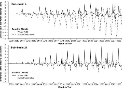
(SWAT) has been used in several studies to understand the impact of landuse/landcover change on the stream flow response (Babar and Ramesh, 2015; Sajikumar and Remya, 2015). The impact specifically due to urbanization on flooding of urban catchment have been investigated by several studies (Zope et al., 2015) using HEC-HMS. Most of the studies related to land use change studied the impacts by simply treating the land use as static between two time periods. This assumption could lead to bias in model parameters during calibration. Wagner et al. (2016) attempted to incorporate the dynamic changes in land use (modelled with SLEUTH)using SWAT to make hydrologic assessment of a rapidly developing catchment near Pune, and found such an approach to be more favorable for assessing seasonal and gradual changes in water balance (Fig. 1). Future studies in landuse/ landcover change and its impact on hydrology can further explore incorporation of dynamic changes within the framework of distributed hydrologic model so that uncertainty in model parameters arising out of static landuse/landcover assumption could be investigated in detail.
Precipitation is one of the hydrologic variables with the highest amount of uncertainty. This is because precipitation is highly variable in both space and time. Although, Indian Meteorological Department (IMD) has a wide network of rain gage(~1289 automatic rain gages and ~675 automatic weather stations, in addition to several hundred non-recording rain gages), there are still regions with sparse rain gage data. In order to overcome this lacuna, few studies have explored using rainfall data from satellite data such as Tropical Rainfall Measurement Mission (TRMM). Indu and Nagesh Kumar (2014) developed a bootstrap approach for assessing sampling errors in satellite derived rainfall products such as TRMM over ungauged basins lacking in situ validation data. Based on the sampling errors, such products may be used for hydrologic modelling. Shah and Mishra (2016a) used rain gauge adjusted TRMM rainfall data with Variable Infiltration Capacity (VIC) model to develop an experimental real-time drought monitor for India.
on development and use of hydrologic models based on radar-rainfall products on real-time suitable for flood prediction, monitoring and management. While there is lot of active research on this topic in North-America and Europe towards development of real-time systems, this is still in its infancy in India. In one of the of the only study till date in India, Josephine et al. (2014) used Doppler Weather Radar data for modelling flood hydrograph caused due to Cyclone “Jal” in the Adyar watershed near Chennai city. However, many more studies are needed within the country to advance the research in this field. Although radar data effectively captures the spatial and temporal pattern of rainfall, much better than the rain gage network, still it suffers from several systematic errors. These errors have to be corrected by developing improved bias adjustment methods (Vieux et al., 2008) specifically for monsoonal climate such as ours.
Groundwater Modelling
In India, groundwater has emerged as the main source of both drinking water and irrigation with an estimated 30 million wells (Shah, 2013). Groundwater is being exploited beyond sustainable levels, which is resulting in loss of functioning wells threatening drinking water supplies and irrigated crops in addition to water quality deterioration. Further, depleted aquifers cause higher greenhouse gas (GHG) emissions (Nayak et al., 2015).
During the last decade an important regional assessment of groundwater depletion was carried using terrestrial water storage-change observations from the NASA Gravity Recovery and Climate Experiment (Rodell et al., 2009) to show that groundwater is being depleted at a mean rate of 17.7 ± 4.5 km3 yr-1 over the Indian states of Rajasthan,
[image:3.612.67.550.81.430.2]Punjab and Haryana. Recently, Papa et al. (2015) Fig. 1: Difference in water yield due to continuous (dynamic) land use representation when compared to the static land use
used a multi-satellite approach to estimate surface freshwater storage (SWS) and subsurface water storage (SSWS) variations over Ganges and Brahmaputra (GB). The monthly SWS variations for the period 2003–2007 at the GB basin-scale showed a mean annual amplitude of <410 km3 and SSWS
mean annual amplitude was estimated to be <550 km3.
Groundwater modelling efforts were made using popular models in various river basins to assess groundwater budgets and ways to improve groundwater resource sustainability. A case study on the semi-arid Musi sub-basin (11,000 Km2) of Krishna basin was performed using three dimensional MODFLOW model (Massuel et al., 2013) and two water allocation scenarios were assessed and compared. Perrin et al. (2012) applied SWAT model in an 84 km2 semi-arid crystalline watershed of
southern India with no perennial surface water source. The model was found to reproduce the recharge rate estimates derived independently by a groundwater balance computation, runoff and surface water storage occurring in tanks that spread along the drainage system, and groundwater table fluctuations monitored at a monthly time step. Results showed that evapotranspiration was by far the largest water flux and the role of percolation tanks was significant as they provide about 23% of the annual aquifer recharge.
Relatively little is known about climate change impacts on groundwater (Green et al., 2011). Changes in land cover, land use and water resource management affect groundwater resources, and these environmental change signals often mask the relatively small climate change signals in groundwater systems there by attribution to climate change quite challenging (Green et al., 2011). The general and the simple approach used to investigate the potential impact of climate change on groundwater fluxes is by forcing the future projections of precipitation and temperature from the global climate models (GCM) into an established groundwater model for a watershed or region (Cambi and Dragoni 2000; Ferrant et al., 2014) illustrated the effects of potential projected climate change on the Kudaliar crystalline aquifer catchment (983 Km2) in Krishna basin and under tropical
semi-arid conditions through downscaled GCM forcing the spatially distributed agro-hydrological model, SWAT. The simulated seasonal groundwater storage for the
historical and future periods averaged over the whole Kudaliar catchment were compared. Nayak et al. (2015) evaluated the impact of climate change on groundwater storage using WEAP model for Joga distributary of Sirhind command area which falls under Satluj basin in India. It was shown that sustainable groundwater use may require a reduction in rice area (by 25%), or the reduction of crop consumptive use through the use of mulches, and improved irrigation technologies for some crops.
Urbanization often modifies the groundwater cycle and induced changes to the groundwater system may be sharp decline or rise of groundwater levels, reduced well yields and deterioration in quality of groundwater. Investigations were made to analyze the groundwater system in urban areas (Srinivasan et al., 2010). The climate change impacts on urban groundwater systems have not received the desired attention. Furthermore, there is yet limited information on addressing impacts from a combination of climate change and management scenarios. Sekhar et al. (2013) investigated the behavior of the groundwater system in a small urban town in a semi-arid hard rock aquifer in south India, wherein the water utility solely depends on groundwater for drinking and other uses and analyzed the impact of combined climate and management scenarios on the hydrogeological system, in particular on the future groundwater declines and vulnerability of the municipal pumping well network.
To get a comprehensive understanding of the impact of climate change on vegetation and soil on to the groundwater system the complex coupled models are run in a distributed framework for a catchment (Mileham, 2009) which requires a series of parameters to be estimated. Instead alternate approaches are being projected wherein the region/ catchment is delineated into zones called the recharge response units (RRUs) or groundwater management units (GMUs) based on climate, land cover, rainfall and soil, a few pivotal locations are selected or identified for each of the zones and the impacts of climate change on the groundwater system were analyzed by using coupled models in a lumped or 1-D approach (Crosbie et al., 2013). An alternative framework that was proposed by Subash et al. (2016) was to study the impact of climate change on groundwater system by using a gridded (e.g. 0.5o x
an approach is that gridded data products for meteorological variables like rainfall, temperature already exist globally with long temporal records ideally suited for climate change studies (e.g. gridded rainfall and temperature products of India’s Meteorological Department (IMD) covering entire India at different resolutions 0.5o or 0.25o, availability
of satellite products such as Tropical Rainfall Measuring Mission, TRMM). Further, a number of large international projects are setup to produce large ensemble of regional based climate models (RCM) for use in impact studies NARCCAP (North American Regional Climate Change Assessment Program) inter-comparison project, ENSEMBLES and CORDEX. Generating a robust gridded groundwater level time series is more likely feasible option, when the
groundwater monitoring networks are evolving and sparse. Further, the benefit of zonal groundwaterlevels is that they provide a better representation of the specific yield and pumping for the region or the grid. Since the GCM simulated variables are available for a grid, having grid based groundwater data would also eliminate downscaling of rainfall from GCM to a point or a pivot. In addition, the simulations of groundwater storage time series performed over grids of 0.5o or
0.25o using this approach would be of great utility to downscale or debias the storage dynamics obtained from GRACE products.
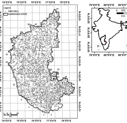
[image:5.612.86.506.315.723.2]An example of modelling the impacts of climate change on a gridded groundwater system is presented here. Fig. 2 presents the 0.5o x 0.5o grids for the
Karnataka state along with groundwater level monitoring network of Department of Mines and Geology, Government of Karnataka. For illustration the grid numbered 6 was chosen here. The gridded groundwater level time series is shown in Fig. 3 for grid 6 along with monthly rainfall. The block Kriged monthly rainfall is generated using the 0.25o x 0.25o
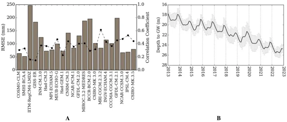
resolution rainfall of APHRODITE (1976-2005) and TRMM_3B43 (2006-2012). The AMBHAS-1D model (Subash et al. 2016) was used to simulate the groundwater levels and its performance is shown in Fig. 3. Correlation coefficient and RMSE with the observed rainfall for the period 1976-2005 is shown in Fig. 4 using 19 GCMs and 3 RCMs for the grid 6. Future groundwater levels were simulated using the GCMs and RCMs, which resulted in correlation coefficient of 0.4 and the mean and standard deviation of groundwater levels are shown Fig. 4. This demonstrates an approach of analyzing climate change impacts on stressed groundwater regions using aggregated groundwater data. Going forward, studies must focus on approaches to arrive at scenarios of future pumping based on land cover changes and irrigation amounts taking into account newer technologies and improved land management practices.
Climate Change Impacts and Hydrologic Extremes
Long-term changes in the climate system due to natural or forced variability is expected to alter the hydrologic cycle. For a rapidly developing country such as India where natural resources such as water might already be in a state of stress, climate change in conjunction with concurrent confounding factors like urbanization and industrial growth can have a significant impact on the society. While natural climate variability is known to drive the hydrological cycle in a steady manner over time, hydrologic impact of anthropogenic climate change due to greenhouse gas emissions remain of particular concern to the scientific community and the water managers. Large-scale changes in the earth’s climate system have been attributed to human-induced climate change (Bindoff et al., 2013). Starting from the early days of linking increases in only global average temperature with greenhouse gas emissions, climate scientists have come a long way in establishing the anthropogenic effects on several aspects of the earth system as part
of a coherent story.
Hydrologists, however, are typically interested in smaller spatio-temporal scales, such as discharge in a watershed, where it is increasingly difficult to attribute historically observed changes to human-induced climate change because of the interplay of several causal factors including large natural variability noise and local human interventions and regulations. In addition to investigating long-term changes through detection and attribution (D&A) studies (Hegerl et al., 1996), recent research efforts also attempt to quantify human effects on individual hydroclimatic extreme events to evaluate how much more likely the event became because of anthropogenic climate change through a probabilistic event attribution (PEA) framework (Stott et al., 2004). The global climate model simulations play a central role in attribution studies as they can be used to obtain patterns of the earth’s climate system with or without particular forcings. These patterns are thereafter searched in the actual observations to conclude whether signals of such forcings are detectable.
However, the GCMs operate at coarser resolutions; therefore, they cannot represent fine-resolution processes and cannot provide at-site estimates of hydrologic variables. This scale and physical-process mismatch can be addressed to facilitate comparisons between coarse scale model simulations and fine-scale observations by downscaling methods. While dynamic downscaling involves running regional climate models (RCMs) nested within the GCMs, to capture local features, statistical downscaling constitutes fitting a relationship between large scale climate predictors and small-scale hydrologic predictands. Physically-based hydrologic models or other impact models can be further used in conjunction with climate model simulations to obtain regional variables of interest.
and streamflow, hydrologists are also interested in studying water quality, groundwater levels, and hydroclimatic extremes such as short duration high intensity rainfall, floods or droughts, under climate change.
Finally, for effective water management taking all these factors into consideration, robust measures of hydrologic risk are required for designs under climate change. The traditional assumption of stationarity on which hydrologic designs are based, implies that the past can be a guide to the future.
However, this assumption needs to be re-evaluated under changing climate conditions and therefore, newer, more robust methods need to be formulated for defining hydrologic design levels.
[image:7.612.72.550.81.290.2]Here we discuss recent research efforts with specific applications in the Indian region, towards addressing the scientific aspects described above. Uncertainties related to the use of climate models, downscaling, emission scenarios or hydrologic models are dealt separately subsequently.
Fig. 3: Groundwater level time series (circle markers) for grid 6 along with monthly rainfall. Also shown is the modeled groundwater levels (thick line)
Fig. 4: (A) Correlation and RMSE of RCMs and GCMs with the observed rainfall for the period 1976-2005, (B) Simulated future groundwater levels (mean and standard deviation) using GCMs and RCMs whose correlation coefficient was above 0.4
[image:7.612.68.546.325.528.2]Climate Change Detection and Attribution
Several studies in the recent times examined changes in hydroclimatologic variables in different parts of the country and possible links with climate change: while some investigated long term trends in rainfall or temperature over relatively larger spatial scales (Kumar et al., 2010; Jain and Kumar, 2012; Sonali and Nagesh Kumar, 2013; Kothawale et al., 2010; Mondal et al., 2015, etc.), others focused on specific regions (Kumar and Jain, 2010; Singh and Mal, 2014; Jain et al., 2013; Adarsh and Janga Reddy, 2015; Thomas and Prasannakumar, 2016, etc.) or particular aspects of the monsoon system (Sahana et al., 2015; Turner and Annamalai, 2012; Dash et al., 2015; Bollasina et al., 2013) or hydroclimatic extremes (Goswami et al., 2006; Rajeevan et al., 2008; Ghosh et al., 2012; Guhathakurta et al., 2011; Krishnaswamy et al., 2015; Mondal and Mujumdar, 2015a; Vinnarasi and Dhanya, 2016; Deshpande et al., 2016 etc.). However, only a handful of studies attempt a formal fingerprint-based attribution analysis to categorically link anthropogenic climate change with observed changes in hydrologic variables in India. While Lau and Kim (2010) attribute trends in Indian monsoon to anthropogenic aerosols, Mondal and Mujumdar (2012) concluded, through a detection and attribution analysis on monsoon precipitation and streamflow in the Mahanadi River Basin, that at local scales human-induced climate change signals may not be unequivocally identified in hydrologic observations. Sonali and Nagesh Kumar (2015) inferred that changes in extreme temperatures over India lie outside the range of natural climate variability, while Mondal and Mujumdar (2015b) highlight the difficulties in uniquely attributing changes in extreme rainfall over India to anthropogenic greenhouse gas emissions.
Although extreme hydroclimatic events are often encountered in India - some examples include flooding in Mumbai and Chennai in 2005 and 2015 respectively or the heat wave in Northern and Eastern India in 2015 that resulted in huge societal losses, PEA, for investigating how these individual events were influenced by human-induced climate change, is relatively unexplored in this country. Across the globe,a handful of extreme events are deemed to be made more likely by anthropogenic climate change: they include the 2003 European heat wave (Stott et al.,
2004), 2000 European floods (Pall et al., 2011), 2010 Russian heat wave (Otto et al., 2012) 2011 East African drought (Lott et al., 2013) and 2014 England winter floods (Schaller et al., 2016). In the Indian context, Cho et al. (2015) could establish a link between anthropogenic greenhouse emissions and aerosols and the June 2013 heavy rainfall and flooding in Northern India, while Singh et al. (2014) conclude that the same event was at least a century time-scale event and the evidence for increased probability of such an event in the recent times because of increased human influence is equivocal. Relatively short good quality observational records and computation-exhaustive modelling exercise and related uncertainties pose challenge for PEA analysis for extreme events in India.
Hydrologic Impacts of Climate Change
Impact of Climate Change: Hydroclimatic Extremes and Non-stationarity
Extreme events such as very heavy rainfall, floods, droughts or heat waves are overly important as they can have devastating effects on lives and property; yet, at the same time, their behavior is difficult to be understood as they are rare by their very definition. Moreover, traditional hydrologic designs are based on the assumptions of stationarity which can be questionable under changing climate conditions. For example, the definition of a 100-year flood changes if the probability of its exceedance changes with time. Two interpretations of return period based on expected waiting time and expected number of events respectively, can be extended to the non-stationary conditions. Moreover, some recent studies also propose the probability of failure (Rootzen and Katz, 2013; Serinaldi, 2015) as a more robust measure of hydrologic risk as compared to return period and return level. Mondal and Mujumdar (2016) present a comparison of these novel risk measures for non-stationary conditions for extreme rainfall at a location in South-Western India and conclude that under confounding uncertainties, further investigation is required to arrive at the ‘best’ estimate of hydrologic risk under climate change. Indeed, statistical parameter uncertainty (or sampling variability) is an important aspect for hydrologic designs and constitutes an additional source of uncertainty along with other uncertainties discussed in the next section. For precipitation intensity-duration-frequency relationships that have implications for urban infrastructure designs, Chandra et al. (2015) in fact show that statistical parameter uncertainty can indeed be higher than GCM uncertainties for short duration high intensity precipitation.
Uncertainty Modelling
Uncertainties at all stages of hydrologic modelling, from state estimation to parameter estimation and system identification pose a major challenge to hydrologists in communicating the predictions with confidence. In the Indian context, missing data, small samples of data and unacceptable quality of data pose another – and a significant – source of uncertainty as model calibration and validation are based on such datasets. Use of GCMs, scenarios and downscaling
methods in obtaining hydrologic projections under climate change introduces a significant uncertainty in the projections. This section describes the work carried out in India over the last about five years on quantification of uncertainties in hydrologic impacts of climate change and in modelling hydrologic processes.
Uncertainties in Climate Change Impacts
Uncertainties in projections of hydrologic responses to climate change arise from various sources including limitations in scientific knowledge (for example, effect of aerosols) and human actions (such as future greenhouse gas emissions). These two forms of uncertainties are classified generally as model uncertainty and scenario uncertainty respectively. Downscaling of GCM outputs to station-scale hydrologic variables using statistical relationships introduces an additional source uncertainty. Another source of uncertainty arises from the hydrological modelling itself.
Uncertainty Combination: GCM, Scenario and Downscaling Uncertainty
Assessing regional hydrologic impacts of climate change through downscaling adds another source of uncertainty, through the choice of downscaling method. Combination of model, scenario and downscaling uncertainties has been studied using the Dempster-Shafer theory and natural variability linkages have been used for constraining uncertainty in regional impacts (Raje and Mujumdar, 2010a, b). The Dempster-Shafer (D-S) theory or the theory of belief functions is a mathematical theory of evidence which can be interpreted as a generalization of probability theory. The D-S theory provides methods to represent and combine weights of evidence. A case study for the uncertainty quantification methodology is presented for projecting streamflow of Mahanadi River at the Hirakud reservoir (Raje and Mujumdar, 2010b). A conditional Random Field (CRF) based downscaling is used to account for downscaling uncertainty. The Standardized Streamflow Index (SSFI), which is similar to the more commonly used Standardized Precipitation Index (SPI) is adopted to describe the hydrologic droughts. Each scenario-GCM gives a projected range of future CDFs for SSFI-4 classifications. The DSSs obtained from all scenarios for a particular GCM are first combined by assigning equal weights to each scenario, and then a combination across all models is carried out to provide a band of uncertainty in the projections.
In addition to GCM and scenario uncertainty, uncertainty in the downscaling relationship itself is explored by linkages to changes in frequencies of modes of natural variability. Raje and Mujumdar (2010a) demonstrated that incorporating changes in projected frequencies of natural regimes, and applying a novel constraint of GCM performance with respect to natural variability, results in a large reduction in uncertainty in regional hydrologic prediction, in the Mahanadi basin. Kannan et al. (2014) recognized another source of uncertainty resulting from use of multiple data sets and reanalysis products in impact assessment, in simulating the 21st century Indian
Summer Monsoon Rainfall (ISMR). They observed that the uncertainty resulting from use of different data sets and reanalysis data sets is comparable to that resulting from multiple GCMs, and thus should not be ignored in impact studies.
The Coordinated Regional Climate Downscaling Experiment (CORDEX) South Asian Experiment provides downscaled projections on temperature and precipitation useful in hydrologic impact assessment. The simulations from CORDEX over the historical period have been shown to differ significantly from the observed data in several regions (e.g., Chawla and Mujumdar, 2015; Mishra, 2015). Mishra (2015) showed that the CORDEX-RCMs overestimate observed warming by threefold in Ganges and Brahmaputra basins. The CORDEX-RCMs showed larger uncertainty at the lower elevations in both precipitation as well as temperature, while the observed data sets showed larger uncertainty with increase in elevation, perhaps because of the sparse data in the higher elevations. An interesting observation of Mishra (2015) is that the parent GCMs from which the CORDEX RCMs are derived show a better performance in simulating winter climate than the CORDEX-RCMs, which suggest that an improved representation of elevation may not necessarily improve the model’s performance.
An important recent work on uncertainty quantification in climate change impacts is by Singh and Kumar (2015) who presented a probabilistic Budyko framework to derive estimates of water availability across India with quantification of associated uncertainty. They conclude that southern India is most susceptible to changing climate with less than 10% decrease in precipitation causing a 25% decrease in water availability.
Hydrologic Model Uncertainties
the parameter uncertainty in the hydrologic models, they observed that uncertainty introduced due to choice of GCM, is larger than that due to parameter uncertainty for the VIC model, when it is used for climate change impact assessment. Dhanya and Kumar (2011) have used a novel approach of ensemble wavelet networks to quantify the predictive uncertainty of daily streamflow in the Mahanadi Riverbasin, displaying a chaotic behavior. They observed that the total predictive uncertainty in the streamflow is reduced when modeled with ensemble wavelet networks with different lead times. Other recent studies addressing uncertainty in modelling hydrologic variables include those by Barua et al. (2010), Panda et al., (2013) and Shah and Mishra (2016b).
Concluding Remarks
While a significant progress has been achieved in hydrologic modelling of Indian river and aquifer systems, the models may be constrained by sparse observation networks. A commensurate effort is needed on developing well instrumented watersheds to measure surface and groundwater fluxes to enhance the growth of hydrologic science. The knowledge generated through such controlled watersheds could then be exploited to upscale the processes with suitable parameterization to larger scales. Advances achieved in addressing non-stationarity and quantification of uncertainties should facilitate such multiscale hydrologic modelling. Finally, an end-to-end analysis can be achieved by integrating advances in hydrologic modelling with those in closely related disciplines such as ecology, atmospheric science, geomorphology, and mathematical and social sciences.
References
Adarsh S and Janga Reddy M (2015) Trend analysis of rainfall in four meteorological subdivisions of southern India using nonparametric methods and discrete wavelet transforms International Journal of Climatology 35 1107-1124
Babar S and Ramesh H (2015) Streamflow response to land use-land cover change over the Nethravathi River Basin, India
Journal of Hydrologic Engineering 20 05015002 doi:
10.1061/(ASCE)HE.1943-5584.0001177
Barua A, Majumder M and Das R (2010) Estimating spatial variation of river discharge in face of desertification induced uncertainty In Impact of Climate Change on Natural
Resource Management (pp. 111-130) Eds : Jana, Bipal
Kumar and Majumder, Mrinmay, Springer, Netherlands
Bindoff N L, Stott P A, Achuta Rao K M, Allen M R, Gillett N, Gutzler D, Hansingo K, Hegerl G, Hu Y, Jain S, Mokhov I I, Overland J, Perlwitz J, Sebbari R and Zhang X (2013) Detection and Attribution of Climate Change: from Global to Regional. In T F Stocker, D Qin, G -K Plattner, M Tignor, S K Allen, J Boschung, A Nauels, Y Xia, V Bexand P M Midgley (Eds.), Climate Change 2013: The Physical
Science Basis. Contribution of Working Group I to the Fifth Assessment and Ramaswamy Report of the Intergovernmental Panel on Climate Change, Cambridge,
United Kingdom and New York, NY, USA: Cambridge
University Press
Bollasina M A and Ming Y V (2013) Earlier onset of the Indian monsoon in the late twentieth century: The role of anthropogenic aerosols Geophysical Research Letters 40 3715-3720
Cambi C and Dragoni W (2000) Groundwater, recharge variability and climatic changes: some consideration out of the modelling of an appenninic spring Hydrogeology 4 39-53
Chandra R, Saha U and Mujumdar P P (2015) Model and parameter uncertainty in IDF relationships under climate change Advances in Water Resources 79 127-139
Chawla Ila and Mujumdar P P (2015) Isolating the Impacts of land Use and Climate Change on Streamflow Hydrology
and Earth System Sciences 19 3633-3651 doi:10.5194/
hess-19-3633-2015
Cho C, Li R, Wang S-Y, Yoon J-H and Gillies R R (2015) Anthropogenic footprint of climate change in the June 2013 northern India flood Climate Dynamics 46 797-805
Crosbie R S, Scanlon B R, Mpelasoka F S, Reedy R C, Gates J B and Zhang L (2013) Potential climate change effects on groundwater recharge in the High Plains Aquifer USA Water
Resources Research 49 3936-3951
Dash S K, Mishra S K, Pattnayak K C, Mamgain A, Mariotti L, Coppola E, Giorgi F and Giuliani G (2015) Projected seasonal mean summer monsoon over India and adjoining regions for the twenty-first century Theoretical and
Applied Climatology 122 581-593
Deshpande N R, Kothawale D R and Kulkarni A (2016) Changes in climate extremes over major river basins of India International Journal of Climatology doi: 10.1002/ joc.4651
Dhanya C T and Nagesh Kumar D (2011) Predictive uncertainty of chaotic daily streamflow using ensemble wavelet networks approach Water Resources Research 47 W06507, 1-28
Dimri A P, Yasunari T, Wiltshire A, Kumar P, Mathison C, Ridley J and Jacob D (2013) Application of regional climate models to the Indian winter monsoon over the western Himalayas
Science of The Total Environment 468 S36-S47
Ferrant S, Caballero Y, Perrin J, Gascoin S, Dewandel B, Aulong S, Dazin F, Ahmed S and Marechal J C (2014) Projected impacts of climate change on farmers’ extraction of groundwater from crystalline aquifers in South India
Scientific reports 4 1-10
Ghosh S and Katkar S (2012) Modelling uncertainty resulting from multiple downscaling methods in assessing hydrological impacts of climate change Water Resources
Management 26 3559-3579
Ghosh S, Das D, Kao S C and Ganguly A R (2012) Lack of uniform trends but increasing spatial variability in observed Indian rainfall extremes Nature Climate Change 2 86-91
Gosain A K, Rao S and Arora A (2011) Climate change impact assessment of water resources of India Current Science 101 356-371
Goswami B N, Venugopal V, Sengupta D, Madhusoodanan M S and Xavier P K (2006) Increasing trend of extreme rain events over India in a warming environment Science 314 1442-1445
Green T R, Taniguchi M, Kooi H, Gurdak J J, Allen D M, Hiscock K M, Treidel H and Aureli A (2011) Beneath the surface of global change: Impacts of climate change on groundwater
Journal of Hydrology 405 532-560
Guhathakurta P, Sreejith O P and Menon P A (2011) Impact of climate change on extreme rainfall events and flood risk in India Journal of earth system science 120 359-373
Hegerl G C, von Storch H, Hasselmann K, Santer B D, Cubasch U and Jones P D (1996) Detecting greenhouse-gas-induced climate change with an optimal fingerprint method Journal
of Climate 9 2281-2306
Huggel C, Stone D, Auffhammer M and Hansen G (2013) Loss and damage attribution Nature Climate Change 3 694-696
Indu J and Nagesh Kumar D (2014) Evaluation of TRMM PR sampling error over a subtropical basin using bootstrap technique IEEE Transactions on Geoscience and Remote
Sensing 52 art. no. 6757000, pp. 6870-6881 DOI: 10.1109/
TGRS.2014.2304466
Islam A, Sikka A K, Saha B and Singh A (2012) Streamflow response to climate change in the Brahmani River Basin, India Water resources management 26 1409-1424
Jain S K and Kumar V (2012) Trend analysis of rainfall and temperature data for India Current Science 102 37-49
Jain S K, Kumar V and Saharia M (2013) Analysis of rainfall and temperature trends in northeast India International Journal
of Climatology 33 968-978
Josephine Vanaja S, Mudgal B V and Thampi S B (2014) Rainfall-runoff modelling using Doppler weather radar data for Adyar watershed, India Mausam 65 49-56
Kannan S, Ghosh S, Mishra V and Salvi K (2014) Uncertainty resulting from multiple data usage in statistical downscaling
Geophys Res Lett 41 4013-4019 doi: 10.1002/2014
GL060089
Kothawale D R, Revadekar J V and Kumar K R (2010) Recent trends in pre-monsoon daily temperature extremes over India Journal of Earth System Science 119 51-65
Krajewski W F and Smith J A (2002) Radar hydrology: rainfall estimation, Advances in Water Resources 25 Issues 8-12, August-December 2002, Pages 1387-1394, ISSN 0309-1708, http://dx.doi.org/10.1016/S0309-1708(02)00062-3
Krishnaswamy J, Vaidyanathan S, Rajagopalan B, Bonell M, Sankaran M, Bhalla R S, and Badiger S (2015) Non-stationary and non-linear influence of ENSO and Indian Ocean Dipole on the variability of Indian monsoon rainfall and extreme rain events Climate Dynamics 45 175-184
Kumar Raju and Nandagiri L (2015) Evaluating Uncertainty of the Soil and Water Assessment Tool (SWAT) Model in the Upper Cauvery Basin, Karnataka, India International
Journal of Earth Sciences and Engineering 08c August
2015
Kumar A (2014) Geomorphologic Instantaneous Unit Hydrograph Based Hydrologic Response Models for Ungauged Hilly Watersheds in India Water Resources
Management 29 863-883 DOI:
10.1007/s11269-014-0848-z
Kumar V, Jain S K and Singh Y (2010) Analysis of long-term rainfall trends in India Hydrological Sciences
Journal-Journal des Sciences Hydrologiques 55 484-496
Lau W K and Kim K M (2010) Fingerprinting the impacts of aerosols on long term trends of the Indian summer monsoon regional rainfall Geophysical Research Letters 37
Lott F C, Christidis N and Stott P A (2013) Can the 2011 East African drought be attributed to human induced climate change? Geophysical Research Letters 40 1177-1181
Massuel S, George B A and Venot J-P, Bharati L and Acharya S (2013) Improving assessment of groundwater-resource sustainability with deterministic modelling: a case study of the semi-arid Musi sub-basin, South India Hydrogeology
Journal 21 1567-1580
Menon A, Levermann A, Schewe J, Lehmann J and Frieler K (2013) Consistent increase in Indian monsoon rainfall and its variability across CMIP-5 models Earth System
Dynamics 4 287-300
Mileham L, Taylor R G, Todd M, Tindimugaya C and Thompson J (2009) The impact of climate change on groundwater recharge and runoff in a humid, equatorial catchment: sensitivity of projections to rainfall intensity Hydrol Sci J 54 727-738
Mishra V (2015) Climatic uncertainty in Himalayan water towers
Journal of Geophysical Research: Atmospheres 120
2689-2705
Mishra V, Kumar D, Ganguly A R, Sanjay J, Mujumdar M, Krishnan R and Shah R D (2014) Reliability of regional and global climate models to simulate precipitation extremes over India Journal of Geophysical Research: Atmospheres 119 9301-9323
Mondal A and Mujumdar P P (2012) On the basin scale detection and attribution of human induced climate change in monsoon precipitation and streamflow Water Resources
Research 48 W10520
Mondal A and Mujumdar P P (2015a) On the detection of human influence in extreme precipitation over India Journal of
Hydrology 5291161-1172
Mondal A and Mujumdar P P (2015b) Modelling non-stationarity in intensity, duration and frequency of extreme rainfall over India Journal of Hydrology 521 217-231
Mondal A and Mujumdar P P (2016) Extreme value analysis for modelling non-stationary hydrologic change. In Shafiqul Islam and KavehMadani (Eds.) Contingent Complexity and
Prospects for Water Diplomacy: Understanding and Managing Risks and Opportunities for an Uncertain Water Future Anthem Water Diplomacy Series (in press)
Mondal A, Khare D and Kundu S (2015) Spatial and temporal analysis of rainfall and temperature trend of India
Theoretical and Applied Climatology 122 143-158
Mondal A, Khare D, Kundu S, Meena P K, Mishra P K and Shukla R (2014) Impact of climate change on future soil erosion in different slope, land use, and soil-type conditions in a part of the Narmada River Basin, India Journal of
Hydrologic Engineering 20 C5014003
Mujumdar P P (2015) Impetus to Hydrology Current Science 109 235-236
Mujumdar P P and NageshKumar D (2012) Floods in a Changing
Climate: Hydrologic Modelling, International Hydrology
Series, Cambridge University Press, Cambridge, U.K., ISBN-13: 9781107018761
Narsimlu B, Gosain A K and Chahar B R (2013) Assessment of future climate change impacts on water resources of upper sind river basin, India using SWAT model Water Resources
management 27 3647-3662
Nayak P C, Wardlaw R and Kharya A K (2015) Water balance approach to study the effect of climate change on groundwater storage for Sirhind command area in India.
International Journal of River Basin Management 13
243-261
Otto F E, Massey N, van Oldenborgh G J, Jones R G and Allen M R (2012) Reconciling two approaches to attribution of the 2010 Russian heat wave Geophysical Research
Letters 39 L04702
Pall P, Aina T, Stone D A, Stott P A, Nozawa T, Hilberts A G and Allen M R (2011) Anthropogenic greenhouse gas contribution to flood risk in England and Wales in autumn 2000 Nature 470 382-385
Panda D K, Kumar A, Ghosh S and Mohanty R K (2013) Streamflow trends in the Mahanadi River basin (India): Linkages to tropical climate variability Journal of
Hydrology 495 135-149
Panwar S and Chakrapani G J (2013) Climate change and its influence on groundwater resources Current Science 105 37-46
Papa F, Frappart F, Malbeteau Y, Shamsudduha M, Venugopal V, Sekhar M, Ramillien G, Prigent C, Aires F, Pandey R K, Bala K and Calmant S (2015) Satellite-derived surface and sub-surface water storage in the Ganges-Brahmaputra river basin Journal of Hydrology-Regional Studies http:// dx.doi.org/10.1016/j.ejrh.2015.03.004
semi-distributed model Journal of Hydrology 460-461 143-155
Raje D and Krishnan R (2012) Bayesian parameter uncertainty modelling in a macroscale hydrologic model and its impact on Indian river basin hydrology under climate change Water
Resources Research 48
Raje D and Mujumdar P P (2010a) “Constraining uncertainty in regional hydrologic impacts of climate change: Nonstationarity in downscaling.” Water Resources
Research 46 W07543 doi:10.1029/2009WR008425
Raje D and Mujumdar P P (2010b) “Hydrologic drought prediction under climate change: Uncertainty modelling with Dempster-Shafer and Bayesian approaches.”
Advances in Water Resources doi:10.1016/
j.advwatres.2010.08.001
Raje D and Mujumdar P P (2011) A Comparison of Three Methods for Downscaling Daily Precipitation in the Punjab Region Hydrological Processes 25 3575-3589
Raje D, Priya P and Krishnan R (2014) Macroscale hydrological modelling approach for study of large scale hydrologic impacts under climate change in Indian river basins Hydrological Processes 28 1874-1889
Rajeevan M, Bhate J and Jaswal A K (2008) Analysis of variability and trends of extreme rainfall events over India using 104 years of gridded daily rainfall data Geophysical Research
letters 35 L18707
Rehana S and Mujumdar P P (2012) Climate change induced risk in water quality control problems Journal of
Hydrology 444 63-77
Rehana S and Mujumdar P P (2013) Regional impacts of climate change on irrigation water demands Hydrological
Processes 27 2918-2933
Rodell M, Velicogna I and Famiglietti J S (2009) Satellite-based estimates of groundwater depletion in India Nature 460 999-1002
Rootzén H and Katz R W (2013) Design life level: quantifying risk in a changing climate Water Resources Research 49 5964-5972
Saha A, Ghosh S, Sahana A S and Rao E P (2014) Failure of CMIP5 climate models in simulating post 1950 decreasing trend of Indian monsoon Geophysical Research Letters 41 7323-7330
Sahana A S, Ghosh S, Ganguly A and Murtugudde R (2015) Shift in Indian summer monsoon onset during 1976/ 1977 Environmental Research Letters 10 054006
Sahoo B, Chatterjee C, Raghuwanshi N S, Singh R and Kumar R
(2006) Flood estimation by GIUH-based clark and nash models Journal of Hydrologic Engineering 11 515-525
Sajikumar N and Remya R S (2015) Impact of land cover and land use change on runoff characteristics Journal of
Environmental Management 161 460-468 DOI: 10.1016/
j.jenvman.2014.12.041
Salvi K and Ghosh S (2013) High-resolution multisite daily rainfall projections in India with statistical downscaling for climate change impacts assessment Journal of Geophysical
Research: Atmospheres 118 3557-3578
Schaller N, Kay A L, Lamb R, Massey N R, van Oldenborgh G J, Otto F E L, Sparrow S N, Vautard R, Yiou P, Ashpole I, Bowery A, Crooks S M, Haustein K, Huntingford C, Ingram W J, Jones R G, Legg T, Miller J, Skeggs J, Wallom D, Weisheimer A, Wilson S, Stott P A and Allen M R (2016) Human influence on climate in the 2014 southern England winter floods and their impacts Nature Climate
Change doi:10.1038/nclimate2927
Sekhar M, Shindekar M, Tomer S K and Goswami P (2013) Modelling the vulnerability of an urban groundwater system due to the combined impacts of climate change and management Scenarios Earth Interactions 17 1-25
Serinaldi F (2015) Dismissing return periods! Stochastic
Environmental Research and Risk Assessment 29
1179-1189
Shah M (2013) Water: Towards a Paradigm Shift in the Twelfth Plan, Economic and Political Weekly XLVIII 40 40-52
Shah T (2009) Climate change and groundwater: India’s opportunities for mitigation and adaptation Environmental
Research Letters 4 035005
Shah R D and Mishra V (2016a) Development of an experimental near-real-time drought monitor for India Journal of
Hydrometeorology 16 327-345. DOI:
10.1175/JHM-D-14-0041.1
Shah H L and Mishra V (2016b) Uncertainty and Bias in Satellite-based Precipitation Estimates over Indian Sub-continental Basins: Implications for Real time Streamflow Simulation and Flood Prediction Journal of Hydrometeorology 17 615-636 DOI: 10.1175/JHM-D-15-0115.1
Shashikanth K, Madhusoodhanan C G, Ghosh S, Eldho T I, Rajendran K and Murtugudde R (2014) Comparing statistically downscaled simulations of Indian monsoon at different spatial resolutions Journal of Hydrology 519 3163-3177
differ from those of CMIP3? Atmospheric Science
Letters 15 79-85
Singh A, Imtiyaz M, Isaac R K and Denis D M (2014) Assessing the performance and uncertainty analysis of the SWAT and RBNN models for simulation of sediment yield in the Nagwa watershed, India Hydrological Sciences Journal 59 351-364
Singh D, Gupta R D and Jain S K (2015) Assessment of impact of climate change on water resources in a hilly river basin
Arabian Journal of Geosciences 8 10625-10646
Singh D, Horton D E, Tsiang M, Haugen M, Ashfaq M, Mei R, Rastogi D, Johnson N C, Charland A, Rajaratnam B and Diffenbaugh N S (2014) Severe precipitation in Northern India in June 2013: causes, historical context, and changes in probability. In Explaining Extremes of 2013 from a Climate Perspective Bulletin of the American
Meteorological Society 95 S58
Singh P K, Mishra S K and Jain M K (2013) A review of the Synthetic Unit Hydrograph: from the empirical UH to advanced geomorphological methods Hydrological Sciences
Journal 59 239-261
Singh R and Kumar R (2015) Vulnerability of water availability in India due to climate change: A bottom-up probabilistic Budyko analysis Geophysical Research Letters 42 9799-9807
Singh R B and Mal S (2014) Trends and variability of monsoon and other rainfall seasons in Western Himalaya, India Atmospheric Science Letters 15 218-226
Singh V, Bankar N, Salunkhe S S, Bera A K and Sharma J R (2013) Hydrological stream flow modelling on Tungabhadra catchment: parameterization and uncertainty analysis using SWAT CUP Current Science (Bangalore) 104 1187-1199
Sivapalan M (2003) Prediction in ungauged basins: a grand challengefor theoretical hydrology Hydrological Processes 17 3163-3170
Sonali P and Kumar D N (2013) Review of trend detection methods and their application to detect temperature changes in India Journal of Hydrology 476 212-227
Sonali P and Kumar D N (2015) Detection and attribution of seasonal temperature changes in India with climate models in the CMIP5 archive Journal of Water and Climate Change doi: 10.2166/wcc.2015.072
Sonali P, Kumar D N and Nanjundiah R S (2016) Intercomparison of CMIP5 and CMIP3 simulations of the 20th century maximum and minimum temperatures over India and detection of climatic trends Theoretical and Applied
Climatology 1-25 doi: 10.1007/s00704-015-1716-3
Srinivas V V, Basu B, Nagesh Kumar D and Jain S K (2014) Multi site downscaling of maximum and minimum daily temperature using support vector machine International
Journal of Climatology 34 1538-1560
Srinivasan V, Gorelick S M and Goulder L (2010) A hydrologic
economic modelling approach for analysis of urban water supply dynamics in Chennai, India 46 W07540 doi:
10.1029/2009WR008693 1-19
Stott P A, Stone D A and Allen M R (2004) Human contribution to the European heatwave of 2003 Nature 432 610-614
Subash Y, Sekhar M, Tomer S K and Sharma A K (2016) A framework for assessment of climate change impacts on the groundwater system. (In: Sustainable Water Resources Management, Editors: C S P Ojha, S Rao, T Zhang and A Bardossy). Chapter 14, ASCE Book Chapter (In Press)
Thomas J and Prasannakumar V (2016) Temporal analysis of rainfall (1871-2012) and drought characteristics over a tropical monsoon-dominated state (kerala) of india. Journal
of Hydrology. doi:10.1016/j.jhydrol.2016.01.013
Turner A G and Annamalai H (2012) Climate change and the South Asian summer monsoon Nature Climate Change 2 587-595
Uniyal B, Jha M K and Verma A K (2015a) Assessing Climate Change Impact on Water Balance Components of a River Basin Using SWAT Model Water Resources
Management 29 4767-4785
Uniyal B, Jha M K and Verma A K (2015b) Parameter identification and uncertainty analysis for simulating streamflow in a river basin of Eastern India. Hydrological
Processes 29 3744-3766
Vieux B, Pathak C and Bedient P (2008) Future Research and Application Needs of Radar Rainfall Data in Hydrology. World Environmental and Water Resources Congress 2008 1-8 doi: 10.1061/40976(316)376
Vinnarasi R and Dhanya C T (2016) Changing characteristics of extreme wet and dry spells of Indian monsoon rainfall
Journal of Geophysical Research Atmospheres 121
2146-2160 doi: 10.1002/2015JD024310
Wagner P D, Bhallamudi S M, Narasimhan B, Kantakumar L N, Sudheer K P, Kumar S, chneider, K and Fiener P (2016) Dynamic integration of land use changes in a hydrologic assessment of a rapidly developing Indian catchment
Science of the Total Environment 539 153-164 DOI:
Whitehead P G, Barbour E, Futter M N, Sarkar S, Rodda H, Caesar J, Butterfield D, Jin L, Sinha R, Nicholls R and Salehin M (2015) Impacts of climate change and socio-economic scenarios on flow and water quality of the Ganges, Brahmaputra and Meghna (GBM) river systems: low flow and flood statistics Environmental Science: Processes and
Impacts 17 1057-1069