Development of Unit Hydrograph for
Thuthapuzha River basin using arcGIS
Ajna Basheer1, Athira Appu2, Muhammed K A3, Shincy Varghese4, Abhinanda Roy5
U.G. Student, Department of Civil Engineering, Muthoot Institute of Technology and Science, Kochi, Kerala, India1,
U.G. Student, Department of Civil Engineering, Muthoot Institute of Technology and Science, Kochi, Kerala, India2,
U.G. Student, Department of Civil Engineering, Muthoot Institute of Technology and Science, Kochi, Kerala, India3,
U.G. Student, Department of Civil Engineering, Muthoot Institute of Technology and Science, Kochi, Kerala, India4,
Asst. Professor, Department of Civil Engineering, Muthoot Institute of Technology and Science, Kochi, Kerala, India5
ABSTRACT: Numerous methods are available for the development of a unit hydrograph. The traditional methods require rainfall-runoff data for the development of the hydrograph. However most of the Indian river basins are ungauged, hence it becomes difficult to develop the unit hydrograph. Moreover the estimation will be satisfactory if the area under the unit hydrograph is unity. This necessitates the need to develop the unit hydrograph using the physical characteristics of the watershed, rather than the rainfall-runoff data.In this study an attempt has been made to develop the unit hydrograph for Thuthapuzha watershed by utilizing the physical characteristics of the watershed and then utilizing them to develop the unit hydrograph by the CWC formulas. The area under the unit hydrograph developed by CWC method was obtained close to unity which implies the result is close enough to be right.
KEYWORDS: Unit hydrograph, watershed, CWC Method, peak discharge, time to peak discharge I. INTRODUCTION
A Unit hydrograph is defined as a direct runoff hydrograph resulting from a one unit of constant intensity uniform rainfall occurring over the entire watershed. This hydrograph can be used for the derivation of flood hydrograph resulting from a known storm in a basin area. In case of gauged catchments, unit hydrographs were generated by means of traditional methods.The research regarding the concept of unit hydrograph started since the nineteenth century. The basis of the unit hydrograph concept, first given by L K Sherman(1932), stated that the hydrographs of runoff from the two storms will be the same when two identical rain storms occurred over a drainage basin with identical conditions prior to the rain. However as most of the stations are ungauged, it necessitates the need to develop a method for the development of unit hydrograph using watershed characteristics rather than rainfall-runoff data.
II. RELATED WORK
The development of unit hydrograph plays a vital role in Water Resource Engineering because of its wide applications. Numerous studies are going on related to this term. Parmita Bose et.al. (2009) proposed a study on watershed delineation and flow accumulation calculation using shuttle radar topographic mission (srtm) data. Later Amit Kumar et.al. (2014) conducted a study on Manual and automated delineation of watershed boundaries with a case study from Kangra region of western Himalaya, India. Lalitesh Sinha et al. (2015) made an attempt to delineate the Narmada Basin from Indira sagar dam to Maheshwar dam of Madhya Pradesh.The methodology adopted in this study was to delineate watershed using digital elevation model (DEM) and automated watershed tool in Arc GIS. These three journals as well as some tutorials provided the basic steps included in the delineation of watershed in an Arc GIS environment. For the development of UH CWC method was adopted. Abhinanda Roy and Reeba Thomas (2016) conducted a study on the derivation of unit hydrograph for Bharathapuzha river basin using CWC method. It discusses about the formulas used for the estimation of UH parameters. Brunda G S et.al. (2015) describes the same method for derivation and analysis of dimensionless hydrograph and S-Curve for cumulative watershed area.
III.OBJECTIVES
The objective of the study is to develop the unit hydrograph of Thuthapuzha river basin by utilizing the physical characteristics of the watershed. For this parameters like peak discharge (qp), time to peak discharge (tp) and base width of the unit hydrograph (TB) are calculated by the CWC method.
IV.AREA OF STUDY
The study area considered is the Thuthapuzha river basin. Thuthapuzhariver is one of the main tributary of Bharathapuzha river basin in which the discharge station (Thiruvegappura) is located. The Bharathapuzhariver(10025’ to 11015’ N and 75050’ to 76055’ E) is the second longest west flowing river which is located in the state of Kerala, India with a length of 209 km. The river originates from the Anaimalai hills having a basin area of 6186 sq.km. Kannadipuzha river, Gayathripuzhariver, Kalpathipuzhariver and thuthapuzha river are the main tributaries of Bharathapuzha river. The major towns situated on the banks of the river are Palakkad, Parli, Ottapalam, Shoranur, Pattampi, Thrithala, Kudallur, Thiruvegappura, Pallipuram and Kumpidi. The town of Pallipuram is situated at the meeting point of Thuthapuzha.
Abreviations
UH - Unit Hydrograph
L - Length of longest stream
A - Area of the catchment
CWC - Central Water Commission
DEM - Digital Elevation Model
qp - Peak discharge of UH per unit area in cumecs per sq.km
Qp - Peak discharge of UH per unit area in cubic meters per second
tp - Time from the centre of unit rainfall duration to the peak of UH in hours.
Tm - Time from the start of rise to the peak of UH in hours .
W50 - Width of UH measured at 50% peak discharge ordinate (Qp) in hours.
W75 - Width of UH measured at 75% peak discharge ordinate (Qp) in hours.
V. THEORETICAL BACKGROUND (A). Central Water Commission (CWC) Method
CWC method is utilized for developing the unit hydrograph by utilizing the parametersqp, tp and TB, which are obtained by processing the DEM in the GIS platform. The UH ordinates are thus determined by utilizing the physical characteristics of the watershed such as Area of the watershed (A), Length of longest stream (L) and Equivalent stream slope (S). The initial parameter required to be calculated is the equivalent stream slope. The unit hydrograph characteristics such as qp, Qp, tp, Tm, W50, W75, WR50, WR75 and TBhas been calculated using CWC formulas.
S = ( L/(L/s0.5 ))2
qp = 0.9178 * (L/S) -0.4313
tp = 1.5607 * (qp)-1.0814 W50 = 1.925 * (qp)-1.0896 W75 = 1.0189 * (qp)-1.0443 WR50 = 0.5788 * (qp)-1.1072 WR75 = 0.3469 * (qp)-1.0538 TB = 7.380 * (tp)0.7343 tm = tp + tr/2 ; (tr = 1)
Qp = qp* A
VI.METHODOLOGY (A) . Delineation of watershed using arc GIS
The watershed has been delineated by processing the DEM (srtm 52_10) and the toposheet(58B_01) in the arc GIS platform. Delineation of the watershed comprises of the following steps:
(1).Computation of the filled map:
This is done to fill the depressions in a grid as well as to remove the peaks. The presence of sinks and peaks in the terrain will trap the water inside the cell of smaller elevation.
(2).Development of the Flow direction map:
This is done to compute the direction of flow out of each cell. Here the filled surface is taken as the input. To obtain an accurate representation of flow direction across a surface, the sinks should be filled before using a flow direction raster.
(3).Development of the Flow accumulation map:
This is done to tabulate the flow to each cell from adjacent cells. It will record number of upstream cells that contribute to the drainage of each cell.
(4). Identification of the outlet point:
In this the outlet point is marked using its latitude and longitude. The outlet point considered is the Thuthapuzha discharge station.
(5). Delineation of watershed
Using the outlet point and the flow direction map, the watershed is delineated.
(B).Development ofunit hydrograph using CWC method
equation. The unit hydrograph characteristics such as qp, Qp, tp, Tm, W50, W75, WR50, WR75 and TBhas been calculated by substituting the obtained parameters in the CWC formulas and then the unit hydrograph was plotted.
VII. RESULTSANDDISCUSSIONS
For the development of a Unit Hydrograph, the watershed has to be processed in the GIS platform. The various processing steps such as fill, flow direction, flow accumulation, watershed delineation, stream order and stream to feature were executed. The results of all those works are shown below.
(A). Delineation of the Watershed
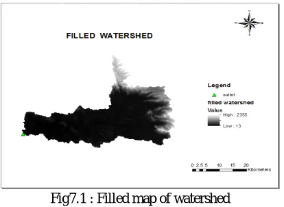
The first step to be done in the delineation of watershed is ‘fill’. The tool fill in a surface raster is to remove small imperfections in the data. The result of this step will be a depression less DEM which will in turn be the basis of the rest of the process.
Fig7.1 : Filled map of watershed
. ‘Flow direction’ is done to compute the direction of flow out of each cell. This tool takes a filled surface as input and outputs a raster showing the direction of flow out of each cell.
Fig 7.2 :Flow direction of watershed
Fig 7.3 :Flow accumulationwatershed
The Thuthapuzhawatershed was delineated using Thiruvegappura discharge station as the outlet point. The delineated watershed is shown in fig 7.4
Fig 7.4: Delineated watershed
(B).Development of unit hydrograph using CWC method
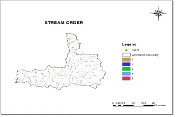
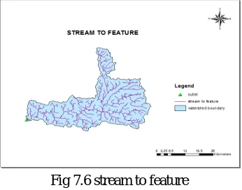
From the delineated watershed, the UH parameters which are required for the development of unit hydrograph were calculated using the CWC formulae. The stream order obtained and stream to feature function done for converting the stream from raster to vector format are shown in fig 7.5 and fig 7.6 respectively. The longest stream identified and the number of points considered for the determination of bed level is shown in fig 7.7.
The tool ‘Stream to feature’ converts a raster representing a linear network to features representing the linear network. The input stream raster linear network should be represented as values greater than or equal to one on a background of No Data.
Fig 7.6 stream to feature
The longest stream was identified from the stream to feature data. 540 points (multi-point shapefile) were taken along the longest stream, where the bed level changes considerably.
Fig. 7.7 Identification of longest stream and points considered for computing equivalent slope
The parameters that were computed using the CWC formulae for the development of the UH are shown in the table below.
Table 7.1 Parameters estimated by CWC method
Parameter Value obtained
Area of watershed (A) 985 sq.km.
Length of longest stream (L) 86.693 km
Equivalent stream slope (S) 59.09 m/km
Peak discharge (qp) 0.778 m3/s/km2
Time to peak discharge (tp) 2.05 hours
Base width of UH (TB) 12.50 hours
W50 2.53 hours
W75 1.324 hours
WR50 0.764 hours
WR75 0.452 hours
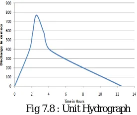
The UH developed for the Thuthapuzha river basin using Thiruvengapura as discharge station is shown in fig 6.8below,
Fig 7.8 : Unit Hydrograph
Total discharge (Qp) was obtained as 766.33 cumecs. The values of base width of UH (TB) and time to peak discharge (Tp) are obtained as 12.50 hours and 2.55 hours respectively. Area under the unit hydrograph was calculated and it is obtained as 1.23 centimeter which is approximately equal to unity. Hence the result is close enough to be right.
VIII.CONCLUSION
Central Water Commission (CWC) method was effective in developing the unit hydrographs for the Thuthapuzha river basin. The depth of rainfall obtained by using the area under the unit hydrograph was 1.23 centimeters, which is close to unity. Moreover GIS was found to be efficient and effective software for determining the physical characteristics of the watershed. Hence by using the physical characteristics of the watershed and then determining various parameters for computing the unit hydrograph by the CWC method, we can conclude that such a method could be efficiently applied for ungauged stations.
REFERENCES
[1] Abhinanda Roy and ReebaThomas: ”Development of Spatially Distributed Unit Hydrograph For Bharathapuzha River Basin”, International Journal of Innovative Research in Science, Engineering and Technology, Vol. 6,Special Issue 4, March2017
[2] Abhinanda Roy and ReebaThomas: ”A Comparative Study On The Derivation Of Unit Hydrograph For Bharathapuzha River Basin”, Elsivier Procedia Technology, Vol. 24, pp. 62–69, 2016
[3] Brunda G.S, Pramod N.P, Sharathchand U.B, “Derivation of Unit Hydrograph and S Curve for Haridra river catchment using CWC method Method”, International Journal of Scientific Development and Research(2455 – 2631), Volume 1, No.6, pp. 439-443, 2016
[4] Jayantilal n. Patel and akshay r. Thorvat: “Synthetic Unit Hydrograph Development for Ungauged Basins Using Dimensional Analysis”, American Water Works Association, March.,2016.
[5] Purabi Deka1, Mrinmoy Kr. Gautam, “Derivation of Unit Hydrograph From GIS Based GIUH” International Journal of Interdisciplinary Research (2454 – 1362), Volume 2, No.8, pp.555-562, 2016
[6] Devi, Tapasranjn Das, “Derivation of Synthetic Unit Hydrograph for Ranganadi Basin and Dikrong river Basin in Assam-Arunachal”, International Journal of Innovative Research in Science and Engineering (2454 – 9665), Volume 2, No.4, pp.145-153, 2016
[7] Brunda G S and Shivakumar J Nyamathi: “Derivation and Analysis of Dimensionless Hydrograph and S Curve for Cumulative Watershed Area”, International Conference on Water Resources, Coastal and Ocean ,pp. 964-971, 2015
[8] Ayser Mohammed Al-Shamma:“Stream Network Delineation and Watershed Segmentation Of Wadi Al-Khur Basin in the South of Iraq by Using the (GIS)” ,International Journal of Environment & Water,2015.
[9] Lalitesh Sinha, Rupesh Rathore, and Utkarsh Jain, “Watershed Delineation of Narmada Basin- Indira Sagar Dam to Maheshwar Dam of M adya pradesh” International Journal of Emerging Technology and Advanced Engineering (2250 – 2459), Volume 5, No.8, pp.307-312, 2015 [10] Rasheed Saleem Abed, “Watershed delineation in GIS environment”, International Journal of Enhanced Research in Science, Technology and
Engineering (2319 – 7463), Volume 2, No.5, pp.48-54, 2013
[11] R. Patil et.al : “Two-parameter gamma-based SUH derivation”, International Journal of Environmental Science and Development, vol. 3, no. 5, October,2012