Hydrol. Earth Syst. Sci., 17, 2929–2946, 2013 www.hydrol-earth-syst-sci.net/17/2929/2013/ doi:10.5194/hess-17-2929-2013
© Author(s) 2013. CC Attribution 3.0 License.
EGU Journal Logos (RGB)
Advances in
Geosciences
Open Access
Natural Hazards
and Earth System
Sciences
Open AccessAnnales
Geophysicae
Open AccessNonlinear Processes
in Geophysics
Open AccessAtmospheric
Chemistry
and Physics
Open AccessAtmospheric
Chemistry
and Physics
Open Access DiscussionsAtmospheric
Measurement
Techniques
Open AccessAtmospheric
Measurement
Techniques
Open Access DiscussionsBiogeosciences
Open Access Open Access
Biogeosciences
DiscussionsClimate
of the Past
Open Access Open Access
Climate
of the Past
Discussions
Earth System
Dynamics
Open Access Open Access
Earth System
Dynamics
DiscussionsGeoscientific
Instrumentation
Methods and
Data Systems
Open Access
Geoscientific
Instrumentation
Methods and
Data Systems
Open Access DiscussionsGeoscientific
Model Development
Open Access Open Access
Geoscientific
Model Development
DiscussionsHydrology and
Earth System
Sciences
Open AccessHydrology and
Earth System
Sciences
Open Access DiscussionsOcean Science
Open Access Open Access
Ocean Science
Discussions
Solid Earth
Open Access Open Access
Solid Earth
Discussions
The Cryosphere
Open Access Open Access
The Cryosphere
DiscussionsNatural Hazards
and Earth System
Sciences
Open Access
Discussions
Assimilating in situ and radar altimetry data into a large-scale
hydrologic-hydrodynamic model for streamflow forecast in the
Amazon
R. C. D. Paiva1,2, W. Collischonn1, M.-P. Bonnet2, L. G. G. de Gonc¸alves3, S. Calmant4, A. Getirana5, and J. Santos da Silva6
1Instituto de Pesquisas Hidr´aulicas IPH, Universidade Federal do Rio Grande do Sul UFRGS, Brazil
2G´eosciences Environnement Toulouse GET, UMR5563, CNRS IRD UPS – OMP, Universit´e Toulouse III Paul Sabatier,
Toulouse, France
3CPTEC/INPE - Centro de Previs˜ao de Tempo e Estudos Clim´aticos, Instituto Nacional de Pesquisas Espaciais,
Cachoeira Paulista, Brazil
4Laboratoire d’Etudes en G´eophysique et Oc´eanographie Spatiales LEGOS (UMR 5566 CNES CNRS IRD UPS), OMP,
Universit´e Toulouse III Paul Sabatier, Toulouse, France
5NASA Goddard Space Flight Center, Hydrological Sciences Lab,Greenbelt, USA 6Universidade do Estado do Amazonas UEA, Brazil
Correspondence to: R. C. D. Paiva ([email protected])
Received: 1 February 2013 – Published in Hydrol. Earth Syst. Sci. Discuss.: 7 March 2013 Revised: 30 May 2013 – Accepted: 17 June 2013 – Published: 24 July 2013
Abstract. In this work, we introduce and evaluate a data
assimilation framework for gauged and radar altimetry-based discharge and water levels applied to a large scale hydrologic-hydrodynamic model for stream flow forecasts over the Amazon River basin. We used the process-based hydrological model called MGB-IPH coupled with a river hydrodynamic module using a storage model for flood-plains. The Ensemble Kalman Filter technique was used to assimilate information from hundreds of gauging and al-timetry stations based on ENVISAT satellite data. Model state variables errors were generated by corrupting precip-itation forcing, considering log-normally distributed, time and spatially correlated errors. The EnKF performed well when assimilating in situ discharge, by improving model estimates at the assimilation sites (change in root-mean-squared error1rms =−49 %) and also transferring informa-tion to ungauged rivers reaches (1rms =−16 %). Altimetry data assimilation improves results, in terms of water levels (1rms =−44 %) and discharges (1rms =−15 %) to a minor degree, mostly close to altimetry sites and at a daily basis, even though radar altimetry data has a low temporal res-olution. Sensitivity tests highlighted the importance of the
1 Introduction
Land surface waters play an important role in global wa-ter cycle and earth system, regulating freshwawa-ter discharge from land into oceans (Oki and Kanae, 2006) and also land-atmosphere exchanges of water, energy (Krinner, 2003; Decharme et al., 2011) and gases such as methane (Gedney et al., 2004). Moreover, it directly affects society that uses it for drinking water and also transportation of people and goods, agriculture and energy production from hydropower. More specific to the Amazon basin, important extreme hydrologi-cal events have occurred recently, for instance, the 2009 and 2012 floods and the 1996, 2005 and 2010 droughts (Chen et al., 2010; Tomasella et al., 2010; Marengo et al., 2008, 2011; Espinoza et al., 2011). These events caused several impacts on local population that strongly depends on the rivers and is very vulnerable to floods since most settlements lie along the rivers.
In situ measurements of river stage and discharge at stream gauges are the most conventional alternative for monitor-ing surface waters, although observation networks are rather sparse at several regions such as the Amazon River basin. Al-ternatively, radar altimetry techniques have been developed in past years to monitor water levels (e.g. Santos da Silva et al., 2010; Alsdorf et al., 2007) or discharges using rating curves (e.g. Leon et al., 2006; Papa et al., 2010a; Getirana and Peters-Lidard, 2013). If compared to in situ gauges in remote regions, these satellite instruments can provide ob-servations with much better spatial coverage, but with worse temporal sampling. Moreover, the forthcoming Surface Wa-ter and Ocean Topography (SWOT) mission (Durand et al., 2010a) is designed to provide high resolution images of in-land water surface elevation, including rivers, lakes, wetin-lands and reservoirs, using a swath mapping radar altimeter with high frequency repeat orbit. Additionally, it may also be pos-sible to derive discharge estimates from SWOT data by using specially developed algorithms (e.g. Durand et al., 2010b).
In contrast, there are several efforts on hydrological mod-elling to simulate processes as river and floodplain dynamics in large river basins such as the Amazon (Paiva et al., 2013a, b; Yamazaki et al., 2011; Getirana et al., 2012; Decharme et al., 2011; Coe et al., 2008; Wilson et al., 2007; Trigg et al., 2009). These models can potentially provide detailed infor-mation on surface waters, both spatially and temporally, but such estimates are somehow imperfect due to uncertainty in model structure, parameters and forcing data (Liu and Gupta, 2007).
Data assimilation (DA) methods are an alternative to op-timally merge uncertain model predictions with both in situ and the newly remote-sensing observations of surface waters. The aim of DA techniques is to “produce physically consis-tent representations or estimates of the dynamical behaviour of a system by merging the information present in imper-fect models and uncertain data in an optimal way to achieve uncertainty quantification and reduction” (Liu and Gupta,
2007). Such methods can also be used to estimate balanced initial states of hydrological models for forecasting the afore-mentioned extreme events. There are already some hydrolog-ical regional/global forecast systems founded on physhydrolog-ically- physically-based hydrological models (e.g. Wood et al., 2002; Thielen et al., 2009; Alfieri et al., 2013), and also several physical modelling experiments in the Amazon basin, as previously mentioned. However, current attempts for developing hydro-logical forecasts in this particular basin are mostly based on statistical methods (e.g. Uvo and Grahan, 1998; Uvo et al., 2000). Furthermore, Paiva et al. (2012) showed that, for lead times up to 3 months, uncertainty of initial conditions plays a major role for discharge predictability on main Amazonian Rivers, if compared to the importance of precipitation forc-ing, suggesting the importance of DA techniques for stream-flow forecasts in this region.
Although there is an extensive bibliography on hydrological data assimilation, the current state of the art regional/global hydrological prediction systems (e.g. Thielen et al., 2009; Alfieri et al., 2013) still do not incorporate advanced data as-similation systems for updating model initial states. Also, the assimilation of discharge and water levels from in situ and re-motely sensed observations into regional/global hydrologic-hydrodynamic models is still uncommon.
In this paper, we present the development and evaluation of a data assimilation framework for both gauged and radar altimetry-based discharge and water levels into a large scale hydrologic-hydrodynamic model of the Amazon River basin using the EnKF. We also explore the usefulness of such sys-tem to provide streamflow forecasts when forced by past re-motely sensed precipitation data and based mostly on model initial conditions. This paper is in the context of recent de-velopments of techniques for integrating information from hydrological models with newly remotely sensed data such as the forthcoming SWOT mission and also in the context of regional/global hydrological forecast systems including large, poorly gauged river basins. Through our experimen-tal results, we explore questions such as: is an EnKF-based DA scheme feasible for assimilating discharge and water level data into large scale hydrologic-hydrodynamic mod-els? Is it able to improve discharge and water level estimates at sites where data were assimilated and also at ungauged rivers? Does the assimilation of radar altimetry data also im-prove model estimates at large river basins, considering that it has lower temporal resolution and accuracy if compared to gauged in situ data? Would it be possible to provide accu-rate streamflow forecasts at large basins such as the Amazon using a large scale hydrologic-hydrodynamic model based mostly on the initial hydrological states gathered by the DA scheme? At which spatial and temporal scales?
2 Methods
2.1 The hydrologic-hydrodynamic model
We used the MGB-IPH model (Collischonn et al., 2007), which is a large scale, distributed and process-based hy-drological model with a hydrodynamic module described in Paiva et al. (2011). It simulates surface energy and water bal-ance and also discharge, water level and flood inundation on a complex river network. Vertical hydrological processes in-clude soil water budget using a bucket model, energy budget and evapotranspiration using the Penman Monteith approach, and also surface, subsurface and groundwater flow genera-tion, among others. The flow generated within each catch-ment is routed to the stream network using a linear reservoir type model. River flow routing is performed using a com-bination of either a Muskingum-Cunge (MC) method or a hydrodynamic model (HD).
The hydrodynamic model of MGB-IPH (Paiva et al., 2011) solves the full 1-D Saint-Venant equations for the river net-work and flood inundation is simulated using a simple model assuming that the floodplains act only as storage areas. River-floodplain parameters (river width, bottom levels, roughness coefficient, floodplain bathymetry) are estimated using GIS-based algorithms from the Shuttle Radar Topography Mis-sion (SRTM) Digital Elevation Model (DEM) (Farr et al., 2007) and using geomorphological relations.
2.2 The Ensemble Kalman Filter
The goal of data assimilation is to combine the uncertain and complementary information from measurements and simu-lation models into an optimal estimate of the hydrological fields of interest, providing a general framework for dealing with uncertainty from measurements and also from model inputs, structure and outputs (Reichle, 2008; Liu and Gupta, 2007; Liu et al., 2012; Vrugt et al., 2005).
A great part of the hydrological applications of data as-similation methods uses schemes based on the Kalman fil-ter (Kalman, 1960), specially the Ensemble Kalman Filfil-ter (Evensen, 2003, 2009), which is also used in this study and is briefly described below. The model representing the dy-namics of the simulated system can be shown in a discrete form by the process equation:
xk+1=M (xk,uk,θ)+qk (1)
wherexrepresents the state variables and,uandθrepresent model forcings and parameters respectively,Mis the nonlin-ear model operator that relates model states from time inter-valtk totk+1=tk+1t, andqk represents errors in model structure, parameter, forcings and antecedent states. In this study, x is a vector composed by all MGB-IPH state vari-ables, i.e. soil moisture, storage and discharge from sur-face, subsurface and groundwater reservoirs, soil tempera-ture, canopy storage and river discharge and water level. The measurement equation is defined by:
yk=H (xk)+εk (2)
whereyis observation vector,εis the vector of observation errors and H is the observation operator which relates the model state variables vectorx to the observations vectory. In our case, observations are river discharges or water levels at selected sites.
In the context of forecast systems and sequential data as-similation methods, at each time interval, the model is in-tegrated in time using Eq. (1) to provide a short-term fore-cast (or background)xfk+1and whenever an observation is available, the forecast errors (called model innovations) are computed as (yk+1–H(xfk+1)). Therefore, the goal of data
1960), the DA problem is solved using a linear estimator as-suming that (i) model and observation operators (MandH ) are linear; (ii) observation errors are unbiased and both tem-porally and spatially uncorrelated; (iii) model errors are unbi-ased and temporally uncorrelated; and (iv) there is no corre-lation between model and observation errors. Consequently, an unbiased and minimum variance estimate of model states is obtained by:
xa=xf+Ky−Hxf (3)
K=PfHThHPfHT+R
i−1
(4) where K is the Kalman gain, P is the covariance of model er-rorsq, and R is the covariance of measurement errorsε. The Kalman filter also provides the maximum likelihood solu-tion of the DA problem when model and measurement errors are assumed to be also Gaussian. However, the applicability of the KF is limited since most hydrological systems exhibit nonlinear dynamics (Liu and Gupta, 2007) and the assump-tions about model errors (e.g. Gaussian, unbiased, among others) are not always valid. Moreover, both the original KF and also its nonlinear version, the Extended KF (EKF), have additional drawbacks when applied in large and complex sys-tems with lots of state variables (e.g. distributed hydrological models) due to extra programming and heavy computational requirements associated with the storage and forward inte-gration of the error covariance matrix P (Vrugt et al., 2005). Evensen (2003) presented the Ensemble Kalman Filter (EnKF), which is a stochastic or Monte Carlo alternative for the deterministic EKF (Evensen, 2009). In this method, en-sembles of model states and/or observations are generated using a priori-known errors and by means of the model op-eratorM, the algorithm generates an ensemble of model tra-jectories from which the time evolution of model errors and error covariance matrix can be sampled:
Pf∼=Pfe=
xf−xf xf−xfT,
Pa∼=Pae= xa−xa
xa−xaT. (5)
Each ensemble member is then updated using the same anal-ysis equation from the original KF (Eqs. 3 and 4). Alterna-tively, efficient computational implementations of the EnKF are presented in Evensen (2003, 2004 and 2009) (see http: //enkf.nersc.no/ for Fortran codes) where the explicit compu-tation and storage of Pfare not required. We used the square root scheme presented in Evensen (2004, 2009) where the perturbation of measurements is not performed, in order to reduce sampling errors.
For linear systems and with large ensemble sizes, the EnKF provides the same solution as the KF method. How-ever, it is noteworthy that it does not fully take into account non-Gaussian errors nor solve the Bayesian update equation for non-Gaussian probability distribution functions. Still, it is
a computational efficient analysis scheme for nonlinear mod-els that provides a satisfactory solution, although it is subop-timal, that somehow lies between a linear Gaussian update and a full Bayesian computation (Evensen, 2009). Also, the advantage of the EnKF is that it can be easily implemented in any mathematical model, e.g. it does not require the devel-opment of a particular adjoint model as the variational meth-ods, and it usually requires smaller ensemble sizes, and con-sequently less computational effort, if compared to particle filter methods (Liu et al., 2012).
2.3 Uncertainty in precipitation forcing
We perturbed model states variables by adding a noise in pre-cipitation forcing, considering (i) that this is the most un-certain model input (Liu et al., 2012) and possibly the most important source of model uncertainty and (ii) that this is a proper method to generate physically coherent model errors. A similar approach performed satisfactorily in other hydro-logical applications of DA methods such as Andreadis and Lettenmaier (2006) and Biancamaria et al. (2011). Precipita-tion values were corrupted using a log-normally distribuPrecipita-tion as presented by Nijjsen and Lettenmaier (2004) and also ap-plied by Andreadis and Lettenmaier (2006):
Pc=√1+β E2+1exp
q
lnE2+1 s
P (6)
wherePc [mm1t−1] is the perturbed daily precipitation,P [mm1t−1] is the unperturbed daily precipitation,E is the
relative error [%], β is the relative bias and s∼N(0,1) is a normally distributed and spatially correlated random vari-able with zero mean and unit variance. Spatially correlated pseudo random fieldswwere generated by means of the al-gorithm based on the two dimensional Fourier transform pre-sented in Evensen (2003) (see http://enkf.nersc.no/ for For-tran codes), having zero mean, unit variance and isotropic covariance function decreasing to thee−1 value at the dis-tanceτx called spatial decorrelation length. At each spatial
location, temporal correlation was also considered using the following equation for simulating the time evolution of errors (Evensen, 2003):
sk=αsk−1+
p
1−α2wk−1 (7)
wherek is the time interval,sk is a sequence of time cor-related errors with zero mean and unit variance (input for Eq. 6) andαdetermines the time decorrelation of the stochas-tic forcing, e.g.α=0 generates a sequence of white noise whileα=1 removes the stochastic forcing. The parameterα is determined by:
α=1−1t τt
(8) whereτtis the temporal decorrelation length, that determines
thatsdecreases by the ratioe−1after a time periodt=τtif
2.4 Measurement errors
Water level (z) and discharge (Q)observations errors were modelled using the following relations:
zc=z+εz, εz∼N
0, σz2 (9)
Qc=Q+εQ, εQ∼N
0, σQQ 2
(10) wherezc[m] andQc [m3s−1] are the observations ofz[m] andQ[m3s−1],εz[m] andεQ[m3s−1] are the normally dis-tributed errors with parametersσz[m] andσQ[%] ofzand Q, respectively. The formulation of discharge errors allows representing larger uncertainties for high stage levels than for low flows due to uncertainties in discharge rating curves, as pointed out by Clark et al. (2008). Alternatively, simulated and observed discharges were also transformed into the log space before the assimilation, following Clark et al. (2008). In this case, observation errors were modelled by:
Qc=ε0QQ, ε0Q∼logN
1, σ02Q
(11) where nowε0Qis a log-normally distributed error with unit mean and standard deviationσ0Q [%], similar to Eq. (10). At log space, standard deviation is given by σ0logQ= r
logσ02
Q+1
.
3 Experimental design
3.1 The Amazon River basin
The study area is the Amazon River basin, known as the largest hydrological system of the world (∼6 million km2 of surface area) and contributing with∼15 % to the total fresh water released into the oceans. The Amazon basin is characterised by extensive seasonally flooded areas (Hess et al., 2003; Papa et al., 2010b; Melack and Hess, 2010), which store and release large amounts of water from the rivers and consequently attenuate and delay flood waves in several days or months (Paiva et al., 2013a, b; Yamazaki et al., 2011). Also, complex river hydraulics are present, where the low river slopes cause backwater effects that control part of river dynamics (Meade, 1991; Trigg et al., 2009; Tomasella et al., 2010; Paiva et al., 2013a, b). Additionally, this region presents high precipitation rates (average∼2200 mm yr−1) with high spatial variability and contrasting rainfall regimes in the northern (rainfall peak at JJA) and southern (rain-fall peak at DJF) parts of the basin, with more defined wet and dry seasons occurring in southern and eastern regions (Espinoza et al., 2009).
3.2 Model implementation
We used a MGB-IPH implementation on the Amazon basin developed by Paiva et al. (2013b), as briefly described be-low. The model was forced using meteorological data ob-tained from the CRU CL 2.0 dataset (New et al., 2002) and remotely sensed precipitation estimates from the TRMM 3B42 v6 product (Huffman et al., 2007), with spatial res-olution of 0.25◦×0.25◦ and daily time step for a period spanning 12 yr (1998–2009). The model parameters related to soil water budget were calibrated using daily discharge data from stream gauges (see next section for description of gauged data). Then, the model was validated against daily discharge and water level data from stream gauge stations, water levels derived from ENVISAT satellite altimetry data (Santos da Silva et al., 2010) (212 sites with 35-day repeat orbit), monthly Terrestrial Water Storage from GRACE mis-sion (Frappart et al., 2010, 2011) and monthly flood inun-dation extent from Papa et al. (2010b). Simulations agreed with observations, with relatively high Nash and Suttcliffe in-dex (ENS)values:ENS>0.6 in∼70 % of discharge gauges,
ENS>0.6 in ∼60 % of the water level stations derived
from satellite altimetry,ENS=0.71 for total flood extent and
ENS=0.93 for terrestrial water storage.
Since this study aimed at applications of data assimilation to hydrological forecasting, we also used a real time precip-itation product to force the MGB-IPH model. We choose to use the TRMM Merge product (Rozante et al., 2010), which is a near to real time precipitation estimate based on TRMM 3B42RT (Huffman et al., 2007) merged with data from in situ gauges and provided by the Brazilian centre for weather forecasts and climate studies CPTEC (Centro de Previs˜ao do Tempo e Estudos Clim´aticos), a division of the Brazilian Na-tional Institute for Space Research INPE (Instituto Nacional de Pesquisas Espaciais).
3.3 Discharge and water level observations
We evaluated the assimilation of three types of data: (1) in situ discharge observations; (2) remotely sensed water levels derived from the ENVISAT radar altimeter; and (3) remotely sensed discharge estimates derived from radar altimetry wa-ter levels and rating curves.
In situ daily discharge from 109 stream gauges were pro-vided by the Brazilian agency for water resources ANA (Agˆencia Nacional das ´Aguas), the Peruvian and Bolivian national meteorology and hydrology services SENAMHI (Servicio Nacional de Meteorolog´ıa e Hidrolog´ıa) and the French ORE-HYBAM programme (Hydrologie, Bio-geochimie and Geodynamique du Bassin Amazonien, http: //www.ore-hybam.org). We also used stage data from 66 ANA gauge stations, but only for validation purposes.
Equator. The database used is an extension of the one pre-sented in Santos da Silva et al. (2010), consisting in 212 altimetry stations (AS – deduced from the intersection of a satellite track with a water body) with water level time se-ries for the 2002–2009 period. ENVISAT data selection tech-niques preconized by Santos da Silva et al. (2010) result in ∼10 to 40 cm water level accuracy. Due to differences in water levels datum reference, the comparisons between sim-ulated and observed water levels were performed in terms of anomalies, i.e. after removing the long-term average.
Altimetry-based discharge data was developed by Getirana and Peters-Lidard (2013) for the Amazon basin. This dataset was constructed using a rating-curve-based methodology de-riving water discharge from ENVISAT altimetry data at 475 altimetric stations. The stage-discharge relations at each AS were built based on satellite altimetry and outputs from a global flow routing (GFR) scheme (Getirana et al., 2012). A second experiment was performed by Getirana and Peters-Lidard (2013) using observed discharges at gauge stations to force the GFR scheme at downstream reaches. Validation of the methodology against observed discharges at 90 sites showed a mean relative error of 27 % for the experiment us-ing in situ discharge within the GFR scheme. We assimilated data only from the 287 ASs located downstream of a gaug-ing station where the accuracy of discharge estimates from Getirana and Peters-Lidard (2013) was generally better.
3.4 Parameters of the DA scheme
The first sensitivity experiments used the following standard parameters of the DA scheme. Ensemble size of the EnKF was set asN=200. Precipitation fields were corrupted con-sidering the following error parameters: precipitation relative errorE= 25 %, and precipitation relative biasβ= 1.0 follow-ing Andreadis and Lettenmaier (2006); temporal decorrela-tion length of precipitadecorrela-tion errors τt=10 days; and spatial
decorrelation length of precipitation errors τx=1.0◦,
sim-ilarly to Andreadis and Lettenmaier (2006) and Clark et al. (2008). The parameter of water level measurements er-ror was set as σz= 0.20 m, based on the accuracy of EN-VISAT estimates provided by Santos da Silva et al. (2010). We computed the mean relative error between in situ dis-charge measurements and values provided by rating curves at 87 gauging stations from the ANA database as a surrogate of the discharge error parameterσQ. The median value of all stations was 13 %, while Clark et al. (2008) used 10 % in its DA experiments. Therefore, we choose to also useσQ= 10 % for simplicity. We usedσQ=27 % for assimilation of satel-lite based discharge data, based on the error value found in Getirana and Peters-Lidard (2013).
3.5 Data assimilation experiments
We performed three data assimilation experiments, namely: (i) in situ discharge assimilation (Exp 1) (ii) Radar
altimetry assimilation (Exp 2) and (iii) Assimilation of discharge series based on satellite altimetry (Exp 3).
In the first experiment, we tested: (Exp. 1a) the assim-ilation of discharge from almost all gauge stations (80 %) using a few of them for validation (20 %), where these sta-tions where randomly chosen; (Exp. 1b) the assimilation of only 12 stations (∼10 %) located at some of the major tribu-taries to emulate the situation of using only telemetric stream gauges for real time applications – we choose 1 or 2 stations located at the downstream reach of the largest Amazonian rivers; (Exp. 1c) the assimilation of discharge from almost all gauge stations, similar to (Exp. 1a), but without trans-forming discharge into the log space (Sect. 2.4.). Moreover, we explored the sensitivity of the DA scheme to some of its parameters, namely the ensemble sizeN, precipitation rela-tive errorEand temporal and spatial decorrelation lengths of precipitation errorsτt, andτx.
The second experiment (Exp. 2) evaluated the assimilation of ENVISAT radar altimetry water level anomalies from all altimetry stations. Stage data from all in situ gauges were used for model verification. Simulations were also compared in terms of discharge using in situ data to evaluate the impact of water level assimilation in discharge estimates.
In the third experiment (Exp. 3), we assessed the assimila-tion of discharge derived from radar altimetry water level at all altimetry stations. Discharge data from all stream gauges were used for verification.
In all cases, simulations started in 1998 and ran to 2002 for model spin-up. The year of 2003 was used for the spin-up of the DA scheme, where no update was performed in the first months allowing the system to develop a coherent correlation structure, following Andreadis and Lettenmaier (2006). To access the DA scheme performance, model simulations us-ing (EnKF simulation) and not usus-ing (Open-loop simulation) data assimilation were compared. Results were evaluated for the two year period 2004–2005 by means of the following model performance statistics that compare simulation results with observations: (i) the Nash-Suttcliffe coefficient ENS
ranging from−∞to 1 (optimum) and (ii) changes in root-mean-square error 1rms=100 (rms2–rms1)/rms1, ranging
from −100 % (optimum) to ∞, where rms1 and rms2 are
root-mean-squared errors from Open-loop and EnKF simu-lations, respectively. The period 2004–2005 was chosen for its highest availability of in situ discharge and stage data to-gether with altimetry data, and also because it contains an important extreme hydrological event – the 2005 drought.
3.6 Prospects of streamflow forecasting
the spin-up period using a hydrological model driven by ob-served meteorological forcings, updated using data assimi-lation of observations up to the time of forecast (e.g. fore-cast starts with model states from 1 June of 2010). Then, an ensemble forecast is obtained using observed meteorologi-cal data resampled from past years (e.g. meteorologimeteorologi-cal data from 1 June to 1 September of years 1998, 1999,. . . , 2009).
Precipitation from TRMM Merge was used during spin-up period, while during forecast the model was forced with TRMM 3B42 data for the period spanning 12 years (1998– 2009) and, consequently, the forecast ensemble had 12 mem-bers. The DA scheme used the configuration from Exp. 1b where in situ discharge data were assimilated to update model states before starting a forecast. ESP runs generated decadal forecasts up to 90 days lead time and starting at every 1st, 10th and 20th day of the month for the two year period of 2004–2005. Aiming at exploring the usefulness of such sys-tem to provide streamflow forecasts in future applications, we chose to test it for a past period (2004–2005) where a large amount of discharge data is available for verification. For simplicity reasons, forecasts were evaluated only by de-terministic means by averaging ensemble values into a single forecast. We used the skill score SScli which compares the
performance of the model forecasts with a control forecast based on climatology (Wilks, 2006):
SScli=1−
P
t
(Qtobs−Qtfor)2
P
t
(Qtobs−Qtcli)2 (12)
wheretis the time interval,Qobsis daily discharge observed
at stream gauge stations,Qforis forecasted discharge,Qcliis
the climatological value of discharge on daytcomputed from observations. SScliranges from−∞to 1 (optimum) and
pos-itive values show an improvement over a forecast based on climatology.
4 Results and discussion
4.1 In situ discharge assimilation
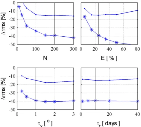
[image:7.595.310.546.62.275.2]We start our analysis evaluating the sensitivity of the DA scheme performance to some of its parameters, as presented in Fig. 1. The objective of such examination is to verify which parameters are the most important ones and if the DA performance is improved by using values of these parame-ters that are different from the first guess ones based on pre-vious studies (see Sect. 3.4.). The configuration of Exp. 1a was used, where in situ discharge data were assimilated. Re-sults were evaluated in terms of mean changes in root-mean-squared error (1rms) between observed and simulated dis-charges, computed for two samples, the first including stream gauges used for data assimilation and the latter only the vali-dation ones. Larger decreases in the rms error indicate better performance of the DA scheme.
Fig. 1. Sensitivity tests of DA scheme parameters. Mean change in root-mean-square error (1rms) for the assimilation (line with stars) and validation (line with dots) stream gauges as function of ensemble size (N ), precipitation relative error (E)and spatial (τx)
and temporal (τt)decorrelation lengths of precipitation errors. First
guess values are represented by the black line.
According to the analysis, the DA scheme strongly de-pends on the ensemble size N. Small N values produce small improvements in discharge results and larger values enhance the DA performance (smaller 1rms values), al-though the improvement rate is small for N values larger than 150 members. Such behaviour is possibly due to nu-merical reasons, since a largerN enable a better sampling of model covariance errors from the ensemble, as discussed by Evensen (2009). The DA scheme is also very sensitive to pre-cipitation relative errorEand increasingEvalues improves DA performance. However, ifEis larger than 50 %,1rms in-creases in validation sites causing worse results (see Fig. 1). Possibly, larger precipitation errors cause larger model uncer-tainty and consequently the DA scheme gives more weight to observations, but it starts to degrade model results at different locations after some point. A moderate dependence to theτx
parameter was found and spatial correlation of precipitation errors showed to be of importance, since the performance degrades for smaller decorrelation lengths. The best results were obtained for 1.5◦for both the assimilation and valida-tion samples. Finally, a weak sensitivity to theτt parameter
was found, which indicates that considering temporal cor-relation in precipitation errors is not as important as spatial correlation.
Based on the sensitivity tests, we used the following new parameter values for the further experiments:N=200 (un-changed),E= 50 %,τx=1.5◦andτt=10 days (unchanged).
Fig. 2. Evaluation of in situ discharge assimilation. Spatial distribution of change in root-mean-square error (1rms) in stream gauges used for data assimilation (circles) and validation (squares) considering the assimilation of (a) almost all gauges (Exp. 1a), (b) only 12 gauges (Exp. 1b) and (c) almost all gauges but without log transformation (Exp. 1c).
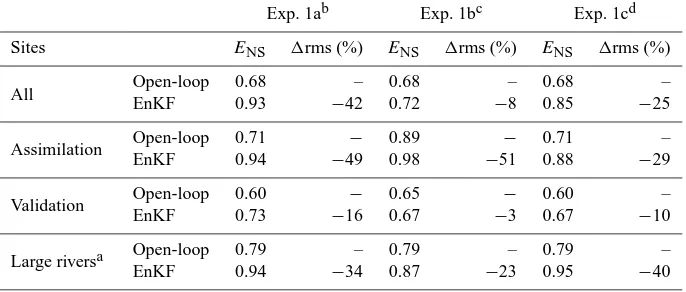
Table 1. Summary of the performance of in situ discharge data assimilation (Exp. 1): median Nash and Suttcliffe index (ENS)in simulation (Open-loop) and assimilation (EnKF) modes and mean change in root-mean-square error (1rms).
Exp. 1ab Exp. 1bc Exp. 1cd
Sites ENS 1rms (%) ENS 1rms (%) ENS 1rms (%)
All Open-loop 0.68 – 0.68 – 0.68 –
EnKF 0.93 −42 0.72 −8 0.85 −25
Assimilation Open-loop 0.71 − 0.89 − 0.71 –
EnKF 0.94 −49 0.98 −51 0.88 −29
Validation Open-loop 0.60 − 0.65 − 0.60 –
EnKF 0.73 −16 0.67 −3 0.67 −10
Large riversa Open-loop 0.79 – 0.79 – 0.79 –
EnKF 0.94 −34 0.87 −23 0.95 −40
aStream gauges located at rivers reaches with upstream drainage area larger than 105km2.bExp. 1a – data assimilation using discharge from 80 % of the stream gauges.cExp. 1b – data assimilation using discharge from 10 % of the stream gauges.dExp. 1c – equal Exp. 1a but without transforming discharge into the log space.
to precipitation errors, although providing better results for data assimilation, may not realistically represent errors in the TRMM Merge dataset. For example, Tian and Peters-Lidard (2010) developed a global map of errors in daily satellite-based precipitation estimates that show features not represented here: errors that are spatially and seasonally vari-able and that decrease with precipitation rate (from∼100 % at 1 mm d−1to∼20 % at 100 mm d−1in South America). On the other hand, the DA scheme had better performance with E= 50 %, which is only slightly larger than the values found by Tian and Peters-Lidard (2010) for the Amazon region, that ranges from∼20 % to∼70 %. A possible explanation is the consideration of that model uncertainty coming from precip-itation errors and neglecting other sources such as parameter and model structural errors (Liu and Gupta, 2007), making Elarger. Therefore, and since the first guess values were not fully justified in the previous studies (Andreadis and
Letten-maier, 2006; Clark et al., 2008), we preferred to use the pa-rameter values where the DA scheme performs better.
We first evaluate results from the Exp. 1a. The DA scheme improves results by decreasing model errors in almost all stream gauges (blue sites in Fig. 2a), including both assimi-lation and validation sites. On average,ENSvalues increase
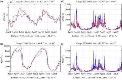
from 0.71 to 0.94 and the rms error decreases by 49 % (Ta-ble 1). For example, at an assimilation site located on the Negro River (Fig. 3a), when the EnKF is used, the discharge estimates are much closer to observations if compared with the open-loop simulation. The ENS index increases from
0.62 to 0.91 and the rms error decreases by 51 %. Simi-larly, results also improve at validation sites, although with a smaller degree, and theENSindex increases from 0.60 to
[image:8.595.127.470.296.442.2]Fig. 3. Discharge derived from in situ observation (blue line), open-loop simulation (black line) and EnKF simulation (red line) at (a) Negro River (assimilation site, Exp. 1a), (b) upper Juru´a River (validation site, Exp. 1a), (c) lower Juru´a River (validation site Exp. 1b) and upper Juru´a River (assimilation site, Exp. 1c). Site are indicated Fig. 2.
data were assimilated but possibly at ungauged rivers reaches as well.
In Exp. 1b, results improve at assimilation sites – ENS
increases from 0.89 to 0.98 and the rms error decreases by 50 % (Table 1). However, since data from only a few gauges were assimilated, there is no important improvement (1rms= −3 %) if all validation sites are examined together. As expected, according to Fig. 2b the DA scheme improves discharge estimates mostly at large rivers (e.g. Fig. 3c), whereENSincreases from 0.79 to 0.87 while 1rms equals
−23 %. But at smaller rivers, in most cases the DA scheme has minor effect on simulated discharges (green squares at Fig. 2b) or in some cases it degrades results.
In previous studies conducted over smaller basins (e.g. in Clark et al., 2008; and in others summarised by Lee et al., 2012), the attempt to transfer information to neighbour or upstream ungauged river reaches was unsuccessful and cor-rupted model results, while in our case (Exp. 1b) the DA scheme degraded model outputs mostly at smaller basins and improved results at larger rivers. Such behaviour possibly happens because the state estimation in distributed hydrolog-ical models is subject to overfitting due to the large dimen-sionality of the model state space, and consequently, when limited data is available, the data assimilation may update state variables at some lumped fashion such as the sub-basin scale, as explained by Lee et al. (2012).
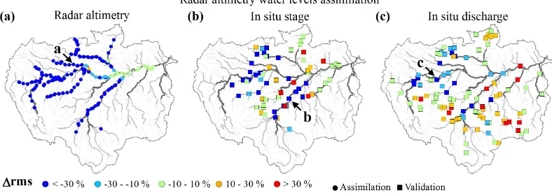
Fig. 4. Evaluation of ENVISAT radar altimetry data assimilation. Spatial distribution of change in root-mean-square error (1rms) at (a) altimetry stations used for data assimilation and stream gauges with (b) stage and (c) discharge data used for verification.
4.2 Radar altimetry data assimilation
In this section, the assimilation of water levels derived from ENVISAT altimetry is evaluated (Exp. 2). Stage and dis-charge data observed at in situ gauging stations were used for validation purposes.
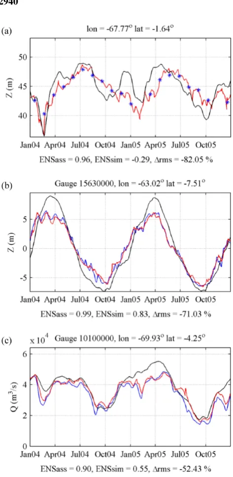
The DA scheme improves water level simulations at al-timetry stations used for assimilation (Fig. 4a), as illustrated in Fig. 5a. On average, rms decreases by 56 % andENS
val-ues increase from 0.66 to 0.96 (Table 2). Simulated water level accuracy also increases when compared to in situ stage data (1rms= −13 %). However, the improvement is more evident if only gauging stations located at rivers where al-timetry data were examined (Figs. 4b and 5b). In this case, mean 1rms equals −43 % and ENS changes from 0.75 to
0.94 (Table 2), similar to what was obtained at altimetry sta-tions. At other sites, the DA scheme has a minor effect on simulated water levels or even degrades results in some cases. Similar results were found for the in situ discharge val-idation sample (Fig. 4c). Assimilating water level data im-proves discharge estimates (1rms= −15 %) mostly at the same rivers in which altimetry data is available (e.g. Fig. 5c). But it also degrades results at some of the other river reaches. The minor improvement of discharge estimates when wa-ter levels are assimilated may related to the fact that wawa-ter level errors are not only related to stream flow or precipita-tion errors, but also to river-floodplain geometry parameters, as discussed by Paiva et al. (2013b). But this kind of model uncertainty was not considered by the DA scheme. Conse-quently, at river reaches where the model already provided accurate discharge estimates but wrong water level results, altimetry data assimilation corrects water levels but it can degrade discharge results. Some possible alternatives to im-prove model discharge results from radar altimetry assimila-tion could be: (i) the simultaneous assimilaassimila-tion of discharge and water level data; (ii) the assimilation of altimetry-based discharge data (tested in Sect. 4.3); (iii) representing the un-certainty of model parameters (e.g. river-floodplain
geome-try) in the DA scheme; (iv) assimilation of altimetry data to first retrieve better river-floodplain geometry parameters (e.g. Durand et al., 2008, 2010b); or (v) assimilation future SWOT data (Durand et al., 2010a), that will provide addi-tional information such as water surface slope.
Furthermore, the DA scheme can degrade results in some reaches where no data were assimilated. Such a problem is possibly caused by spurious correlations in the model co-variance matrix from the EnKF due to a poor sampling from the ensemble. Aiming to avoid spurious correlations, meth-ods such as covariance localisation or local analysis (Sakov and Bertino, 2010) could be used to constrain the influence of observations based on distance criteria as already used in atmospheric or ocean applications. However, in our view, a particular localisation criteria should be developed for hydro-logical applications, since the correlation between the model states can be a function of an Euclidean distance in some cases (e.g. soil moisture) or in others, of a distance measured following the rivers’ path (e.g. river discharge and water lev-els).
Results from this experiment demonstrate that the assimi-lation of radar altimetry data into large scale hydrologic mod-els can improve simulations, mainly in terms of water levmod-els but also in discharge to a minor degree. Even though EN-VISAT data is provided at a 35 day temporal resolution, its assimilation can improve model results at a daily basis as il-lustrated in Fig. 5b and c possibly due to the low temporal variability of Amazonian hydrographs and the fact that EN-VISAT measurements are non-simultaneous.
4.3 Assimilation of discharge series based on satellite altimetry
informa-Table 2. As informa-Table 1 but for Exp. 2.
Sites ENS 1rms (%)
All
Radar altimetry – Assimilation Open-loop 0.66 –
EnKF 0.96 −56.0
In situ stage – Validation Open-loop 0.64 –
EnKF 0.74 −13
In situ discharge – Validation Open-loop 0.68 –
EnKF 0.68 1
Inside ENVISAT In situ stage – Validation
Open-loop 0.75 –
EnKF 0.94 −44
domaina In situ discharge – Validation Open-loop 0.79 –
EnKF 0.86 −15
[image:11.595.133.462.84.240.2]aUpstream and downstream at least one altimetry station.
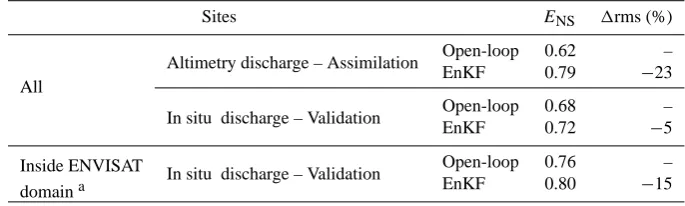
Table 3. As Table 1 but for Exp. 3.
Sites ENS 1rms (%)
All
Altimetry discharge – Assimilation Open-loop 0.62 –
EnKF 0.79 −23
In situ discharge – Validation Open-loop 0.68 –
EnKF 0.72 −5
Inside ENVISAT In situ discharge – Validation Open-loop 0.76 –
domaina EnKF 0.80 −15
aUpstream and downstream at least one altimetry station.
tion which is the most important hydrological variable of the model. In situ discharge data were also used for validation.
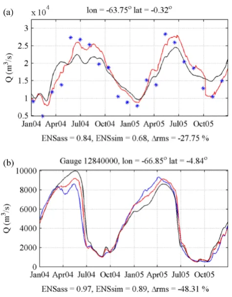
The DA scheme was able to assimilate altimetry-based discharges increasing the agreement between these obser-vations and model results in most of the altimetry stations (Fig. 6a), as exemplified in Fig. 7a. In average, the rms er-ror between altimetry-based discharges and model results decreased 23 % (Table 3), which represents a smaller im-provement if compared to the assimilation of in situ dis-charge (1rms= −49 % in Exp. 1a). Since observation er-rors are larger in the altimetry-based discharges, the DA scheme gives more weight to background model results and updated discharge values are not so close to measurements. The comparison of model results with in situ discharge data (Fig. 6b) shows that errors decrease mostly at gauging sta-tions located at rivers where altimetry data were assimi-lated (e.g. Fig. 7b). At these sites,ENSchanges from 0.76
to 0.80 and the mean1rms is −14 % (Table 3), which is comparable to the improvement obtained in the altimetry data assimilation (Exp. 2, Table 2) over discharge results (1rms= −15 %), but smaller than the enhancement of water level results (1rms= −44 %). Moreover, similarly to Exp. 2, at gauging stations located outside the assimilation domain,
the DA scheme has a minor effect on simulated discharge or degrades results in some cases.
Results from this section show the potential of assimilating discharge data derived from satellite altimetry into large scale hydrological models instead of in situ discharge or satellite water levels, even though such data has lower temporal res-olution and accuracy if compared to data gathered at in situ gauging stations.
4.4 Prospects of streamflow forecasting
[image:11.595.124.467.287.390.2]Fig. 5. Observation (blue line), open-loop simulation (black line) and EnKF simulation (red line) at (a) Japur´a River altimetry site, (b) Madeira River in situ stage site (c) Solim˜oes River in situ discharge site. Sites are indicated in Fig. 4.
We first evaluate hindcast forecasts at the Solim˜oes/Amazon main stem, including upper Solim˜oes River at Tamishiyacu, Solim˜oes River at Manacapuru and Amazon River at ´Obidos (Fig. 8). Notice that these gauges were used by the DA scheme. The model was able to forecast discharges with relatively high accuracy even for very large lead times (90 days). In all cases, forecasts are markedly better than simply using discharge climatology, as shown by positive values of SScli skill score (Fig. 8).
[image:12.595.344.502.70.426.2]As expected, the agreement between model values and
Fig. 6. Evaluation of ENVISAT radar altimetry discharge assim-ilation. Spatial distribution of change in root-mean-square error (1rms) at (a) altimetry stations used for data assimilation and (b) stream gauges with discharge data used for validation.
observations decreases as function of lead time and, for example, SScli decreases from 0.90 to 0.49 for forecasts 10
and 90 days ahead at ´Obidos station. But it remains very high, showing that it would be possible to produce accurate forecasts at the Amazon main river for even larger lead times. Model performance also increases from the upper to the lower part of the Solim˜oes/Amazon River, and at the same time, the spread of the ESP ensemble at large lead times increases upstream and decreases downstream. Such behaviour is explained by the fact that in larger rivers, the hydrological predictability is much more influenced by the current volumes of water stored upstream than by future precipitation forcing, as discussed by Paiva et al. (2012).
sus-Fig. 7. Observation (blue line), open-loop simulation (black line) and EnKF simulation (red line) of discharge at (a) Negro River al-timetry site and (b) Juru´a River in situ site. Sites are indicated in Fig. 6.
pended (Marengo et al., 2008). Even so, the model was able to predict this low flows∼90 days ahead.
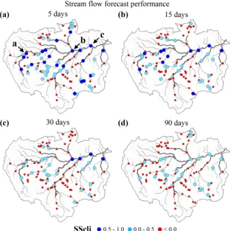
We now evaluate forecasts at gauging stations located all over the Amazon basin. Forecasts for a smaller lead time of 5 days or even 15 days (Fig. 9a and b) were relatively ac-curate with positive SScli values at several gauging stations
located at both upstream and downstream rivers. However, the quality of the forecasts decreased as a function of lead time (30 and 90 days, Fig. 9c and d). It becomes very poor at smaller rivers and remains meaningful with positive SScli
values mainly at gauging stations with large draining areas. For 90 days lead time, SScliindex remains positive at almost
all stations along the Solim˜oes/Amazon main stem and in some of the main tributaries. This behaviour is also illus-trated at Fig. 10. SScli values are usually higher at gauging
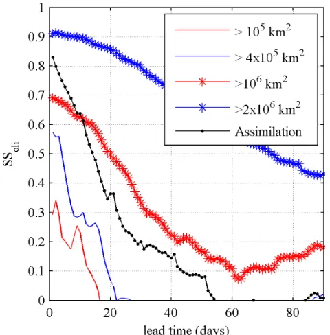
stations located in rivers draining large areas and decrease with lead time. For instance, if only stations gauging rivers with drainage area larger than 105km2 or 4×10⁵km2 are considered, on average, forecasts remain better than clima-tology (SScli >0) up to ∼15 and∼25 days lead time,
re-spectively. On the other hand, if only the largest rivers are taken into account (>106km2), SSclivalues are high and
[image:13.595.49.287.59.363.2]al-ways positive, which demonstrates the good performance of
Fig. 8. Evaluation of streamflow forecasts. Observed (blue), cli-matological (black) discharges, ensemble forecasts (grey) together with ensemble mean (red) at (a) Upper Solim˜oes River at Tamishiy-acu, (b) Solim˜oes River at Manacapuru and (c) Amazon river at
´
[image:13.595.311.545.116.586.2]Fig. 9. Evaluation of streamflow forecasts. Spatial distribution of the skill score SSclifor (a) 5, (b) 15, (c) 30 and (d) 90 days lead time.
the model forecasts. SScliis also high at stream gauges used
for data assimilation where forecasts are usually better, SScli
is close to one for small lead times, as expected, and becomes negative after∼55 days.
5 Summary and conclusions
We presented the development and evaluation of a data as-similation scheme for both gauged and satellite altimetry-based discharge and water levels into a large scale hydrologic-hydrodynamic model of the Amazon River basin using the Ensemble Kalman Filter – EnKF. We also evaluated hindcast forecasts based on this system using the ensemble streamflow prediction approach, where the model was forced by an ensemble of past precipitation forcing from TRMM mission.
According to our results, the data assimilation scheme performed well in assimilating in situ and remotely sensed discharge and water levels into the large scale hydrologic-hydrodynamic model. The assimilation of in situ discharge showed that EnKF can improve discharge estimates at as-similation gauges, but differently from previous studies at
smaller basins (e.g. Clark et al., 2008; and others summarised by Lee et al., 2012), also transfer information to ungauged rivers by improving results at validation sites, although with a smaller degree. The assimilation of discharge data at a re-duced number of gauging stations located at larger rivers im-proves results mostly at the large reaches but it degrades re-sults at some smaller basins. Also, the transformation of dis-charge measurements into the log space proved to be impor-tant to deal with very different discharge magnitudes arising from different spatial scales or from contrasting flood and recession flows.
spa-1
Figure 10. Median skill score
SS
cliof stream flow forecasts at gauging stations as function of
2
lead time. Different curves show results considering gauges with different drainage areas (red
3
and blue lines) and only gauges used for data assimilation (black line with dots).
4
Fig. 10. Median skill score SScliof stream flow forecasts at gauging stations as function of lead time. Different curves show results con-sidering gauges with different drainage areas (red and blue lines) and only gauges used for data assimilation (black line with dots).
tial resolution and the low temporal variability of Amazonian hydrographs.
The sensitivity analysis of the parameter from the DA scheme highlighted the importance of the magnitude of pre-cipitation errors and that of their spatial correlation, while temporal correlation showed to be dispensable.
The deterioration of model performance at some unmoni-tored reaches may be due to the large dimensionality of state space in distributed hydrological models compared to the available information. Consequently, data assimilation may update state variables at some lumped fashion such as the sub-basin scale, as explained by Lee et al. (2012). This prob-lem can be also due to spurious correlations that can arise by numerical reasons and could be avoided by using proper spatial localisation methods (e.g. Sakov and Bertino, 2010) developed for hydrological applications to constrain the in-fluence of measurements. Additionally, the DA scheme could benefit from a better characterisation of model errors, where not only precipitation but other sources of uncertainty, such as in model parameters and structure could be included, as suggested by Liu et al. (2012).
Although limitations still exist, results are encouraging. This kind of DA scheme could also be easily employed to other similar regional/global scale hydrological models (e.g. Yamazaki et al., 2011; Decharme et al., 2011; Alfieri et al., 2013). It has also the potential to improve by assimilat-ing remotely sensed water levels gathered by other satellite
missions as the existing ones, or the altimetry missions to be launched in the coming years by the European Spatial Agency ESA, namely the Sentinel-3 constellation and the forthcoming SWOT mission (Durand et al., 2010a). More-over, the altimetry-based discharge assimilation can improve when better discharge estimates become available, such as the ones under development for the future SWOT mission (Durand et al., 2010b).
Finally, the model was able to provide relatively accurate streamflow forecasts in the Amazon basin. For smaller lead times (∼5 to 15 days), forecasts agreed with observations in lots of gauging stations and for larger lead times (>30 days) they remained meaningful mostly at larger rivers. Fore-casts were usually better at stream gauges used for data assimilation, especially for smaller lead times. Along the Solim˜oes/Amazon main stem, forecast were highly accurate even for very large lead times (90 days) and the model was capable to successfully predict the record 2005 drought at the Solim˜oes/Amazon River well in advance. These results demonstrate the potential for developing stream flow fore-casts with large lead times at the world’s large river basins, such as the Amazon, founded on large scale hydrological models based mostly on initial states gathered with proper DA schemes, and using past climate with the ESP approach. Also, results point to the potentiality of providing hydrolog-ical forecasts at poorly monitored regions by using mostly remotely sensed information.
Acknowledgements. The authors are grateful for: the financial
and operational support from the Brazilian agencies FINEP and ANA (“Projeto de Integrac¸˜ao e Cooperac¸˜ao Amazˆonica para a Modernizac¸˜ao do Monitoramento Hidrol´ogico” ICA-MMH) and CNPq-IRD (“Assimilac¸˜ao de Dados de monitoramento Espacial para a an´alise do regime hidrol´ogico da Bacia Amazˆonica e a previs˜ao de curto e m´edio prazos”); the ENVISAT satellite altimetry data supplied by ESA; the TRMM data supplied by NASA and associated agencies; the TRMM Merge data provided by CPTEC/INPE; the discharge and stage data provided by ANA, Hybam, SENHAMI-Peru and SENHAMI-Bolivia; the EnKF For-tran codes provided by Geir Evensen; the support from Fernando Fan in processing precipitation data; as well as for the constructive comments from Adalberto Meller and Jeffrey Neal, and also from Ross Woods (editor from HESS) and two anonymous reviewers.
Edited by: R. Woods
The publication of this article is financed by CNRS-INSU.
References
Alfieri, L., Burek, P., Dutra, E., Krzeminski, B., Muraro, D., Thie-len, J., and Pappenberger, F.: GloFAS – global ensemble stream-flow forecasting and flood early warning, Hydrol. Earth Syst. Sci., 17, 1161–1175, doi:10.5194/hess-17-1161-2013, 2013. Alsdorf, D. E., Rodrıguez, E., and Lettenmaier, D. P.:
Measur-ing surface water from space, Rev. Geophys., 45, RG2002, doi:10.1029/2006RG000197, 2007.
Andreadis, K. M. and Lettenmaier, D. P.: Assimilating remotely sensed snow observations into a macroscale hydrology model, Adv. Water Resour., 29, 872–886, 2006.
Andreadis, K. M., Clark, E. A., Lettenmaier, D. P., and Als-dorf, D. E.: Prospects for river discharge and depth esti-mation through assimilation of swath-altimetry into a raster-based hydrodynamics model, Geophys. Res. Lett., 34, L10403, doi:10.1029/2007GL029721, 2007.
Biancamaria, S., Durand, M., Andreadis, K. M., Bates, P. D., Boone, A., Mognard, N. M., Rodriguez, E., Alsdorf, D. E., Lettenmaier, D. P., and Clark, E. A.: Assimilation of virtual wide swath al-timetry to improve Arctic river modelling, Remote Sens. Envi-ron., 115, 373–381, 2011.
Chen, J. L., Wilson, C. R., and Tapley, B. D.: The 2009 excep-tional Amazon flood and interannual terrestrial water storage change observed by GRACE, Water Resour. Res., 46, W12526, doi:10.1029/2010WR009383, 2010.
Clark, M. P., Rupp, D. E., Woods, R. A., Zheng, X., Ibbitt, R. P., Slater, A. G., Schmidt, J., and Uddstrom, M. J.: Hy-drological data assimilation with the ensemble Kalman fil-ter: Use of streamflow observations to update states in a dis-tributed hydrological model, Adv. Water Res., 31, 1309–1324, doi:10.1016/j.advwatres.2008.06.005, 2008.
Coe, M. T., Costa, M. H., and Howard, E. A.: Simulating the sur-face waters of the Amazon River basin: Impacts of new river geo-morphic and flow parameterizations, Hydrol. Process., 22, 2542– 2553, 2008.
Collischonn, W., Allasia, D. G., Silva, B. C., and Tucci, C. E. M.: The MGB-IPH model for large-scale rainfall-runoff modelling, Hydrolog. Sci. J., 52, 878–895, 2007.
Day, G. N.: Extended streamflow forecasting using NWSRFS, J. Water Resour. Plann. Manage., 111, 157–170, 1985.
Decharme, B., Alkama, R., Papa, F., Faroux, S., Douville, H., and Prigent, C.: Global off-line evaluation of the ISBA-TRIP flood model, Clim. Dynam., 38, 1389–1412, doi:10.1007/s00382-011-1054-9, 2011.
Durand, M., Andreadis, K. M., Alsdorf, D. E., Lettenmaier, D. P., Moller, D., and Wilson, M.: Estimation of bathymetric depth and slope from data assimilation of swath altimetry into a hydrodynamic model, Geophys. Res. Lett., 35, L20401, doi:10.1029/2008GL034150, 2008.
Durand, M., Fu, L. L., Lettenmaier, D. P., Alsdorf, D. E., Rodr´ıguez, E., and Fernandez, D. E.: The surface water and ocean topog-raphy mission: Observing terrestrial surface water and oceanic submesoscale eddies, Proc. IEEE, 98, 766–779, 2010a. Durand, M., Rodr´ıguez, E., Alsdorf, D., and Trigg, M.: Estimating
River Depth From Remote Sensing Swath Interferometry Mea-surements of River, IEEE J. Sel. Top. Appl., 3, 20–31, 2010b. Espinoza, J. C., Ronchail, J., Guyot, J. L., Cocheneau, G., Filizola,
N., Lavado, W., de Oliveira, E., Pombosa, R., and Vauchel, P.: Spatio-Temporal rainfall variability in the Amazon Basin
Coun-tries (Brazil, Peru, Bolivia, Colombia and Ecuador), Int. J. Cli-matol., 29, 1574–1594, 2009.
Espinoza, J. C., Ronchail, J., Guyot, J. L., Junquas, C., Vauchel, P., Lavado, W., Drapeau, G., and Pombosa, R.: Climate variabil-ity and extreme drought in the upper Solim˜oes River (western Amazon Basin): Understanding the exceptional 2010 drought, Geophys. Res. Lett., 38, L13406, doi:10.1029/2011GL047862, 2011.
Evensen, G.: The ensemble Kalman filter: theoretical formula-tion and practical implementaformula-tion, Ocean Dynam., 53, 343–367, 2003.
Evensen, G.: Sampling strategies and square root analysis schemes for the EnKF, Ocean Dynam., 54, 539–560, 2004.
Evensen, G.: Data assimilation, The Ensemble Kalman Filter, 2nd Edn., Springer, 2009.
Farr, T. G., Caro, E., Crippen, R., Duren, R., Hensley, S., Kobrick, M., Paller, M., Rodriguez, E., Rosen, P., Roth, L., Seal, D., Shaf-fer, S., Shimada, J., Umland, J., Werner, M., Burbank, D., Oskin, M., and Alsdorf, D.: The shuttle radartopography mission, Rev. Geophys., 45, RG2004, doi:10.1029/2005RG000183, 2007. Frappart, F., Ramillien, G., Maisongrande, P., and Bonnet,
M-P.: Denoising satellite gravity signals by Independent Compo-nent Analysis, IEEE Geosci. Remote Sens. Lett., 7, 421–425, doi:10.1109/LGRS.2009.2037837, 2010.
Frappart, F., Ramillien, G., Leblanc, M., Tweed, S. O., Bon-net, M.-P., and Maisongrande, P.: An Independent Component Analysis approach for filtering continental hydrology in the GRACE gravity data, Remote Sens. Environ., 115, 187–204, doi:10.1016/j.rse.2010.08.017, 2011.
Gedney, N., Cox, P. M., and Huntingford, C.: Climate feed-back from wetland methane emission, Geophys. Res. Lett., 31, L20503, doi:10.1029/2004GL020919, 2004.
Getirana, A. C. V. and Peters-Lidard, C.: Estimating water discharge from large radar altimetry datasets, Hydrol. Earth Syst. Sci., 17, 923–933, doi:10.5194/hess-17-923-2013, 2013.
Getirana, A. C. V., Boone, A., Yamazaki, D., Decharme, B., Papa, F., and Mognard, N.: The Hydrological Modelling and Analysis Platform (HyMAP): evaluation in the Amazon basin, J. Hydrom-eteor, 13, 1641–1665, doi:10.1175/JHM-D-12-021.1, 2012. Giustarini, L., Matgen, P., Hostache, R., Montanari, M., Plaza, D.,
Pauwels, V. R. N., De Lannoy, G. J. M., De Keyser, R., Pfister, L., Hoffmann, L., and Savenije, H. H. G.: Assimilating SAR-derived water level data into a hydraulic model: a case study, Hydrol. Earth Syst. Sci., 15, 2349–2365, doi:10.5194/hess-15-2349-2011, 2011.
Hess, L. L., Melack, J. M., Novo, E. M. L. M., Barbosa, C. C. F., and Gastil, M.: Dual-season mapping of wetland inundation and vegetation for the central Amazon basin, Remote Sens. Environ., 87, 404–428, 2003.
Hostache, R., Lai, X., Monnier, J., and Puech, C.: Assimilation of spatially distributed water levels into a shallow-water flood model. Part II: Use of a remote sensing image of Mosel River, J. Hydrol., 390 257–268, 2010.
Huffman, G., Adler, R., Bolvin, D., Gu, G., Nelkin, E., Bowman, K., Hong, Y., Stocker, E., and Wolff, D.: The TRMM Multi-satellite Precipitation Analysis (TCMA): quasi-global, multiyear, combined-sensor precipitation estimates at fine scales, J. Hy-dromet, 8, 38–55, 2007.
Kalman, R. E.: A new approach to linear filtering and prediction problems, Trans. AMSE – J. Basic Eng., 82 D, 35–45, 1960. Krinner, G.: Impact of lakes and wetlands on boreal climate, J.
Geo-phys. Res., 108, 4520, doi:10.1029/2002JD002597, 2003. Kumar, S. V., Reichle, R. H., Peters-Lidard, C. D., Koster, R. D.,
Zhan, X., Crow, W. T., Eylander, J. B., and Houser, P. R.: A Land Surface Data Assimilation Framework using the Land Informa-tion System: DescripInforma-tion and ApplicaInforma-tions, Adv. Water Resour., 31, 1419–1432, DOI:10.1016/j.advwatres.2008.01.013, 2008. Lee, H., Seo, D.-J., and Koren, V.: Assimilation of streamflow
and in situ soil moisture data into operational distributed hy-drologic models: Effects of uncertainties in the data and initial model soil moisture states, Adv. Water Resour., 34, 1597–1615, doi:10.1016/j.advwatres.2011.08.012, 2011.
Lee, H., Seo, D.-J., Liu, Y., Koren, V., McKee, P., and Corby, R.: Variational assimilation of streamflow into operational distributed hydrologic models: effect of spatiotemporal scale of adjustment, Hydrol. Earth Syst. Sci., 16, 2233–2251, doi:10.5194/hess-16-2233-2012, 2012.
Leon, J. G., Calmant, S., Seyler, F., Bonnet, M.-P., Cauhop´e, M., and Frappart, F.: Rating curves and average water depth at the Upper Negro river from satellite altimetry and modelled discharges, J. Hydrol., 328, 481–496, 2006.
Liu, Y. and Gupta, H. V.: Uncertainty in hydrologic modelling: To-ward an integrated data assimilation framework, Water Resour. Res., 43, W07401, doi:10.1029/2006WR005756, 2007. Liu, Y., Weerts, A. H., Clark, M., Hendricks Franssen, H.-J., Kumar,
S., Moradkhani, H., Seo, D.-J., Schwanenberg, D., Smith, P., van Dijk, A. I. J. M., van Velzen, N., He, M., Lee, H., Noh, S. J., Rakovec, O., and Restrepo, P.: Advancing data assimilation in operational hydrologic forecasting: progresses, challenges, and emerging opportunities, Hydrol. Earth Syst. Sci., 16, 3863–3887, doi:10.5194/hess-16-3863-2012, 2012.
Marengo, J., Nobre, C., Tomasella, J., Oyama, M., de Oliveira, G., de Oliveira, R., Camargo, H., and Alves, L.: The drought in Ama-zonia in 2005, J. Climate, 21, 495–516, 2008.
Marengo, J. A., Tomasella, J., Alves, L. M., Soares, W. R., and Ro-driguez, D. A.: The drought of 2010 in the context of historical droughts in the Amazon region, Geophys. Res. Lett., 38, L12703, doi:10.1029/2011GL047436, 2011.
Matgen, P., Montanari, M., Hostache, R., Pfister, L., Hoffmann, L., Plaza, D., Pauwels, V. R. N., De Lannoy, G. J. M., De Keyser, R., and Savenije, H. H. G.: Towards the sequential assimilation of SAR-derived water stages into hydraulic models using the Par-ticle Filter: proof of concept, Hydrol. Earth Syst. Sci., 14, 1773– 1785, doi:10.5194/hess-14-1773-2010, 2010.
McMillan, H. K., Hreinsson, E. ¨O., Clark, M. P., Singh, S. K., Za-mmit, C., and Uddstrom, M. J.: Operational hydrological data assimilation with the recursive ensemble Kalman filter, Hydrol. Earth Syst. Sci., 17, 21–38, doi:10.5194/hess-17-21-2013, 2013. Meade, R. H., Rayol, J. M., Da Conceic¸˜ao, S. C., and Natividade, J. R. G.: Backwater effects in the Amazon River basin of Brazil, Environ. Geol. Water Sci., 18, 105–114, 1991.
Melack, J. M. and Hess, L. L.: Remote sensing of the distribu-tion and extent of wetlands in the Amazon basin, in: Amazonian floodplain forests: ecophysiology, ecology, biodiversity and sus-tainable management, edited by: Junk, W. J. and Piedade, M., Ecological Studies, Vol. 210, Part 1, Springer, 43–59, 2010. Neal, J. C., Atkinson, P. M., and Hutton, C. W.: Flood inundation
model updating using ensemble Kalman filter and spatially dis-tributed measurements, J. Hydrol., 336, 401–415, 2007. Neal, J. C., Schumann, G. J.-P., Bates, P. D., Buytaert, W., Matgen,
P., and Pappenberger, F.: A data assimilation approach to dis-charge estimation from space, Hydrol. Process., 23, 3641–3649, doi:10.1002/hyp.7518, 2009.
New, M., Lister, D., Hulme, M., and Makin, I.: A high-resolution data set of surface climate over global land areas, Clim. Res., 21, 1–25, 2002.
Nijssen, B. and Lettenmaier, D.: Effect of precipitation sampling er-ror on simulated hydrological fluxes and states: Anticipating the Global Precipitation Measurement satellites, J. Geophys. Res., 109, D02103, doi:10.1029/2003JD003497, 2004.
Oki, T. and Kanae, S.: Global hydrological cycles and world water resources, Science, 313, 1068–1072, doi:10.1126/science.1128845, 2006.
Paiva, R. C. D., Collischonn, W., and Tucci, C. E. M.: Large scale hydrologic and hydrodynamic modelling using limited data and a GIS based approach, J. Hydrol., 406, 170–181, 2011.
Paiva, R. C. D., Collischonn, W., Bonnet, M. P., and de Gonc¸alves, L. G. G.: On the sources of hydrological prediction uncer-tainty in the Amazon, Hydrol. Earth Syst. Sci., 16, 3127–3137, doi:10.5194/hess-16-3127-2012, 2012.
Paiva, R. C. D., Collischonn, W., and Buarque, D. C.: Vali-dation of a full hydrodynamic model for large scale hydro-logic modelling in the Amazon, Hydrol. Process., 27 333–346, doi:10.1002/hyp.8425, 2013a.
Paiva, R. C. D., Collischonn, W., Bonnet, M.-P., Buarque, D. C., Frappart, F., Calmant, S., and Mendes, C. B.: Large scale hydro-logic and hydrodynamic modelling of the Amazon River basin, Water Resour. Res., 49, 1226–1243, doi:10.1002/wrcr.20067, 2013b.
Papa, F., Durand, F., Rossow, W. B., Rahman, A., and Bala, S. K.: Satellite altimeter-derived monthly discharge of the Ganga-Brahmapoutra River and its seasonal to interannual vari-ations from 1993 to 2008, J. Geophys. Res., 115, C12013, doi:10.1029/2009JC006075, 2010a.
Papa, F., Prigent, C., Aires, F., Jimenez, C., Rossow, W. B., and Matthews, E.: Interannual variability of surface water extent at the global scale, 1993–2004, J. Geophys. Res., 115, D12111, doi:10.1029/2009JD012674, 2010b.
Pereira-Cardenal, S. J., Riegels, N. D., Berry, P. A. M., Smith, R. G., Yakovlev, A., Siegfried, T. U., and Bauer-Gottwein, P.: Real-time remote sensing driven river basin modelling using radar altime-try, Hydrol. Earth Syst. Sci., 15, 241–254, doi:10.5194/hess-15-241-2011, 2011.
Reichle, R. H.: Data assimilation methods in the Earth sciences, Adv. Water Resour., 31, 1411–1418, doi:10.1016/j.advwatres.2008.01.001, 2008.
Reichle, R. H., Mclaughlin, D. B., and Entekhabi, D.: Hydrologic Data Assimilation with Ensemble Kalman Filter, Mon. Weather Rev., 130, 103–114, 2002.
Ricci, S., Piacentini, A., Thual, O., Le Pape, E., and Jonville, G.: Correction of upstream flow and hydraulic state with data assim-ilation in the context of flood forecasting, Hydrol. Earth Syst. Sci., 15, 3555–3575, doi:10.5194/hess-15-3555-2011, 2011. Rozante, J. R., Moreira, D. S., de Goncalves, L. G. G.,
and Vila, D .A.: Combining TRMM and Surface Ob-servations of Precipitation: Technique and Validation over South America, Weather Forecast., 25, 885–894, doi:http://dx.doi.org/10.1175/2010WAF2222325.1, 2010. Sakov, P. and Bertino, L.: Relation between two common
local-isation methods for the EnKF, Comput. Geosci., 15, 225–237, doi:10.1007/s10596-010-9202-6, 2010.
Santos da Silva, J., Calmant, S., Seyler, F., Rotunno Filho, O. C., Cochonneau, G., and Mansur, W. J.: Water levels in the Ama-zon basin derived from the ERS 2 and ENVISAT radar altimetry missions, Remote Sens. Environ., 114, 2160–2181, 2010. Thielen, J., Bartholmes, J., Ramos, M.-H., and de Roo, A.: The
Eu-ropean Flood Alert System – Part 1: Concept and development, Hydrol. Earth Syst. Sci., 13, 125–140, doi:10.5194/hess-13-125-2009, 2009.
Thirel, G., Martin, E., Mahfouf, J.-F., Massart, S., Ricci, S., and Habets, F.: A past discharges assimilation system for ensemble streamflow forecasts over France – Part 1: Description and val-idation of the assimilation system, Hydrol. Earth Syst. Sci., 14, 1623–1637, doi:10.5194/hess-14-1623-2010, 2010.
Tian, Y. and Peters-Lidard, C. D.: A global map of uncertainties in satellite-based precipitation measurements, Geophys. Res. Lett., 37, L24407, doi:10.1029/2010GL046008, 2010.
Tomasella, J., Borma, L. S., Marengo, J. A., Rodriguez, D. A., Cuar-tas, L. A., Nobre, C. A., and Prado, M. C. R.: The droughts of 1996–1997 and 2004–2005 in Amazonia: hydrological re-sponse in the river main-stem, Hydrol. Process., 25, 1228–1242, doi:10.1002/hyp.7889, 2010.
Trigg, M. A., Wilson, M. D., Bates, P. D., Horritt, M. S., Alsdorf, D. E., Forsberg, B. R., and Vega, M. C.: Amazon flood wave hydraulics, J. Hydrol., 374, 92–105, 2009.
Uvo, C. B. and Graham, N. E.: Seasonal runoff forecast for north-ern South America: A statistical model, Water Resour. Res., 34, 3515–3524, doi:10.1029/98WR02854, 1998.
Uvo, C. B., T¨olle, U., and Berndtsson, R.: Forecasting discharge in Amazonia using artificial neural networks, Int. J. Climatol., 20, 1495–1507, doi:10.1002/1097-0088(200010)20:12<1495::AID-JOC549>3.0.CO;2-F, 2000.
Vrugt, J. A., Diks, C. G. H., Gupta, H. V., Bouten, W., and Verstraten, J. M.: Improved treatment of uncertainty in hydro-logic modelling: Combining the strengths of global optimiza-tion and data assimilaoptimiza-tion, Water Resour. Res., 41, W01017, doi:10.1029/2004WR003059, 2005.
Wilks, D. S.: Statistical Methods in the Atmospheric Sciences, 2st Edn. Academic Press, 627 pp., 2006.
Wilson, W., Bates, P., Alsdorf, D., Forsberg, B., Horritt, M., Melack, J., Frappart, F., and Famiglietti, J.: Modelling large-scale inunda-tion of Amazonian seasonally flooded wetlands, Geophys. Res. Lett., 34, L15404, doi:10.1029/2007GL030156, 2007.
Wood, A. W., Maurer, E., Kumar, A., and Lettenmaier, D. P.: Long-range experimental hydrologic forecasting for the eastern United States, J. Geophys. Res., 107, 4429, doi:10.1029/2001JD000659, 2002.