2956
DEVELOPING A WEB-BASED ADVISOR EXPERT SYSTEM
FOR GREEN TRANSPORTATION SYSTEM
1HASSAN M ABDELSALAM*, 2MUHAMMAD NAZRI BORHAN, 1ABDALRHMAN MILAD,
1HAMZA IMHIMMED,2RIZA ATIQ OK RAHMAT,
1
Sustainable Urban Transport Research Centre (SUTRA), Faculty of Engineering, Universiti Kebangsaan Malaysia, 43600 Selangor Darul Ehsan, Malaysia
2
Department of Civil & Structural Engineering, Faculty of Engineering, Universiti Kebangsaan Malaysia, 43600 Selangor Darul Ehsan, Malaysia
Corresponding Author: Email: [email protected]
ABSTRACT
Considering the sustained and pervasive popularity of the private vehicle not only in Malaysia National University (UKM) but in most of Malaysian Universities, what makes people prefer to use a Bicycle rather than car or public transport? What will facilitate the use the bicycle paths to the promotion of more sustainable behavior and the achievement of the green transportation targets? In this paper, a web-based advisory expert system for the purpose of applying Geometric Design of bicycle paths on residential streets is described because of their currently a weakness in the educational outcomes and structured framework for the implementation of such strategies . Developing an expert system can assist and advise engineers for dealing with geometric design problems. This expert system is developed to fill the gap between the sustainable urban design experts and people who seek to employ Geometric Design of bicycle paths including decision makers, engineers, and students. The system has more than six main functions including classifying, bicycle paths width, Separation from road way, Horizontal alignment, sight distance, and grades design .Verifying, validating processes, and comparing the system with similar works have shown that the system is consistent and acceptable for practical uses. In order to build the expert system, examining sources related to bicycle sharing path studies as well as interviewing with domain experts have been carried out. The system includes rules and images for different types of measures finally, some recommendations for improving the system are presented.
Keyword:Expert System; Green Transportation System
1.INTRODUCTION
Urban transportation should have the ability to cope with the dense areas while shifting people and goods. Density generates issues for urban transportation due to crowding and the cost of offering infrastructure in built-up areas. It generates specific benefits due to economies of scale: certain transportation activities are cost effective when carried out in large volumes. These traits means that two of the most important phenomenon in urban transportation are traffic congestion and mass transit.[1]. In particular cases, even the environmental impacts of particular transportation modes can be revealed. Then the discrete-choice model based on these data can forecast and test how and in which way travel time and cost in addition to passenger characteristics influencing the miscellany of
2957 the number of road trips, discovering that daily trips increase at the rate of 0.8 daily trips per additional family member. Studies also reveal that the number of road trips increases with the increase of the number of members employed in a single family[4]. A link exists between the socio-economic traits of a population and traffic movement in general. Most transport-related urban planning studies underline the correlation between a family’s average monthly income and the number of road trips per day of its members. This is because the higher a family’s income is, the greater purchasing power they have, with varied needs. Hence, a greater of number of trips are required to satisfy family needs [5]. Another pertinent evidence is that the household income proportion being expended on transport and travel holds continuously over time once the car
ownership has reached around one per
household[6].In Britain, the expenditure has oscillated about 16% for the past 25 years (National Statistics, 2004; Metz, 2005). This does not go well with the idea that travelers are inspired to lessen travel expenses, at least in the long run.[7].Via clear planning strategies being combined, cities are planned at the individual scale allowing both high-quality convenience and a superior environment. The purpose is not to forbid the usage of the car, as this would be both complicated to achieve and would be viewed as against ideas of freedom and choice. The intention is to design cities with such superiority and at an appropriate scale that people would not see the need of having a car [8]. There is a marked growth in the use of private automobiles today. The ownership of private vehicles is one of the important factors affecting the generation of daily trips. It contributes to traffic congestion on urban roads and is the cause of many road accidents. In most countries, the per capita share of private vehicle ownership has increased. Private vehicle ownership is one of the indicators used in estimating future urban transport demand. A recent study of Harvard University discovered that 22% of U.S. cities largest populations live within a three-mile radius from the city center (the main commercial and industrial areas ), and almost 80% at distances of up to 30 miles outside the city borders. Obviously, this leads to a high rate of energy consumption. In Europe, on the other hand, one can finish a day’s work in Geneva, Switzerland and arrive in central Paris, France less than two hours later, getting off the train before the doorstep of the place of destination (hotel or company etc.). This is because most European
cities are dependent on a model rail network that connects all European city centers [9]. Energy consumption is a necessity of socio-economic development. Transport (the sector that consumes the most energy) constitutes one of the major
challenges facing sustainable development
because it is a source of pollution that is harmful to both the environment (globally, regionally and locally) and to human health. This predicament has long puzzled countries across the globe [10].
2.LITERATURE REVIEW
2.1.E-ACTIVERANS
Improving specialist system is meant to prepare the youthful expert to actualize portability administration methodologies with a specific end goal that impacts a movement from latent to dynamic transport decision, which is cycling and strolling. One of the procedures included in
learning obtaining of dynamic transport
methodologies is to catch the perspectives of transportation specialists in regards to the most suitable techniques with respect to the movement from mechanized transport to dynamic transport .[11].
2.2.CALMSYS
This Expert system created helps beginner transportation engineers to manage an activity’s wellbeing issues in private neighborhoods and private gatherer lanes. In CALMSYS, activity wellbeing issues have been isolated into diverse classifications and end clients are empowered to locate their own issues. Accordingly, the system will give significant counsel CALMSYS is intended to cover arrangements and suggestions which can be connected to diminish the negative effects of mechanized vehicles, much of the time mischance focuses and trip generator regions [12].
2.3.ES-CCPRHP
Highway construction faces complex issues, which are influenced by various variables where the arrangement is unimaginable without master help. Diagnosing such development issues and proposing the most suitable cost proficient arrangements requires huge building mastery, which would not be accessible in all development destinations because of insufficient asset and remote areas .[13].
2.4. E-ASSIST
2958 principle goals actualizing TDM. Selecting one that matches the issue the client is experiencing in existing circumstance keeping in mind the objective to see the full target depiction [14].
One procedure for obtaining green transport methodologies is to capture the views of transport specialists on the best techniques for a transition from regular to green transport. Choose one that matches the problem faced by the client in the current circumstances taking into account the goal to see the full goal of thinking about green transport .This is mainly due to most of the decision maker at local organizations interviewed for the data
collection were reported: "There is no plan to establish a green transport infrastructure for new projects in residential areas, hotels, businesses, etc., e.g. Non-motorized networks, etc.
3.METHODOLGY
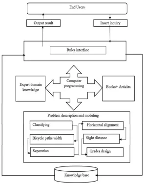
The system has more than six main functions
including classifying, bicycle paths width,
[image:3.612.168.463.254.631.2]Separation from road way, Horizontal alignment, sight distance, and grades design. The diagram below showing Structure of knowledge-based expert system.
Figure 1: Structure Of Knowledge-Based Expert System
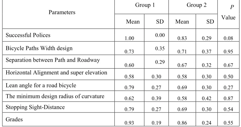
Two questionnaires were designed and distributed among the experts. In the first questionnaire, experts were asked to select the importance of each parameter in the study, which were elicited through the above methods, according to a 5-point Liker Scale. In this rating scale, 1 means strongly
2959 specify the associated there should and conditions of the related green transportation parameters.
After collecting questionnaires, the data was analyses by SPSS software. Mean values and standard values were calculated as shown in table 1. ANOVA was used in order to determine whether the answers of the two groups of experts were significantly different from each other or not.
[image:4.612.106.505.252.462.2]According to the value in table 1, no significant difference between the groups was found. This means that experts with different lengths of relevant experience have similar notions toward the importance of the parameters contained in the expert system.
Table 1: Results From The Questionnaire About The Importance Of The Parameters.
Parameters
Group 1 Group 2 P
Value
Mean SD Mean SD
Successful Polices
1.00 0.00 0.83 0.29 0.08
Bicycle Paths Width design
0.73 0.35 0.71 0.37 0.95 Separation between Path and Roadway
0.60 0.29 0.67 0.32 0.67 Horizontal Alignment and super elevation
0.58 0.30 0.58 0.30 0.50
Lean angle for a road bicycle 0.79 0.27 0.69 0.30 0.27
The minimum design radius of curvature 0.62 0.39 0.58 0.42 0.87
Stopping Sight-Distance 0.79 0.27 0.69 0.30 0.54
Grades
0.93 0.19 0.86 0.24 0.55
4. KNOWLEDGE REPRESNTATION
To store and keep expert knowledge in the knowledge base, the data must be transformed into the form of symbols, conditional statements, logical
expressions, logical operations, and logical
variables that are recognizable and applicable to computer systems. In the present study, Microsoft Visual Studio and ASP.NET are used to construct the proposed expert system. The knowledge base in the prototype system is represented in the form of production rules. Rules are considered as a suitable form of knowledge representation, and Microsoft Visual Studio and ASP.NET are well-known applications for developing rule-based systems. Hence, for this rule-based expert system, a forward chaining inference engine is used rather than a backward chaining process. In a forward chaining inference engine, the process begins with the facts stored in the knowledge base. IF-THEN statements are commonly used and are useful constructs for building rule-based expert systems. In this form, IF
represents a condition and THEN represents a determination. Rules can be aggregated by employing connection terms, including OR, AND, and ELSE to shape combined rules or composite rules.
5.RESULTS
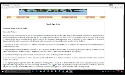
5.1. Building Tool for (Web–based Advisor
Expert System)
high-2960
level programming languages, including
maintenance problems, and weak documentation. In addition, sometimes a knowledge base or the inference engine of a system cannot be modeled in an expert system shell; hence, two or more shells must be used. These conditions lead to unsatisfactory systems with unclear results and significant maintenance and training problems. Developers of expert systems must select an appropriate building tool that can be implemented within existing constraints such as money, time, and available hardware. In addition, the nature of the intended expert system is an important factor for choosing a building tool. An expert system that requires a complicated structure and user interface must be developed using high-level building tools rather than using expert system shells. Moreover, the quality and availability of support facilities, maintenance, and level of reliability must be taken into account. Microsoft Visual Studio and ASP.NET are powerful applications that have tools that non-technical employees can use to build windows or web-based applications for expert systems quickly and efficiently.
5.2.Bicycle -lane design
5.2.1. Successful Polices
A local authority should consider the travel needs of all users of a transportation corridor when planning transportation improvements. Bicycle facilities must be considered on all Federal-aid projects and, If it is determined that the volume and character of existing and potential bicycle travel in the vicinity of a project justify the provision of
bicycle facilities, provide the appropriate
accommodations. Base the provision of bicycle facilities on anticipated demand and traffic safety considerations. The following guidelines may be used in considering the need for bicycle facilities
[image:5.612.315.532.164.295.2].
Figure 2: The Guidelines Used In Considering The Need For Bicycle Facilities.
5.2.2.Bicycle Paths Width design
[image:5.612.315.533.424.549.2]Widths for shared use bicycle paths will vary in accordance with the conditions illustrates the minimum cross sections for two-way, shared-use paths.
Figure 3: Bicycle Paths Design
5.2.3. Separation between Path and Roadway
The separation distance between a path and a roadway depends primarily on the posted speed limit of the road. Recommended separations for rural (shoulder and ditch) and urban (curb and gutter) road cross sections are illustrated and shows a well-designed separation of a shared-use path from an adjacent roadway.
Figure 4: Separations For Rural (Shoulder And Ditch) & (Curb And Gutter)
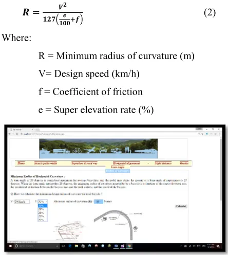
5.2.4. Horizontal Alignment and super elevation
[image:5.612.90.302.575.703.2]2961 the speed at which a bicyclist can travel safely and
comfortably are curvature, super elevation,
gradient, and width of the traveled way. In addition, factors such as traffic, intersections, type of bicycle, physical condition of the rider, wind, and surface condition also affect the bicyclist’s speed. Moreover we apply the horizontal alignment and super elevation by calculate lean angle and the minimum design radius of curvature as shown below.
i)Lean angle for a road bicycle
Unlike an automobile, a bicycle must be leaned while cornering to prevent it from falling outward due to the centrifugal force. The balance of centrifugal force due to cornering, and the bicycle’s downward force due to its mass, act through the bicycle and operator’s combined center of mass which intersects a line that connects the front and rear tire contact points. The minimum radius of horizontal curvature depends on design speed, rate of super elevation, coefficient of friction and the allowable lean angle of the bicyclist. By ignoring the coefficient of friction and the super elevation
rate, the equation shown in Figure 3.43can be used
to find the approximate bicyclist lean angle for a given curve radius and bicyclist speed.
. ∗
(1)
Where:
R= Radius of curvature (m)
V= Design speed (km/h)
Ɵ = Lean angle from the vertical (degrees)
[image:6.612.312.534.219.467.2]Desirable minimum radius of horizontal curvature (based on 15-degree lean angle)
Figure 5: Bicyclist Lean Angle For A Given Curve
Radius And Bicyclist Speed
ii)The minimum design radius of curvature
A lean angle of 20 degrees is considered maximum for average bicyclists, and the pedal may strike the ground at a lean angle of approximately 25 degrees. When the lean angle approaches 20 degrees, the minimum radius of curvature negotiable by a bicycle is a function of the super elevation rate, the coefficient of friction between the bicycle tires and the path surface, and the speed of the bicycle.
(2)
Where:
R = Minimum radius of curvature (m)
V= Design speed (km/h)
f = Coefficient of friction
e = Super elevation rate (%)
Figure 6: Minimum Radius For Paved Shared – Use
Paths
5.2.5. Stopping Sight-Distance
For sight distance calculations, assume the bicyclist’s combined perception and brake reaction time is 2.5 seconds. The height of eye for a bicyclist is 4.5 ft (1.4 m) and the height of object is 0.0 ft (0.0 m). The coefficient of friction between tire and pavement is 0.25 for wet-weather braking conditions. Use the following equations to determine the applicable sight distance for bicycle paths:
. (3)
Where:
S= Stopping distance
V= Velocity (km/h)
2962 G= Grade (m/m) (rise /run)
Figure 7: Determine The Applicable Sight Distance
For Bicycle Paths
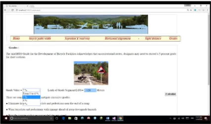
5.2.6. Grades
The AASHTO Guide for the Development of Bicycle Facilities acknowledges that on recreational routes, designers may need to exceed a 5 percent grade for short sections. It recommends several methods to mitigate excessive grades:
Eliminate hazards to the bicyclists and pedestrians near the end of a ramp
Warn bicyclists and pedestrians with signage ahead of steep downgrade hazards
Provide signage stating recommended descent speed
Exceed minimum stopping sight-distances When practical, widen the path by 1.2 - 1.8 m (4 - 6 ft) to provide space for slower speed bicyclists to dismount and walk
Provide a series of short switchbacks near the top to contain the speed of descending bicyclists.
For paths with crushed aggregate surfaces, grades less than 3 percent are preferred due to the risk of skidding, as well as for erosion control.
Figure 8: Determine The Grades Design For
Bicycle Path
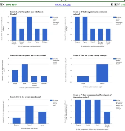
5.3. Verifying And Validating Processes
Verifying and validating processes very important for comparing the system with similar works for the show that system is consistent and acceptable for practical uses. Questionnaires were designed and distributed among two groups of the (UKM) students, novice engineer, and post-graduate students. In this questionnaire, novice engineer was asked to select the importance and the priority of each process in the study, which was elicited through the above methods, according to a 6-question. In this rating scale, A= is the system user interface is friendly? B= is the system runs commands quickly? C= is the system has correct codes? D= is the system having no bugs? E= is the system easy to use? , and F= means can you access to different parts of the system easily?
After collecting questionnaires, the data was analyzed. The values were calculated as shown in the figures from A to F.In order to determine whether the answers of the two groups of students were significantly different from each other or not. According to the value, no significant difference between the groups was found. This means that students with different lengths of relevant experience have similar notions toward the importance and propriety of the contained in the expert system, as well as developing a web-based advisor for enhancing the output of geometric design of a bicycle path for application of green transportation.
Furthermore, in this questionnaire, in the event that student's felt the given expert system could present
the problems and that employing green
[image:7.612.93.306.554.679.2]2963
Figure 9: Verifying And Validating Processes
6.CONCLUSION
The green Transportation modes by using bicycle path design constitute a large part of any urban city’s area and vital facilities and are the lifeline that provides the city with the means for living. This paper explored the concept of using a web knowledge-based expert system to provide advice, strategies, and design inputs in the development of a green transportation plan by using bicycle path design and conducted a successful trial in developed the cities. The expert system is intended to assist the novice engineer and new professional in making decisions before they decide to implement green transportation strategies in their
transportation systems. The solution is derived from various documented publications for green transportation modes by using bicycle path design and focusing on green transportation strategies. In terms of the environment conservation, business efficiency, public health, and extending road capacity of bicycle path to levels that can keep abreast with the predicted growth in traffic, current methods of traffic management are unsustainable. The advice and strategies obtained from the expert system can be used to aid novice engineers in their efforts toward the implementation of a green
transportation plan without referring to
2964
REFERENCES
[1] K. A. Small and J. A. Gomez-Ibanez,
"Urban transportation," Handbook of
regional and urban economics, vol. 3, pp.
1937-1999, 2008.
[2] F. Ülengin, Ö. Özaydın, B. Ülengin, A.
Kopp, Ş. Önsel, Ö. Kabak, et al., "Are road transportation investments in line with demand projections? A gravity-based
analysis for Turkey," Transport Policy,
vol. 29, pp. 227-235, 2013.
[3] P. Newman, "The environmental impact of
cities," Environment and Urbanization,
vol. 18, pp. 275-295, 2006.
[4] D. Z. E. A. Ali, Mabade’ takhteet al naql
2000.
[5] W. H. A. Hussein, "A sustainable planning
approach to resolving transportation hub problems in Egyptian cities “proposed
measurement matrix”," American Journal
of Environmental Protection, 2015.
[6] A. Schafer and D. G. Victor, "The future
mobility of the world population,"
Transportation Research Part A: Policy
and Practice, vol. 34, pp. 171-205, 2000.
[7] D. Metz, "The myth of travel time saving,"
Transport reviews, vol. 28, pp. 321-336,
2008.
[8] D. Banister, "The sustainable mobility
paradigm," Elsevier, 2008.
[9] Dr. Abdallah Ibrahim Al Fayez, "
“Takhteet al modon wa moshkelat al
etemad ala altaqa ","
(http://www.aleqt.com/2207/01/28/article_
7726.html), 2007.
[10] UN.Org. (2002). World Summit on
Sustainable Development (WSSD)
[11] B. S. Salleh, R. A. O. Rahmat, and A.
Ismail, "Expert System on Selection of Mobility Management Strategies towards
Implementing Active Transport,"
Procedia-Social and Behavioral Sciences,
vol. 195, pp. 2896-2904, 2015.
[12] A. Falamarzi, M. N. Borhan, and R. A. O.
Rahmat, "Developing a web-based
advisory expert system for implementing traffic calming strategies," The Scientific
World Journal, vol. 2014, 2014.
[13] A. M. Mosa, R. A. O. Rahmat, A. Ismail,
and M. R. Taha, "Expert system to control
construction problems in flexible
pavements," Computer‐Aided Civil and
Infrastructure Engineering, vol. 28, pp.
307-323, 2013.
[14] R. Mansyur, R. A. O. Rahmat, A. Ismail,
and M. R. Kabit, "Decision Suport System
For Transport Demand Mangement: