HYDAC* SIMULATION OF A
TERRAIN A VOIDANCE FLIGHT CONTROL SYSTEM
ABSTRACT: This study describes, in general, a hybrid simulation program of a terrain avoidance flight control system for low flying, high performance aircraft. The simulation employs the EAI HYDAC Computing System. The suggested program utilizes effectively the best features of both types of operations--the analog portion of HYDAC to Simulate the airframe characteristics and the Serial Memory and the logic capability of the Series 350 Digital Operations System to simulate the terrain and the radar--and is shown to be a very practical method for solving this and like real time simulation problems.
In the simulation of such aircraft for purposes of investigating control and response characteristics, there may arise this require-ment for simulating a terrain avoidance radar system. Although this problem might be solved with either a pure analog or a pure digital computer approach, practical limitations arise, the chief ones being the computation time and data storage required which may exceed the capabilities of all but the largest digital machines. On the other hand, while the standard analog computer is effective in solving the equations of motion of the aircraft, the simulation of many miles of rough terrain at reasonable accuracy is not practical using analog function generators alone.
STATEMENT OF THE PROBLEM
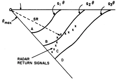
The sketch shown in Figure 1 illustrates the ~eneral
characteristics of the problem, along with certain of the key variables. As shown, the situation involves a high speed, low flying aircraft equipped with a ra-dar altimeter, and a rara-dar trained to search out ir-regularities in the terrain ahead. The antenna of this radar scans in the vertical plane with a typical maximum horizontal range of from 15 to 25 miles. The line of sight of the unstabilized antenna is a function of the pitch angle of the aircraft and the antenna angle. In Figure 1, (I is the angle between the horizontal and the line of sight, and h(t) is the aircraft altitude above mean sea level. The signals from the radar altimeter and the forward looking radar are used as inputs to a computer that calcu-lates control commands for the aircraft control system.
FIGURE 1: General Characteristics of Terrain Avoidance Problem.
A hypothetical system might be visualized to oper-ate as follows. The aircraft is required to fly as close to the ground as safety permits but no lower than three hundred feet above the terrain. The control system can respond to four commands:
standard rate climb, emergency climb, maintain altitude, and standard rate descent. If the aircraft altitude is between 300 and 400 feet the altimeter signals will not initate a climb command, but will over-ride a descent command. The return signals from the main radar signifying the slant range from the aircraft to the terrain ahead are compared by the control computer with three functions; gl(O), g2( 0), andg3(8). These functions depend upon the characteristics of the aircraft, the radar, and might even include some information regarding the expected feature s of the terrain. These functions define regions A, B, C, and D of Figure 2. Radar return signals falling in region D will call for a descent command, providing the· altimeter signal does not override it. Returns in region C call for
maintain alt.; in B the command is standard rate climb. Returns in region A cause an
emer-gency climb command. The priority of commands is evident. Since the radar returns occur faster than the control system can respond, it probably is necessary to perform some averaging or smooth-ing of the return signals. Possibly only the "worst"
FIGURE 2: Functions 'for Control Computer.
return signal from each full sweep of the antenna is used by the control computer.
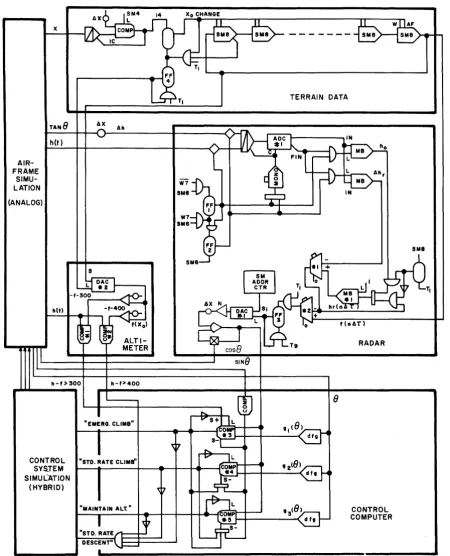
HYBRID SIMULATION WITH HYDAC
Figure 3 shows the overall program for the hybrid simulation of the system schematically. The air-craft dynamic behavior and the control system characteristic s are programmed in two
dimen-sions using conventional analog techniques. The program for representing the remaining portions of the system with the digital components of the HYDAC system (DOS) are shown with most of its detail in Figure 6.
The terrain profile, quantized at A x intervals, is stored as binary numbers in the Serial Memory (SM) Units of the DOS. Several hundred miles of terrain may be stored in these units; or, alterna-tively, 25 to 50 miles of terrain (only 15 to 25 miles of data is employed at one time for the radar simulation) might be stored in a smaller number of SM units, with the remainder of the terrain data stored on punched paper tape. In this case, as the
Xo TERRAIN DATA STORAGE
(DIGITAL)
AIRFRAME
1
fin tu. Xo)SIMULATION ho
(ANALOG) AhT
RADAR
f(Xo) SIMULATION
COIGITAL)
n"~1
ALTIMETER (HYBRID)TIl
cOlei
1"
hlt)-f(xo)
!
CONTROL CONTROL
SYSTEM COMPUTER
SIMULATION SIMULATION
(RYBRID) (HYBRID)
COMMANDS
FIGURE 3: Block Diagram of Program for
[image:2.612.325.520.46.179.2] [image:2.612.57.279.294.397.2] [image:2.612.315.523.496.699.2]simulation progresses the SM units would be up-dated from the paper tape to maintain the correct data always available to the program.
In formulating the program for the radar scanning of the terrain data· it should be remembered that , the correct starting point for the scanning process must be calculated continually. As the aircraft proceeds with a variable horizontal velocity its position along the x axis determines the starting point. Thus, every time the aircraft traverses a distance.1x, a new starting point in the sequence of terrain numbers is used in the radar simulation.
TERRAIN DATA STORAGE
The general scheme for storing the terrain data is illustrated by the DOS program shown in Figure 4. This program utilizes the SM-8 units (256 num-bers per unit) to store all terrain data. Flip-flop #1 (FF#l) is set each time the aircraft position x equals a multiple of.1 x* causing one data word to be passed forward from each SM unit to the next unit, all at the same time. The SM unit on the right side of the diagram holds all the data that is to be scanned by the radar simulation. The data word transferred out of that unit is passed back to the first unit to retain the entire terrain profile in storage for use in the next com-puter run. Thus, the terrain data is stored in a loop that is precessed at a rate proportional to the aircraft ground speed. This process goes on inde-pendent of the radar simulation program.
~---+-~
- OLD DATA WORD
TERRAIN DATA TO BE SCANNED BY RADAR
Figure 4: Digital Program for Terrain Storage Utilizing HYDAC Serial Memory Units.
RADAR SIMULATION
With each pulse of the radar transmitter a small "package" of electromagnetic energy follows a straight line path until it intercepts the ground surface. That action and the return propagation of the signal to the aircraft occur s in an interval of time that is negligible compared to the time of events in the real time simulation of the aircraft. The radar simulation should then determine the time of intercept of radar signals with the terrain in a very short time and at a high repetitive rate.
*This can be accomplished in a number of ways using either analog or digital components.
The repetition rate should be the pulse repetition frequency (prf) of the radar (0.2 to 10KC), and the calculation time ideally should be less than the radar return signal time: 12.36 microseconds per mile of slant range. In a practical simulation it is possible to relax these speCifications signifi-cantly without affecting the accuracy of the overall simulation.
A radar with a prf of 500 cps is assumed and sim-Ulated directly with the HYDAC system for purposes of illustration. Since the control computer program being examined does not calculate a control signal for every radar return signal but rather for the worst signal in a group, it is sufficient that the calculation of a radar return (slant range) be per-formed in the period allowed for each pulse; i.e.,
l/prf =·1/500 cps = 2 milliseconds. This is a con-venient choice for illustration since the SM-8 unit cycle time is 2 milliseconds, which means that all the data in one SM-8 unit can be scanned in this time. If the prf in an actual problem cannot be scaled or simply changed to 500 cps, 2KC, or 8KC (corresponding to the cycle time of. the SM-8, SM-6, and SM-4 units) then several variations of this program are available for simulation of speci-fic pulse repetition frequencies.
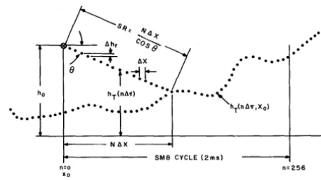
Consider the situation that exists for a single radar pulse. The altitude at the instant of transmission is ho, the angle of incidence (J, and T is the sweep time
of the radar, running from 0 to 2 milliseconds, repetitively. Let
a
hr =ax
tan (J be the change in altitude of a radar pulse while traversing a hori-zontal distance ~ x. Then with ~hr and ho heldconstant during a radar pulse the discrete func-tion hr (n.1T) is generated by successive subtrac-tions of ~hr from hr (initial value: ho), where
.1 T = 2 millisecond 7- 256 = 8 microseconds and n = 0,1,2, ... 255. This function is the line of sight path of a radar pulse, as shown in Figure 5, and is formed in a serial accumulator circuit (Adder -Subtractor #1 and Memory Buffer #1).
...
.
s~, N4
ah
r
co;.;
1
••• ---*. <7
/ • ...-;-t ax ••••••••
[image:3.620.335.564.581.710.2]e
··f.-;-II-
:
...
....
n=o Xo
..
..
.
.
hT(na11 . : : • • • • • • • • ,
• • • • • •• • •• _.- hr(nd'C'·,X o)
SMa CYCLE (2msl
n=256
AIR-FRAME
SIMU-LATION
(ANALOG) x
h(t)
1I(t)
lI-f>300
6X
S 611
ALTI-METER
"EMERa. CL.IMB"
CONTROL "STD. RATE CL.IMB"
SYSJEM SIMUL"'ATiON
(HYBRID)
TERRAIN DATA
8
CONTROL COMPUTER
FIGURE 6: HYDAC Program for Terrain Avoidance Simulation.
[image:4.615.72.523.112.668.2]The analog voltages representing h(t) and 6h are switched into a Track-Store amplifier for conver-sion by ADC#l in the program for simulating the radar (Figure 6). The voltage h(t) is converted first, being gated by FF#l; then 6h is gated by FF#2. Both conversions take place in the 0,5 millisecond period just prior to the radar pulse initiation. Since ~ hr changes rapidly, the accuracy of the simulation depends on using the latest possible value of ~hr just prior to the radar pulse initiation time. These two binary numbers are held constant in Memory Buffer Units during the time for one radar pulse (2 milliseconds).
The detection of intercept of the slant range with the ground is achieved by successive digital com-parisons (Adder-Subtractor #2) of hr(n~T) with the stored terrain data until the difference f(n~ T ,xo) -hr(n~T) has a negative sign. Variable f(n.1r ,xo)
is the terrain data for a particular initial position xo, over the range of naT. When intercept occurs the sign of the result of the comparison is used to gate (FF#3) the address of the Serial Memory Timer Unit* into DAC#l, thus identifying the number of the data samples along the x axis at which inter-cept occurred. If the SM address is N, then the ground range of the intercept i s N~x and the slant range is SR
=
cos 8 + N6x. A value of SR is de-termined for each radar pulse, every 2 milli-seconds,RADAR ALTIMETER
After the terrain data is updated for a new value of Xo FF4 is set to load the new f(xo) into a digital-to-analog converter (DAC #2). The altimeter is simulated then by comparison of altitude, h(t) , with the limits f(xo) + 300 (Comparator #1) and f(xo) + 400 (Comparator #2). If h(t) - f(xo) <400 any descent command is inhibited (Gate #1). If h(t) - f(xo)
<
300', an emergency climb command is given (Comparator #3).CONTROL COMPUTER
The control computer simulation is accomplished by storing gl (8), g2(O), and g3(8) in diode function generators and comparing the functions with the slant range (Comparators #3, #4, #5). The control commands are formed by logic from the com-parator outputs and the altimeter comcom-parator out-puts. When sin () goes to zero, once each antenna cycle, the signals stored in the comparator output flip-flops are cancelled and the averaging process for one antenna cycle starts again.
*Serial memory time addresses are terminated as an eight bit word on the standard DOS patch panel.
PROGRAM REFINEMENTS
If the terrain data quantization is coarse (large
~x) it may be necessary to interpolate at the be-ginning and end of the slant range calculation. At the start of the r ad a r sweep a thi rd number,
~ho(t) = [x(t) - xo] tan 8 is converted by ADC #1
and used as the first increment: hr C~r, xo) =
hr (xo) - ho (t) and the usual &1
=
~x tan 8 is used thereafter, After intercept with the terrain func-tion it is possible to interpolate between terrain data points to obtain a more accurate va·lue of slant range,The terrain data has been represented by standard DOS words; i.e., a 16 bit binary word in the hypo-thetical example presented. However, since the ter-rain data used in a practical simulation is not likely to be very precise (nor need it be) it may be convenient to represent each data point with an 8 bit word and store two data points in each DOS word storage position, thereby doubling the capacity of a given number of units. This does not reduce the cycle time of an SM-8 unit but may permit use of a smaller SM unit, or else the doubling of the storage of the data in the output SM unit, to permit simulation of a higher radar pulse repetition frequency.
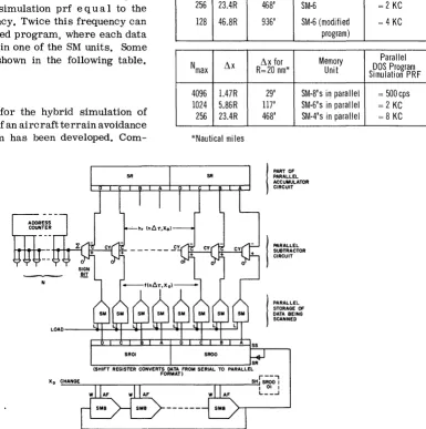
If extremely fast simulation (faster than real time) is required, or if accurate representation of a very high radar prf (say 10KC) , together with a small value of 6 x, is necessary, or if the max-imum range of the radar is large, then a higher rate is needed in the generation and comparison of f(n6T,xo) than described above. The compari-son rate in the example d-escribed is about one every 8 microseconds, or 131,072 comparisons per second. This rate can be increased to 220 or about 106 comparisons per second with addition of more HYDAC components. The DOS program shown in Figure 6 is modified by arrangi!lg the data words that are scanned by the simulated radar in a parallel format. Thus all eight bits of a data word are available at once, in Figure 7. In addi-tion, the two serial Adder-Subtractors are replaced each by eight such units connected to form parallel subtractors (only one is shown in Figure 7). Notice that only the "sign bit" output of this circuit is required; this again gates N from the Serial Memory Address Counter of the DOS.
prf ~
12.36R
where R is in nautical miles. If R is quantized into Nmax increments of size Ll x feet then,
prf ~ 6000
12. 36Nmax
An approximation is necessary since the radar simulation calculation cannot be performed at the high speeds and resolution accomplished by the electromagnetic energy of the radar. Either the prf and R are chosen to be equal to the actual values of the radar and the resulting Llx accepted, or one se-lects the desired resolution of Llx over the range R and then employs a simulation prf e qua I to the SM unit cycle frequency. Twice this frequency can be had with a modified program, where each data word is stored twice in one of the SM units. Some of the choices are shown in the following table.
CONCLUSIONS
A general program for the hybrid simulation of a hypothetical study of an aircraft terrain avoidance flight control system has been developed.
Com-puter circuits and diagrams for the digital and hybrid portions of the program utilizing the general purpose components of the HYDAC Computer have been presented. These circuits illustrate the ease with which the building block design of the HYDAC components lend themself to the formulation ofhy-brid simulation programs. In addition, comments are made regarding the extension of the general program to actual situations.
Nmax ~x
512 16.7R
256 23.4R
256 23.4R
128 46.8R
Nmax ~x
4096 1.47R 1024 5.86R 256 23.4R
*Nautical mi les
SROO
~x for
R=20 nm* Memory Unit
234' SM-8 (Fig. 6)
468' SM-8 (modified program)
468' SM-6
936' SM-6 (modified program)
~x for Memory R=20 nm* Unit
SS
29' SM-8's in parallel 117' SM-6's in parallel 468' SM-4's in parallel
I
PART OF PARALLEL ACCUMULATOR CIRCUITI
PARALLELSUIiTRACTOR CIRCUIT
I
PARALLELSTORAGE OF DATA BEING SCANNED
Serial DOS Program
8 bit data Simulation PRF
= 500 cps
= 1 KG
= 2 KG
= 4 KG
Parallel DOS Program Simulation PRF
= 500 cps = 2 KG = 8 KG
'-:-(S-H ... IFT-R-E-GIS--T=ER-C ... ON-V.",.ER--TS-DA..L."' ... A .... FR--O-M -SE-R-IAL-T-O-P-AR-A---!LLE~R
Xo CHANGE
FORMAT)
r--"
SH SROO I I 01 I L __ .J
[image:6.613.148.533.272.659.2]EAI
®ELECTRONIC ASSOCIATES, INC. Long Branch, New Jersey