A b s t r a c t. The paper presents a method for the estimation of variability of soil bulk density and of variability of infiltration rate on the basis of easily determinable variability of soil moisture. First, the author put forth the hypothesis that variance of both of the estimated parameters is directly proportional to variance of soil moisture. The hypothesis was then verified for both of the estima-ted parameters on the basis of a field experiment conducestima-ted on a grass-land object situated in the locality of Silna Wrony, Wielkopolskie Province, Poland. Independent experimental material obtained from research on another object situated in the locality of Sucha Rzeczka, Warmiñsko-Mazurskie Province, Poland, permitted com-parative analysis of measured data and data obtained on the basis of the estimations. Data obtained on the basis of the experiment permitted only to compare the estimated variance of infiltration rate with the variance obtained on the basis of direct measurements. The estimated value of variance of infiltration rate differed from the variance obtained from measurements by a maximum of 6.8%.
K e y w o r d s: soil moisture, soil bulk density, infiltration rate, TDR technique
INTRODUCTION
Water movement in porous media – including soil – takes place in accordance with strict laws of physics as written by constitutive equations (Reinhard, 1992; Walczak et al., 1998). The equations include coefficients determining the area under study. The coefficients are determined on the basis of measurements, which is always burdened with errors. Likewise, measurements are the basis for the determination of conditions characterizing phenomena on the border of the area described, as well as the initial condition. Moreover, soil as a porous medium formed by the nature is
characte-rized by considerable variability even when it is classified as homogeneous by the soil scientists (Brandyk et al., 1993; Peck, 1983; Warrick and Nielsen, 1980; Webster and Oliver, 1990). In view of those facts, the coefficients and the initial and border conditions should not be assigned strictly defined values, but they should be expressed as random variables (Russo, 1998; Sobczyk, 1996). The Richards equation will be better suited for the modelling of water movement in soil if it is treated as a stochastic differential equation.
Determination of the randomness of the physical features of soils that are also coefficients for the Richards equation is very tedious. Therefore, the objective of the study presented herein is to propose a method for the estima-tion of variability of two selected parameters of soil – bulk density and infiltration rate - on the basis of soil moisture variability which is easy to determine.
METHOD AND DESCRIPTION OF THE EXPERIMENT
In an earlier paper the author presented an unverified hypothesis that assumed linear relationship between varia-bility of soil moisture and variavaria-bility of selected physical properties of soil (Janik, 2005a). The hypothesis related to an area in which ground water level is the same at every point. This ensures capillary rise water supply that is uni-form at a given depth over the area. In the case of the precipi-tation-type water economy, the ground water table is located so deep that it has no effect on the moisture of the surface layer of soil. Moreover, it is required that the area under analysis be characterized by uniform vegetation eg crop culture and uniform atmospheric conditions (precipitation, insolation, wind, temperature), which ensures uniform net
Spatial variability of soil moisture as information on variability
of selected physical properties of soil*
G. Janik
Institute of Development and Protection of Environment, Wroc³aw University of Environmental and Life Sciences Plac Grunwaldzki 24, 50-363 Wroc³aw, Poland
Received August 6, 2007; accepted December 19, 2007
© 2008 Institute of Agrophysics, Polish Academy of Sciences Corresponding author’s e-mail: [email protected]
*The experiment was conducted with students from Prof. S. Bac Students’ Science Organization.
A
A
Agggrrroooppphhyhyysssiiicccsss
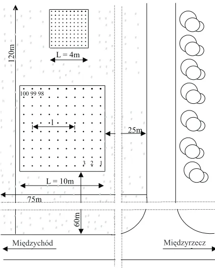
intensity of precipitation at every point of the area. If the above conditions are met, possible differentiation in mois-ture at a constant depth may be due only to differentiation in those physical properties of the soil that affect the soil mois-ture. Hence the grounds for the above hypothesis. To verify the hypothesis, a field experiment was carried out on a grass-land object situated in the locality of Silna-Wrony in the Wielkopolskie Province. On the experimental plot 200 points were selected, located at the depth of 10 cm below the ground surface, distributed in a regular pattern within two squares with surface areas of 16 m2and 100 m2. At each of the points simultaneous determinations were made of the soil moisture, dry bulk density, and infiltration rate. A site plan of the experimental plots, with the distribution of the measurement points shown, is presented in Fig. 1. Soil moisture measurements were taken using the D-LOG/ms field apparatus (Malicki, 1990). Figure 2 presents the geo-metry of TDR probe placement in the soil profile so that the centre point of the rods is located at the depth of 10 cm beneath the soil surface.The infiltration rate determined on the basis of the field experiment was adopted as an index of the conditions of infiltration rate. At each measurement point a test pit was made, with a diameter ofÆ5 cm and a depth of 10 cm (Fig. 3) (Kowalski, 1998). The pit walls were strengthe-ned with PVC tube, inserted down to the depth of 10 cm from the soil surface. The bottom of each pit was covered with a 2 cm layer of gravel for protection against washing away and/or accumulation of mud. At the start of the experiment each pit was filled with water up to the level of the soil surface. Subsequently, water was added so as to keep the height of the water column constant. The experiment was con-ducted until stabilized conditions were achieved. The volu-me of water used for the topping up, referenced to tivolu-me, provi-ded the rate of infiltration through the bottom of the test pits.
After the determinations of soil moisture and infiltration rate, the strengthening tubes were removed from the test pits and soil samples were taken into cylinders of 100 cm3in volume. The samples were dried at 105°C and, after weigh-ing, the soil bulk density was calculated. The exact location of the sampling points is shown in Fig. 3.
Statistical analysis of the measurements of moisture, bulk density and infiltration rate was performed in three ways. First to be performed was the analysis of stability of classic statistical measures with relation to the number of observations. This was done using random sampling proce-dures written by means of the Mat-Lab software (Janik, 2005b). The procedures permitted the calculation of the mean values, variance, skewness and kurtosis for increasing values of the number (n) of samples, separately for the set of moisture data, bulk density data, and infiltration rate data. The calculations were made by sampling values, starting with 10, then 11, 12 and on up to 200.
100 99 98
3 2 1
L = 10m L = 4m
120m
Miêdzychód Miêdzyrzecz
25m
60m
75m l
Fig. 1.Distribution of measurement points.
i-th measurement point
10 cm
5 cm 5 cm
α= 45o
TDR probe
.
Fig. 2.Geometry of TDR probe placement in the soil.
i-th measurement point
10
cm
.
15
cm
cylinder – 100 cm3
5cm gravel layer – 2cm
PVC cylinder
Fig. 3.Measurement of infiltration rate and placement of the cylin-der for soil bulk density determination.
The second method of statistical evaluation of measure-ment data was variogram analysis (Greenholtzet al., 1988; Gregoet al., 2006; Issaks and Srivastava, 1998; Mohantyet al., 2000; Usowicz, 1999). Variograms are functions expressing the relation of variance of the analysed feature and the distance between the compared points. As an example, the moisture variogram was expressed with the relation:
(
)
gq( ) qi q
( ) ( ) l
m l i i l
m l
= å - +
=
1 2
2
1
, (1)
where: gq( )l – variogram of moisture, (m3m-3)2; m(l) – number of compared pairs of points separated from each other by distance,l(-);l– distance between the compared points, (m),qi– value of moisture at the i-th point, (m3m-3); qi+l– moisture at the point located at distancelfrom the i-th point, (m3m-3).
Analysis was also performed for standardized variograms that are used when the calculated values of semi-variance are so scattered that it is difficult to find a fitting mathematical model (Keimet al., 2005; Usowicz and Usowicz, 2004). Both types of semivariograms were built on the basis of measured data and of data with the square trend removed. Calculations were made using the Surfer 8 software.
The third stage of statistical analysis consisted in exami-ning the relation between the variance of soil moisture, variance of bulk density and variance of infiltration rate as related to the logarithm from the area for which those va-riances were determined. If the relations prove to be linear, the relation of the variance of soil bulk density with the va-riance of infiltration rate will be linear. To determine the equation of such a line it is enough to give the variance of the selected parameter of the soil and the variance of moisture for two freely chosen areas (preferably the smallest and the largest). The equation will permit the estimation of the variance of the selected soil parameter on the basis of the easily determinable variance of soil moisture without the necessity of performing numerous labour-consuming tests and determinations.
A comparative analysis of data estimated according to the proposed method and data obtained on the basis of direct measurements was made for one parameter only – the infil-tration rate. To this end another experiment was conducted, on another grassland object located in the village of Sucha Rzeczka in the Warmiñsko-Mazurskie Province. Determi-nations of bulk density and infiltration rate were made at 100 points distributed evenly over an area of 25 x 25 m. The measurements were made following the same method as that applied on the object at Silna-Wrony.
RESULTS AND DISCUSSION
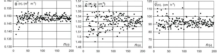
Let us first analyse the measurement data obtained from the experiment performed on the object at Silna Wrony. Figure 4 presents the runs of the calculated mean values – of moisture, bulk density and infiltration rate – with relation to the number of measurements (n) on the basis of which the mean values were determined. From the figure we can read the minimum number of measurements needed for the calcu-lated mean values to be determined with the required accu-racy. As an example, when mean moisture is determined for a small number of measurementseg nbetween 10 and 20, its value may vary within the range from 0.135 to 0.155 m3m-3. Whennis at least 30, the calculated mean value will vary only from 0.145 to 0.155 m3m-3. In this case further increase of the numbernis not justified as it does not improve the accuracy of the calculations (the mean is stabilised for n=30). Calculated mean values of bulk density and infiltra-tion rate stabilise uniformly. This means that it is difficult to positively indicate a value of the number n above which there would be no significant improvement in the accuracy of the calculations. In this case, as the criterion of selection of the numbern, we should adopt the required level of accu-racy of determination of the mean value. As an example, for the mean bulk density to be calculated with the accuracy of ± 0.01 g cm-3it is necessary to perform about 150 determi-nations of the feature under analysis. The value of mean bulk
0.130 0.135 0.140 0.145 0.150 0.155 0.160
0 50 100 150 200
n(-) (n), (m3 m-3)
θ
1.48 1.49 1.5 1.51 1.52 1.53 1.54 1.55 1.56 1.57
0 50 100 150 200
(n), (g cm-3)
n(-)
ρ
60 70 80 90 100 110 120
0 50 100 150 200
q(n), (cm h-1)
n(-)
Fig. 4.Stability of mean: moisture –q( )n, soil bulk density –r( )n, rate of infiltration –q n( );n– number of random-sampled measurement points (object at Silna-Wrony).
Stability
of
mean
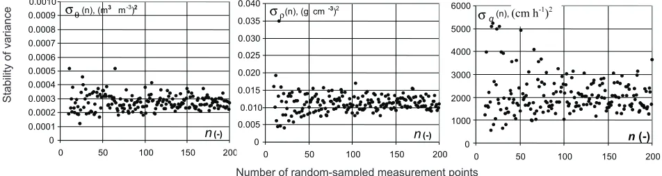
density is then 1.53 ± 0.01 g cm-3. At the same time, for n=150 the mean value of the infiltration rate is 100 cm h-1 ± 15 cm h-1. Analysis of variance stability is presented in Fig. 5. As can be read from the figure, in the case of moisture variance and bulk density variance, increase in the number of determinations above 50 does not result in any significant improvement in the accuracy of the calculations (the value of variance is stabilised forn=50). Whereas, the variance of
infiltration rate stabilises not earlier than at n=100. The indexes of asymmetry, the values of which are presented in Fig. 6, stabilise uniformly in every case, and as the criterion of choice we should adopt the required accuracy of calculations. As an example, for n>100 the index of asymmetry for moisture will vary within the range from -1 to 0, for bulk density from –1.5 to +0.8, while for infiltration rate – from 1 to 3. The rate of kurtosis stabilisation (Fig. 7) is
0 0.0001 0.0002 0.0003 0.0004 0.0005 0.0006 0.0007 0.0008 0.0009 0.0010
0 50 100 150 200
n(-)
σθ(n), (m3 m-3)2
0 0.005 0.010 0.015 0.020 0.025 0.030 0.035 0.040
0 50 100 150 200
(n), (g cm-3)2
n(-) σρ 0 1000 2000 3000 4000 5000 6000
0 50 100 150 200
(n), (g3. cm-3)2
n(-)
σq (cm h-1)2
Fig. 5.Stability of the variance of: moisture –sq( )n, soil bulk density –sr( )n, rate of infiltration –sq( );n n– number of random-sampled measurement points (object at Silna-Wrony).
-3 -2 -1 0 1 2 3 4 5 6 n(-)
Αθ(n), (-)
-3 -2 -1 0 1 2 3 4 5 6
0 50 100 150 200
n(-)
Αρ(n), (-)
-3 -2 -1 0 1 2 3 4 5 6 n(-)
Αq(n), (-)
0 50 100 150 200 0 50 100 150 200
0 50 100 150 200
Fig. 6.Stability of asymmetry index calculated for: moisture –A nq( ), soil bulk density – A nr( ), rate of infiltration –A nq( );n– number of random-sampled measurement points (object at Silna-Wrony).
0 2 4 6 8 10 12 14 16 18 20
0 50 100 150 200
n(-)
Κθ(n), (-)
0 2 4 6 8 10 12 14 16 18 20
0 50 100 150 200
n(-)
Κρ(n), (-)
0 2 4 6 8 10 12 14 16 18 20
0 50 100 150 200
n(-)
Κq(n), (-)
Fig. 7.Stability of kurtosis calculated for: moisture –Kq( ), soil bulk density –n K nr( ), rate of infiltration –K nq( );n– number of random-sampled measurement points (object at Silna-Wrony).
Stability
of
variance
Number of random-sampled measurement points
Number of random-sampled measurement points
Stability
of
asymmetry
index
Number of random-sampled measurement points
Stability
of
slow and even forntending to 200 one should be aware that its value may vary – for moisture within the range from 2 to 6, for bulk density from 4 to 6, and for infiltration rate from 2.5 to 12. Table 1 presents the minimum and maximum values of statistical parameters calculated for moisture, bulk density and infiltration rate. Extreme values were selected first fornwithin the range from 5 to 50, then fornfrom the range of 50 to 150, and finally fornwithin the range from 150 to 200. For each pair of maximum and minimum values, intervals were calculated, defined as absolute values of their difference. In all the cases the values of the intervals de-creased with increasing value of the numbern. This con-mfirms the increase in the accuracy of calculation of the mean values, variance, asymmetry and kurtosis with increa-sing value of the numbern. As an example, whennis within the range from 5 to 50, the interval of the mean moisture is 0.015 m3m-3and whenn>150 the interval is only 0.004 m3 m-3. For the estimation of the symmetry of distribution of moisture, bulk density and infiltration rate, analysis of skewness indexes was applied, the values of which – calculated for 5>n³200 – are also presented in Table 1. Negative values of skewness indexes calculated for moisture and bulk density indicate left-sided asymmetry. This fact is related to the occurrence of non-homogeneity of the soil in the form of macropores. In such a case, when
determination of moisture or bulk density is made at a point of occurrence of a macropore, both moisture and bulk density may assume values notably lower than the mean values. Right-sided asymmetry occurs for the infiltration rate (skewness greater than 0). This should also be attributed to the occurrence of empty spaces in the soil. In such a case, at points of macropore occurrence the infiltration rate may assume values considerably higher than the mean value. This is due to so-called preferential flow of water in the soil. As no studies were made on the distribution of macropores, this statement should be considered as an unverified work-ing hypothesis. The index of kurtosis (k), decidedly the highest in the case of infiltration rate, described the con-centration of values with relation to the mean value (when k>3 the distribution is more slender than normal).
Next, analysis of the data was performed with the help of geostatistical methods. Calculated values of semivariance from the classic equation (relation 1) are, in the case under consideration, so scattered that it is difficult to fit a mathe-matical model to them. Better fitting was obtained using standardized semivariograms. The quality of fitting of ma-thematical models to empirical data was determined using the coefficient of determination R2. Figures 8, 9, and 10 pre-sent standardized semivariograms of moisture, bulk density and infiltration rate built on the basis of measurement data
Parameters
Moisture Bulk density Rate of infiltration
min max interval
(|max-min|)
min max interval
(|max-min|)
min max interval
(|max-min|)
Mean (m3m-3) (g cm-3) (cm h-1)
5<n£50 0.138 0.153 0.015 1.49 1.56 0.07 78 120 42
50<n£150 0.146 0.153 0.007 1.50 1.55 0.05 83 120 37
150<n£2000 0.147 0.151 0.004 1.51 1.54 0.03 85 115 30
Variance (m3m-3)2 (g cm-3)2 (cm h-1)2
5<n£50 1.2 10-4 5.2 10-4 4.0 10-4 4.9 10-4 20 10-4 15.1 10-4 500 5300 4800
50<n£150 1.8 10-4 5.2 10-4 3.5 10-4 7 10-4 16 10-4 9 10-4 1000 4000 3000
150<n£2000 2.0 10-4 1.2 10-4 1.8 10-4 10 10-4 15 10-4 5 10-4 1300 3500 2200
Skewness (–) (–) (–)
5<n£50 -2.2 1 3.2 -2 0.2 2.2 0 3.5 3.5
50<n£150 -1.8 0.4 1.4 -1.5 0.1 1.6 0.7 3.0 2.3
150<n£2000 -1.1 0 1.1 -1.2 -0.7 0.5 0.8 2.8 2.0
Kurtosis (–) (–) (–)
5<n£50 1.5 7 5.5 2 -11 9 1.8 19 17.2
50<n£150 1.8 7 5.2 2.1 -8.2 7.1 2.3 19 16.7
150<n£2000 2.1 6.2 4.1 2.9 -5.8 2.9 3.1 16 12.9
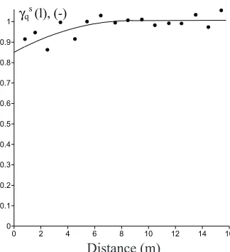
with the square trend removed. The mutual situation of the measurement points permitted the building of semivario-grams forlmax=16 m. To each standardized semivariogram a mathematical model was fitted, the parameters of which are given in Table 2. Within the range under consideration (for l<16.0 m) the existence of spatial variability of the values considered was observed. For soil moisture and bulk density the best-fitted model is the spherical model, and in the case of infiltration rate – the quadratic model. In every case the nugget effect was observed, the value of which provides information on the variation of the studied parameter for distances smaller than the minimum sampling step. The smallest variation was noted in the case of bulk density of the soil, at 0.728, whereas in the case of soil moisture and infiltration rate the values of the nugget effect were similar at 0.841 and 0.851, respectively. The sill values varied only within the range from 1.016 to 1.039. The maximum value was recorded for bulk density, and the minimum for infiltration rate. This means that the maximum variation was the greatest for bulk density and the least for
γθs(l), (-)
0 2 4 6 8 10 12 14 16 0
0.2 0.4 0.6 0.8 1 1.2
l (m)
Fig. 8. Standardized semivariograms of moisture content and mathematical model,gqs– standardized semivariogram (data with square trend removed),l– distance.
γρs(l), (-)
0 2 4 6 8 10 12 14 16 0
0.1 0.2 0.3 0.4 0.5 0.6 0.7 0.8 0.9 1 1.1
l (m)
Fig. 9.Semivariograms of soil bulk density,gsr – standardized semivariogram (data with square trend removed),l– distance.
γqs(l), (-)
0 2 4 6 8 10 12 14 16 0
0.1 0.2 0.3 0.4 0.5 0.6 0.7 0.8 0.9 1
l (m)
Fig. 10. Semivariograms of infiltration rate,gqs – standardized semivariogram (data with square trend removed),l– distance.
Soil properties Model Mugget
(-)
Sill (-)
Range (m)
Anisotropy ratio
(-)
Anisotropy angle
(o)
Moisture spherical 0.841 1.029 2.95 2 166.8
Bulk density spherical 0.728 1.039 5.59 2 48.8
Rate of
infiltration quadratic 0.851 1.016 7.95 2 35.56
T a b l e 2.Parameters of standardized semivariograms plotted for moisture content, bulk density, and infiltration rate
Distance (m) Distance (m)
infiltration rate. What turned out to be more varied was the ranges of spatial variability of the estimated soil parameters. The value of the range defines such a limit value of l, the exceeding of which does not cause significant changes in the variance of the studied parameter. The greatest range value was obtained in the case of infiltration rate, equal to 7.95 m, while the lowest was that for soil moisture, at 2.95 m. In every case a gentle anisotropy was observed in the data distribution. Preferential directions of the anisotropy after the introduction of standardization of semivariograms were 166.8for soil moisture, 48.8for bulk density, and 35.6for infiltration rate.
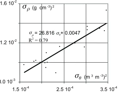
Subsequent statistical analyses were conducted by studying the values of variance of the parameter under ana-lysis in relation to the logarithm from the area on the basis of which the variance was determined. Figure 11 presents the variability of variance of bulk moisture and infiltration rate in relation to the logarithm from the area for which they were determined. The relations are linear. This means that va-riance of bulk density and vava-riance of infiltration rate are
dependent on variance of soil moisture in a linear manner, which is illustrated in Figs 10 and 12. It is, therefore, possi-ble to estimate the variance of a selected parameter within its whole range of variability, knowing only its value for two cor-responding variances of moisture. The values of the coeffi-cient of regression for the linear relations presented in Fig. 11 are, respectively, 0.70 for variance of moisture, 0.36 for variance of bulk density, and 0.49 for variance of infiltration rate. Whereas, the regression coefficients for the data pre-sented in Figs 12 and 13 are greater and amount to, respecti-vely, 0.79 for variance of bulk density and 0.75 for variance of infiltration rate. Therefore, it is better to estimate the variance of the parameters under analysis on the basis of variance of soil moisture and not on the basis of logarithm from the area. Figure 14 was created as a result of the experiment conducted on the object at Sucha Rzeczka. The information presented in the Figure constitutes the basis for comparative analysis of values estimated by means of the proposed method and of data obtained on the basis of measurements. In the figure, the first to be plotted on the
R2= 0.36
2 0.00008
0.00016 0.00024 0.00032 0.0004
-1 0 1 2
log10f(-)
sq(log10f), (m3m-3)2
sq= 7 10-5log10f+0.0002
R2= 0.70
1000 1500 2000 2500 3000
-1 0 1 2
log10f(-)
sr= 284.71log10f+1768.7 sr(log10f), (g3cm-3)2
0.008 0.01 0.012 0.014 0.016
-1 0 1
sq(log10f), (cm h-1)2
sq= 0.0017log10f+0.0099 R2= 0.49
log10f(-)
Fig. 11.Variance of moisture –sq(log )f , bulk density –sr(log )f , and rate of infiltration –sq(log ) in relation to logarithm of the areaf
under study,f– area for which the variance was calculated (object at Silna-Wrony).
sq= 5 10-6s
q+ 756.98
1.50 10-3 2.00 10-3 2.50 10-3
1.5 10-4 2.5 10-4 3.5 10-4
s
q(m3m-3)2s
q (cm h-1)2R2= 0.74
Fig. 13.Variance of infiltration ratesqin relation to variance of moisturesq(object at Silna-Wrony).
sr= 26.816sq+ 0.0047
8.0 10-3 1.2 10-2 1.6 10-2
1.5 10-4 2.5 10-4 3.5 10-4
s
q (m3m-3)2s
r(g cm-3)2R2= 0.79
graphs were two points with coordinates (óqmin,óqmin) and (óqmax,óqmax) that were obtained on the basis of measure-ment data. The point with coordinates (óèmin,óqmin) was ge-nerated on the basis of measurements on areafmin= 56.25 m2 (square of 7.5 x 7.5 m ), while the point with coordinates (óèmax,óqmax) on the basis of measurements on areafmax= 506.25 m2(square of 22.5 x 22.5 m). The two points define the line óq(óè). Next to be plotted were points with coordinates (óè1,óqz1) and (óè2,óqz2) obtained on the basis of measurements for areaf1=156 m2(square of 12.5 x 12.5 m) and area f2= 306.25 m2(square of 17.5 x 17.5 m). The values of varianceóqz1,óqz2were then compared with the values
óqs1,óqs2 determined from the line óq(óè). The value of varianceóqs1estimated in this manner differs from the value
óqz1obtained on the basis of measurements by only 0.3%. Whereas, the estimated variance óqs2 is greater than the varianceóqz2by only 6.8%.
CONCLUSIONS
1. The occurrence of spatial variability of soil moisture by volume, bulk density and infiltration rate was observed. The soil moisture by volume and bulk density were characterized by spherical relation, while the infiltration rate followed the quadratic relation pattern. Maximum variation was the greatest for bulk density and the lowest for infiltration rate. The ranges of variability are more diverse – the greatest for infiltration rate and the smallest for soil moisture.
2. It is shown that in the surface layer of the grassland object studied the variance of soil bulk density and the variance of infiltration rate are directly proportional to the variance of moisture.
3. The study confirmed the applicability of the proposed method permitting the estimation of the variance of selected parameters of soil on the basis of the variance of soil moisture. In the case of estimation of the variance of infiltration rate the difference between the estimated values and those obtained on the basis of measurements was less than 6.8%.
REFERENCES
Brandyk T., Sk¹pski K., and Szaty³owicz J., 1993. Spatial variability in soil physical properties (in Polish). In: Recent Melioration Problems (Ed. C. Somorowski). SGGW Press, Warsaw, Poland.
Greenholtz D.E., Jim Yeh T.C., Nasch S.B., and Wierenga P.J., 1988.Geostatistical analysis of soil hydrologic properties in a field plot. J. Contam. Hydrol., 3, 227-250.
Grego R.C., Vieira S.R., Antonio A.M., and Della Rosa S.K., 2006.Geostatistitical analysis for soil moisture content un-der the no tillage cropping system. Sci. Agric. (Piracicaba, Braz.), 63, 4, 341-350.
Isaaks E.H. and Srivastava R.M., 1998. Spatial continuity measures for probabilistic and deterministic geostatistics. Math. Geology, 20, 4, 313-341.
Janik G., 2005a.Spatial variability of soil moisture in grassland. Int. Agrophysics, 19, 37-45.
σq= 1 10-7σθ+ 1907.7
3.5 10-3 4.5 10-3 5.5 10-3
1.6 10-4 1.8 10-4 2.0 10-4 2.2 10-4 σθ (m3m-3)2 σq (cm h-1)2
(σθmin, σqmin)
(σθmax, σqmax) (σθ2 ,σqs2 )
(σθ2 ,σqz2 ) (σθ1 ,σqz1)
(σθ1 ,σqs1)
Fig. 14. Comparison of variance of infiltration rate in the object at Sucha Rzeczka, estimated and determined on the basis of measurements;óè1,óè2– variance of soil moisture determined for areasf1andf2, óqs1,óqs2– estimated variance of infiltration rate
determined for areasf1andf2,óqs1,óqs2– estimated variance of infiltration rate determined on the basis of measurements for areasfmaxand fmin,(óèmin,óqmin) (óèmax,óqmax)– coordinates of points on the basis of which the lineóq(óè)was defined.
Variance
of
óq
Janik G., 2005b.Accuracy of determining distribution of the top soil layer moisture depending on the amount of observations (in Polish). Zesz. Nauk. AR Cracow, 420, In¿. Œrod., 26, 127-137.
Keim R.F., Skaugst A.E. and Weiler M., 2005. Temporal persistence of spatial patterns in throughfall. J. Hydrol., 314, 1-4, 263-274.
Kowalski J., 1998.Hydrology with Fundamentals of Geology (in Polish). University of Agriculture Press, Wroc³aw, Poland.
Malicki M.A., 1990.Reflectometric (TDR) meter of moisture content in soils and other capillary-porous materials. Zesz. Probl. Post Nauk Roln., 388, 107-114.
Mohanty B.P., Skaggs T.H., and Famiglietti S.J., 2000.Analysis and mapping of field-scale soil moisture variability using high-based data during the Southern Great Plains. (SGP97) Hydrology Experiment. Water Resour. Res., 36, 4, 1023- 1031.
Peck A.J., 1983.Field Variability of Soil Physical Properties. In: Advances in Irrigation (Ed. D. Hillel), Academic Press, New York.
Reinhard A., 1992.Soil and ground water movements in satura-tion and aerasatura-tion zones under different weather condisatura-tions as the effects of the drainage system applied (in Polish). Annals Agric. Univ., Wroc³aw, 103, l- 87.
Russo D., 1998.Stochastic analysis of flow and transport in un-saturated heterogeneous porous formation: effects of varia-bility in water saturation. Water Resour. Res., 34, 569-581.
Sobczyk K., 1996.Stochastic Differential Equation, Theory and Applications (in Polish). Science-Technics Press, Warsaw, Poland.
Usowicz B., 1999.Application of geostatistical analysis and fractal theory for the investigation of moisture dynamics in soil profile of cultivated field (in Polish). Acta Agrophysica, 22, 229-243.
Usowicz B. and Usowicz £., 2004.Point measurements of soil water content and its spatial distribution in cultivated fields (in Polish). Acta Agrophysica, 4(2), 573-588.
Walczak R.T., S³awiñski C., Sobczuk H.A., and Gliñski J., 1998. The hydrological aspect in the EURO-ACCES model (Agroclimatic change and European soil suitability) (in Polish). Acta Agrophysica, 9, 26-27.
Warrick A. And Nielsen D.R., 1980.Spatial Variability of Physi-cal Properties in the Field. In: Applications of Soil Physics (Ed. D. Hillel), Academic Press, New York.