International Journal of New Innovations in Engineering and Technology (IJNIET)
Vol. 1 Issue 4 April 2013 7 ISSN: 2319-6319
Model of Crisis Management Information
System
Dinesh Kumar
Research Scholar, Sai Nath University, Ranchi, India
Dr. Anuj Kumar Sharma
Associate Professor, OITM, Hisar, India
Abstract - The nature and complexity of crisis management has grown significantly in the past decade. Along with this growth, there is an even greater growth in technological solutions and aids. Computers have been used for crisis planning, regulatory compliance, response to disaster situations, and recovery. Even application forms for disaster assistance have become electronic instruments. This paper provides the procedure of computer technology used in crisis management. The Crisis Management Information System (CMIS) is a consolidated Computer Aided Dispatch (CAD) system that combines crisis centres, and medical dispatch services with modern Geographical Information System (GIS) real-time services (such as address verification, automatic vehicle location, automatic vehicle recommendation and routing, map displays) and online GIS updating to enhance crisis response. CMIS operates out of Regional Dispatch Centres which are communicating with responders via radios and mobile data computers in crisis vehicles. Implementation of CMIS provides an integratable, scalable crisis management system to support crisis responders.
Keywords— Automatic Location Identification, Crisis Management Information System, Computer Aided Dispatch, Network Analyst, Tracking Analyst,
I. INTRODUCTION
Crisis Management Information System (CMIS) is a computer database for disaster response that provides graphical, real-time information to responders. The purpose of the paper is to focus on how to implement the most recent technologies to improve the performance of the Crisis Life Cycle (CLC). Disasters pose many obstacles for integrating and coordinating crisis operations, especially when essential crisis management staffs are prevented from reaching designated crisis operations centres. The goal of this project is to build a reliable, scalable and full connectivity infrastructure to be used in future. Besides this, project will apply intelligent decision support system in order to enhance business processes and workflows. The project will include; (1) a complete computerized incident command system; (2) a computerized system for Electronic Patient Care Reporting (ePCR), (3) a monitoring system in the central operation room. The paper is organized as following. Section II describes the main components of the projects. Section III describes the GIS services provided within the projects. We then present the performance measures used, in section IV. Finally, further steps are discussed in conclusions.
II. CMIS DESCRIPTION
In this section, the main components of CMIS are outlined. In fact, CMIS is based on technologies and tools that are widely available, such as servers, Microsoft Operating System (OS), Oracle Database Management System (DBMS), Geographical Information Systems (GIS), Network Analyst, and Tracking Analyst.
Vol. 1 Issue 4 April 2013 8 ISSN: 2319-6319
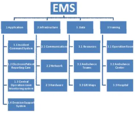
Figure 1: Project components
2.1. Infrastructure
CMIS is an integrated solution for enhancing the performance of crisis life cycle over the whole area of a country. For this reason it must contain a well established infrastructure of communication lines and networking to facilitate its major role. Infrastructure component consists of many parts as illustrated in Figure 2.
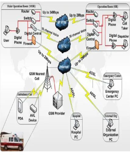
1) Communications: In this integrated solution there are several levels of communications; first level has the telephones and PCs that are connected to a digital central where ANI and ALI features have been activated. PDAs are connected to the same operation room through General packet radio service (GPRS). The second level is the communication between all rooms and the central operation room through the internet connection but is being designed to support the Virtual Private Network (VPN).
2) Hardware: The base layer consists of several types for hardware that helps the system to perform in a stability way, hardware used:
International Journal of New Innovations in Engineering and Technology (IJNIET)
Vol. 1 Issue 4 April 2013 9 ISSN: 2319-6319
Figure 2: Type of communications being implemented
• Call Receiver: in system each Call and dispatcher has own PCs that can use all features on it like ANI, AVL and Database Management System (DMS).
• Switches: each operation room consists of one switch to connect all devices existed to local network like PCs servers, router, and printers.
• Digital Central: all land lines in each operation room is connected with a special type of digital central that had been integrated with the CMIS and provide many features like ANI, ALI, Interactive Voice Response (IVR).
• Routers: each room has one router that is responsible for getting access to the internet connection and establishes the IP VPN connection.
• Plasma Screens
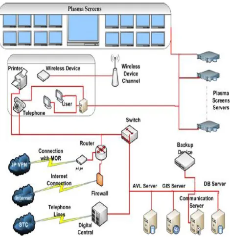
3) Network: Figure 3 shows a sample of connection types in an operation room. The operation room consists of a portion containing the receivers and some glass rooms containing the dispatchers all these are connected through cable networks with a switch that is connected to the router to access the internet. In addition, the server room which contains servers one for handling information and one works as a backup system and the other one to handle Caller Position.
2.2. Data
Vol. 1 Issue 4 April 2013 10 ISSN: 2319-6319
Figure 3: Sample of connection
2.3. Application:
The last part of this project is to implement this new technology so that the user can utilize all available features. The main features are:
1) Incident Command system: This part contains the call taker which receives the call on the application through the integration with the digital central and can identify the number whether it has been used before or already in the system through the Automatic Number Identification (ANI) also it can identify automatically the caller location thorough the Automatic Location Identification (ALI). Another item in this part is the Computer Aided Dispatch (CAD) who get all the incident information being entered by the Call Taker and have the enough information assigns the suitable ambulance unit through the Automatic Election of ambulance unit. Also he can notify the position of each ambulance vehicle through the automatic Vehicle Tracking (AVL) which is being done as a graphical real time tracking by Geographical Information System (GIS), so by this way he can know the status of each ambulance unit whether it finished the case or still in the incident place of in the crisis centre so he can choose it or choose another unit, this role also send all this information to the rescuer in the field who is using a special Mobile Computer called Portable Digital Assistant (PDA) to receive all this information and sends all medical and personal information being entered to the Operation room, with also some features like shortest path and voice guidance etc.
2) Electronic Patient Care Reporting (EPCR): This part is independent software to enhance the capacity for field personnel inside of crisis response vehicles, improving response unit communication with dispatch centres, and enabling First Responder Field Incident Reporting capabilities. The rescuer using PDA can input medical information and personal information of the patient through a graphical user interface in conjunction with some related modules used to facilitate and enhance the services being delivered to the patient as shortest path from its place to the incident place and from the incident place to the hospital with a voice guidance all this is being introduced on a GIS map, also election for the nearest hospital according to the specialization and position. Above that all step being done the rescuer has the option to confirm its timing so the person in the operation room can always know the status of this unit, and all action being done on the PDA has signature and confirming to know who is responsible for this item. PDA also is working by a technique called Occasionally Connected System (OCS) that it have its local Database also so if the GPRS connection is down right now it would not make a problem you ll be able top complete your work and save it and as soon as the connection returns the OCS system will transfer automatically the data to the operation room server.
International Journal of New Innovations in Engineering and Technology (IJNIET)
Vol. 1 Issue 4 April 2013 11 ISSN: 2319-6319 response systems, and crisis call taking systems it also allows for statistical reporting on dispatch activities. Through GIS Maps it provides real-time map displays for CAD ands, management of Automatic Vehicle Location (AVL) position data, and GIS services such as address verification and Automated Vehicle Routing, all these functionality is being monitored. Moreover these items can provide a live video streaming from all operation rooms and video streaming from special kind of ambulance containing camera to record the incident if there is a disaster or so on. All these functions give the chance for decision maker to take certain action like increasing ambulance unit in this place, or making a new branch to handle certain incident, also decision makers can propose report to external organization as police station to inform them that this area get many car accidents or so on.
III.GISSERVICESFORDISPATCHCENTERUSERS
GIS real-time services are provided to dispatch centre users by a fully custom made Viewer developed by Unicom for Communication Technology Team using the GIS regional online database, related DQL Server data tables containing data required by CAD/EPCR. The following services are provided:
• AVS: Address Verification Service (AVS) is automated utilized by loading from the Database so instead of waiting for CAD during event entry, and any time CAD requires verification of a location entered by the user. CAD sends address verification requests to AVS, specifying the location entered the system automatically perform AVS on all data entered so CAD can not at all choose a wrong or missing street name or any type of address. If a single matching location is identified, AVS returns that location to CAD. If several locations potentially match, AVS returns the list to CAD.
• AVL: Ambulance Unit forward Global Positioning System (GPS) reports from special device called Spider Net to CAD, via normal Enterprise Global System for Mobile communications (GSM) reporting is configured using distance travelled and/or elapsed time; for example, an MDC might be configured to report its position every 5 seconds and according to its status whether it is moving or no. CAD forwards just the GPS information to the AVL service, which normalizes the location report and stores it in the regional database, for use by the real-time map displays and AVRR.
• AVRR: AVRR is utilized by CAD to prepare unit recommendation displays. When a dispatcher requests a unit suggestion, CAD prepares and displays a recommendation, and also sends a list of candidate units to AVRR, along with the event location. For each candidate in the list, AVRR determines a route between the unit’s last reported GPS location and the event location, taking road closures or road vehicle restrictions into account, provides a quickest route solution, and calculates the driving time. AVRR returns the candidate list to CAD (minus any candidate for which a route could not be determined), showing the calculated drive time, and CAD adds the AVRR list to the unit suggestion display.
• Real-Time Map Displays: Real-time map displays are available at all CAD workstations. The map displays the following:
- GIS layers selected by the user; for example, street centrelines, and building. Current unit locations reported by AVL, Incident locations, for open events reported by CAD - Shortest route Information.
- Online GIS Updates: Dispatch centre users have a limited ability to apply immediate updates to the GIS database, as follows:
- Additions/changes to building/facility names and other common place identifiers, Additions/changes to street aliases and street types.
• AVL Playback: The GIS regional data manager can connect to the regional online database, and play back historical AVL data for a selected date/time range. AVL also offers an AVL “playback” service using the GIS data administration workstation where AVL position reports from Spider Net can be retrieved for a specified date/time range, and played back to review the vehicle’s route from time of dispatch to arrival at the incident location.
• GIS Services for PDA Users: GIS real-time services are provided to PDA users by GIS applications running in the PDA, using the GIS dataset loaded into the PDA; and using road closure information and dispatch notifications received from CAD. PDA do not access the GIS data GIS server located at the Operation Room Instead, each PDA associated with the installation stores one or more installation specific GIS datasets, selected in accordance with the installation(s) where the unit responds. The installation-specific GIS dataset contains complete data for the installation GIS services for PDA user’s centre on the real-time map, which shows the following:
Vol. 1 Issue 4 April 2013 12 ISSN: 2319-6319 • The unit’s last known GPS position reported to AVL and also provided to the PDA’s GIS services. • Event location for the unit’s assigned event, obtained from the last dispatch message received from CAD. • A recommended route from the unit’s current location to the event location or to any selected location. Routes are calculated within the PDA by its GIS services.
• Road closure information.
IV. PERFORMANCE MEASUREMENT
After completing this large project there must be a way to measure its performance in a scientific way. For this aim we can create Key Performance Indicators (KPIs) for all project stages.
Types of KPIs are:
• KPIs for Delivering Hardware and software • KPIs for Installing Hardware and software • KPIs for operating the system
V. CONCLUSIONS
Implementation of CMIS provides an integrated, scalable, and expandable Crisis Management Information system to support First Responders at field. CMIS provides positive operational and organizational impact by improving crisis response management through the utilization of automated, reliable products and procedures. As a conclusion, the change management operation will be the most critical model in future, success factor in this kind of huge projects.
REFERENCES
[1] Turoff, M., Chumer, M., Van de Walle, B., Yao, X. (2006). “The Design of a Dynamic Crisis Response Management Information System” (DERMIS), Annual Review of Communications 58 (March) 637-661
[2] Mendonça, D., G. E. G. Beroggi and W. A. Wallace (2001). “Decision Support for Improvisation During Crisis Response Operations.” International Journal of Crisis Management 1 (1) 30-38
[3] D. Minoli and E. Minoli, Web Commerce Technology Handbook, New York, McGraw-Hill, 1998.
[4] J. Pinker, A. Seidmann and R.C. Foster, “Strategies for Transitioning Old Economy Firms to E-Business”, Communications of the ACM, May 2002, Vol. 45, no. 5, p. 77-83.
[5] P. Ratnasingham “Trust in Web-Based Electronic Commerce Security”, Information Management and Computer Security, 1998 Vol. 6, no. 4, p 162-166