VOLUME 16 ISSUE 2 (2018), Page 153 - 163
HISTORICAL URBAN FORM: A CASE STUDY OF MELAKA
Illyani Ibrahim1, Alias Abdullah2, Mansor Ibrahim3, & Fatin Farhana Murtaza4
1,2,3,4Kulliyyah of Architrcture and Environmental Design,
INTERNATIONAL ISLAMIC UNIVERSITY MALAYSIA
Abstract
Understanding the urban form is crucial in determining the structure of a city in terms of physical and nonphysical aspects. The physical aspects include built-up areas that can be seen on the earth surface, and the nonphysical aspects include the shape, size, density, and configuration of settlements. The objectives of this study are to (i) analyse the elements of historical urban form that are suitable for the site and (ii) to study on the elements of urban form in Melaka. Content analysis was adopted to analyse the literature of urban form and Melaka. Results show that the following four elements of urban form are suitable to be used for historical urban form analysis: (i) streets, (ii) land use, (iii) buildings, and (iv) open space. The findings also indicate that the selected urban form has successfully delineated in the historical of Melaka as the selected urban elements can be specifically scrutinized with the content analysis. Further study will focus on the historical urban form within the Malay Peninsula.
.
INTRODUCTION
In certain historical period, historical urban areas took the form of various landscapes. UNESCO defines a historic urban landscape as “an urban area understood as a result of a historic layering of cultural and natural values and attributes, extending beyond the notion of historic centre or ensemble to include the broader urban context and setting.” Urban form is defined as the physical characteristic on the earth surface with a combination of built-up areas that can extend various scales, namely block, street, neighbourhood, urban, and regional. Urban form has also been defined as a “settlement form as a spatial arrangement of physical environment, the resulting spatial flows of persons, goods and information, and the physical features which modify spaces” (Lynch, 1984). This definition implies that an urban form does not merely constitute the physical aspects of a city but also the changes of its forms.
Spaces and objects that are related to a historic built environment (HBE) play a significant role in providing many of the attributes necessary for pleasing an urban form (Lynch, 1960). Space refers to build and unbuilt elements that exist on the ground surface, and urban form is the collective ensemble of these spaces (Newman, 2016). Space typologies are multiple and can include plazas, squares, streets, avenues, alleys, structures and many others.
However, after more than hundreds of years, many elements of HBE are removed or destroyed hence the urban forms proved difficult to preserve. An urban form evolves constantly in response to several factors, such as social, environmental, economic, and technological developments; planning, housing and urban policies; and health, transport, and economic policies. Nevertheless, these typologies are the micro elements that need to be defined.
While the past is mostly unreachable, every detail of its life (and all other events) remains recorded in the matrix of space and time, and all are capable of some kind of review (Brush, Fabos, & Zube 1975). Past events are not always tangible, but they are important nonetheless. Therefore, reviewing the literature of historical books and hikayat, to list a few, is important in order to understand past events that may be related to historical urban form.
Table 1: Literature on the elements of urban form
Author Elements
Relph (2014) & Kostov (2004)
Plan of streets and property boundaries, land use, the urban fabric of buildings and materials
Lynch (1984) Path, edges, districts, nodes and landmarks
Scargil (1979) Buildings and skylines
Krier (1979) Squares (buildings) and streets
Valente-Pereira (1982) Landscape/soil, outdoor spaces, buildings
Heryanto (2001) Building form, street pattern, land use, open space, skyline.
Anderson et al. (1996) Type of urban settlement (market town, central
business district or suburbs)
Williams et al. (2000) Building materials, facades and fenestration, housing
type, street type and their spatial arrangement / layout Dempsey et al. (2008) Size, shapes, scale, density, landuses, building types,
urban block layout, distribution of green spaces
This paper is organized as follows. Section 2 provides related examples of a historical of urban form. In section 3, method is discussed. In further, section 4 is discussing on the analysis of urban form. Section 5 on the empirical case study of Melaka is presented. The analysis and findings in this paper are presented in section 6 and the final section concludes the discovery.
HISTORICAL URBAN FORM
The section will focus on the cities built between 1200 CE and 1900 CE. This timeline was selected as the timeline of the case study is in Melaka was also between the same timeline.
Many of the cities in China are located at the low land; in floodplain, river valleys, intermountain basins, and small oases along the foothills (Chang, n.d.). Those city walls were built to protect palaces, temples, residences and administrative area. The road leading from the bridge to the gate was seldom straight. Many traditional areas are also devoted as a cultivation and water bodies as a recreational areas.
In Lahore, India, a walled city of Lahore, the old historic core is built on elevated ground with a mosque as focal point, surrounded by Bazaars, Badshahi Mosque Greater, while the spatial distribution of bazaar is following a linear clusters along the primary streets, and the residential area was built on privacy principles, courtyards oriented with a 2-3 stories (Gulzar, 2017).
The historical view of Toronto (Relph, 2014) begins in the centre and the fields became more numerous than houses. Built in 1792, Toronto’s streets and lot patterns were simply laid out as smaller rectangles within the master grid of concession roads.
In 1869 in the residential suburbs in Illinois, the streets were curvely planted and the houses were set back from the streets. A park was located along the river and pocket parks were seen at the road junctions.
in the field, the paved high road, and the fortified villa-farm on the hill (Kostov, 2004).
In the case Novgorod, Russia, the same author (Kostov, 2004) mentions that in 1635, on the side of the Volkhow River was a brick-walled kremlin and a fortress that located the cathedral and administrative headquarters. Opposite the river was a wooden-walled market crammed with merchants’ homes, warehouses, and churches founded by individuals or local communities. Many towns built at the river bank have given a character to a city form. The settlements in some of the cities were arranged following the river; some of the settlements were mixed developments with shops at the lower floor and residential facilities at the upper floor.
In 1873, the old dense city of Vienna was located at the city centre with a monument. Several elements in the city provided a protective zone between classes, namely the suburb areas, major civic and national administrative buildings, cultural institutions, and a few elegant residential blocks that were interspersed with public gardens (Kostov, 2004).
However, Mecca in 1884 was a town with traditional low-rise structures and a courtyard-housing Islamic city. The city located many three-storey houses with windows overlooking the streets. Another evidence by al-Muqaddasi (by referring to Burckhardt (1829) in (Morris, 1994) mentions that the houses of Mecca were built in black, smooth, and white stones with a brick at the upper part of it. Narrow streets also served to cool the air. A musolla became an open space for public for both mosques in Mecca and Medina. In addition, the streets were the public space, and a pocket space and courtyard can be found in residential houses.
The mosque of Medina was situated at the eastern side of the town, and it was built entirely of stone. The houses were generally two-storeys with flat roofs. A few of the principal streets were paved with large blocks of stone and the markets were located at the left and right side of the streets. The gardens, dates and wheat plantations, as well as barley fields surrounding the suburbs are explained by Burckhardt (Morris, 1994).
METHODOLOGY
ANALYSIS ON THE USE OF URBAN FORM
The uses of the urban form were analysed by examining relevant theories of urban form as employed in previous studies (Table 2). This analysis will answer the first objective, which is to analyse the elements of historical urban form that are suitable for the site.
Table 2: The use of urban form and the authors
Elements of Urban Form Authors
Streets/path Relph (2014); Lynch (1984); Krier (1979); Heryanto
(2001); Williams et al. (2000)
Edge Lynch (1984)
Districts Lynch (1984)
Nodes Lynch (1984)
Buildings/landmarks Relph (2014); Lynch (1984); Scargill (1979); Krier
(1979); Valente-Prier (1982); Heryanto (2001); Williams et al. (2000)
Materials Relph (2014);
Open space Valente-Pereira (1982); Heryanto (2001); Williams et al.
(2000)
Skylines Scargill (1979); Heryanto (2001)
Landscape/soil Valente-Pereira (1982)
Walls Morris (1994)
Market Morris (1994)
Churches Morris (1994)
Landuse Lynch (1984); Heryanto (2001); Morris (1994);
Anderson et al. (1996); Williams et al. (2000) Size, shapes, scale, density Williams et al. (2000)
as it is a low resolution, as currently those physical elements are not there and difficult to measure using the good resolution. The good level of resolution will show a better details.
The analysis was arranged according the events’ during the reign of Sultan Mahmud Shah. As no direct analysis on the urban form was written in the books, thus the extraction of the urban form from the literature review was appropriate for this study. Thus, based on the discussion of the physical structure of the urban form, four major elements that have shaped the urban form are building, street pattern, land use pattern, and open space. Therefore, the analysis of urban form for Melaka historical city will be tested and guided based on these elements. Further section will answer the second objective that is to study on the elements of urban form for Melaka area.
ANALYSIS DURING THE REIGN OF MELAKA SULTANATE
Melaka was founded by Parameswara who fled Palembang and Temasek in 1400. He embraced Islam since 1414 and had his name changed to Megat Iskandar Shah. He managed to change Melaka to a bustling entrepot in Asia and spreaded Islam in this region. Merchants from Arabia, Persia, India, China, the Malay Archipelago, and even such distants corners of the world such as Portugal and Japan could be found in the marketplace of Malay Melaka (Lewis, 1995). However, Melaka was captured by Portuguese in 1511 for 130 years, then by Dutch in 1641, and in the year of 1826, was took over by British.
The historical Melaka city was located near the river. It was still preserving the nature of sloping and hilly areas as a place for agriculture. This characteristics indicate that the old city conformed to the natural landscape despite the development of early technologies. This old city were located next to the river because it was easy to obtain water supply and because transportation from out of the cities were mostly from oceans across to the river. The rivers served not only as an instrumental and economic value for transporting goods and people, but also a key component of the urban landscape.
This city served as centers of administration and defence. The palace of Parameswara was located on the hilltop on the Melaka Hill (previously St. Paul’s hill) and close to the port. Zheng He also mentions about the structure of the sharp wood surrounding to the palace (fort) which functioned as fences. There was also a grand entrance where a tower was placed (Kong, 2000).
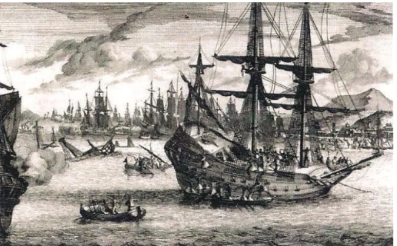
Figure 1: Melaka view from the Portuguese in 1509 before the attack
Source: Van Der Aa (1706)
Figure 2 (below) shows a sketch of Melaka port view from the sea on the Portuguese ship. A buildings of two and three floors, a dome and minarets of the mosque were seen. The mosque and palace are made by stone as a strong materials and there also a smaller buildings also made by stone located nearby the mosque (Correia, 1858). These sketches represents.
Figure 2: A close-up view of Melaka
Source: Van Der Aa (1706)
The settlements were found to be concentrated on the riverside and in front of the sea. There are many beautiful stone and wooden houses. Those settlements in the agriculture areas were found to be dispersed. During Zheng He’s visit in 1414, he added that the houses were like rooftop houses about four yards high, on which there was no board. There was roof sago palm leaf tied with rattan rope. Many shops for the trade activities operated on the bridge crossing the river.
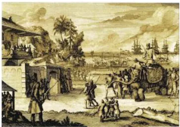
Figure 3 shows a part of Melaka Fort sketched by Portuguese in 1509 during the visit of Lopez De Sequeiraa as a representative of Portuguese. The sketch was directed to the sea and a structure like a brick wall, gates and part of the building inside the wall was seen. Elephants used as a transportation modes on the land and ships or boats used on the sea or river.
Figure 3: A part of Melaka fort in 1509
Source: Van Der Aa (1706)
It was further elaborated that a market was located at the beach at the mouth of the river (de Eredia, 1930). During Sultan Mahmud’s reign, Melaka secured tax revenue from street sellers(Pires, 1944). Merchants from Jawa had been selling a variety of rice and edible grain in the market, and monancabos from Sumatera had been sending stocks by boats to market in Melaka. The stocks were transferred with sampans or cargo boats. Shops are also located in front of the houses (Pires, 1944).
Farming was another routine of the dwellers in Melaka. The law of Melaka or Undang-undang Melaka dictates that farms need to be well maintained and fenced by the owner. The natives dwelled in their orchards and gardens along the banks of Melaka River. They had been raising large herds of cattle and animals such as geese, ducks, and fowls (de Eredia, 1930). An account (Pinto, 2011) notes that up to 8 to 10 miles (12 to 16 km) in the suburbs area were mostly covered with large orchards, beautiful meadows, or pastures for livestock and rice fields under cultivation. These statements indicate that agriculture activities also took place in the suburban areas.
Table 3 show the analysis elements of urban form based on the event analysis. The analysis of Melaka events show that the construction of fort was essential as an administration and defence centre. The palace was important for the residential of Sultanate; it existed before the attack of Portuguese. The market was located nearby the beach so the stocks from other areas can be easily transferred. In terms of land use, there were farms, orchard, and gardens which acted as agricultural areas, and the transportation areas were linear street pattern with a mixed use of residential and commercial areas.
Table 3: Urban form elements and the characteristic of Melaka City during the Melaka Sultanate
Urban Form Characteristics of the Area
Streets Linear streets, playing a role to differentiate land cover
Streets divided into two modes; road and river Melaka river as an important transportation
Land Use Clustered settlements in the coastal area and dispersed in the
agricultural area
Gardens, orchards, and farms among the land use types Market on the bridge, along the streets and nearby the beach
Buildings Walled palace
Port near the river opposite to administration area Fort surrounding palace
Mosque close to the palace
Open space Orchard and graveyards close to the river
In terms of land cover, most of the areas were distributed according to their land use. Only seven land cover areas can be identified: administrative area, mosque, shops, settlement, rivers and streets, agricultural area, and graveyards. Rivers and streets were the main important features that served as transportations areas.
still an important transportation in Venice and Dutch cities, whose canal streets played a distinctive and gracious role (Kostov, 2004). In Melaka, the palace was walled with an imported grave tomb, indicating a high rank and power of those living in it (Lynch & Rodwin, 1958). In addition, the city of Melaka was located on the hilltop and close to the river, a view that contradicts that of Alattas (1997) who claims that the Southeast Asian riverine city was located on hilltops.
CONCLUSION
This research confirms that the use of the four urban form elements are appropriate for analysing historical urban form. Future studies might consider using these urban form elements to analyse the historical urban form for the whole Malay Peninsula.
ACKNOWLEDGEMENT
This work was supported in part of Transdisciplinary Research Grant Scheme (TRGS) No. TRGS/1/2016/UIAM/01/5/1.
REFERENCES
Alatas, S. M. (1997). Cultural symbolism and legitimization in the context of change :
Early Malay state formation. Colombia University.
Anderson, W. P., Kanargoglou, P. S., & Miller, E. (1996). Urban form, energy and the environment. Urban Studies, 33, 17-35.
Brush, R. O., Fabos, J. G., & Zube, E. H. (1975). Landscape assessment: Values, perceptions, and resources. Stroudsburg, PA: Dowden, Hutchinson & Ross. Chang, S. (n.d.). The morphology of walled capitals. S.l.: S.n.
Correia, G. (1858). Lendas da India. Lisboa: Typ. da Academia real das sciencias. de Barros, J. (n.d.). On the deeds & discoveries & conquests made by Portuguese in the
seas and Eastern Lands. Divisao de Publicacao e Biblioteca Agencia Geral das Colonias Lisboa.
de Eredia, E. G. (1930). Eredia’s Description of Malacca. KMBRAS.
Dempsey, N., Brown, C., Raman, S., Porta, S., Jenks, M., Jones, C.,… & Urban, E. (2008). Sustainable city form (Vol. 2).
Gulzar, S. (2017). Walled city of Lahore: An analytical study of Islamic cities of Indian subcontinent. International Journal of Research in Chemical, Metallurgical and Civil Engineering, 4(1), 69-73.
Heryanto, B. (2001). The spirit and image of the city: A case study of the changing and developing urban form of Ujung Pandang, Indonesia (Doctoral dissertation). Virginia Commonwealth University, 2001.
Kostov, S. (2004). The city assembled: The elements of urban form through history. New York: Thames & Hudson.
Krier, R. (1979). Urban space (Stadtxaum). New York: Rizzoli.
Lewis, D. (1995). Jan Compagnie in the Straits of Malacca 1641 - 1795. Monographs in
International Studies Southeast Asia Series, No 96.
Lynch, K. (1984). A theory of good city form. Cambridge, MA: MIT Press. Lynch, K. (1960). The image of the city. Cambridge, MA: MIT Press
Lynch, K. & Rodwin, L. (1958). A theory of urban form. Journal of the American Institute of Planners, 24(4), 201-214.
Morris, A. E. (1994). History of urban form before the industrial revolutions. Harlow: Longman.
Newman, G. D. (2016). The eidos of urban form: A framework for heritage-based place making. Journal of Urbanism: International Research on Placemaking and Urban Sustainability, 9(4), 388-407.
Noor, S. Z. S. M. (2013). Pentadbiran Kesultanan Melayu Melaka: Kemunculan dan kegemilangan. Kuala Lumpur: Arkib Negara Malaysia.
Pinto, P. J. S. (2011). Os casados de Malaca, 1511-1641: estratégias de adaptação e de sobrevivência.
Pires, T. (1944). The suma oriental of Tomé Pires: An account of the east, from the Red Sea to Japan, written in Malacca and India in 1512-1515, and the Book of Francisco Rodrigues, rutter of a voyage in the Red Sea, nautical rules, almanac and maps, written and drawn in the East before 1515 (Vol. 1). London: Hakluyt Society.
Relph, E. (2014). The urban form of Toronto.
Scargill, D. I. (1979). The form of cities. London: Bell & Hyman. Tun Sri Lanang (n.d.) Malay Annals.
Valente-Pereira, L. (1982). Definição da Forma Urbana no Planeamento Físico Urbanistico.
Van der Aa, P. (1659). Leiden 1659 - 1733.
Williams, K., Burton, E., & Jenks, M. (2000). Achieving sustainable urban form. London: E & FN Spon.
Yusof, H. (2017). Teknologi kesultanan Melaka: Membongkar keagungannya