Procedia Environmental Sciences 10 ( 2011 ) 576 – 582
doi: 10.1016/j.proenv.2011.09.093
2011 3rd International Conference on Environmental Science and Information
Application Technology
Local Path Searching Based Map Matching Algorithm for
Floating Car Data
Feng Chen
a,*, Mingyu Shen
b, Yongning Tang
caDepartment of Automation, University of Science and Technology of China, Hefei, 230027, China bSchool of Computer and Information Science, Hefei University of Technology, Hefei, 230066, China
cSchool of Information Technology, Illinois State University, Normal IL 61790, USA
Abstract
The information acquisition of road traffic flow is requisite for urban traffic control and management. Floating car data (FCD) is emerging technique for traffic flow collection of urban large-scale road network, and it can provide effective means to model and analyze road traffic conditions. Map-matching is one of the key techniques for FCD. The typical navigation map-matching algorithms are not suitable for handling FCD with large sample interval. Through analyzing FCD characteristics, we first propose FCD map-matching algorithm based on local path searching. The information of the previous matched GPS point is utilized to reduce the search space significantly. Square confidence area is constructed to decrease the number of candidate paths. This algorithm can not only achieve FCD location with high accuracy, but also determine vehicle moving trajectory. The experimental results show our method is robust for the different sample intervals of FCD.
keywords:Floating car data; Local path searching; Map-matching, Sample interval; Square confidence area
1.Introduction
The information acquisition of road traffic flow is requisite for urban traffic control, management, and transportation planning. The existing collection methods of road traffic flow mainly adopt the fixed-point
* Corresponding author. Tel.: 86-551-3600917; fax: +86-551-3603244
E-mail address: [email protected].
2011 3rd International Conference on Environmental
Science and Information Application Technology (ESIAT 2011)
© 2011 Published by Elsevier Ltd.
Selection and/or peer-review under responsibility of Conference ESIAT2011 Organization Committee.Open access under CC BY-NC-ND license.
1878-0296 © 2011 Published by Elsevier Ltd.
Selection and/or peer-review under responsibility of Conference ESIAT2011 Organization Committee. Open access under CC BY-NC-ND license.
modes including induction loop, microwave, radar and video techniques, which have some drawbacks such as limited coverage region, high costs, and difficulty to maintenance.
In comparison to the fixed-point collection modes, FCD has advantages of large coverage region, ease of maintenance, and low costs. It can offer large-scale dynamic traffic information, and is thus effective
means for traffic real-time guidance, management and control. FCD has received significant attention in the past decades [1, 2]. Map-matching algorithms have become a topic of FCD research. So far, FCD map-matching mainly relies on navigator map-matching algorithms. In general, navigator map-matching algorithms in the literatures can be classified into four groups: geometric analysis, topological, probabilistic, and other advanced methods [3].
The commonly utilized geometric analysis methods include “point-to-point” [4], “point-to-curve” [5], and “curve-to-curve” [6] map matching algorithms. Considering the shape of road, these methods exploit the geometric information of spatial road network data for map matching, and have simple and fast performances. As the relations of connectivity and contiguity are not taken into account, these methods have worse identification results in the conditions of intersection, parallel lines, and roundabout [7]. A map matching algorithm, which makes use of geometric feature, connectivity and adjacent relations among road segments, is called a topological map matching algorithm [8]. As vehicle heading and speed are not taken into account, topological methods are sensitive to outliers. Probabilistic map matching methods construct elliptical or rectangular error region around position fix. The error region can be determined by the related error variance of GPS positioning. The road segments within the error region are candidate solutions. These algorithms use heading, connectivity and close metric for map matching [9]. Advanced map matching algorithms utilize Kalman filter, evidence theory, fuzzy logic and neural network for map matching. These methods are superior to the other three kinds of methods in the same conditions, but they need more input data, and have some drawbacks such as slower matching speed and difficulty to implement [10].
Navigation map matching algorithms can obtain good results for the GPS data with high sample frequency (e.g. 1 Hz). However, the sample interval of FCD is from 10 seconds to 2 minutes, and it may be time-varying due to noise inference and error. Therefore, it is difficult for navigation map matching algorithms to deal with FCD. So far, little work has done for FCD map matching. Liao et al. proposed a bidirectional heuristic map matching algorithm for intersections based on a data structure for intersections [11]. This algorithm apply the data structure of intersections to separates the intersection part from common map matching, and decreases the FCD map matching mistakes. However, its computational complexity is significantly increased due to adding too many the shape nodes and links for intersection. Based on grid division of GIS digital map, Wang et al. proposed a quick map matching algorithm for FCD [12]. This approach designs a structure of road network which divides the road network into two levels, and partitions the road network into mesh. However, it is high difficult to determine the size of grid.
The objective of this work is to study map matching algorithm for floating car data with large and dynamic sample interval. According to the characteristic analysis for FCD, we first proposed FCD map matching algorithm based on local path searching. Maximal possible distance is adopted as heuristic information to reduce search space. Square confidence region centered position fix from GPS is constructed to determine candidate matching paths effectively, and then vehicle heading and the distances between position fix to links are integrated to match FCD to correct road segment.
The rest of this paper is organized as follows: section 2 introduces FCD map matching, the principle of heuristic local path searching and the construction method of square confidence region are presented. Section 3 givens the description of FCD map matching algorithm. In section 4, the results of experimental testing are given and discussed. A final section concludes the entire work.
2.The Principle of FCD Map Matching
Map-matching is one of key techniques for FCD. Each FCD record consists of vehicle ID, longitude & latitude, time, vehicle heading, and instantaneous velocity. FCD technique is mainly applied to provide traffic managers and users with the traffic conditions of road networks. The common sample frequency of FCD is from 10 to 120 seconds by considering communication costs. The environmental interferences can cause the time interval between two FCD more than 30 seconds in remote monitoring center. In allusion to dynamic sample interval of FCD, we propose a map-matching algorithm based on local path searching. This proposed method can identify travel path between two adjacent GPS positions for a vehicle, which is requisite for traffic guidance, control, and traffic condition estimation based on FCD technique.
This proposed algorithm mainly including three steps: local path searching, square confidence region generation, and map matching. For the issues of position fix for the first GPS point in FCD packets, considering the related information unavailable, we locate this GPS point using “point-curve” method with high accuracy.
2.1.local path searching
GIS (GIS: geographic information system) digital map is a directed connected graph. This proposed map matching algorithm firstly searches all candidate paths in which current position fix is destination node and its previous matched position is original node. Due to huge urban road network, the maximal possible distance is introduced as heuristic information to decrease the computational complexity of this traversal search algorithm. It is defined in the following.
t
v
d
max max'
˄1˅Where vmax is permissible maximum speed of vehicle in urban road,
'
t
is time interval between twoadjacent GPS points of a vehicle. The terminal condition of path searching is:
G
d
d
maxd
˄2˅Where
d
is path length, andG
is GPS error caused by environmental interferences. Search space can be significantly reduced by introducing maximal possible distance. After traversing the road network, all acyclic paths which satisfy Equation 2 are candidate solutions.2.2.square confidence region construction
After the local path searching process, there may be too many candidate matching paths. Therefore, square confidence region is defined to further reduce the number of candidate paths. Square confidence region is constructed according to the center point Pi and the distance dmax(shown as Fig.1). The detailed
description is as follows.
Assuming Pi is current position fix from GPS and Pi-1 is its previous matched location. The coordinate
of position fix Pi is (x, y), and the coordinate of Pi is (x1,y1)ˈwhere
x
andx
1 are latitude,y
andy
1 islongitude.
The vertexes coordination of square confidence region can be calculated according to the distance from Pi to each edge dmax and the center point Pi. The difference of latitude can be obtained in term of
Equation 3.
ree
d
lat max
/
deg
The previous matched point
Point fix from GPS
where
360
1609
24901
deg
ree
u
.The difference of longitude is calculated by Equation 4 and 5.
)
180
/
cos(
deg
ree
u
x
u
S
k
(4) lon=dmax/k (5)Figure1. Square confidence region
As a result, the vertex coordinates of square confidence region can be obtained as follows:
)
,
(
x
'
laty
,(
x
'
lat,
y
)
,(
x
,
y
'
lon)
, and(
x
,
y
'
lon)
.Square confidence region can be used to further select candidate matching paths. A candidate path is valid if its end road segment is within square confidence region. The next step is to determine the matching path. The candidate paths are selected by the information of vehicle heading provided by the corresponding FCD record. If the difference of vehicle heading and the end road segment heading of a candidate path satisfies certain error range (e.g. 15o ), this path is reserved, otherwise, it is removed from candidate path set. Finally, the distance between the fix point from GPS and the end road segment in candidate path is calculated for all the residual candidate matching paths. The candidate path with shortest distance is matched. The fix point from GPS is located by projecting it on the end road segment of matched path.
3.The Description of FCD Map Matching
Suppose
G
is threshold of GPS error,V
is threshold for difference between two direction angles, andvmax is maximal possible speed for a vehicle. FCD map matching algorithm is described as follows.
Initialize the parameters
G
,V
and vmax;If current position fix from GPS is the first FCD then “point-to-curve” method is used for matching process
else { Repeat
sĕthe previous matched GPS point,
GPS data from FCD of the same vehicle is taken and assigned to s’, Calculating
d
maxv
max'
t
,Traversing road network by starting from s, a acyclic path, which satisfies the condition of
G
d
d
maxd
path , is candidate matching path and stored inA
candidate //d
path is path length,Square confidence region is constructed by the vertexes coordinates:
)
,
(
x
'
laty
(
x
'
lat,
y
)
,(
x
,
y
'
lon)
, and(
x
,
y
'
lon)
,A path is removed from set Acandidate if its end road segment is outside square confidence region,
Calculating difference c of vehicle heading from FCD record and the end road segment of candidate path,
If
c
d
V
then the corresponding candidate path is reserved, else it is removed from set Acandidate,For all the candidate paths in set Acandidate, calculating the distance between GPS point and the end
road segment,
The path with shortest distance is selected,
Projecting point s’ on the end road segment of this path} Until all the FCD records are handled.
4.The Experiment and Discussion
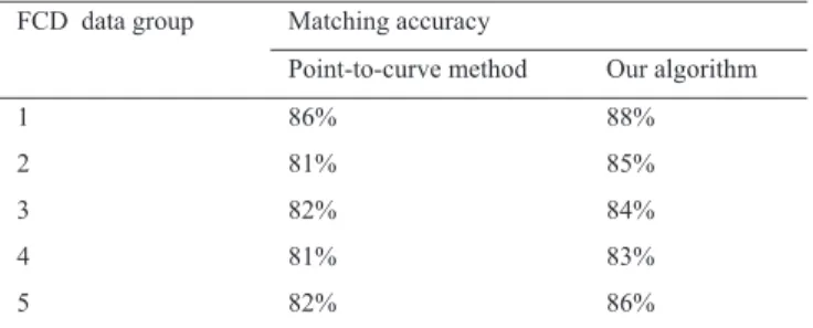
To evaluate this proposed algorithm, we employed probe vehicle to collect field data of road network in Hefei city, China. 20,000 FCD records were obtained to build a standard sample base, which is used to validate our algorithm. At first, the experiments were conducted respectively using our algorithm and “point-curve” method with high accuracy. In the experiment, the sample interval of FCD is 10 seconds, five groups of FCD packets were used and each group has 400 FCD records. The experimental results are listed in table 1. From table 1, we can see that the matching accuracy of our algorithm is 85.2%, accordingly, the matching accuracy of “point-curve” method is 82.4%.
Table 1. Comparison of the proposed algorithm and “point-curve” map-matching algorithm
FCD data group Matching accuracy
Point-to-curve method Our algorithm
1 86% 88% 2 81% 85% 3 82% 84% 4 81% 83% 5 82% 86%
Table 2. The experimental results of the proposed algorithm for FCD with different sample intervals
Further, we adopted the FCD records respectively with 50 and 100 seconds to test the influence of the sample interval on this proposed algorithm. In this experiment, three groups of FCD packets were
FCD data group Matching accuracy
Sample interval:50s Sample interval:100s 1 87% 88% 2 88% 87% 3 85% 86%
selected. Each group had 200 FCD records. The experimental results are shown in table 2. It is easy to see that the matching accuracy of our algorithm is insensitive for sample interval of FCD.
5.Conclusion
FCD map matching is one of key techniques for urban traffic dynamic route guidance. Navigator map matching methods are not suitable for handling FCD record with large sample interval. By analyzing the characteristics of FCD records, we propose FCD map matching algorithm based on local path searching. The time series information of FCD is utilized to reduce the search space significantly. Further, square confidence region is introduced to decrease candidate matching paths. This proposed algorithm has high matching accuracy and is robust for sample interval of FCD. It can accomplish FCD map matching and the identification of vehicle trajectory simultaneously. This work offers an effective way for FCD map matching.
Acknowledgements
This work is funded by the National Natural Science Foundation of China (Grant No.: 60974092), which is grateful.
References
[1] Stefano Messelodi, Carla M. Modena, Michele Zanin, et al., Intelligent extended floating car data collection, Expert Systems with Applications, 2009, 36(3): 4213-4227.
[2] Feng Chen, Hao Pang, Xinxin Sun, et al., FCD parallel computing and dynamic guidance for urban traffic on KD-50-I-E platform, Journal of University of Science and Technology of China, 2009, 39(5): 558-560.
[3] Mohammed A. Quddus, Washington Y. Ochieng, Robert B. Noland, Current map-matching algorithms for transport applications: State-of-the art and future research directions, Transportation Research Part C: Emerging Technologies, 2007, 15(5): 312-328.
[4] Greenfeld, J. S., Matching GPS observations to locations on a digital map, Proceedings of the 81st Annual Meeting of the Transportation Research Board, January, 2002, Washington D.C.
[5] White, C.E., Bernstein, D., Kornhauser, A.L., Some map-matching algorithms for personal navigation assistants,
Transportation Research Part C, 2000, 8: 91-108.
[6] Bernstein, D., Kornhauser, A., An introduction to map-matching for personal navigation assistants, http: //www. njtude.org/ reports/mapmatchintro.pdf, 2002.
[7] Nagendra R. Velaga, Mohammed A. Quddus, Abigail L. Bristow, Developing an enhanced weight-based topological map-matching algorithm for intelligent transport systems, Transportation Research Part C: Emerging Technologies, 2009, 17(6): 672-683.
[8] Li, Z., Chen, W., A new approach to map-matching and parameter correcting for vehicle navigation system in the area of shadow of GPS signal, Proceedings of IEEE Conference on Intelligent Transportation Systems, 2005: 425- 430.
[9] Ochieng, W.Y., Quddus, M.A., Noland, R.B., Map-matching in complex urban road networks, Brazilian Journal of Cartography, 2004, 55(2): 1-18.
[10] Quddus, M.A., Noland, R.B., Ochieng, W.Y., A high accuracy fuzzy logic-based map-matching algorithm for road transport, Journal of Intelligent Transportation Systems: Technology, Planning, and Operations, 2006, 10 (3): 103̢115.
[11] Wenjie Liao, Weifeng Lv, Tongyu Zhu, Dong Dong Wu, A map matching algorithm for intersections based on Floating Car Data, 10th International Conference on Advanced Communication Technology , 2008,1: 311- 316.
[12] Wang Zuyun, Du Yong, Wang Gang, Wu Dongdong, A Quick Map-Matching Algorithm by Using Grid-Based Selecting, International Workshop on Geoscience and Remote Sensing, 2008, 1: 306-311.