Prepared by
District 3A ITS Scoping Study
MEMORANDUM VI
Implementation Plan
TABLE OF CONTENTS
VI.
IMPLEMENTATION PLAN... VI-1
A. Overview ...VI-1 B. Conceptual Design Approach...VI-1 1. Deployment Schedule and Phasing...VI-1 2. System Component Descriptions ...VI-4 3. TOCC Migration Plan...VI-11 4. Software ...VI-11 5. Systems Integration...VI-11 6. Cost Estimates...VI-11 C. Integration/Scalable Opportunities ...VI-13 D. Funding Alternatives ...VI-13 1. Government-Funded Programs ...VI-14 2. Public-Private Partnerships...VI-15 E. Operations and Management Plan...VI-15 1. Operations ...VI-16 2. Maintenance...VI-16 3. Personnel Resources ...VI-17 4. Training...VI-18LIST OF FIGURES
Figure VI-1 – Short and Intermediate Term Implementation Plan – Field Elements VI-3
LIST OF TABLES
Table VI-1 – Deployment Schedule VI-2
VI.
IMPLEMENTATION PLAN
A.
OverviewPrevious project memoranda have identified and documented the following: outreach, inventory and research activities, existing or baseline transportation related conditions, user problems and needs, and recommended Intelligent Transportation System (ITS) technologies. This document provides an implementation strategy and sequence of deployments at a conceptual level to implement the ITS elements of the District. This document identifies a program of coordinated activities by defining what, where, and when these activities will happen. In addition, this document considers the phasing, staffing, and funding options available for deploying the ITS.
B.
Conceptual Design ApproachThe conceptual design of the ITS for District 3A has been developed in a series of steps documented in previous memoranda. The insight and information obtained through these steps from partner agencies was critical in the development of the ITS conceptual design for the District. Based upon the partner agency requirements and expectations, many ITS technologies were identified and assessed. As a result, the most applicable ITS technologies and elements for implementation in the District 3A transportation corridor were identified.
1.
Deployment Schedule and PhasingTable VI-1 lists the identified recommended ITS technologies for District 3A. The technologies are grouped by anticipated deployment phase. Short-term projects represent initiatives that are recommended for deployment within the next two years. Intermediate projects should be considered for implementation between three and five years from the date of this memorandum. Deployment of projects that have been identified as long-term should be considered beyond six years from the publication date. However, the phasing of recommended technologies will need to be reevaluated as funding becomes available and as the needs of stakeholders and partner agencies develop over the coming years.
Table VI-1 Deployment Schedule
Short Term (0 – 2 years)
• Emergency Vehicle Preemption
• Closed Loop Signal Control
• Closed Circuit Television (CCTV) Surveillance
• Road Weather Information Systems (RWIS)
• Inductive Loop and Non-Invasive Detection
• Weather Information Dissemination Systems
• Dynamic Message Signs (DMS)
• Interagency Signal System Coordination
• Automatic Anti-Icing System
• Route Diversion System
• Paratransit Reservations/Scheduling/Dispatch Software
• Computer Aided Dispatch (CAD)
• Control Center
Intermediate Term (3 – 5 years)
• Inductive Loop and Non-Invasive Detection
• Automatic Anti-Icing System
• Seasonal Service Patrols
• Closed Circuit Television (CCTV) Surveillance
• Dynamic Message Signs (DMS)
• Road Weather Information Systems (RWIS)
• Automatic Vehicle Location (AVL)
• Highway-Rail Alert/Crossing Systems
• Automated Visibility Warning Systems
• Paratransit Reservations/Scheduling/Dispatch Software
• TOCC Access for County/City Agencies
Long Term (6 – 10 years)
• Closed Circuit Television (CCTV) Surveillance
• Dynamic Message Signs (DMS)
• Seasonal Service Patrols
• Transit AVL/MDT Systems
• Public Vehicle Fleet Management Systems
• Smart Plows/Agency Vehicle Monitoring
• Integrated Land/Mobile Radio
• Integrated Weather Monitoring/Prediction Systems
• Integrated Communications Systems
• Paratransit Reservations/Scheduling/Dispatch Software
Ongoing
• Public Agency Outreach for Transportation Management
• Television/Radio
• Information on the Internet
• 511/Traffic Information Telephone Number
• Mayday Systems
• Geographic Information Systems (GIS)
2.
System Component DescriptionsEach of the functions of an ITS requires one or more elements or components. A number of these components require hardware that must be physically in place; others are procedures and strategies that are enacted by agency personnel. Generally, these components can be categorized as existing either in the field, as part of a communication linkage, or within a control center. Therefore, the ITS components of District 3A have been broken down into three categories: field elements, TOCC integration/control center, and communications. Proposed field element locations for the short and intermediate term vision are shown in Figure VI-1.
a.
Field Elements(1)
Emergency Vehicle PreemptionEmergency vehicles occasionally run into heavy queues near signalized intersections. Emergency vehicle preemption is a system that will be installed allowing emergency vehicles to receive a green signal and clear the queue as they approach an intersection. This system consists of a transmitter located inside the emergency vehicle and a receiver and confirmation light mounted on the traffic signal poles or mast arms. Transmitters are typically installed on fire and ambulance vehicles.
Locations
District 3A Signals Little Falls
Ambulance Services Various Fire Vehicles
(2)
Closed Loop Traffic Signal ControlClosed loop traffic signal control allows for real-time coordination of traffic signals using a centralized software system. A field master communicates directly with the centralized software and in turn, communicates to local traffic signal controllers. Closed loop systems can communicate via fiber optics, wireless, twisted pair, and telephone lines. Closed loop systems maximize the efficiency of corridor traffic signal operations.
Locations
Brainerd, Baxter, Little Falls Traffic Signals
Central Control Software at TOCC and City Engineering
(3)
Closed Circuit TV (CCTV) SurveillancePan-tilt-zoom CCTV cameras will be used throughout the district as an effective tool for monitoring traffic conditions and verifying incidents on major routes and at major intersections. Also, several existing camera
sites will require upgraded communications links to enhance the quality of video at the TOCC.
Camera Locations
Baxter (HWY 210 @ HWY 371)
Brainerd (HWY 210 @ 8th Ave. and RTE. 3) Fort Ripley Nisswa Garrison Onamia Remer Long Prairie
All existing RWIS Sites
Communications Upgrade Locations
Baxter (HWY 210 @ Business HWY 371)
Brainerd International Raceway (HWY 371 north of Baxter)
(4)
Road Weather Information Systems (RWIS)Road weather information systems provide site specific weather information for key points in the district. RWIS also provides information for weather prediction models and can be used for traveler information purposes. Locations Fort Ripley Nisswa Garrison Long Prairie Onamia Remer
(5)
Dynamic Message Signs (DMS)DMS installations will be either permanent or temporary, depending on location. In general, these electronic signs will provide updates to the motoring public on construction staging, travel times, and incident-related information.
Locations
HWY 371 (North and South of Baxter)
HWY 169 (South of Onamia, North of HWY 18, North of Milaca) HWY 6 (North of HWY 18)
HWY 10/371 (North of Little Falls) Motley (Northbound and Eastbound) Aitkin
Automatic anti-icing systems are installed at locations prone to icy conditions. Anti-icing systems dispense a chemical solution on the roadway when conditions warrant. Anti-icing systems are typically installed on bridge decks. These systems benefit drivers by increasing highway safety at specific locations.
Locations
TH 10 Eastbound – Royalton Bridge RTE 3 (North of Brainerd)
HWY 10 (North of Little Falls)
(7)
Route Diversion SystemsRoute diversion systems provide an effective tool for law enforcement to quickly and easily implement an alternate route during major incidents and construction. Route diversion systems typically include static signing, variable message signs, and increased coordination between agencies. Route diversions allow drivers to continue their travels at a reasonable rate of speed in the event that a major route becomes blocked or closed.
Location
HWY 371 (North of Baxter)
(8)
Inductive Loop and Non-Invasive DetectionDepending on the location, both intrusive (in-pavement) and non-intrusive detection systems will be used on the freeway segments in the District. The volume, speed, and occupancy data obtained from these detectors will be used to monitor traffic conditions, detect incidents, and provide traveler information.
Locations Fort Ripley Nisswa Garrison Long Prairie Onamia Remer Verndale Rice
(9)
Seasonal Service PatrolsService patrols provide an early response to motorists involved in crashes and vehicle breakdowns. Service patrols are assigned to a specific route with high traffic volumes and frequent incidents. In District 3A, service patrols would be used during seasonal peaks to alleviate traffic congestion due to incidents.
Location
HWY 371 (Baxter to Pequot Lakes)
(10)
Automatic Vehicle Location (AVL)Automatic vehicle location allows dispatchers to know the exact location and status of their agencies vehicles. AVL maximizes the efficiency of maintenance operations and emergency vehicle response. AVL software is part of a statewide initiative and the TOCC migration plan.
Location
Districtwide
(11)
Highway-Rail Alert/Crossing SystemsRailroad crossing detection will be used at highway-rail intersections near emergency vehicle response stations and high volume intersections for the coordination of vehicular and train movements. Specifically, railroad crossing detection will provide responders and travelers with information on the blocked crossings.
Locations
To be determined
(12)
Automated Visibility Warning SystemsAutomated visibility warning systems make use of specialized sensors and variable message signs to alert motorists of low visibility conditions. Automated visibility warning systems are typically used for fog and blizzard conditions.
Location
Garrison (South)
(13)
Transit AVL/MDT SystemsTransit AVL/MDT systems provide real time transit locations and communications for transit operators and dispatchers. These systems can be cost effective for small transit operations and increase operational efficiency.
Locations
Mille Lacs Crow Wing Wadena
b.
TOCC Integration/Control CenterWeather information dissemination systems make use of RWIS data to provide motorists with the latest weather conditions on heavily traveled corridors. The RWIS information would be integrated with the existing 511 traveler information system.
Location
TOCC - Baxter
(2)
Interagency Signal System CoordinationInteragency signal system coordination allows agencies to access adjacent traffic signal system data for coordination purposes. System coordination maximizes the efficiency of corridor signal operations.
Location
Baxter - Brainerd
(3)
Computer-Aided Dispatch (CAD)Computer aided dispatch is part of a larger ongoing statewide initiative to integrate emergency services and maintenance responders via mobile computer systems. CAD allows dispatchers an additional means to communicate with emergency responders and maintenance operators.
Location
TOCC - Baxter
(4)
Control CenterThe statewide TOCC program is in the process of upgrading nine control center facilities throughout Minnesota. The control center is the primary means for communicating with and operating field elements recommended for implementation. The control center also provides an entry point for local agencies, such as cities and counties, to access traveler information data from Mn/DOT and the Minnesota State Patrol.
Location
TOCC - Baxter
(5)
Paratransit Reservations/Scheduling/Dispatch SoftwareParatransit operations software allows paratransit agencies to maximize efficiency of services using computer based scheduling and customer data.
Locations
Crow Wing Mille Lacs Wadena
(6)
Public Vehicle Fleet Management SystemsPublic vehicle fleet management systems are closely linked with automatic vehicle location technology. Public vehicle fleet management provides a database for storing information acquired from the fleet utilizing the AVL technology.
Location
TOCC - Baxter
(7)
Smart Plows/Agency Vehicle MonitoringThe intelligent vehicle initiative provides state of the art technology for snow plows including collision avoidance systems, driver heads up display, GPS location, and others. Smart plows can increase the safety and efficiency of winter maintenance operations.
Location
TOCC - Baxter
(8)
Integrated Weather Monitoring/Prediction SystemsIntegrated weather monitoring and prediction systems make use of RWIS sensor data and control center software to develop models to predict weather patterns. The information provided by the monitoring and prediction systems can be used by managers for staffing assignments and to provide traveler information for the motoring public.
Location
TOCC - Statewide
(9)
Television/RadioTelevision and radio provide a large audience for traveler information. Television and radio can provide important travel information to their viewers/listeners by accessing pre-approved TOCC data.
Location
TOCC - Baxter
(10)
Information on the InternetThe Internet provides a large audience for traveler information. Traveler information can be provided to Internet users allowing them to access real-time travel information. The Internet is also an entry point into the latest in-vehicle information displays and will eventually provide travel information to drivers on demand.
Location
(11)
511/Traffic Information Telephone Number511 is the dedicated traveler information telephone number. Mn/DOT currently operates an extensive 511 program that can be accessed via phone and the internet. New information will need to be integrated into the 511 system as data becomes available.
Location
TOCC – Baxter/Statewide
(12)
Mayday SystemsMayday systems provide improved response times for emergency responders by locating and identifying traffic incidents early. The TOCC should serve as the answering point and coordinator for any mayday activated responses.
Location
TOCC – Baxter/Statewide
(13)
Geographic Information Systems (GIS)Geographic Information Systems can be a valuable tool for planning purposes. Data collected from field devices and the TOCC should be put into a format that is GIS compatible. The databases would be made available to other agencies such as the regional planning commission, local government, and law enforcement.
Location
TOCC - Baxter
(14)
Coordination of Rural Transit ServicesRural transit service coordination benefits rural transit agencies, by combining the efforts of scattered transit and paratransit agencies to improve the efficiency and effectiveness of regional transit.
Location
Districtwide
c.
Communications(1)
Integrated Communications SystemsIntegrated communications systems utilizes technologies to coordinate inter-agency operations in real-time. Integrated communications are the first step to exchanging information between agencies.
Location
(2)
Integrated Land/Mobile RadioEmergency responders use land-mobile radio systems to dispatch units to respond to an incident. Assigned frequencies based upon their parent agency and function, the responders are typically unable to use their radios at the incident site. There are on-going efforts to integrate these systems to improve communications at an emergency.
Location
Districtwide
3.
TOCC Migration PlanThe TOCC Migration Plan outlines the effort by the Minnesota Department of Transportation and Department of Public Safety to integrate services and deploy regional traffic operations communications centers throughout the state. One such deployment is located in District 3A at the State Patrol District 2800 headquarters. The current facility includes two operator computer workstations. During future expansion to the communications facility, space for a third operator workstation is recommended. The TOCC plays a major role in the operations of field equipment recommended for implementation by this study. The TOCC also provides a gateway for the availability of travel information by providing regional information to the statewide 511 traveler information system.
4.
SoftwareITS software will be required to operate and control the ITS elements in District 3A, as well as integrate local operations. The TOCC program currently makes use of the Virtual Traffic Operations Center (VTOC) software provided by ADDCO, Inc. The VTOC software provides numerous operational modules and can be customized specifically for District 3A.
5.
Systems IntegrationThe integration of ITS components with existing elements, systems, and control centers is an issue that has routinely been discussed to date amongst partner agencies. Partner agencies have expressed an interest to have all ITS components and subsystems required for the implementation of the ITS system to be integrated to the extent possible in order to be able to communicate with each other and work together. As such, the ITS should be designed to provide flexibility and accommodate system expansion so that components and subsystems will be easily integrated.
6.
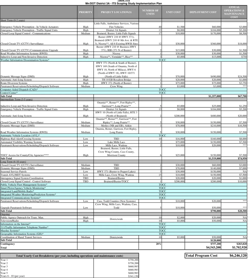
Cost EstimatesTable VI-2 includes cost estimates for the implementation of the recommended ITS technologies. Costs are shown in 2004 values. TOCC related programs are assumed to be already funded through the statewide TOCC program. The overall program cost is estimated to be about six million dollars, including annual operations and maintenance costs.
PRIORITY PROJECT LOCATION(S) NUMBER OF UNITS UNIT COST DEPLOYMENT COST
ANNUAL OPERATIONS & MAINTENANCE
COST
Short Term (0-2 years)
Emergency Vehicle Preemption - In Vehicle Actuators High
Little Falls, Ambulance Services, Various
Fire Vehicles 40 $1,500 $60,000 $3,000
Emergency Vehicle Preemption - Traffic Signal Units High District 3A Signals 13 $8,000 $104,000 $5,200
Closed Loop Signal Control - Communications Medium Brainerd, Baxter, Little Falls Signals 17 $10,000 $170,000 $8,500
Closed Circuit TV (CCTV) Surveillance High
Baxter (HWY 210 @ HWY 371), Brainerd (HWY 210 @ 8th Ave. & RTE
3), Nisswa**, All 8 Existing RWIS Sites 12 $30,000 $360,000 $18,000
Closed Circuit TV (CCTV) Communications Upgrade High
Baxter (HWY 210 @ Business HWY
371), BIR (371 N of Baxter) 2 $15,000 $30,000 $1,500
Road Weather Information Systems (RWIS) High Nisswa 1 $30,000 $30,000 $1,500
Inductive Loop and Non-Invasive Detection High Nisswa**, Verndale**, Rice** 3 $5,000 $15,000 $750
Weather Information Dissemination Systems*
Dynamic Message Signs (DMS) High
HWY 371 (North & South of Baxter), HWY 169 (South of Onamia, North of HWY 18, North of Milaca), HWY 6
(North of HWY 18), HWY 10/371
(North of Little Falls) 7 $70,000 $490,000 $24,500
Automatic Anti-Icing System High TH 10 EB Royalton Bridge 1 $20,000 $20,000 $1,000
Route Diversion Systems High HWY 371 (North of Baxter) 1 $75,000 $75,000 $3,750
Paratransit Reservations/Scheduling/Dispatch Software Medium Crow Wing 1 $3,000 $3,000 ***
Computer-Aided Dispatch (CAD)* Control Center*
Sub-Total $1,357,000 $67,700
Intermediate Term (3-5 years)
Inductive Loop and Non-Invasive Detection High
Onamia**, Remer**, Fort Ripley**,
Garrison**, Long Prairie** 5 $5,000 $25,000 $1,250
Emergency Vehicle Preemption - Traffic Signal Units High District 3A Signals 13 $8,000 $104,000 $5,200
Automatic Anti-Icing System High
HWY 10 (North of Little Falls), RTE 3
(North of Brainerd) 2 $200,000 $400,000 $20,000
Closed Circuit TV (CCTV) Surveillance Medium
Onamia**, Remer**, Garrison**, Fort
Ripley**, Long Prairie** 5 $30,000 $150,000 $7,500
Dynamic Message Signs (DMS) Medium Motley (NB and EB), Aitkin 3 $70,000 $210,000 $10,500
Road Weather Information Systems (RWIS) Medium
Onamia, Remer, Garrison, Fort Ripley,
Long Prairie 5 $30,000 $150,000 $7,500
Automatic Vehicle Location (AVL)*
Highway-Rail Alert/Crossing Systems Low TBD 10 $16,000 $160,000 $8,000
Automated Visibility Warning Systems Low Lake Mille Lacs 2 $75,000 $150,000 $7,500
Paratransit Reservations/Scheduling/Dispatch Software Low Mille Lacs, Wadena 2 $10,000 $20,000 ***
TOCC Access for County/City Agencies**** High
Brainerd, Baxter, Little Falls, Crow Wing County, Cass County,
Morrison County 6 $25,000 $150,000 $7,500
Sub-Total $1,519,000 $74,950
Long Term (6-10 years)
Closed Circuit TV (CCTV) Surveillance Medium TBD 2 $30,000 $60,000 $3,000
Dynamic Message Signs (DMS) Medium TBD 2 $70,000 $140,000 $7,000
Seasonal Service Patrols Low HWY 371 (Baxter to Pequot Lakes) 5 $30,000 $150,000 NA
Transit AVL/MDT Systems Low Mille Lacs, Crow Wing, Wadena 15 $10,000 $150,000 $7,500
Interagency Signal System Coordination TBD Brainerd/Baxter 1 $20,000 $20,000 $1,000
Closed Loop Signal Control - Control Software TBD Brainerd/Baxter/TOCC 1 $200,000 $200,000 $10,000
Public Vehicle Fleet Management Systems* Smart Plows/Agency Vehicle Monitoring* Integrated Land/Mobile Radio*
Integrated Weather Monitoring/Prediction Systems* Integrated Communications Systems*
Paratransit Reservations/Scheduling/Dispatch Software Low Cass, Todd Counties (New Systems) 2 $10,000 $20,000 ***
Upgrade Paratransit Software Low
Crow Wing, Mille Lacs, Wadena, Cass,
Todd 5 $10,000 $50,000 ***
Sub-Total $790,000 $28,500
Ongoing
Public Agency Outreach for Trans. Man. High 10 $2,000 $20,000 NA
Television/Radio High 10 $5,000 $50,000 NA
Information on the Internet*
511/Traffic Information Telephone Number* Mayday Systems*
Geographic Information Systems (GIS)*
Coordination of Rural Transit Services Medium Districtwide 10 $5,000 $50,000 NA
Sub-Total $120,000
Contingency 20% $757,200 $283,820
Total $4,543,200 $1,702,920
Total Program Cost $6,246,120
Year 1 $758,200
Year 2 $758,200
Year 3 $660,983
Year 4 $660,983
Year 5 $660,983
Years 6 - 10 (per year) $341,150
* Funded under existing Mn/DOT TOCC Program ** Part of RWIS Installation
*** Transit O&M Costs Programmed by Local Agencies **** Possible Future TOCC Access for Cities/Counties with Transit NOTE - All Costs Shown in 2004 Dollars
Table VI-2
Mn/DOT District 3A - ITS Scoping Study Implementation Plan
TOCC TOCC TOCC TOCC TOCC TOCC TOCC TOCC TOCC TOCC
Total Yearly Cost Breakdown (per year, including operations and maintenance costs)
TOCC Districtwide
TOCC TOCC
Several ITS efforts that are identified as being priority in this plan are expected to move forward as elements of broader statewide projects or programs such as the Transportation Operations and Communications Center (TOCC) project. Although these proposed efforts would not be pursued at the District level, they are considered integral to the overall vision of this District plan.
C.
Integration/Scalable OpportunitiesMany similarities exist between the rural areas of Minnesota and several technologies from the District 3A Scoping Study have been recommended in other areas of the state. Several initiatives that have been discussed could be implemented on a statewide or regional basis. Implementing the technology on a regional or statewide basis would be beneficial in many ways. Procurement of equipment would be more cost effective and compatibility between devices would be almost guaranteed. The learning curve for operations and maintenance would be drastically reduced by using knowledge from other districts that may have already implemented similar systems. The systems identified throughout the state for possible statewide or regional deployment include the following. (Initiatives recommended for implementation in District 3A in bold.)
Emergency Vehicle Operations
Rural Transit
Travel Information Awareness and Dissemination
Speed Reduction/Traffic Calming
RWIS Upgrades/Additional Installations
TOCC Deployment and Integration with other TOCCs or centers
CVO Traveler Information
Anti Icing
Automatic Vehicle Location (AVL)
Interagency Communications
Agency Agreement Documentation
Highway Railroad Intersection Safety and Train/Crossing Detection
Portable Dynamic Message Sign (PDMS) Deployment
D.
Funding AlternativesThe principal source of government funding for transportation-related projects in the past decade has been through the Intermodal Surface Transportation Efficiency Act of 1991 (ISTEA) and the Transportation Equity Act for the 21st Century (TEA-21) passed in 1998. ISTEA provided and authorized federal funding for highway, highway safety, public transit, and other surface transportation programs. TEA-21 has built on and continues the initiatives established by ISTEA and combines them with new initiatives. These initiatives seek to meet the challenges of improving safety as traffic continues to increase at record levels, while protecting and enhancing communities and the natural environment, and advancing economic growth through providing efficient, safe, and flexible transportation.
Specifically as it relates to ITS, TEA-21 established the ITS Deployment Program to facilitate the integrated deployment of ITS in the United States. The ITS Deployment Program includes two main components: the ITS Integration component and the Commercial Vehicle ITS Infrastructure Deployment component. In general, the ITS Integration component provides federal ITS funding for the integration and interoperability of ITS in metropolitan and rural areas; and, the Commercial Vehicle ITS Infrastructure Deployment component provides federal ITS funding to deploy Commercial Vehicle Information Systems and Networks (CVISN).
In addition to ITS funding programs under TEA-21, several of the following standard funding categories have also been used to fund ITS related activities:
1.
Government-Funded Programsa.
Congestion Mitigation and Air Quality Program (CMAQ)This funding category can only be applied to projects that do not expand highway capacity for single occupant vehicles and that have quality benefits in Clean Air Act non-attainment areas for ozone and carbon monoxide.
b.
National Highway System (NHS)The NHS funding category can be applied to any road defined by the State of Minnesota. Project types eligible for funding on these facilities includes: construction; reconstruction; maintenance and operational improvements; safety; traffic management; parking areas; carpool/vanpool projects; and bicycle/pedestrian projects. Projects on NHS routes must be included in the Transportation Improvement Program (TIP).
c.
Surface Transportation Program (STP)The STP funding category can be applied to any road classified as an urban or rural arterial, urban collector or rural major collector. Project types eligible for funding on these facilities includes: construction; reconstruction and maintenance of roadways and bridges; transit capital projects; safety projects; traffic monitoring, management and control projects; air quality related transportation control measures; and planning and management activities. Projects on STP routes in urban areas must be included in the Metropolitan TIP.
d.
STP – Set Aside for Safety Improvement ProgramThe overall objective of this funding category is to reduce the number and severity of accidents and decrease accident potential on all public roads other than interstates. This funding mechanism includes planning, implementation, and evaluation of safety programs and projects under processes developed by the state and local governments and FHWA.
e.
Traffic Impact Mitigation FundingThis category can be applied to highway construction projects that can cause traffic to divert to alternate routes. In many cases, diversion tends to occur on local streets near the construction area. Typically, construction projects designate funding to help mitigate or reduce the traffic impacts generated by the project. Re-timing of traffic signal systems, additional law enforcement, enhanced freeway patrols in construction zones, and additional traveler information are examples of traffic mitigation measures that have been utilized in other parts of the country.
f.
Other FundingOther potential government funding sources could include emergency government, Department of Natural Resources Hazardous Materials Program (DNR HAZMAT), Minnesota State Police and County Sheriff resource programs, and the state tourism program. These programs could assist with: enhanced freeway patrols; patrol vehicle push bumpers; accident investigation sites; computer-aided dispatch (CAD) and 911 enhancements; incident management legislation; and, traveler information programs.
2.
Public-Private PartnershipsPublic-private partnerships have been used to both leverage and increase funding resources for ITS projects. Some examples of potential private partners that have assisted with service patrols, traveler information, and communications networks located in other areas of the country are: utility and telecommunications companies; commercial radio and TV companies; trucking organizations; and insurance companies.
Beyond these ITS funds and alternatives, it is expected that partner agencies will continue to seek supplemental ITS funds from other normal federal funding programs and resource sharing opportunities such as those noted above. This approach is consistent with national trends towards “mainstreaming” ITS activities into the more traditional transportation project funding requests.
It should also be noted that national trends are also moving towards making provisions for federal funding of operations and management related activities. This is particularly relevant to District 3A because of the significant effort that will ultimately be involved in operating and maintaining the ITS. As such, partner agencies should stay abreast of any developments in this area in particular in order to maximize the potential for supplemental and future ITS funds.
E.
Operations and Management PlanThe success of the ITS will depend on the commitment of the partner agencies to provide adequate resources to operate and maintain the system. Typically, the focus is on the costs of constructing and installing the ITS elements and little attention is given to the follow-on operations and maintenance of the system. In addition, this problem has been magnified in recent years by the increasing complexity of the ITS components being implemented.
It is recommended that these documents be prepared by an ITS consultant using a process that would include such items as surveys, interviews, and meetings. These meetings would discuss partner expectations; evaluate alternative operational scenarios, strategies and control tactics; evaluate maintenance alternatives; and provide a neutral forum for resolving conflict and reaching a consensus on operational and maintenance-related issues.
The ITS Operations Plan would be written to provide guidance for the day-to-day operations of the ITS elements, and to define the jurisdictional roles and responsibilities of each partner agency. An ITS Maintenance Plan would be written to define the maintenance roles and responsibilities for each partner agency’s specific ITS components of the project. In addition to addressing
operational and maintenance procedures, these plans would need to address the staffing, training, and support equipment requirements of each agency.
1.
OperationsTOCC operations should be standardized on a statewide basis to maximize the effectiveness of the program and enable information sharing between centers. The TOCC program plans to act as a communications hub for the following services: emergency response, enforcement, incident management, transit services (where possible), maintenance operations, traffic management, and traveler information. TOCC operations staff will need to be proficient communicators for all of the services to be provided. Comprehensive training and an operations guide will provide resources and basic functional information for the operators. Local agencies involved with the operations should also be trained on the basic applications and limitations for the TOCC. The TOCC planned hours of operation are 24 hours a day, seven days a week. TOCC operators would continue their primary duties of answering 911 calls and communicating with state patrol field officers. The additional information available to the operators would enhance their ability to provide field officers with information. Increased capabilities would also allow dispatchers to communicate pertinent information to the media, traveling public, and other agencies.
2.
Maintenancea.
Design Modification/Configuration ManagementProblems with the design or operation of ITS often develop, or only become apparent, after implementation. As a result, a design modification can be required to correct a recurring problem or to update the ITS equipment to current design standards and specifications. Typical design modifications could include the addition or removal of special equipment, new software functions, changes in displays, configurations, or locations, and upgrading ITS equipment or communications system components. However, once a system has been placed in operation, no changes to the system should be made without assessing their impact on existing operations and maintenance. Policies and procedures should be established and followed to approve and document all changes to the equipment and system configurations – hardware or software.
b.
Preventative MaintenanceThis level of maintenance is the most labor intensive. However, it is also the most efficient and least intrusive on system operations. It typically consists of periodically testing the equipment to validate its performance, predicting and preventing system failures by routinely replacing expendable hardware, and cleaning the equipment and its enclosures. The intent of preventative maintenance is to keep the ITS components and equipment operating at their as-installed conditions. As a result, interruptions are scheduled to minimize their impact on system operations.
c.
Responsive MaintenanceWith responsive maintenance, agencies limit maintenance to only those systems experiencing problems and outages. This level of maintenance includes both field procedures used to restore operation as well as shop procedures to repair and rehabilitate the malfunctioning equipment. In general, responsive maintenance has six steps: 1) Notification; 2) Site Security; 3) Fault Isolation; 4) System Restoration; 5) Equipment & System Rehabilitation; and 6) Documentation. Depending on the nature of the problem and its severity, Steps 4 and 5 can be combined. Responsive maintenance will keep the system operating between the as-built and failed-system conditions. Each partner agency should have a plan describing acceptable responses in terms of staff and timeliness for every ITS subsystem and their major component.
These three levels of maintenance can be broken down further into functional classifications: local-control, system-control, and physical plant. Examples of local-control items include intersection vehicle-detectors, traffic signal interconnects, traffic signals and other ITS equipment hardware. System-control items include the communications backbone and local distribution, video surveillance subsystem, vehicle detection subsystem, dynamic message signs and their subsystem, local and distributed firmware, computer hardware, and software. The physical-plant includes, for example, furniture, the heating and air conditioning system, and the electrical power distribution, and telephone systems.
3.
Personnel ResourcesOver the last decade, the FHWA, in partnership with other transportation organizations (FTA, ITS America, etc.), has comprehensively investigated the staffing levels, personnel skills, and training requirements for ITS applications and traffic control systems. Their research has identified that a majority of ITS applications and traffic control systems are not operating at their full potential. They identified the predominant problems as:
• A lack of commitment to provide adequate funding and staffing for day-to-day
operations and comprehensive maintenance
• The staff’s lack of technical knowledge of how the ITS related hardware and software functions, as well as the general principles of traffic operations and how to use the ITS equipment
To ensure that the greatest benefit from the implementation of the ITS plan, adequate operational and maintenance staffing levels and expertise must be provided. Several ITS components will be new and current personnel will not have the time to operate and maintain these new ITS field devices and communications systems. In addition, maintaining the ITS system elements will require different skill-sets from those that are currently used for existing system operations. Accordingly, it is important that the partner agency staff be included in the discussions throughout the ITS design and deployment process. This will help to ensure that the appropriate knowledge will be provided on the operations and maintenance of all ITS components. Though the TOCC
Migration Plan identifies future needs for equipment and facilities, the plan fails to address the future staffing needs for the ITS program.
4.
TrainingThe new ITS element will require that the staff of the partner agencies be involved in a variety of new functions and responsibilities. Accordingly, these personnel will need to be trained on the ITS hardware, software, and communications systems, along with any algorithms that may be used, in order to perform their jobs in a capable manner. At the very least, staff must have a basic understanding and be knowledgeable and capable of working with those aspects of the ITS that directly interface with their agency’s operations. Therefore, it is recommended that operations, maintenance, and software training be conducted periodically throughout the ITS deployment and that it include all impacted employees.
To initiate this training, two recommended training sessions include the Incident Management Training Program sponsored by the FHWA and the ITS Peer-to-Peer Program sponsored by the FHWA, Federal Transit Administration, and Federal Motor Carrier Safety Administration. These sessions along with other training sessions will provide public sector transportation stakeholders with a convenient method to tap into the growing knowledge base of ITS experience and receive short-term assistance on operating and maintaining the ITS element. All of these ITS related training sessions should be videotaped for use by future employees. In addition, these videotapes should form the basis of an on going ITS training program for the partner agency staff.