Georgia State University Georgia State University
ScholarWorks @ Georgia State University
ScholarWorks @ Georgia State University
Geosciences Theses Department of Geosciences
Fall 12-18-2012
Design and Development of a Mineral Exploration Ontology
Design and Development of a Mineral Exploration Ontology
Hilal Sevindik Mentes
Follow this and additional works at: https://scholarworks.gsu.edu/geosciences_theses
Recommended Citation Recommended Citation
Sevindik Mentes, Hilal, "Design and Development of a Mineral Exploration Ontology." Thesis, Georgia State University, 2012.
https://scholarworks.gsu.edu/geosciences_theses/49
DESIGN AND DEVELOPMENT OF A MINERAL EXPLORATION ONTOLOGY
by
HILAL SEVINDIK MENTES
Under the Direction of Hassan A. Babaie
ABSTRACT
In this thesis, an ontology for the mineral exploration domain is designed and developed
applying the Protégé ontology editor. The MinExOnt ontology includes a formal and explicit
representation of the terms describing real objects, activities, and processes in mineral
exploration. The stages used for these activities have various vocabularies, which are
semantically modeled in this ontology with Web Ontology Language (OWL). The aim of the
thesis is to show how ontologies can be designed and developed to help manage and represent
geological knowledge. In addition to providing a general workflow for building the ontology,
this thesis presents a simple user guide for the used software, including Protégé, used for
ontology development, and Knoodl-OntVis, used for OWL visualization.
DESIGN AND DEVELOPMENT OF A MINERAL EXPLORATION ONTOLOGY
by
HILAL SEVINDIK MENTES
A Thesis Submitted in Partial Fulfillment of the Requirements for the Degree of
Master of Science
in the College of Arts and Sciences
Georgia State University
Copyright by Hilal Sevindik Mentes
DESIGN AND DEVELOPMENT OF A MINERAL EXPLORATION ONTOLOGY
by
HILAL SEVINDIK MENTES
Committee Chair: Hassan A. Babaie
Committee: Daniel Deocampo
Rajshekhar Sunderraman
Electronic Version Approved:
Office of Graduate Studies
College of Arts and Sciences
Georgia State University
DEDICATION
I dedicate this thesis to my precious husband, Dr. Yavuz Mentes for his infinite support
and encouragement in my life. He is a practical fixer, excellent investigator, career explorer, and
has a motivating personality. Also, he has a significant role for my geoscience career in the USA.
I owe him for where I am in my career right now and what I have gained so far. I am deeply
thankful to him for his patience and all his career advice that made me successfully tackle the
ACKNOWLEDGEMENTS
I would like to express my deep and sincere gratitude to the people who made this thesis
possible. It would not have been accomplished without their unlimited supports.
First and foremost, I would like to present my special thanks to my advisor Dr. Hassan
Babaie for his guidance, encouragement, and assistance. His experience and suggestions
motivated me from the beginning of this research until I finished writing of my thesis. My dream
of getting the Master’s degree would have been achieved without his trust and continuous
support.
My gratitude also goes to my Thesis Committee members, Dr. Daniel Deocampo and Dr.
Rajshekhar Sunderraman for their patience, encouragements, and invaluable comments. Their
recommendations on different aspects of my research helped me improve my thesis.
My special thanks to my officemates: Dickson M. Liadey, Rhoda Popoola, Ginny
Mauldin, and Federico Valencia for their support when I was dealing with my courses and
research and for the friendly working environment whieh they provided.
I would also like to thank my friends Tulin Bilen, Esma Kucukyavuz, Hayriye Cakmak,
Kezban and Gurkan Sokat, Sibel and Mustafa Kara, Hande Eren and Ibrahim Adiyaman, and for
their help to overcome the stressful days throughout my studies.
I would like to thank my mother-in-law Hava Mentes, father-in-law Muzaffer Mentes,
sister-in-law Yeliz Mentes for their great support throughout studies. My deepest gratitude goes
and Hanim Sevindik Bac, my little brother Muhammet Ali Sevindik and my brother-in-law Veli
Ozan Bac. This thesis would not have been possible without their support and love.
Words cannot express my appreciation and heartfelt gratitude to my precious husband,
Yavuz Mentes. He has been a part of me ever since we met. He gave his love to make everything
easier for me to complete this research. His support and encouragement was in the end what
TABLE OF CONTENTS
DEDICATION... IV
ACKNOWLEDGEMENTS ... V
LIST OF TABLES ... X
LIST OF FIGURES ... XI
CHAPTER 1: INTRODUCTION ... 1
CHAPTER 2: LITERATURE REVIEW... 4
2.1. Ontology ... 4
2.2. Types of ontology ... 6
2.3. Use and instantiation of ontology ... 11
2.4. Linked ontologies and data ... 13
2.5. Terminology... 14
CHAPTER 3: METHODOLOGY... 18
CHAPTER 4: MINERAL EXPLORATION ACTIVITIES ... 22
4.1. General steps taken during mineral exploration ... 22
4.2. Main steps taken during mineral exploration ... 25
4.2.1. Area selection ... 25
4.2.2. Target generation ... 26
4.2.4. Resource evaluation ... 28
4.2.5. Reserve definition ... 29
4.2.6. Extraction (Mining) ... 29
CHAPTER 5: MINERAL EXPLORATION DOMAIN ONTOLOGY ... 31
5.1. Domain ontology workflow ... 31
5.2. The role of the Mineral Exploration domain ... 33
5.3. Mineral Exploration domain ontology ... 35
5.3.1. Naming style for domain concepts ... 35
5.3.2. General description of the MineralExploration domain ... 37
5.3.3. UML diagrams for MineralExploration domain ... 42
CHAPTER 6: ONTOLOGY DEVELOPMENT WITH PROTÉGÉ ... 50
6.1. Building the Mineral Exploration Ontology ... 50
6.2. Classes ... 53
6.3. Object properties ... 62
6.4. OWL visualization with Protégé... 69
6.4.1. OWLViz ... 69
6.4.2. OntoGraf ... 73
6.5. OWL Reasoner ... 74
CHAPTER 7: OWL VISUALIZATION BY KNOODL - ONTVIS ... 77
8.1. Conclusion ... 92
8.2. Future work ... 93
REFERENCES ... 95
LIST OF TABLES
Table 5.1. The naming style for domain concepts. ... 35
Table 5.2. Examples for RDF triple statements of the MineralExploration ontology. ... 36
LIST OF FIGURES
Figure 2.1. Semantic Web for Earth and Environmental Terminology (SWEET) (Raskin,
2004). ... 7
Figure 2.2. SWEET ontologies and their relationships (Raskin, 2004)... 7
Figure 2.3. Class hierarchy of GeologicalStructure (Zhong et al., 2009). ... 8
Figure 2.4. Domain ontology for category Stream (Pundt and Bishr, 2002). ... 9
Figure 2.5. Composition and genesis relationship for ontologies (Lin and Ludascar, 2005). ... 10
Figure 2.6. Concept of ore body modeling based on borehole ore composites derived cross sectional method (Ma, 2010). ... 12
Figure 3.1. XML Schema diagram for Aquifer. Each connection shows input parameters and their properties with their types (decimal, string, float). ... 19
Figure 4.1. The exploration or prospect wastage curve (Marjoribanks, 1997) ... 24
Figure 5.1. Domain ontology workflow for the thesis project. ... 32
Figure 5.2. Visualization of ‘Exploration Geology’ as a subclass of ‘Applied Geology’ using OWLViz. ... 33
Figure 5.3. OWLViz class hierarchy showing the subclasses of the MineralExplorationStage class. ... 34
Figure 5.4. Class hierarchy in the MineralExploraion domain. ... 43
Figure 5.5. Partitive (meronomic) hierarchy in the MineralExploration domain.. ... 44
Figure 5.6. UML diagram showing the Mapping as a part of TargetGeneration class.. .. 45
Figure 5.8. UML diagram for GeophysicalSurvey as a part of TargetGeneration.. ... 47
Figure 5.9. UML diagram for RemoteSensing as a part of TargetGeneration. ... 48
Figure 5.10. UML diagram for TargetDrilling as a part of MineralExploration.. ... 49
Figure 6.1. Screenshot of the ‘Active Ontology’ tab in Protégé to create ontology name and
its annotations. ... 51
Figure 6.2. Screenshot of ontology annotations in Protégé to add extra information about
the ontology. ... 52
Figure 6.3. Screenshot of the ‘Classes’ tab in Protégé to add and edit classes. ... 53
Figure 6.4. Screenshot of the ‘Classes’ tab in Protégé, showing the ‘MinExOntClasses’ as
the topmost superclass instead of the ‘Thing’ class. ... 54
Figure 6.5. Screenshot of the ‘Classes’ tab in Protégé showing the Map class and its
subclasses. ... 56
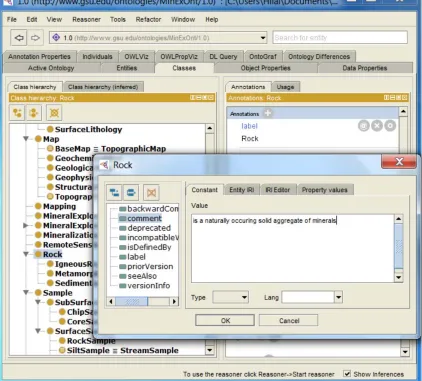
Figure 6.6. Screenshot of ‘Annotation’ in Protégé, showing the Rock class and its
annotations such as ‘label’ and ‘ comment’. ... 58
Figure 6.7. Screenshot of the ‘Classes’ tab in Protégé showing the BaseMap ... 59
Figure 6.8. Screenshot of the MinExOnt class taxonomy in Protégé showing ‘Class
Hierarchy’ and the list of classes in the MinExOnt Ontology. ... 61
Figure 6.9. Screenshot of the ‘Object properties’ tab in Protégé showing properties defined
under MinExOntTopObjectProperty in the ontology. ... 62
Figure 6.10. Screenshot of the ‘Object Properties’ tab in Protégé, showing the
Figure 6.11. Screenshot of the ‘Object Properties’ tab in Protégé, showing the logs
property as an object property with its ExplorationGeologist domain, and
Core range, and its loggedBy inverse property. ... 65
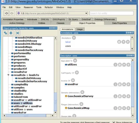
Figure 6.12. Screenshot of the ‘Object Properties’ tab in Protégé, showing the ‘Equivalent
To’, and ‘Inverse Of’ properties, and the domain and range for the uses
object property. ... 67
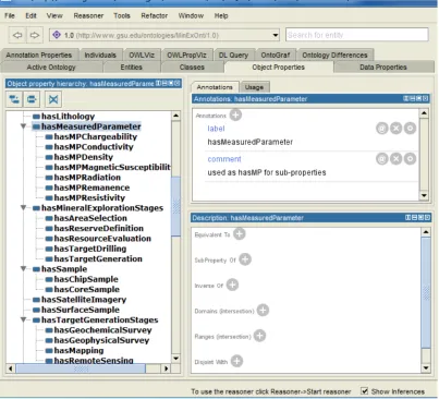
Figure 6.13. Screenshot of the taxonomy for the ‘MinExOnt’ object properties in Protégé,
showing all the named properties under the top
MinExOntTopObjectProperty object property. ... 68
Figure 6.14. Screenshot of the ‘OWLViz’ tab in Protégé, the class structure under the Map
class. ... 70
Figure 6.15. Screenshot of the ‘OWLViz’ tab in Protégé, showing the class structure under
the Sample class. ... 71
Figure 6.16. Screenshot of ‘OWLViz’ tab in Protégé, showing the class hierarchy of all the
classes in the MinExOnt Ontology. ... 72
Figure 6.17. Screenshot of ‘OntoGraf’ tab in Protégé, showing all kinds of relations
between the Sample class and its related classes ... 73
Figure 6.18. Screenshot of Protégé when no reasoned is selected. ... 75
Figure 6.19. Screenshot of ‘Reasoner’ in Protégé showing the asserted and inferred class
hierarchies of the ontology after FaCT++ and Hermit 1.3.6 reasoners are
used. ... 76
Figure 7.1. Screenshot of a Knoodl page showing a new community creation. ... 77
Figure 7.3. Screenshot of the Protégé editor showing the selection of an ontology format. . 79
Figure 7.4. Screenshot of the Knoodl page showing ‘Import a Vocabulary’ tab. ... 80
Figure 7.5. Screenshot of the Knoodl page showing a general view after uploading the ontology. ... 81
Figure 7.6. Screenshot of the Knoodl page showing the content under the ‘Overview’ tab. 82 Figure 7.7. Screenshot of the Knoodl page showing the ‘Graph’ option in order to get visualization. ... 83
Figure 7.8. Screenshot of the OntVis legend for ‘Graph’ diagram. ... 84
Figure 7.9. Screenshot of OntVis for the Sample class. ... 85
Figure 7.10. Screenshot of OntVis for the Sample class. ... 85
Figure 7.11. Screenshot of OntVis showing the URI for classes and properties without label annotation. ... 86
Figure 7.12. Screenshot of OntVis for the Map class with label annotations. ... 87
Figure 7.13. Screenshot of OntVis for the Map class with additional information displayed. ... 87
Figure 7.14. Screenshot of OntVis showing the ‘Property Tree’ on the left and the ‘Graph’ window on the right. ... 88
Figure 7.15. Screenshot of OntVis for the analyzedBy property and its domain and range. The related analyzes property and its annotations are also displayed. ... 89
Figure 7.16. Screenshot of OntVis showing the domain and range of the dealsWith property and its related property. ... 90
CHAPTER 1:INTRODUCTION
Geologists use various field and laboratory methods to explain and depict Earth history,
and to understand the processes that occur on the Earth. In a typical geological investigation,
geologists utilize primary information related to petrology, stratigraphy, economic geology,
structural geology, and other geological knowledge. Moreover, they rely on a wide variety of
available resources such as database, scientific articles offering geological knowledge, and
internal or external reports. The volume of these resources along with the knowledge geologists
have is growing very fast as knowledge progresses, and more data is being acquired with the
proliferation of sophisticated measuring and detecting devices. As the volume of the collected
data increases, a need to efficiently manage and represent the data becomes more obvious since
study of heterogeneous and unstructured knowledge is challenging, time consuming, costly, and
inefficient.
The solution is generated in a global architecture where semantic plays a significant role
to eliminate the obstacles originated from knowledge heterogeneity (Ameur et al., 2004). The
basis and structure of knowledge should be organized and managed with the Semantic Web
Technology, which is related to machine readable and understandable knowledge model –
‘ontology’. This knowledge modeling and data structuring is done by identifying and properly
defining a set of relevant concepts and relating them in the form of ontologies that characterize
the knowledge in a given application domain (Navigli and Velardi, 2004). There has been a
growing focus on Web Ontology Language (OWL) due to its ability to explicitly describe data
among humans by defining a common, controlled vocabulary allows knowledge to grow
effectively under control.
Knowledge, the sum of known facts in the domain, is used by various industries related
to geology, such as oil and gas, environment, hydrogeology, mining, and several others.
Geological knowledge is traditionally organized to be understood by the people who deal with
geology. In knowledge representation, the people who know the knowledge about a specific field
are called ‘domain experts’ in the field of knowledge representation. Thus, someone who has
enough knowledge and background about a specific geological domain can create the domain
ontology related to it. In this study, mining industry is selected to develop the ontology.
Mining industry mainly aims to find and create a target having valuable profits. This can
be achieved with comprehensive exploration studies. Exploration geology is a geological field
that applies diverse geological knowledge for mineral exploration and involves geological
studies for evaluation, management, and planning for future exploration and operational studies.
With the growth of population and increasing need for minerals, more mineral exploration
studies are carried out all over the world. In order to reduce exploration and production risks and
cost, companies use and maintain various software tools, at great costs, for ensuring the quality
of collected information, data analysis, and creating new knowledge. The knowledge, produced
as a result of processing and interpreting the acquired data is generally embedded and hidden in
technical reports, databases, and other types of files e.g., Excel spreadsheets. This has adverse
effects on the scientific growth of the domain. Thus, there is an acute need to reach a common
(i.e., consensual) way of formally and explicitly representing the geological mineral exploration
vocabularies of heterogeneous terms in different mineral exploration communities prevents
geologists from efficiently using and reusing their data in mining projects. Although it may seem
building the ontology plays a significant role solely for the business part of geology, it is
important to appreciate the value of ontologies for the continuing scientific growth in the field.
Thus, domain ontology applied for mineral exploration domain is useful not only for business
part of geological studies but also for the scientific research.
The aim of this thesis research is to show how ontologies focusing on OWL can be
designed and developed to help management and representation of geological knowledge and to
improve the use and integration of heterogeneous geological data. The Mineral Exploration
domain ontology provides a knowledge-based, semantically inter-related vocabulary
representing the knowledge about mineral exploration and explicitly formalizes the semantic
relationships between concepts, for example, of ore deposit and natural resource exploration.
Since there is a need to acquire a common way of formally and explicitly representing terms
about mineral exploration studies in mining industry, the stages taken during these activities are
applied for the ontology development. It also provides a simple user guide for the software,
including Protégé and Knoodl-OntVis, which are applied to develop ontology. The ontology
produced in this study is non-proprietary, open source, and open access, and therefore can be
CHAPTER 2:LITERATURE REVIEW
2.1.Ontology
Ontology is a machine-understandable knowledge model, which is built by explicit
(clear, open) specification of the real objects or abstract concepts and their relationships in a
specific domain. The term is borrowed from philosophy where ontology is a systematic account
of existence (Gruber, 1993). According to Gruber, ontology should effectively communicate the
intended meaning of the defined terms and relationships. It should be coherent, clear, and
designed to anticipate the uses of the shared vocabulary, i.e., built for pragmatics.
Describing a common, shared vocabulary allows researchers to share information through
integration of data. Ontology plays a significant role to make these machine interpretable
descriptions of basic concepts and relations among them. According to Noy and McGuinness
(2001), the reason why ontology is developed will be ‘to share a common understanding of the
information among people or software agents enables reuse of domain knowledge, make domain
assumptions, separate domain knowledge from operational knowledge, and analyze domain
knowledge’. In other words, it is used to more efficiently and formally share, reuse, and analyze
knowledge (not just data), and to identify its implicit assumptions. It also defines the concepts,
relationships, and other distinctions that are relevant for modeling a domain and plays an
important role in different aspects of information system development (Pundt and Bishr, 2002).
Discovery and integration of resources such as data, articles, and Web documents from
distributed data sets requires people know about the specific terminology and structure each
database uses, and map each term against the schema of each data source. This may be
many databases exist. Then, ontology can help computers to extract and aggregate information
originating from different data sources in an efficient manner (Zhong et al., 2009). This approach
helps people use their time efficiently. Instead of users searching for each of these terms in
different data source, computers can do it significantly faster with the help of ontology that
specifies those equivalent terms.
Ontology generates a common vocabulary that shows knowledge about a specific matter
and provides list of terms in the subject. This matter or subject is referred as a ‘domain’ in an
ontological terminology. The important thing creating ontology is ability to define relationships
between the terms in the vocabulary. For example, geological structures, deformation
mechanisms, stylolites, and pressure solution are ‘concepts’ in the Structural Geology domain,
and are represented by a class in this ontology. The class of ‘Stylolite’ is a type of geological
structure, and is represented as a subclass of the ‘Geological Structure’ class. Subclassing from
the general to more specific classes forms the class hierarchy. Classes may be related to each
other through properties. For example, stylolites are formed by the pressure solution deformation
mechanism, which may be stated by the ‘Pressure Solution forms Stylolite’ statement. The
‘forms’ property, therefore, represents the relationship between pressure solution deformation
mechanism and the stylolite (Zhong et al., 2009). These relationships provide a machine
readable, semantic connection between the terms.
In geoinformatic research, geosciences data providers, semantic web researchers, and
software developers collaborate on sharing topics of geoscience ontologies and language,
building geoscience data models, and developing Semantic web applications for knowledge
representation and management (Reitsma et al., 2009). In this way, common language in a
2.2.Types of ontology
Ontologies may be categorized as domain ontology and upper ontology. A domain
ontology (or domain-specific ontology) models the knowledge of a specific domain (field), or
part of the world. It represents the particular meanings (semantics) of terms as applied to that
domain. An upper ontology (or foundation ontology) is a model of the common objects that are
generally applicable across a wide range of domains (Navigli and Velardi, 2004). For instance,
NASA’s SWEET ontology (Figure 2.1) is an upper ontology, which defines general terms and
relationships. The scientific data collected during NASA’s earth observation missions, and
generated by NASA-sponsored Earth science research, are archived in a specific domain
ontology data across the United States (Keller et al., 2006).
There are many upper-level ontologies developed in the Earth Sciences. One of them is
the North American Geologic Map Ontology, which was generated by North American Data
Model Design Team under the directory of the North American Geologic Map Data Model
Steering Committee (NADMSC) with the aim of providing digital geological map database. It
includes controlled vocabularies for geologic relations, geologic events, geologic units, geologic
structures, earth materials, geologic processes, and geologic properties. (North American
Geologic Map Data Model Steering Committee, 2004). Another upper ontology example in
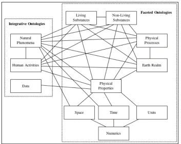
Earth Science is the Semantic Web for Earth and Environmental Terminology (SWEET)
(Raskin, 2004). Its ontology has broad and very coarse coverage in Earth Systems Science,
including concepts like space, time, Earth realms, physical quantities, phenomena, and events
Figure 2.1. Semantic Web for Earth and Environmental Terminology (SWEET) (Raskin, 2004).
Figure 2.2. SWEET ontologies and their relationships (Raskin, 2004).
[image:23.612.107.460.327.609.2]domain ontology. Some case studies related to ontology or knowledge based applications for
geosciences are listed below:
- Rock classification ontology (Struik, 2002).
- Safod Brittle Microstructure and Mechanisms Knowledge Base Ontology.
(http://safod.gsu.edu:8080/safod/).
- Structural geology ontology (Babaie et al., 2006).
- e-WOK HUB project including various ontologies in the domain of geology provides
capability of management of spatial information in an ontological database (Ameur et al., 2004).
- Geologic Age domain ontology.
- Ontology of fractures (Zhong et al., 2009). This study has some classes related to
fractures (Figure 2.3).
- Stream domain ontology for environmental monitoring using geographic information
systems (Pundt and Bishr, 2002). Figure 2.4 shows the relationships among the terms in stream
ontology.
- Geo-Ontology describes geological models for hydrocarbon exploration, production and
modeling of reservoir using geological and geophysical data (Perrin et al., 2005).
- Earth modeling domain ontology for geological site qualification as CO2 storage
(Rainaud et al, 2008).
- The ‘Gravity Contour Map’ ontology, used generally for geophysical studies
(Salayandia et al., 2006), is another example of the ontology application in geosciences.
- Grid based geological survey (Loudon and Laxton, 2007).
- GEON project including different domain ontologies. Lin and Ludascher (2005) discuss
the prototype system developed in the GEON project for exploring data sets, querying registered
data sets, and then integrating the maps at the end. The objective was to integrate available
geologic data sets to provide a web-based interactive geological map to find the location where
rock has a specified geologic age, composition, fabric, texture, or genesis property. They created
five ontologies for their study (Geologic Age, Genesis, Texture, Fabric, and Composition).
Figure 2.5 shows the relationship between the genesis and composition. It represents a part of
composition classification, which is calcium and limestone as a Sedimentary Rock and Marble as
a Metamorphic rock have this composition.
2.3.Use and instantiation of ontology
After ontology is developed, the controlled vocabulary can be reused, merged, and
integrated with various ontologies because of its interoperability with machine processible
format. Efficient utilization of software languages in ontological studies enables this
interoperability at high performance. Use of these existing ontologies can solve heterogeneity
problems for various domain knowledge (Sinha et al., 2010).
Ontology facilitates the identification of the vocabularies in a domain and provides
effective access to knowledge and data. The concepts or terms used in the ontology can be
populated with instances or individuals of classes and their attributes with values. It is a kind of
insertion of information into the knowledge base. Each agent can use their own data for the same
ontology. The data populated in the ontology adds more meaning for the structured knowledge.
There are various applications for ontological studies. One of them related to geological
knowledge base is mentioned in the research done by Xiaogang Ma in 2010. Part of this study is
about 3D modeling of ore bodies for mining studies (Figure 2.6). In the figure, (a) represents
classifying the significant assayed intervals in bold red along a borehole on a specific cross
section; (b) shows combining each borehole results through the section like whole 2D profile of
the section and creating composite intervals or composites; (c) represents making an
interpolation and converting 2D to 3D ore body; (d) shows a model of objects, attributes and
their relationships and represents connections among classes like BOREHOLE, MGINTERVAL,
COMPOSITE, CSECTION, OREBODY (Ma, 2010). This study is a good example for how
ontologies can be instantiated with values or other specific information. Figure 2.6 (d) shows
like borehole number, location coordinates, related project name, total depth and other required
information to identify a specific borehole. It can be variable and populated different for each
borehole. ‘MGINTERVAL’ and ‘COMPOSITE’ may contain grade values of several metals.
This shows a way how to relate a borehole in the beginning of mineral exploration studies to 3D
ore body at the end of mining extraction.
2.4.Linked ontologies and data
Information stored in the current world wide web (WWW) is reached with the help of
machines or computers. Their functionality is based on delivering and presenting the documents
or archives describing various knowledge on the web. However, people are supposed to connect
all the sources related to the topic and make an interpretation about it The Semantic Web, which
is developed by Tim Berners Lee, can extend the current web so that knowledge can be related
and linked to one another (Obitko, 2007). By doing this, computers can process the knowledge
on the web and make a connection among information to help humans analyze knowledge easily.
Linking ontologies provides effective information sharing among knowledge and reusing
via web-accessibility and interoperability. Then, knowledge can be widely used and accessed by
means of linked ontologies.
In order to transform various web documents, reports, papers, and other publications into
machine processible formats, linked data is used to make a connection among variable data in the
cloud (Babaie and Raj, 2012). Therefore, ontologies should be published on the web. Linked
data, which is a universal ontology-based data access, is generated by publishing and connecting
structured data in machine processible format. This provides accessibility for people who reach
other user’s knowledge and data stored in many places (Sacco and Passant, 2011). It is boundless
2.5.Terminology
The following terminology shows various terms related to ontology that are used
throughout this project.
Attribute: It is a property, feature, or characteristic of a class (Corcho et al., 2006). It provides
additional information for a class. For example, ‘Sample’ is a class having attributes for
identifying a specific sample, like Sample ID (numeric value), Sample Number (numeric value),
and Sample Type etc. These attributes provide specific information about a class. Also, ‘Rock’
as a class has several attributes like grain shape, grain size, texture and other properties.
Bidirectional relationship: Two-way relationship between two nodes both from A to B and from
B to A. For example, there are two relationships between ‘Laboratory’ and ‘Sample’. It can be
either ‘Laboratory analyzes Sample’ or ‘Sample analyzedBy Laboratory’.
Class: It is a concept or term or thing organized in taxonomies (Corcho et al., 2006). All classes
are subclasses of owl:Thing, which is top class. It may include individuals, instances of class. In
geology domain, ‘Mineral’, ‘Rock’, ‘Core’, ‘Geologist’ can be classes. ‘Geologist’ can be a
subclass of ‘Employee’ under the ‘Thing’.
Domain: It is a first component of the relation or a subject in RDF triple sentences (Corcho et al.,
2006). For example, ‘Exploration Company drills Drillhole’ in this sentence, first part of the
relation, which is ‘Exploration Company’ is a domain of this triple.
Also, ‘Domain’ can is the specific field of the study under the consideration in the ontology,
Edge or arc: It is a graph element or a line connecting nodes. It is shown in the schemas in the
UML diagrams.
Instance (Individual): It is an element or individual in ontology. Then ontology can be populated
with instances of classes and their attributes with values (Corcho et al., 2006). For example, if
the mining site is a class and Safford Mining Site in Arizona can be an instance.
Namespace: It is a collection of URIs in which every resource name is locally unique (Hoekstra,
2009). Two different communities may have same thing but this conflict can be eliminated using
unique URIs for each community. It also provides a way to qualify terms by associating them
with URIs. For example, ‘CoreSample’ class under MinExOnt ontology is a term having
namespace or URI like http://www.gsu.edu/ontologies/MinExOnt#CoreSample.
Node (Vertex): A record consisting of one or more fields that are linked to other nodes or
vertices. (Corcho et al., 2006). All concepts, in other words ‘classes’ in the ontology are
represented in nodes. Section 5.3.3 shows UML diagrams, including nodes.
Object: It is a part of RDF triple sentence (Subject-Predicate-Object) (Allemang and Hendler,
2008). ‘Technican prepares Sample’ is an example of triple sentence and ‘Sample’ is an object in
this sentence.
Ontology: It is a clearly, openly described concepts or terms and their relations with a machine
readable structure (Gruber, 1993). It is an explicit description of a specific topic or domain.
Predicate: The identifier for the thing that specifies properties of the entities in the subjects
(Allemang and Hendler, 2008). For example, in the triple sentence of ‘Technican prepares
Sample’, ‘prepares’ represents a predicate.
Property: It is an attribute of instance and describes the concepts in ontology. It can be Object
Property, making relations between instances of different classes to each other and connection
resource to resource or Datatype Property, making relations between instances of classes and
RDF literals and connection resource to datatype value (Allemang and Hendler, 2008).
Relation: Type of association between concepts of the domain. The ways in which classes and
individuals can be related to one another (Hoekstra, 2009). For example, in the triple sentence of
‘Technican prepares Sample’, there is a relation between subject and object with the help of
predicate.
Range: A concept or datatype object and a second argument of the relation (Corcho et al., 2006).
For example, ‘Exploration Company drills Drillhole’ in this sentence, ‘Drillhole’ is a range of
this triple.
RDF: It stands for Resource Description Framework and is a flexible way to design and
represent metadata on the web (Beckett, 2004).
RDF Triple: The basic building block for RDF. (Hoekstra, 2009). All resources (subjects,
predicates, or objects) on the Semantic Web are identified using unique Uniform Resource
Identifiers (URIs). For example, ‘Assay studiedBy ExplorationGeologist’ is a RDF triple
sentence in which ‘Assay’ is a subject, ‘studiedBy’ is a predicate and ‘ExplorationGeologist’ is a
Semantic Web: is a special form of ontology on the web and allows machines process the
knowledge on world wide web, connect and interpret it to help humans for interpretation. It is
also called as “web of data”. This term is produced by Tim Berbers-Lee
(http://en.wikipedia.org/wiki/Semantic_Web).
Subclass: A class that is derived from another class. For example, ‘Sedimentary Rock’ is a
subclass of ‘Rock’.
Subject: The identifier or first component of a RDF triple statement (Allemang and Hendler,
2008). For example, ‘Technician prepares Sample’ is an example of triple sentence and
‘Technician’ is a subject in this sentence.
Subsumption: (‘is-a’), the relationship between classes and subclasses or
generalization-specialization relation (Noy and McGuinness (2001). A subsumption is used to show a
connection between class and subclass. For example, ‘SurfaceSample’ is a subclass of ‘Sample’
and the connection between them is generated with ‘is-a’ connection.
UML Diagram: Unified Modeling Language diagram, a structure diagram showing classes, their
attributes and the relationships between classes (see section 5.3.3).
Unidirectional relationship: One way relationship between the two nodes either from A to B or
from B to A. For example, the sentence of ‘GravitySuvey hasMeasuredParameter Density’ in the
CHAPTER 3:METHODOLOGY
Ontology design and development in semantic works must be supported by software
engineering techniques (Brusa et al., 2006). These methods may be variable for different
implementations and provide different results after each technique. This chapter gives a main
idea about the methods used for design, development and visualization of ontology.
The Protégé editor, which is an ontology integrated development environment, is used to
develop the ontology in this research. Protégé is free and open-source ontology editor used by
system developers and domain experts to develop knowledge-based systems (Horridge et al.,
2007). It was developed by Stanford Medical Informatics at the Stanford University School of
Medicine (http://protege.stanford.edu/) with collaboration from several other agencies and is an
ontology editor as well as an open source Java tool that provides an extensible architecture for
the creation of customized knowledge-based applications.
Protégé provides loading and saving ontologies based on Semantic Web languages like
OWL (Web Ontology Language) and RDF (Resource Description Framework), defining logical
class characteristics, and editing and visualizing classes and properties. They are kind of
computer languages representing specific knowledge and used to create ontologies. According to
Berners-Lee, Semantic Web supported by World Wide Web Consortium (W3C) standard is a
web of data managed by directly or indirectly machines (Berners-Lee and Kagal, 2008). It can be
considered as a special form of ontology.
Ontology languages are formal languages that are used to construct ontologies in
computer science and allow the knowledge encoding about specific domains. There are a number
Wide Web, XML is easy to parse, its syntax is well defined and it is human and machine
readable. They allow users to define their own tags and attributes, define data structures, extract
data from documents and develop applications which test the structural validity of XML
document. It also has a system schema that can be used to define input parameters and
constraints (Mello and Xu, 2006). Figure 3.1 shows an example of XML Schema diagram for
Aquifer (Babaie and Babaei, 2005). Aquifer example shows input parameters and their
properties as an XML Schema.
Figure 3.1. XML Schema diagram for Aquifer. Each connection shows input parameters and their properties with their types (decimal, string, float).
RDF data model is developed by the W3C for the creation of metadata describing
resources on the web (Beckett, 2004). According to Heflin and Hendler (2000), ‘RDF has aim to
specify semantics for data based on the XML format in a standardized, interoperable manner and
to define a mechanism for describing resources that makes no assumption about a particular
application domain or the structure of a document containing the information’. It is written in
referred to (i.e., named) the URI (Uniform Resource Identifier), which provides universal
identifier to name these resources. The subject of the triple is a real-world object or abstract
concept. The object can be either an object or a literal or XML Schema data type such as string
and integer. The predicate is the property or relation that relates the subject and object resources.
Predicates define specific aspects, characteristics, attributes or relations used to describe a
resource. The object of the triple assigns a value for the property of triple’s subject (resources)
(Klyne and Carroll, 2004). For example, the domain statement: ‘Exploration geologist logs core’
is given by the ‘ExplorationGeologist logs Core’ RDF triple, in which ‘ExplorationGeologist’ is
the subject, ‘logs’ is the predicate, and ‘Core’ is the object. The ‘logs’ property makes a
relationship between the subject, which is ‘ExplorationGeologist’ and object, which is ‘Core’.
RDF is not enough to make a relationship among concepts. That’s why RDF Schema has
an important role on that point. The RDFS data model allows defining the relationships between
properties and other entities like resources. It also provides main elements for ontology
development to create sharable, controlled and extensible vocabularies. These main elements for
classes in RDFS are rdfs:class, rdfs:resource and rdf:property, and for properties are
rdfs:domain, rdfs:range, rdf:type, rdfs subclassOf, rdfs:subPropertyOf, rdfs:label, rdfs:comment
and rdfs:seeAlso, isDefinedBy. (http://www.w3.org/TR/REC-rdf-syntax/).
OWL, which stands for Web Ontology Language, is a language for Web knowledge
processing and mainly focused in this research. It is designed to process Web information and
easily read by machine. Moreover, it is a W3C standard, written in XML and built on the top of
RDF. RDF and OWL show some similarity, but OWL is more advanced and stronger. Since it is
written in XML, information in OWL can be transformed in different systems (W3C OWL
Web, OWL is more expressive because of its ability to describe knowledge of domain and to
represent machine readable content on the Web languages (Deliiska, 2007).
Protégé 4.2 beta (new version of Protégé) software supported by OWL is used to develop
the Mineral Exploration domain ontology in this thesis. In Protégé it is easy to create hierarchies
of classes and properties, and make a relationship among them. Since Protégé is a widely used
open source ontology development editor, it can be easily shared and extended with various
contributions by other developers (http://protege.stanford.edu/).
As an IBM product, Rational Rhapsody provides collaborative design and development
for systems engineers and software developers creating real-time or embedded systems and
software based on UML (Unified Modeling Language) (Rational Rhapsody Developer). This
proprietary modeling software is not open source for personal use. For this thesis, Microsoft
Office Visio 2010, which supports UML, is used to create class diagrams of the ontology.
Knoodl, which is a Distributed Information Management System, is used to visualize the
OWL classes and their properties instead of the graphs in Protégé. Combining semantic
technologies with traditional information management technology, Knoodl contains tools for
creating, managing, analyzing, and visualizing RDF/OWL descriptions, and features support
collaboration in all stages of these activities (http://www.knoodl.com/).
In summary, Protégé editor is used to develop the domain ontology in OWL. The design
of the ontology is done in Microsoft Visio applying UML diagrams of classes, properties and
relationships in a hierarchical perspective. Knoodl-OntVis is used to visualize the class structure
and relations. Different sources including Marjoribanks (1997) and Robert (2010) are used to get
better knowledge along with the author’s previous experience about the domain, which is about
CHAPTER 4:MINERAL EXPLORATION ACTIVITIES
Mineral exploration activity involves scientific process of locating valuable mineral,
which has a commercial value. Mineral deposits of commercial value are called ore bodies. The
goal of mineral exploration is to prove the existence of an ore body that can be mined at a profit
Marjoribanks (1997).
Mineral exploration processes occur in stages, with early stages focusing on gathering
surface data that are easier to acquire, and later stages focusing on gathering subsurface data,
which requires drilling data, detailed geophysical survey data, and metallurgical analysis. These
stages represent main steps for mineral exploration to get a commercial value of an ore body.
4.1.General steps taken during mineral exploration
Exploration activities play an important role in locating and defining a particular
economically mineable mineral commodity (ore) in a mineral province. There are important
factors in the economic recovery of minerals, which must be considered in order to get a
valuable ore deposit. According to Evans (1995), the principal steps in the exploration for an ore
body are the followings:
mineral exploration: to discover ore body
feasibility study: to prove its commercial viability
mine development: establishment of the entire infrastructure
mineral processing (ore dressing): milling of the ore, separation of ore minerals from
gangue, separation of the ore minerals into concentrates, e.g. copper concentrate;
separation and refinement of industrial mineral products
smelting: recovering metals from the mineral concentrates
refining: purifying the metal
marketing: shipping the product (or metal concentrate if not smelted and refined at the
mine) to the buyer, e.g. custom smelter, manufacture
According to Marjoribanks (1997), prospect exploration involves advancing through a
progressive series of definable exploration stages. These stages are defined and summarized
relative to the stages defined by Evans (1995). Although the steps are defined and expressed with
different terms and ways, they are generally almost the same. According to Marjoribanks (1997),
the stages in prospecting exploration are:
prospect generation
target generation
target drilling
resource evaluation
resource definition
feasibility studies
mining
The curves show how, for any given exploration program, the number of prospects decreases in
an exponential way through the various exploration stages (Marjoribanks, 1997). It shows the
importance of ‘Mineral Exploration’ in mining industry.
4.2.Main steps taken during mineral exploration
Based on literature research and author’s 5-year experience in a mining company, the
process of mineral exploration can be subdivided into the following six main steps based on the
references of Evans (1995), Marjoribanks (1997) and Moon et al. (2006):
area selection
target generation
target drilling
resource evaluation
resource definition
extraction or mining
4.2.1. Area selection
Area selection is the main step of mineral exploration activities to be worked on detailed
and important to generate new targets for the mineral exploration prospects. Dealing with general
literature survey and reviewing available digital data result in the selection of worthy areas. It
also applies different techniques, like basin modeling, structural geology, geochronology,
petrology, and geophysical and geochemical disciplines to make assumptions and find clues
between the known ore deposits and their physical forms (Evans, 1995). This work provides
geologist to see specific points from a general point of view. Selection of the most prospective
area in a mineral field, geological region helps in making it not only possible to find ore deposits,
that the company is interested in is most significant stage in mineral exploration since it shows
from where to be started to explore commercial value.
4.2.2. Target generation
Target generation involves certain stages, such as mapping, geochemical survey,
geophysical survey, and remote sensing. Mapping includes development of the geological,
topographical (base), geochemical, geophysical, and structural maps. Geological map focuses on
identifying and mapping outcrops, describing mineralization and alteration zones, and making
geological cross sections. In other words, it relies on the identification of rocks and minerals and
the understanding of the environment in which they form. It aims to find what rock types occur
at or close to the surface and how these rock types are related to each other, e.g., by defining
their boundaries, ages, and structure. Topographical map, which is a base map, depicts the
topographical features (contour, hill, stream, etc.). Geochemical map includes surface sample
locations and results, including analyses of rock, silt, and soil samples. Geophysical map depicts
the geology and results obtained from geophysical survey. Structural map shows the orientation
data (strike, dip, type, etc.) of bedding planes, faults, folds, joints and other structural features
(Marjoribanks, 1997). They are all gathered to be used for the interpretation in mineral
exploration studies.
Geochemical survey is a kind of sampling method in mineral exploration and results in
‘Assay’ after laboratory works. Exploration geochemistry has evolved from its early origins
using the chemistry of the environment surrounding a deposit in order to locate it (Evans, 1995).
A wide variety of geological material including rock, sediment, soil, water can be chemically
involve the geochemical analysis of geological materials, including rock, soil, and stream
sediment or silt sediment. In addition to these surface samples, any materials obtained from
drilling can be analyzed for the evaluation. The results of sampling may reveal patterns that point
to the location of an ore deposit, which may be present either underground or at the surface
(Marjoribanks, 1997). This survey provides physical results to be worked on for the further
interpretation and is used for identifying geochemical anomalies, which are used for geochemical
mapping.
Geophysical survey focuses on measuring physical characteristics (e.g., magnetism,
density, conductivity) of rocks at or near the Earth’s surface and uses surface methods to
measure these properties to designate a potential ore body. The measured values are then used to
compare with the values and models of known ore deposits (Marjoribanks, 1997). The results
obtained from this survey are gathered together to make a geophysical anomaly maps, which is a
good way for evaluation.
Remote Sensing is the collection of information about an object or area without being in
physical contact with it. According to the Evans (1195), ‘data gathering systems used in remote
sensing are photographs obtained from manned space flights or airborne cameras, and electronic
scanner or sensors such as multispectral scanners in satellites or airplanes and TV cameras, all of
which record data digitally’. Aerial photography and satellites allow people to work with modern
techniques. Aerial photography is used to sense the amount (quantity) of mineral in a particular
area. The mineral exploration company collects information such as tracks, roads, fences, and
habitation, as well as maps of outcrops, regolith, and vegetation cover across a region. Landsat
properties, but also spectra, which are beyond the visible (Marjoribanks, 1997). It is a modern,
direct way of detecting minerals and their alteration.
4.2.3. Target drilling
Target drilling is the process whereby rigs or some operated tools are used to make
boreholes to intercept an ore body. It can be done by contractors with more experienced
operators. This method is used to obtain very detailed information about rock types, mineral
content, and rock fabric, and the relationships between rock layers close to the surface and those
at depth (Marjoribanks, 1997). Then, subsurface geology in a particular area is evaluated after
the results are obtained. That indicates if the potentially economic resources are present or not.
In general, the purpose of drilling is to: determine the absence or presence of ore bodies,
veins, and other type of mineral deposit, define the volume of and depth to the ore body; estimate
reserve of ore body reservoir. Then, ore deposit is discovered before it is decided to be mined.
4.2.4. Resource evaluation
It is an evaluation of tonnage (volume) and grade (concentration or weight percent) of the
ore body. The volume is determined by using drill data to outline the deposit in the subsurface,
and by using geometric models to calculate the volume. The grade is the average concentration
determined from numerous assays of drill samples. The purpose of the resource evaluation is to
understand the possibility to expand the known size of the deposit and mineralization (Eggert,
2010). In this way, the economic standards of an ore body are obtained, which is needed for the
next step. This step should give an information or idea about proceeding of mineral exploration
results of grade and tonnage. In order to get an exact size, quality of the commercial mineral,
‘reserve definition’, which is next step of mineral exploration studies, is used.
4.2.5. Reserve definition
Reserve definition is important to transform a mineral resource into economic asset,
which is an ore reserve and find the answer if it is valuable or not. ‘Reserve’ is more intensive,
technical, and well characterized term with its exact quality and size relative to ‘Resource’. Also,
reserve estimation may be changed over time because of the assessments during and after the
mining. The main purpose of this stage is the making decision on the techniques just before
extraction as a result of the results. It includes technical, economic evaluation, geotechnical
assessment, and engineering studies of the rocks surrounding the deposit to determine the
potential parameters of proposed open pit or underground mining methods (Eggert, 2010). At the
end of this process, a feasibility study is published, and the ore deposit is supposed either
uneconomic or economic. At this stage, a decision is made whether to mine the mineral deposit
from the surface, called as ‘open-pit mining’, or by tunneling, called as underground mining
(Marjoribanks, 1997). Then, everything gets ready for mining to get a sustainable profit.
4.2.6. Extraction (Mining)
The main purpose of mineral exploration activities is to find valuable minerals to be
mined or extract and to get a profitable and beneficial sale of mineral commodities. Extraction is
the last stage of mineral exploration activities and mining engineers have a crucial role at that
point to extract the commercial mineral from the ground. It also includes plan, design and
the decision whether the mineral is mined with surface or subsurface mining, more detailed
studies are done at this stage. After mining, metallurgical processes start up for transformation of
CHAPTER 5:MINERAL EXPLORATION DOMAIN ONTOLOGY
5.1.Domain ontology workflow
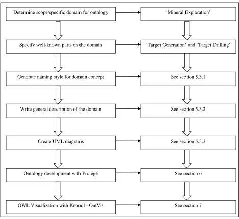
Figure 5.1 represents the workflow for the Mineral Exploration domain ontology project.
The study starts with the determination of the specific domain for ontology, which is in this
study is Mineral Exploration. Since it is too broad subject, two well-known parts of this domain,
which are Target Generation and Target Drilling are focused and discussed in more detail
throughout this thesis. The next step is generating a naming style for the ontology, which is
explained in section 5.3.1. It is used to define the terms of the RDF triple statements which are
used in the next step. Writing a general description of the Mineral Exploration domain is another
part of this study (see section 5.3.2). In this step, all rules about naming style are applied to the
RDF sentences generating the whole ontology. The UML diagrams are then created in order to
systematically show the relationships between the subject and object classes (see section 5.3.3).
The last part of this thesis describes the ontology development process with Protégé, and
Figure 5.1. Domain ontology workflow for the thesis project.
Determine scope/specific domain for ontology
Specify well-known parts on the domain
Generate naming style for domain concept
Write general description of the domain
Create UML diagrams
‘Mineral Exploration’
‘Target Generation’ and ‘Target Drilling’
See section 5.3.1
Ontology development with Protégé
See section 5.3.2
See section 5.3.3
See section 6
5.2.The role of the Mineral Exploration domain
Economic geology is a field that helps us to understand Earth’s natural resources, such as
minerals, petroleum, and coal. Exploration geology, or mineral exploration, is a sub-discipline of
economic geology. Figure 5.2 shows part of the Geology class hierarchy using OWLViz.
According to this hierarchy, Hydrology, Structural Geology, Economic Geology, Environmental
Geology and Engineering Geology are subclasses of Applied Geology, is a subclass of Geology.
The subsumptive relationship between classes and subclasses is shown with an ‘is-a’ connector,
which is a relation that points from a specialized class to the more general class. According to
Noy and McGuinness (2001), a subclass represents a concept that represents a class which is a
‘kind of’ a supereclass above it in the hierarchy. For example, the Silicate subclass is a kind of
the Mineral class. Mineral is the superclass of the Silicate class.
Figure 5.2 also shows the class hierarchy that represents the broad aspects of this project.
The specific focus of this thesis project is on the Exploration Geology class, which will be
modeled in the following sections. In the Protégé 4.2 beta editor, in which the ontology is built,
the initial OWL project is given the following URI:
http://www.semanticweb.org/ontologies/2011/10/ExplorationGeology.owl, which stands for
Mineral Exploration ontology. All classes and subclasses of the MineralExploration ontology
are defined under the owl:Thing, which is the superclass of everything.
Mineral Exploration is a broad field, and for the scope of this thesis project, only part of
it was modeled, which includes the area selection, target generation, target drilling, resource
evaluation, and resource definition stages. Figure 5.3 shows the OWLViz class hierarchy for the
classes and subclasses of the MineralExplorationStage class.
5.3.Mineral Exploration domain ontology
In this study, Mineral Exploration is the domain name for the ontology which is built in
this thesis project. The Target generation and target drilling are the two stages which are defined
in the ontology. These stages are carried out once a prospect has been identified or an area
selection has been done.
5.3.1. Naming style for domain concepts
The rules for the naming style for the Mineral Exploration domain are given in Table 5.1.
Table 5.1. The naming style for domain concepts.
Triple parts Type Type Font Letter Style Example
Subject Class Simple Arial
first letter is in
upper case Employee
Compound upper CamelCase ExplorationCompany
Predicate Property Simple Arial lower case describes
Compund lower camelCase hasPart, doneBy
Object
Class Simple Arial
first letter is in
upper case Employee
Compound upper CamelCase ExplorationCompany
Attribute Simple
Arial-italic
lower case easting
Compound lower camelCase holeID, startDate
The subject part of the RDF statement is always a class, and can be either simple or
compound. If it is simple, its first letter is only capitalized, e.g., Employee, Sample. If it is a
compound class, it is given in the upper CamelCase style, in which the first letter of each word is
written in the upper case, e.g., ExplorationCompany, TargetGeneration. The predicate is a
property, and can be either simple or compound. If it is a simple name, it is given in the lower
camelCase, in which the first letter of the first word is in the lower case but the beginning of all
other words in the compound name are in the upper case, for example, hasPart, doneBy,
hasEmployee. The object is either a class or an attribute (datatype) and can be either simple or
compound. If the object is a simple class, it is given in Arial font and only its first letter is
capitalized, e.g., Employee, Sample. If the object is a compound class, it is given in Arial font
and upper CamelCase style, e.g., ExplorationCompany, TargetGeneration. If the object is a
simple attribute, it is given in Arial-Italic font and lower case letter style, e.g., easting,
elevation. If the object is a compound attribute, it is given in Arial-Italic font and lower
camelCase letter style, e.g., holeID, startDate.
Each RDF triple statement is made up of a subject, predicate, and an object. Subject and
object are resources, and predicate (property) connects these resources together. All these
relationships will be described in more detail in the ontology development section. The following
table shows some examples of the RDF triple statements of the ontology (Table 5.2).
Table 5.2. Examples for RDF triple statements of the MineralExploration ontology.
Subject Predicate Object
ExplorationGeologist dealsWith Mapping
SurfaceLithology describes Rock
ExplorationCompany has Employee
Employee worksFor ExplorationCompany
MineralExploration performedBy ExplorationCompany
Sample sampledBy ExplorationGeologist
The relationship between subject and object can be either unidirectional or bidirectional.
Table 5.3 gives examples regarding these kinds of relationships between subjects and objects.
According to the Table 5.3, while number 1 and 2 represent bidirectional relationships, number 3
and 4 show unidirectional relationships.
Table 5.3. Examples of bidirectional (#1 - 2) and unidirectional properties (# 3 - 4).
# Subject Predicate Object
1 ExplorationGeologist logs Core
Core loggedBy ExplorationGeologist
2 Laboratory analyzes Sample
Sample analyzedBy Laboratory
3 GravitySurvey hasMeasuredParameter Density
4 CoreSample takenFrom Core
5.3.2. General description of the MineralExploration domain
Mineral exploration is a process to get a valuable profit from a mine, or to take place as
part of a strategy to locate and define a particular economically mineable mineral (Marjoribanks,
1997). According to the general point of view about mineral exploration, there are five steps to
complete mineral exploration studies. In this section, activities in the mineral exploration
domain are given in RDF triple statements. For example, MineralExploration has
MineralExplorationStages, which are AreaSelection, TargetGeneration, TargetDrilling,
ResourceEvaluation and ResourceDefinition. In a factored out fashion, the RDF triples of
hasTargetDrilling, hasResoruceEvaluation, hasReserveDefinition). These are the main
steps taken during mineral exploration studies and each one has a detailed workflow. The
TargetGeneration also has several TargetGenerationStages which are Mapping,
GeochemicalSurvey, GeophysicalSurvey, and RemoteSensing. In short hand, these are
more formally stated as: TargetGeneration has (GeochemicalSurvey,
hasGeophysicalSurvey, hasMapping, hasRemoteSensing) (Figure 5.5). AreaSelection is
the first step which is taken to start and explore new targets with potential for valuable minerals.
Since this step is assumed to be already done for this project, it is not discussed in detail. More
information about this step is mentioned at Section 4.2.1.
MineralExploration is performedBy an ExplorationCompany, having specific
companyName, companyAddress, and companyPhone. ExplorationCompany has many
Employees, having employeeID, employeeName, employeeStatus, and employeeSalary
(or Employee worksFor ExplorationCompany). ExplorationGeologist, who is an Employee
in the company, dealsWith Mapping. (or Mapping is doneBy ExplorationGeologist). Map is
a productOf Mapping and has different kinds, which are GeologicalMap, BaseMap or
TopographicalMap, GeochemicalMap, StructuralMap, and GeophysicalMap.
GeologicalMap is important for identifying outcrops and describing lithology and
mineralization. It aims to find what rock types occur at or close to the surface and how these rock
types are related to each other, e.g., by defining their boundaries, age, and structure.
GeologicalMap has SurfaceLithology and SurfaceAlteration. SurfaceLithology and
DHLithology (DownholeLithology or SubSurfaceLithology) are Lithology which describes
Rock and is determinedBy ExplorationGeologist. Rock has types, which are IgneousRock,
(DownholeAlteration) are Alteration and describe Mineralization. GeophysicalMap is
utilizedFor GeophysicalSurvey. GeochemicalMap is usedFor GeochemicalSurvey.
StructuralMap has GeologicalStructure, which can be BeddingPlane, Fault, Joint, or Fold.
Each one has specific projectID, easting, northing, type, strike, and dip (Figure 5.6).
GeochemicalSurvey is a kind of sampling and used for finding geochemical anomalies,
which are used in geochemical mapping. Geochemical methods involve the collection and
geochemical analysis of geological materials, including rock, soil, and stream sediment (silt
sediment). GeochemicalMap has SurfaceSample, which is a Sample (having specific
projectIDand sampleType), and can be RockSample, SoilSample, SiltSample
(=StreamSample) and is sampledBy ExplorationGeologist, preparedBy Technician, and
analyzedBy Laboratory, and then resultsIn (=leadsTo) Assay, studiedBy
ExplorationGeologist. RockSample has specificrSID, rSEasting, rSNorthing, rSSampler,
andrSComment. SoilSample has specificsSID, sSEasting, sSNorthing, sSSampler, and
sSComment. SiltSample has specific stSID, stSEasting, stSNorthing, stSSampler,
stSComment. SurfaceAssay, which is an Assay (information about geochemical analyses)
has specificprojectID, labID, sSampleID, sAssayID, sEasting, sNorthing, sAssay, and
sResults (for Au, Ag, Cu, Mo etc). SurfaceEvaluation needs SurfaceAssay to evaluate
surface geochemical data (Figure 5.7).
Geophysicist, who is an Employee, manages GeophysicalSurvey of
TargetGeneration under MineralExplorationStages (GeophysicalSurvey is managedBy
Geophysicist). This survey is important for interpretation and must be utilizedFor