www.atmos-meas-tech.net/8/3355/2015/ doi:10.5194/amt-8-3355-2015
© Author(s) 2015. CC Attribution 3.0 License.
Accuracy of retrieving temperature and humidity profiles by
ground-based microwave radiometry in truly complex terrain
G. Massaro1, I. Stiperski2, B. Pospichal3, and M. W. Rotach2 1Twist-Off Srl, Padua, Italy
2Institute of Meteorology and Geophysics, University of Innsbruck, Austria 3Institute for Meteorology, University of Leipzig, Germany
Correspondence to: G. Massaro ([email protected])
Received: 3 February 2015 – Published in Atmos. Meas. Tech. Discuss.: 2 March 2015 Revised: 18 July 2015 – Accepted: 3 August 2015 – Published: 19 August 2015
Abstract. Within the Innsbruck Box project, a ground-based microwave radiometer (RPG-HATPRO) was operated in the Inn Valley (Austria), in very complex terrain, between September 2012 and May 2013 to obtain temperature and hu-midity vertical profiles of the full troposphere with a specific focus on the valley boundary layer. In order to assess its per-formance in a deep alpine valley, the profiles obtained by the radiometer with different retrieval algorithms based on dif-ferent climatologies are compared to local radiosonde data. A retrieval that is improved with respect to the one provided by the manufacturer, based on better resolved data, shows a significantly smaller root mean square error (RMSE), both for the temperature and humidity profiles. The improvement is particularly substantial at the heights close to the moun-taintop level and in the upper troposphere. Lower-level inver-sions, common in an alpine valley, are resolved to a satisfac-tory degree. On the other hand, upper-level inversions (above 1200 m) still pose a significant challenge for retrieval. For this purpose, specialized retrieval algorithms were developed by classifying the radiosonde climatologies into specialized categories according to different criteria (seasons, daytime, nighttime) and using additional regressors (e.g., measure-ments from mountain stations). The training and testing on the radiosonde data for these specialized categories sug-gests that a classification of profiles that reproduces mean-ingful physical characteristics can yield improved targeted specialized retrievals. A novel and very promising method of improving the profile retrieval in a mountainous region is adding further information in the retrieval, such as the sur-face temperature at fixed levels along a topographic slope or from nearby mountaintops.
1 Introduction
Precise knowledge of the temperature and humidity structure of the atmosphere is essential not only for numerical weather prediction but also for the study of small-scale phenomena within the atmospheric boundary layer. Especially in com-plex terrain the boundary layers are still a topic of intense re-search, and the information about the vertical profiles, such as temperature and humidity, as well as their temporal evo-lution is particularly valuable (e.g., Rotach and Zardi, 2007). For this latter topic the temporal scales of minutes and spa-tial scales on the order of few tens to hundreds of meters are required.
data for 2 years, finding a root mean square error (RMSE) larger than 1.5 K at ground level. Thus, the accuracy of pas-sive remote sensing from satellites is too poor to be useful for studying boundary layer evolution.
On the other hand, ground-based remote sensing can pro-vide valuable information on the temperature and humidity structure of the lower troposphere. Methods using passive microwave radiometry have rapidly developed within the last decade when radiometers became commercially available. The measurement principle of a ground-based passive ra-diometer is measuring the radiation emitted by the atmo-spheric constituents (oxygen, water vapor, cloud droplets). Unlike infrared spectrometers that are able to produce verti-cal profiles only under clear-sky conditions due to strong liq-uid water absorption, a microwave spectrometer operates un-der almost all conditions (Löhnert et al., 2009) and is there-fore more appropriate for long-term monitoring of a valley atmosphere. One of commercially available radiometers is the RPG-HATPRO (Humidity And Temperature PROfiler) manufactured by Radiometer Physics GmbH (Rose et al., 2005). Statistical algorithms are used to retrieve humidity and temperature vertical profiles from the observed bright-ness temperatures. These retrieval algorithms exploit a lo-cal history of pressure–temperature–humidity profiles by us-ing a multiple regression approach followus-ing Löhnert and Crewell (2003) and Crewell and Löhnert (2007). Other train-ing data have been proposed. For example, Güldner (2013) introduced a new approach for the retrieval development, namely using data from the COSMO numerical weather pre-diction model (Steppeler et al., 2003). He showed that with this approach retrieved profiles almost reach the quality of those based on a radiosonde training data set. An additional advantage of such an approach is that data for retrieval are available “always and everywhere” (at each grid point of an operational model). However, using model data introduces additional uncertainty especially in complex terrain due to grid resolution and steep(er) slopes as well as finite forecast-ing skill.
The advantages of profiles derived from passive mi-crowave observations over radiosonde data, beyond the eco-nomic convenience, are their high temporal resolution (on the order of 1 min or less), their vertical resolution com-parable to current operational numerical weather prediction models and their ability to operate under all weather condi-tions, because clouds are semi-transparent for the microwave frequency range, with the exception of precipitation (Löh-nert et al., 2009). Crewell and Löh(Löh-nert (2007) compared RPG-HATPRO observations at Lindenberg (Germany) with data from 80 nearby radiosondes over flat terrain. Löhnert and Maier (2012) did a 3.5-year statistical comparison be-tween 2107 radio soundings and RPG-HATPRO tempera-ture profiles at the lowland station of Payerne (Switzerland). They found accuracies between 0.4 and 0.8 K in the lowest 500 m, gradually deteriorating with height (1.2 K at 1200 m and 1.7 K at 4000 m above ground).
In complex terrain, Sanchez et al. (2013) operated a MP-3000A microwave radiometer in Sierra Guadarrama (Spain). Comparison with radiosondes launched at a distance of 50 km provided accuracies of about 2 K in the lower tropo-sphere. A MTP-5HE (by ATTEX) was used in the Bergen Valley (Wolf et al., 2014) in order to obtain temperature pro-files and compare them with 1-year measurements from two automatic meteorological stations, located at the ground and on a mountain about 550 m above the valley floor; they ob-tained an RMSE of 0.2 and 0.8 K for the two stations, re-spectively. Overall, a thorough assessment of a passive tem-perature profiler in complex terrain using close-by radioson-des seems to be missing. Furthermore, operation of a pas-sive microwave profiler in a deep valley raises the question as to what the potential impact of slopes in the immediate surrounding of the profiler might be. While the atmospheric temperature profile is variable in time (what is, of course, the target of the observations) the ground has usually a larger thermal inertia than air, thus potentially degrading the statis-tical retrieval algorithm of the profiler.
Regarding the performance of retrieving absolute humid-ity profiles, Löhnert et al. (2009) compared the absolute hu-midity profiles obtained from simulated measurements by such a radiometer with radiosonde data at the aerological station of Payerne. They found an RMSE on the order of 0.8 g m−3 in the lowest 500 m, around 0.7 g m−3at 1200 m and about 0.4 g m−3 at 4000 m above ground. Sanchez et al. (2013) found comparable accuracies for more complex terrain.
ground-based radiometer in complex terrain. Unfortunately, scans in different azimuth directions needed for obtaining a 3-D-temperature field are not possible in the present envi-ronment, since the instrument would soon have the nearby mountains in its direct optical path if it pointed under lower elevation angles towards north or south. With this in mind we wish to examine the possibility of improving the retrieval algorithm by including additional regressors, such as temper-ature observations along the slopes or on mountaintops.
Section 2 describes the basics of microwave radiome-try, radiative transfer, as well as the retrieval algorithms. In Sect. 3 the experimental setup is explained. The comparison between the profiles obtained from the microwave radiome-ter by applying different retrieval algorithms with radiosonde data for 84 days between September 2012 and May 2013 is presented in Sect. 4. A final discussion and open challenges are given in Sect. 5.
2 Microwave radiometry and retrieval development 2.1 Radiative transfer
In the microwave region of the electromagnetic spectrum (about 3–300 GHz, 1 mm to 10 cm wavelength), a ground-based receiver measures the thermal radiation emitted by the atmospheric constituents, especially O2 and H2O (the lat-ter in both gaseous and liquid form), and the cosmic back-ground radiation. With the assumptions of a plane-parallel atmosphere, thermodynamic equilibrium and negligible scat-tering (valid for frequencies below 90 GHz in the absence of rain) the brightness temperature Tb at the ground for each frequencyνis given by
Tb(υ)=Tb0e−τ (st)+ st
Z
0
α (s) T (s) e−τ (s)ds, (1)
withsbeing the path length,αthe absorption coefficient and
τ the optical depth. The first term in Eq. (1) originates from the cosmic background radiation attenuated over the path of propagation. The second term represents the integral from the top of the atmosphere to the ground of the emission by atmospheric gases and hydrometeors in a particular atmo-spheric layer that is attenuated by the underlying atmoatmo-spheric layers (Janssen, 1993).
2.2 Retrieval algorithms for atmospheric quantities In order to obtain atmospheric quantities from observed brightness temperatures, the radiative transfer equation (Eq. 1) has to be inverted. However, since this is an ill-posed problem, it cannot be solved analytically. Therefore, statisti-cal methods have to be applied, such as multiple regression or neuronal networks. The algorithms we use for this work are based on a set of training data from historical profiles
(climatology) and allow retrieval of vertical profiles of tem-perature and humidity (Löhnert and Crewell, 2003). In our case, this set of training data consists of profiles of pressure, temperature and relative humidity (p–T–RH) obtained by ra-diosonde measurements. Under the assumption of a horizon-tally homogeneous atmosphere, a profile consists of several layers characterized by their proper temperature; thus the in-tegral in Eq. (1) can be converted into a sum. TheoreticalTb from the training set of radiosonde data is computed with a non-scattering radiative transfer model using gas absorption following Rosenkranz (1998) and the liquid cloud absorption according to Stogryn et al. (1995). Liquid clouds are assumed to exist above a 95 % relative humidity threshold with a tem-perature warmer than 243.15 K. In this case the liquid water content is calculated following the modified adiabatic model by Karstens et al. (1994).
A linear regression between these modeledTb and tem-peratures at some pre-defined atmospheric layers can then be performed. These regression coefficients andTbmeasured by the radiometer are then used to retrieve the atmospheric pro-files also in the absence of radio soundings. The output (Outi) of the retrieval algorithm, which is the temperature or the ab-solute humidity of theith atmospheric layer, is related to the measuredTbat thej frequencies in a linear and a quadratic term, respectively, and to a number of additional regressors (such as surface pressure or temperature sensors) that are in-troduced to potentially improve the statistical performance. The regression equation is given by Eq. (2):
Outi=COsi + X freq,j
CTb,1ij Tbj+
X
freq,j
CTb,2ij Tb2j
+ X
sens,j
CSr,1ij Srj+
X
sens,j
CijSr,2Sr2j, (2)
whereCOsi is an offset,CTb,1ij andCTb,2ij are the coefficients for the linear and quadratic terms, respectively, of the brightness temperatures Tbj, CSr,1ij andC
ij
Sr,2 are the coefficients (lin-ear and quadratic, respectively) for the sensors at the ground level Srj and the indexiruns over several layers of the at-mosphere. The vertical grid (Table 1) for which the profiles are retrieved depends on vertical resolution of the radiometer and is gradually getting coarser with height. In our case, the elevation angles used for scanning are 90.0◦, 30.0◦, 19.2◦, 14.4◦, 11.4◦, 8.4◦, 6.6◦, 5.4◦, 4.8◦, and 4.2◦.
Figure 1. View from the west to the city of Innsbruck. In the foreground the airport is visible where the radio soundings are launched and
the approximate position of the HATPRO on the roof of the university building with the scanning direction towards the east is indicated. The red triangle denotes the Patscherkofel mountaintop station.
Table 1. Height grids of the temperature/humidity profile retrieval, expressed in meters over the instrument.
Height grids of profiles retrieved from RPG-HATPRO
0, 10, 30, 50, 75, 100, 125, 150, 200, 250, 325, 400, 475, 550, 625, 700, 800, 900, 1000, 1150, 1300, 1450, 1600, 1800, 2000, 2200, 2500, 2800, 3100, 3500, 3900, 4400, 5000, 5600, 6200, 7000, 8000, 9000, 10 000
Only the surface pressure is used as an additional regressor. Table 2 summarizes the main characteristics of the RPG al-gorithm.
2.3 Improving the retrieval algorithm
The first step in enhancing the retrieval performance is to use a more statistically robust set of radiosonde data. The latter are now used at their full temporal resolution: 10 s for the soundings before 2009 and 2 s for the later ones, correspond-ing to a height resolution of 40–50 and 8–10 m, respectively. Additionally about 130 daytime soundings from the MAP (Bougeault et al., 2001) and ALPNAP (Harnisch et al., 2009) international projects, launched between 1999 and 2005 from the airport of Innsbruck, are used to include information on the diurnal variation. A total number of 3157 radiosonde pro-files passed the quality check (cf. Sect. 3.2) and are used in the radiative transfer model. In addition, the best choice of re-gression (linear vs. quadratic) is tested, and the performance of the retrieval algorithm for different noise levels is investi-gated in order to determine the optimal value. The resulting retrieval will be denoted “IMGI algorithm” in the following (see Table 3).
The historic sounding data set is split into two subsets: the training set is used to obtain the regression coefficients, and the testing set to test the performance of the new retrieval. The subsets are chosen randomly: 70 % of the total sound-ings for training and 30 % for testing. Since several retrievals are obtained (see the following sub-section), the algorithm is considered to have an improvement over the other algorithms only if the RMSE between radiosonde and retrieved profile decreases by 0.1 K and more. After the validation, the best retrieval is applied to the actual radiometer data.
2.3.1 Specialized retrieval algorithms
Table 2. Main characteristics of the built-in retrieval (RPG algorithm). “Ibk” stands for the operational radiosonde at the airport of Innsbruck.
“Degree” refers to the order of the employed regression (see Eq. 2).
RPG retrieval al-gorithm
Training data Degree Surface sensor Noise level(K)
Radiosonde Ibk (∼3000) 1999–2005, 2009–2012 low vertical resolution night-time
2 pressure 0.35
Table 3. Main characteristics of the improved retrieval (IMGI algorithm) for temperature (T) and absolute humidity (a). “Ibk” stands for the operational radiosonde at the airport of Innsbruck. “Degree” refers to the order of the employed regression (see Eq. 2).
IMGI retrieval algorithm Training data Degree Surface sensor Noise level(K)
Radiosonde Ibk (3157) 1999–2005, 2009–2012 resolution 2 s/10 s night- and daytime
T: 2
a: 2
T: –
a: pressure
T: 0.20
a: 0.35
to provide better statistics and to be beneficial to the perfor-mance of the retrieval algorithm. We will test the special-ized retrievals for (1) seasons and (2) daytime and nighttime. December, January, February and March are thereby consid-ered “winter months” and June, July, August and September “summer months”. October through March are considered “cold months” and the remaining ones “warm months”. All the radiosonde launches performed between sunrise and sun-set are considered daytime launches and vice versa.
3 Instrumentation
3.1 The profiling radiometer RPG-HATPRO
The RPG-HATPRO is a ground-based passive microwave ra-diometer, which operates in two frequency bands (Rose et al, 2005). It has seven channels on the upper wing of the 22 GHz water vapor absorption line and seven channels at the 60 GHz oxygen absorption complex: the line around 22 GHz is used to retrieve humidity information; the second one allows re-trieving temperature profiles. HATPRO measures brightness temperatures with a resolution of up to 1 s. It has two opera-tion modes: zenith pointing (Z mode) and elevaopera-tion scanning mode (S mode). In the Z mode the radiometer points ver-tically, while in the S mode it scans the atmosphere under elevation angles between about 4◦and 90◦. By the
assump-tion of horizontal homogeneity of the atmosphere, the re-ceived radiation for optically thick channels originates from lower atmospheric layers if the elevation angle is reduced. The scanning mode is used only for temperature retrieval, because in the water vapor band the optical thickness of the atmosphere is too low. In addition, the assumption for water vapor to be horizontally homogeneous is rarely valid.
Since the detected intensities have to be transferred to brightness temperatures, the radiometer needs to be well
cal-ibrated. The absolute calibration consists in scanning black-body targets whose radiometric temperature is considered to be equal to the physical one. In order to preserve the stabil-ity of the brightness temperature it is necessary to perform an absolute calibration with the liquid nitrogen cooled tar-get; therefore, we have performed a liquid nitrogen calibra-tion every 5 months. Automatic calibracalibra-tion includes the cal-ibration of the receiver gain. The overall brightness temper-ature accuracy reported by the manufacturer for the RPG-HATPRO, accounting for the receiver noise, receiver drifts and accuracy of calibrations, is 0.5 K. A complete descrip-tion of the calibradescrip-tion is given in Rose et al. (2005).
3.2 Experimental setup
The RPG-HATPRO radiometer is installed on the roof of the Institute for Meteorology and Geophysics (IMGI), Univer-sity of Innsbruck, at an altitude of 612 m a.s.l. and has been operational since 1 September 2012. It is programmed to op-erate in both zenith (Z) and scanning (S) modes. Therefore it is oriented to scan along the Inn Valley axis towards the northeast (60◦N). The radiometer operates in both Z and S modes every 5 min. The time repetition between the measure-ment modes (TP-BL repetition) and the integration times are shown in Table 4.
Table 4. Setup for the time repetition and time integration of our
RPG-HATPRO. TP-BL repetition indicates the time between two successive scanning measurements. The measured brightness tem-perature is integrated over a certain time interval (level 1) and the retrieved profiles are then averaged (level 2).
TP-BL repetition 300 s
Level 1: time integration bright-ness temperature
Z mode: 1 s S mode: 150 s
Level 2: time integration re-trieved profiles
Z mode: 60 s S mode: 150 s
the temperature and 5 % for the relative humidity (Vaisala, 2013).
As the radiosonde launches are performed each night at about 02:00 UTC, the HATPRO profile closest in time is taken for comparison. The radiosonde data are available at a temporal resolution of 2 s, corresponding to a mean height of 8–10 m. These data are interpolated to the HATPRO grid (Table 1) for further analysis. The different heights of the airport and the roof of IMGI (+35 m) are taken into account, as the temperature may change significantly over this height range.
Data quality check
For the radiosonde data the following checks (physical con-sistency) are performed:
– pressure within the 1–1050 hPa range and decreasing with height;
– temperature within the 210–330 K range; – surface pressure larger than 500 hPa.
For the brightness temperatures from the radiometer the following conditions are checked:
– rain flag (any amount of rain measured) not activated; – brightness temperature in the 2.7–330 K range; – visual inspection to exclude spikes, caused by radio
frequency interferences or other disturbances (e.g., air-craft, birds).
4 Results
4.1 Scanning vs. zenith
In order to give a first impression of the performance we present a temperature profile comparison between ra-diosonde and microwave radiometer profiles using the orig-inal RPG-algorithm with both scanning and zenith modes
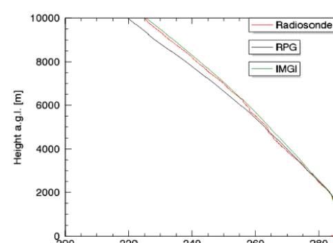
Figure 2. Temperature vertical profile for the lower part of the
tro-posphere. The comparison is between (differently colored lines, see inlet) radiosonde and measurements of the radiometer by the RPG-algorithm with the scanning and zenith mode. Data from 9 Septem-ber 2012 at 01:58 UTC (launch time of the radiosonde). The height is expressed in meters above ground.
(Fig. 2). This is a case with a deep near-surface tempera-ture inversion throughout the first 1000 m above ground. The scanning mode gives a better shape of the temperature profile than the zenith mode. This is in agreement with the fact that the scanning mode yields more information about the lower atmospheric layers. For the upper atmosphere the accuracy of the temperature profiles with the two modes is generally similar (not shown), also in agreement with the findings by Crewell and Löhnert (2007).
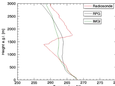
4.2 Evaluation of improved retrieval algorithms As explained in Sect. 2.3, the IMGI algorithm (cf. Table 3) is obtained using more robust statistics by using more and better resolved radiosonde data. Both IMGI and RPG algo-rithms are now applied to the full microwave radiometer data set (September 2012–May 2013). During this time, 84 ra-diosondes were launched and passed quality control. Figure 3 shows the mean RMSE computed between retrieved temper-ature profiles and radiosondes for this data set.
The profiles retrieved by the newly developed IMGI algo-rithm show an overall improvement at all levels with respect to the RPG algorithm. The errors of temperature profiles trieved with the IMGI algorithm (Fig. 3) are considerably re-duced compared to RPG algorithm in nearly all atmospheric layers. The largest improvement can be found in the upper troposphere, but also within the lowest 1000 m the errors are smaller, thus advantageous for studying the boundary layer structure.
Figure 3. Comparison between RPG and IMGI algorithms for
tem-perature profiles within the full troposphere. The RMSE is between temperature retrieved from the two algorithms and radiosonde in function of height (above ground). The 84 days refer to the time pe-riod from September 2012 to May 2013 and are all during the night. The radiosonde measurements are from the airport of Innsbruck and the profiler is located on the roof of IMGI.
it increases to 1.5 K at 4000 m and stays within 3.5 K at 10 000 m. Our results compare well and are even slightly bet-ter than those of previously published studies. One of the most recent and statistically most robust results of temper-ature profiles retrieved by ground-based radiometry is from Löhnert and Maier (2012). They used observations from the same type of radiometer at the aerological station of Payerne at 456 m a.s.l. (MeteoSwiss) and compared their profiles with collocated radiosonde data. They found an RMSE between retrieved profiles and radiosonde data to be between 0.4 and 0.8 K in the lowest 500 m, within 1.2 K at 1200 m and around 1.7 K at 4000 m above ground.
This improved performance is very encouraging given the fact that Löhnert and Maier (2012) used a significantly larger radiosonde data set (of about 12 000 high-resolution radiosondes during both daytime and nighttime) for their re-trieval, providing a more robust diurnal cycle but also more robust statistics in general than we had at our disposal. More-over, and probably more importantly, the obtained perfor-mance being equal (or even slightly better than) to that from less complex terrain demonstrates that microwave radiation originating from nearby slopes (or terrain in general) is not likely to deteriorate the quality of vertical profile informa-tion. Hence, the use of HATPRO for the continuous monitor-ing of the boundary layer (and beyond) in a mountain valley is possible and promising – at least if the scanning mode is performed in along-valley direction as in the present case.
The IMGI algorithm also outperforms RPG algorithm for humidity profiles (Fig. 4). The improvement is ob-served throughout the full troposphere and it is especially pronounced in the lower atmospheric layers. In
particu-Figure 4. Same as Fig. 3, but for absolute humidity.
Figure 5. Temperature profile within the full troposphere. The
com-parison is between (differently colored lines, see inlet) radiosonde, RPG algorithm, IMGI algorithm. They refer to 9 September 2012 at 01:58 UTC (launch time of the radiosonde). The height is expressed in meters above ground.
Figure 6. Temperature vertical profile for the lower part of the
tro-posphere. The comparison is between (differently colored lines, see inlet) radiosonde, RPG algorithm, IMGI algorithm. They refer to 14 September 2013 at 03:18 UTC (launch time of the radiosonde). The height is expressed in meters above ground.
With the knowledge of improved statistical performance, we now evaluate our new IMGI retrieval for a couple of in-version cases. Figure 5 shows the same case of a deep night-time inversion as in Fig. 2, but for the retrieved temperature profiles with the RPG and IMGI algorithms. Both algorithms capture the inversion, but the IMGI reproduces the tempera-ture gradient slightly better; in the middle to high troposphere the better performance of the IMGI algorithm is evident. Fig-ure 6 shows a night with a very strong elevated temperatFig-ure inversion around 1500 m above ground. Both the RPG and the IMGI algorithms reproduce it only roughly. This type of inversion case is nearly impossible to retrieve by radiometers when only ground-based measurements are available. Sim-ilar underperformance has already been shown by Löhnert and Maier (2012) using the same instrument and by Knupp et al. (2009), operating a similar profiling radiometer (manu-factured by Radiometrics Corporation). This is likely due to the height of the inversion, which is higher than the atmo-spheric layers that benefit from the scanning mode (see, e.g., Crewell and Löhnert, 2007); hence the radiometer informa-tion is not sufficient to resolve it. Addiinforma-tionally, a much larger number of cases in the training data set showing an elevated inversion of this type (note that in the current training data set this number is quite limited) might slightly improve the statistics but clearly will not overcome this problem of poor resolution aloft.
An example of a retrieved nighttime humidity profiles is shown in Fig. 7. Only the mean shape of the actual humidity profile is reproduced by both retrievals, but for the present ex-ample the IMGI algorithm yields a slightly better overall ac-curacy. This is related to the transparency of the atmosphere in the K-band and in accordance with the findings by
Lilje-Figure 7. Humidity vertical profile within the full troposphere.
The comparison is between (differently colored lines, see inlet) ra-diosonde, RPG algorithm, IMGI algorithm. They refer to 3 Septem-ber 2012 at 02:02 UTC (launch time of the radiosonde). The height is expressed in meters above ground.
gren et al. (2001) and Ware et al. (2003), using similar pas-sive microwave radiometers. The lower information on the vertical humidity distribution is caused by the lower infor-mation content for water vapor than for temperature observa-tions; for humidity profiles there are 1–2 independent degrees of freedom, whereas for temperature profiles the scanning measurement contains 4 independent pieces of information (Löhnert et al., 2009).
4.3 Impact of targeted training data sets
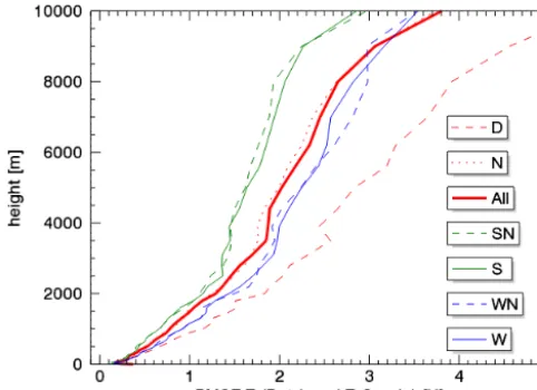
Figure 8. Effect of a specialized training considering time of year
or time of day. RMSE between IMGI retrieved temperature and ra-diosonde in function of height (above the radiometer) for the full troposphere. D: daytime radiosonde (134); N: nighttime (3023); All: overall set of radiosonde (3157); SN: summer nighttime (984); S: summer (1028); WN: winter nighttime (990); W: winter (1026).
The statistics for summer and winter retrievals are quite ro-bust (more than 1000 profiles). However, in winter (or in the cold months) it seems to be more difficult to retrieve the tem-perature profile. The differences between summer and winter can be partly explained by more frequent elevated and multi-ple inversions in winter. Moreover, in mid-tropospheric lev-els, the natural atmospheric variability is lower in summer, resulting in a smaller climatic RMSE.
Concerning the diurnal cycle the daytime boundary layer is often characterized by an elevated inversion (entrainment layer during thermally dominated situations); on the other hand for dynamically dominated situations often no inver-sions are present. Therefore, apparently “daytime” is a crite-rion that is not sufficiently unique to benefit from a special-ized retrieval.
The results show that, with careful selection of climatic subsets, the resulting profile algorithms can yield better re-sults. However, for transition periods between different sea-sons or day/night a combined algorithm would be required in order to continuously monitor atmospheric profiles.
Apparently, summer profiles are overall more similar among themselves than the winter profiles. Likely due to the abundance of nighttime profiles in the present data set, the summer profiles have no or only surface inversions, whereas the group of winter profiles possesses many cases of elevated or even multiple inversions. The fact that there are largely im-proved results for the S and SN specialized retrievals, in prin-ciple, suggests that a better selection of the training profiles can yield better results. However, only if physically mean-ingful specializations are chosen – and if these groups have
Figure 9. Comparison between a retrieval based only on the
bright-ness temperatures (called “no additional regr.”), a retrieval with the temperature at 1600 m (called “1 additional regr.”) and a retrieval with the temperature at several heights (400, 800, 1200, 1600 m) as further regressors (called “4 additional regr.”). The RMSE is be-tween retrieved temperature and radiosonde in function of height (above ground).
a sufficiently large database – the targeted specialized re-trievals can be beneficial.
4.4 Additional regressors
Another potential method for improving the accuracy of the retrieval is including additional regressors into the algorithm development (Eq. 2), like the pressure or temperature at the height of the radiometer. These data have been shown to im-prove the temperature and humidity retrievals in the lower atmosphere (Del Frate and Schiavon, 1998). Alternatively, in mountainous regions, such as the Inn Valley, it is possible to include pressure and temperature measurements from mete-orological stations on the surrounding mountains. One such example is a weather station at Patscherkofel in the vicinity of Innsbruck, at about 1600 m above the valley floor, and at only 8 km horizontal distance from the microwave radiome-ter location. More generally, in such a radiome-terrain the temperature at specific altitudes can be routinely available.
As a proof of concept, we test two new retrievals. The first one uses the temperature at 1600 m above the valley floor as the additional information and the second retrieval uses “a slope profile”, i.e., temperatures at 400, 800, 1200, 1600 m (above the valley floor) as additional regressors.
Figure 10. The effect of additional regressors for a real case that
refers to 14 February 2013 at 03:18 UTC (launch time of the ra-diosonde). The comparison is between the radiosonde profile, a re-trieval based only on the brightness temperatures (called “no addi-tional regr.”, corresponding to the IMGI algorithm) and a retrieval with the temperature at several heights (400, 800, 1200, 1600 m) as further regressors (called “4 additional regr.”). The height is above ground.
about 0.1 K). The beneficial effect of these additional re-gressors is most pronounced within a zone of several hun-dred meters around the height of the additional temperatures themselves. Still, the overall RMSE is improved also up to the mid-troposphere, especially for four additional regres-sors constraining the retrieved profile. Therefore, the disad-vantage of operating the radiometer in mountainous terrain, with frequent higher-level inversions that are challenging for standard radiometer retrievals, can potentially be turned into a benefit; the resolution of the radiometer profile in the lower troposphere might be improved in a mountainous re-gion where additional surface measurements from different altitudes (e.g., along a nearby slope or from mountain peaks) are available.
The potential of such an approach becomes clear when considering an example with a pronounced elevated inver-sion, which both the RPG and IMGI retrievals were unable to resolve properly. Figure 10 shows the same case as Fig. 6 but for the IMGI retrieval and the new retrieval with four additional regressors. The retrieval algorithm with the in-formation from elevated levels included provides a signif-icantly better representation of the inversion than the non-specialized (IMGI) algorithm, both in terms of inversion height and temperature gradient. Naturally, the improvement is largest at levels where the additional information comes from.
The additional regressors used in the present “proof of concept” are the actual temperatures at various heights in the valley atmosphere. The measurements one can possibly have at disposition, however, even in complex mountainous
ter-rain with steep slopes and nearby peaks are surface based observations, e.g. along a slope or on mountain tops of dif-ferent heights. Some decades ago a number of comparisons between slope profiles and free air temperature profiles (even for the Inn Valley) were performed (e.g., Brehm and Freytag 1982; Dreiseitl, 1988). Clearly, a slope observation is influ-enced by nearby terrain and thus a slope profile will not, in general, be equal to that in the valley boundary layer. More recent simulations using meso-scale numerical models and idealized topography (e.g., Wagner et al., 2014) show that isentropes are not horizontal in a valley atmosphere (at least under convective conditions as in their case) due to the lo-cal baroclinicity of the flow. Thus, the slope profile will not detect an elevated inversion at the correct height – but likely at a consistently different height. Numerical simulations us-ing idealized terrain might suffer from over-idealization, i.e., in the present case the (assumed) symmetry with respect to solar insolation on the slopes. Matzinger et al. (2003) have shown that net radiation (essentially providing the energy to heat the slopes) can be up to a factor of 3 different at different positions in a north–south-oriented valley in mid-latitudes under convective conditions and the surface heat fluxes vary correspondingly (Rotach et al., 2008). Turbulent mixing and the resulting cross-valley, thermally driven circulation, how-ever, will have a tendency to alleviate these contrasts. Laiti et al. (2013) have used spatial interpolation techniques to ob-tain cross-valley temperature distributions based on airborne observations (for a small valley in the Italian Alps). Clearly, the isentropes are not horizontal for many of their flights and cross sections but they appear to be “sufficiently uniform” to at least make it plausible that a slope-based profile might add some additional information to improve the retrieval if included in the algorithm.
In this sense, it can be hypothesized that a slope-based pro-file will exhibit the gross features of elevated inversions (such as in Fig. 10) and is likely to considerably improve the overall performance of the retrieval. This approach is currently be-ing tested on the basis of actual slope profiles in the vicinity of our profiler – and results will be detailed in a later con-tribution. It will also be interesting to find out up to which horizontal distance from a profiler location a mountaintop measurement site would have a beneficial impact on the re-trieval algorithm.
4.5 Boundary layer dynamics
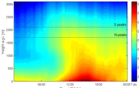
neu-Figure 11. Daily temperature evolution for 14 February 2013
ob-tained from IMGI retrieval (with no additional regressors) in the lower part of atmosphere. The time is expressed in UTC and the height is expressed in meters above ground level (a.g.l.). The dot-ted horizontal lines correspond to the approximate peak heights to-wards the north (N, about 1700 m) and south of the valley (S, about 2100 m).
tral stratification near the ground while the remainder of the valley atmosphere remains stable (∂T /∂z≈ −0.003 km−1) throughout the afternoon. Above the crest height the some-what weaker stratification of the large-scale flow persists throughout the day. Apparently, the flow interaction between the free troposphere and the valley atmosphere is largely con-strained by the surrounding topography under the wintertime conditions of Fig. 11. For more convective conditions, nu-merical simulations using idealized terrain (Wagner et al., 2014) suggest that – depending on the dimensions of the valley – the stability characteristics of the valley atmosphere can be confined to below crest height or extend up to much higher altitudes. The example of Fig. 11 demonstrates both the potential of a microwave temperature profiler to resolve the temporal development much better than a sequence of soundings could – and this is of course not specific for moun-tainous terrain – as well as the necessity to optimally resolve elevated inversions in this type of environment.
5 Conclusions and outlook
Within the i-Box Project a RPG-HATPRO microwave ra-diometer was operated for one of the first times during a pro-longed period in an alpine valley, i.e., in truly complex ter-rain. Although the atmospheric boundary layer is not homo-geneous in this terrain, the radiometer allows obtaining con-tinuous temperature and humidity profiles with acceptable accuracy and shows no deterioration of the retrieved profile due to the influence of microwave radiation from the nearby terrain. These profiles can be used for studying boundary layer processes in complex mountainous terrain. Observa-tions show that by using the elevation scanning mode more
accurate temperature profiles can be retrieved in the lowest 1200 m above ground, as already reported by Crewell and Löhnert (2007). Furthermore, we could show that we were able to improve the retrieval algorithm even further.
First, temperature and humidity profiles retrieved by the algorithm provided by the manufacturer (RPG algorithm) and an improved retrieval (IMGI algorithm), based on more robust statistics, have been compared for simultaneous night-time radiosondes. The more robust statistics consists of a larger radiosonde data set, using their full vertical resolu-tion, finding the best noise level and determining the best regression type (linear or quadratic). Considering 84 nights between September 2012 and May 2013 for which the ra-diometer and radiosonde data are available, the IMGI algo-rithm gives improved results both for temperature and abso-lute humidity. It can be concluded that the set of training data, i.e., the local climatology, is essential for obtaining accurate profiles. Specifically, the accuracy of the retrieved tempera-ture profile with the IMGI retrieval is comparable to those obtained from other radiometers operated in less complex terrain (Löhnert and Maier, 2012; Löhnert et al., 2007) and at certain height ranges even better. It is thus shown that with the availability of a local, long-term, high-resolution train-ing data set a microwave radiometer can be operated even in truly complex terrain.
On the other hand, neither the RPG nor the improved retrieval algorithms are able to accurately capture elevated temperature inversions at the level of the valley crest (typi-cally above 1200 m in the present environment). It is known that these cases pose significant challenges to radiometry (Crewell and Löhnert, 2007). The most promising approach in complex mountainous terrain would be to include addi-tional regressors from mountain stations into the retrieval. Our results show that the accuracy of the retrieved temper-atures improves considerably at heights around those of ad-ditional regressors (despite the fact that the information on the height of those regressors is not included in the retrieval). Also and perhaps more importantly, the retrieval algorithm with these additional regressors is able to resolve an elevated inversion to an unprecedented degree.
net-work, might be tested as well for this purpose. A powerful method of classification of the profiles could be in terms of their atmospheric stability.
Finally, when considering humidity profiles, details within the boundary layer cannot be resolved precisely, due to the limited information content of HATPRO observations. In or-der to obtain a better accuracy of retrieved humidity, it is likely necessary to use additional frequencies (e.g., 183 GHz) where the water vapor absorption is higher or to operate the radiometer in synergy with other remote-sensing instruments (e.g., Raman lidar). Also, humidity observations on slopes or mountaintops could act as additional regressors like we pre-sented for temperature profiles.
Acknowledgements. The authors thank Austro Control of Inns-bruck for providing with the radiosonde data. G. Massaro acknowledges the Erasmus Programme funding and E. Martines (National Research Council, Italy), who allowed him to take part in this research at the University of Innsbruck as part of his degree at the University of Padua. The authors also thank R. Stauffer and J. Messner (IMGI) for the fruitful discussions in statistics.
Edited by: S. J. Munchak
References
Bougeault, P., Binder, P., Buzzi, A., Dirks, R., Kuettner, J., Houze, R., Smith, R.B., Steinacker, R., and Volkert, H.: The MAP Spe-cial Observing Period, Bull. Amer. Meteor. Soc. 82, 433–462, 2001.
Brehm, M. and Freytag, C.: Erosion of the Night-Time Thermal Circulation in an Alpine Valley Arch, Met. Geoph. Biokl., Set. B, 31, 331–352, 1982.
Crewell, S. and Löhnert, U.: Accuracy of boundary layer tempera-ture profiles retrieved with multifrequency multiangle microwave radiometry, IEEE T. Geosci. and Remote, 45, 2195–2201, 2007. Del Frate, F. and Schiavon, G.: A combined natural orthogonal functions/neural network technique for the radiometric estima-tion of atmospheric profiles, Radio Sci., 2, 405–410, 1998. Divakarla, M. G., Barnet, C. D., Goldberg, M. D., McMillin, L. M.,
Maddy, E., Wolf, W., Zhou, L., and Liu, X.: Validation of atmo-spheric infrared sounder temperature and water vapor retrievals with matched radiosonde measurements and forecasts, J. Geoph. Res., 111, D09S15, doi:10.1029/2005JD006116, 2006. Dreiseitl, E.: Slope and Free Air Temperature in the Inn Valley,
Me-teorol. Atmos. Phys., 39, 25–41, 1988.
Güldner, J.: A model-based approach to adjust microwave observa-tions for operational applicaobserva-tions: results of a campaign at Mu-nich Airport in winter 2011/2012, Atmos. Meas. Tech., 6, 2879– 2891, doi:10.5194/amt-6-2879-2013, 2013.
Harnisch, F., Gohm, A., Fix, A., Schnitzhofer, R., Hansel, A., and Neininger, B.: Spatial distribution of aerosols in the Inn Valley atmosphere during wintertime, Meteor. Atmos. Phys., 103, 223– 235, 2009.
Janssen, M. A: Atmospheric Remote Sensing by Microwave Ra-diometry, Wiley, New York, 1993.
Karstens, U., Simmer, C., and Ruprecht, E.: Remote sensing of cloud liquid water, Meteorol. Atmos. Phys., 54, 157–171, 1994. Knupp, K. R. , Ware, R. , Cimini, D. , Vandenberghe, F. ,
Vivekanan-dan, J., Westwater, E. , Coleman, T., and Phillips, D.: Ground-based passive microwave profiling during dynamic weather con-ditions, J. Atmos. Oceanic Technol., 26, 1057–1073, 2009. Laiti, L., Zardi, D., de Franceschi, M., and Rampanelli, G.:
Atmo-spheric boundary layer structures associated with the Ora del Garda wind in the Alps as revealed from airborne and surface measurements, Atmos. Res., 132/133, 473–489, 2013.
Liljegren, J., Lesht, B., Kato, S., and Clothiaux, E.: Initial evalua-tion of profiles of temperature, water vapour and cloud liquid wa-ter from a new microwave profiling radiomewa-ter, 11th American Meteorological Society Symposium on Meteorological Observa-tions and Instruments, Albuquerque, New Mexico, 14–19 Jan-uary 2001, 2001.
Löhnert, U. and Crewell, S.: Accuracy of cloud liquid water path from ground-based microwave radiometry – Part I: de-pendency on cloud model statistics, Radio Sci., 38, 8041, doi:10.1029/2002RS002654, 2003.
Löhnert, U., Turner, D. D., and Crewell, S.: Ground-based tempera-ture and humidity profiles using spectral infrared and microwave observations – Part I: simulated retrieval performance in clear-sky conditions, J. Appl. Meteor. Climatol., 48, 1017–1032, 2009. Löhnert, U. and Maier, O.: Operational profiling of tempera-ture using ground-based microwave radiometry at Payerne: prospects and challenges, Atmos. Meas. Tech., 5, 1121–1134, doi:10.5194/amt-5-1121-2012, 2012.
Matzinger, N., Andreatta, M., van Gorsel, E., Vogt, R., Ohmura, A., and Rotach, M. W.: Surface radiation budget in an Alpine valley, Q. J. R. Meteorol. Soc., 129, 877–895, 2003.
Rose, T., Crewell, S., and Löhnert, U.: A network suitable mi-crowave radiometer for operational monitoring of the cloudy at-mosphere, Atmos. Res., 75, 183–200, 2005.
Rosenkranz, P.: Water vapour continuum absorption: a comparison of measurements and models, Radio Sci., 33, 919–928, 1998. Rotach, M. W. and Zardi, D.: On the boundary-layer structure over
highly complex terrain: key findings from MAP, Q. J. R. Meteo-rol. Soc., 133, 937–948, 2007.
Rotach, M. W., Andretta, M., Calanca, P., Weigel, A. P., and Weiss, A.: Turbulence characteristics and exchange mechanisms in highly complex terrain, Acta Geophys., 56, 194–219, 2008. Rotach, M. W., Stiperski, I., Gohm, A., Sfyri, E., Goger, B.,
Vergeiner, J., and Fuhrer, O.: The Innsbruck-Box (i-Box) – an observational and modeling framework for the investigation of exchange processes over complex topography, Bull. Amer. Me-teorolo. Soc., submitted, 2015.
Sanchez, J. L., Posada, R., Garcia-Ortega, E., Lopez, L., and Mar-cos, J. L.: A method to improve the accuracy of continuous mea-suring of vertical profiles of temperature and water vapor density by means of a ground-based microwave radiometer, Atmos. Res., 122, 43–54, 2013.
Steppeler, J., Doms, G. , Schättler, U., Bitzer, H., Gassmann, A., Damrath, U., and Gregoric, G.: Meso-gamma scale forecast us-ing the non-hydrostatic model LM, Meteor. Atmos. Phys., 82, 75–96, 2003.
Vaisala: Vaisala Radiosonde RS92-SGP data sheet, Vaisala Oyj, Vantaa, Finland, 2013.
Wagner, J. S., Gohm, A., and Rotach, M. W.: The impact of val-ley geometry on daytime thermally driven flows and vertical transport processes, Qart. J. Roy. Meteorol. Soc., 1477-870X, doi:10.1002/qj.2481, 2014.
Ware, R., Carpenter, R., Güldner, J., Liljegren, J., Nehrkorn, T., Sol-heim, F., and Vandenberghe, F.: A multichannel radiometric pro-filer of temperature, humidity and cloud liquid, Radio Sci., 38, 8079–8092, 2003.
Weigel, A. P. and Rotach, M. W.: Flow structure and turbulence characteristics of the daytime atmosphere in a steep and narrow Alpine valley, Quart. J. Roy. Meteorol. Soc., 130, 2605–2627, 2004.
Wolf, T., Isau, I., and Reuder, J.: Analysis of the vertical structure in the Bergen valley, Norway, and its connection to pollution episodes, J. Geophys. Res., 119, 10–645, 2014.
Zardi, D. and Whiteman, C. D.: Diurnal Mountain Wind Sys-tems, Chapter 2, in: Mountain Weather Research and Forecast-ing, edited by: Chow, F. K., DeWekker, S. F. J., and Snyder, B., Springer, Berlin, 35–119, 2012.