ISSN Online: 2327-4344 ISSN Print: 2327-4336
DOI: 10.4236/gep.2018.68003 Aug. 3, 2018 25 Journal of Geoscience and Environment Protection
Spatial and Temporal Characteristics of
Drought and Flood in Quanzhou Based on
Standardized Precipitation Index (SPI) in
Recent 55 Years
Dehe Liu
1, Jingfei You
2, Qijie Xie
2, Yuanyuan Huang
3, Huajun Tong
21Yongchun County Meteorological Bureau of Fujian Province, Yongchun, China 2Quanzhou Meteorological Bureau of Fujian Province, Quanzhou, China 3Nan’an Meteorological Bureau of Fujian Province, Nan’an, China
Abstract
To analyze the characteristics of drought and flood variations in Quanzhou during recent 55 years, the standardized precipitation index (SPI) and Em-pirical Orthogonal Function (EOF) and Rotated EmEm-pirical Orthogonal Func-tion (REOF) were calculated by using the monthly precipitaFunc-tion data from 6 meteorological bureaus across Quanzhou for 1960-2014. Results showed that: 1) During 1960-2014, the drought and flood showed Periodic variation cha-racteristics in Quanzhou, the specific period of frequent drought was 1963-1972, 1977-1986 and 2009-2011, and the specific period of frequent flood was 1961-1962, 1972-1975, 1990-1992 and 1997-2007; the drought and flood did not have significant tendency of variation in Spring and Summer, and the drought and flood showed a non-significant downward trend in Au-tumn and Winter. 2) The drought and flood variation had relatively consis-tent trend in Quanzhou, but there was a big difference on the northwest mountainous area, the middle semi-mountainous area and the southeast coast area in some periods. 3) The precipitation cell and distribution in every season were Nan’an and Anxi, but there was a big difference in rainfall less area: it was Yongchun and Dehua in Spring, Chongwu and Jinjiang in Sum-mer, Chongwu in Autumn, Dehua and Chongwu in Winter.
Keywords
Standardized Precipitation Index, Drought and Flood, Empirical Orthogonal Function (EOF), Rotated Empirical Orthogonal Function (REOF)
How to cite this paper: Liu, D.H., You, J.F., Xie, Q.J., Huang, Y.Y. and Tong, H.J. (2018) Spatial and Temporal Characteris-tics of Drought and Flood in Quanzhou Based on Standardized Precipitation Index (SPI) in Recent 55 Years. Journal of Geos-cience and Environment Protection, 6, 25-37.
https://doi.org/10.4236/gep.2018.68003
Received: July 2, 2018 Accepted: July 31, 2018 Published: August 3, 2018
Copyright © 2018 by authors and Scientific Research Publishing Inc. This work is licensed under the Creative Commons Attribution International License (CC BY 4.0).
DOI: 10.4236/gep.2018.68003 26 Journal of Geoscience and Environment Protection
1. Introduction
The loss caused by meteorological disasters is huge, and in meteorological disas-ters, the effects of droughts and floods are the most serious [1]. Located on the southeastern coast of Fujian Province, Quanzhou is a subtropical marine mon-soon climate. It is located in the middle section of the Jidong Mountains and in the middle of the hilly plain on the southeast coast of Fujian. The west is the main part of Daiyunshan. It is adjacent to the Taiwan Strait in the south, facing the mountains and the sea. The terrain is low in the northwest and high in the southeast, and has the topography and landforms of mountains, hills and coastal plains. The regional climate characteristics are obvious. The intensity of the monsoon and its appearance sooner or later have a greater impact on the preci-pitation time and regional distribution. Drought and flood disasters often occur and it is one of the most severe meteorological disasters in Quanzhou. It has be-come an important factor that restricts socio-economic sustainable development in Quanzhou.
DOI: 10.4236/gep.2018.68003 27 Journal of Geoscience and Environment Protection
2. Data and Methods
2.1. Research Data
The data used by the Institute is the monthly precipitation data from 6 regular weather stations in Quanzhou during 1960-2014. In order to ensure the integrity and continuity of the data, the monthly precipitation data from Anxi Station in January, August, and August in January 1968 and January 1971 were used to in-terpolate the monthly precipitation data from the Nan’an Station with the best correlation.
2.2. Research Methods
The Standardized Precipitation Index (SPI) was proposed by McKee et al. [10]. Only a relatively long period of precipitation (generally more than 30 years) is needed to calculate the drought index at different time scales. It is applicable to drought monitoring and assessment on a monthly scale. The formula is [11] [12]:
(
)
(
3 22)
1 1 01.0 t c t c t c SPI Sd t d t d t
− + +
=
+ + +
(1)
In the formula,
( )
2 1 lnt
g x
= , g x
( )
is the probability distribution ofpre-cipitation associated with the Γ function; x is the sample of precipitation; S is the positive and negative coefficient of probability density.
When g x
( )
>0.5, S = 1; when g x( )
≤0.5, S = −1. g x( )
is calculated from the probability density integral formula of the Γ distribution function:( )
( )
10 0
1 x e d , x 0
g x xα β x x
α
β α
− −
= >
Γ
∫
(2)In the formula,
α
and β are the shape parameters and scale parameters of the Γ distribution function, respectively. c0, c1, c2 and d1, d2, d3 arethe calculation parameters of the simplified approximate solution formula for the conversion of the Γ distribution function to the cumulative frequency, where c0 = 2.515517, c1 = 0.802853, c2 = 0.010328, d1 = 1.432788, d2
= 0.189269, d3 = 0.001308.
DOI: 10.4236/gep.2018.68003 28 Journal of Geoscience and Environment Protection Mckee [10], and the degree of drought was added according to the drought level criteria (Table 1).
The empirical orthogonal function (EOF) and the rotational empirical ortho-gonal function (REOF) can convert the original multiple related indexes to a few new and independent comprehensive indexes without losing or losing the origi-nal information. Therefore, EOF was used to process the SPI sequences of each station, and the overall trend of drought and flood changes over time and the spatial distribution of drought and flood were analyzed. By rotating the EOF feature vector (REOF) and redistributing the variance, the principal components have more separation, and the rotative factor load vector is obtained. Each vec-tor represents the spatial correlation distribution structure. The larger the value is, the better the correlation is, and the closer to 0 is the irrelevance, so that the results of the principal component analysis can be better explained and the area of the drought and flood is divided.
3. Results and Analysis
3.1. Characteristics of Drought and Flood Time Change
3.1.1. SPI Comparison of Different Time Scales [image:4.595.206.540.574.709.2]The multi-time scale characteristics of SPI can realize the monitoring of different types of droughts and floods. Synthetic application of SPI at each time scale can comprehensively monitor and evaluate droughts and floods. Figure 1 shows the evolution of SPI1 (1 month), SPI3 (3 months), SPI6 (6 months), and SPI12 (12 months) in Quanzhou from 1960 to 2014. As can be seen from the figure, since the SPI1 value is greatly affected by the monthly precipitation, it is weak in time duration and frequent changes between months, reflecting the characteristics of the monthly changes of the drought and flood. SPI3 represents short-term water deficits, which are mainly influenced by short-term (3 months) precipitation. SPI3 values fluctuate more frequently on the 0-line, reflecting the short-term change characteristics of drought and flood. As the time scale increases, the re-sponse of SPI6 and SPI12 to short-term precipitation slows, the drought and flood changes are more stable, the cycle is more obvious, and it has a better
Table 1. SPI drought and flood level classification.
SPI Value Range Drought and Flood Level
SPI ≤−2.0 Extremely drought
−2.0 < SPI ≤−1.5 Heavy drought
−1.5< SPI ≤−1.0 Drought
−1.0 < SPI < 1.0 normal
1.5 > SPI ≥ 1.0 Waterlog
2.0 > SPI ≥ 1.5 Heavy Waterlog
DOI: 10.4236/gep.2018.68003 29 Journal of Geoscience and Environment Protection
Figure 1. The evolution of SPI1, SPI3, SPI6 and SPI12 in Quanzhou from 1960 to 2014.
reflection on the underlying soil moisture, river runoff, groundwater level and reservoir water storage capacity. The characteristics of long-term changes in drought and flood can be clearly reflected.
cu-DOI: 10.4236/gep.2018.68003 30 Journal of Geoscience and Environment Protection mulative effects of previous precipitation changes [13].
3.1.2. Inter-Annual Variation Characteristics of Drought and Flood
The interannual change of SPI can reflect the specific time period of drought and flood. As can be seen from the monthly changes in SPI12 in Figure 1, there were 22 droughts and 17 rainstorms in Quanzhou during the period 1960-2014. The specific time periods of frequent drought events occurred in 1963-1972, 1977-1986, and 2009-2011. Among them, extreme drought events occurred twice, that is, in May 1963 and April 1968, the SPIs were all less than −2.0. The specific time periods of frequent rainstorm incidents were 1961-1962, 1972-1975, 1990-1992 and 1997-2007, of which the extreme events occurred seven times. The results of the interannual change analysis of the drought and flood are consistent with the years of severe droughts and floods in the history of Quanzhou [14][15][16]. Calculating the average annual rate of SPI12 in Qua-nzhou is only 0.091/10a, which indicates that the overall drought in QuaQua-nzhou is weak and the precipitation is slightly increased, but the trend is not significant.
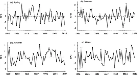
3.1.3. Seasonal Characteristics of Drought and Flood Changes
Related studies have shown that the time scale of 3 months SPI can be used to analyze seasonal drought, and can better represent the agricultural drought con-ditions [17][18]. Therefore, the seasonal SPI index was used to analyze the sea-sonal variation characteristics of drought and flood in Quanzhou (Figure 2). SPI3 values in May, August, November, and February were respectively used to represent the SPI values of spring, summer, autumn, and winter.
Spring: During the period of 1960-2014, droughts and floods in Quanzhou City were characterized by periodical changes, and droughts dominated from 1960 to 1971. There were 4 spring droughts, with an average of once every 3 years. From 1980 to 1990, the rainstorm was dominant, and there were 5 spring floods, occurring about every 2 years. SPI values were relatively stable between 1972-1979 and 1991-2014. The main years of spring drought occurred in 1963-1964, 1968, 1971, 1991, 1995, 2011 and 2014. The spring drought in 1971 was the most serious and the SPI value reached −1.90. In 1973, 1980, 1983-1984, 1990 and 2000, the year of spring floods, especially in the history of the most re-cent year in 1973, the SPI value reached 2.11. Calculating the linear tendency of SPI3 in spring is only 0.005/10a, indicating that from the long-term trend, there is no change in spring drought and flood in Quanzhou.
DOI: 10.4236/gep.2018.68003 31 Journal of Geoscience and Environment Protection
Figure 2. The change of season SPI index in Quanzhou from 1960 to 2014.
long-term change trend showed that there was no change in summer drought and flood in Quanzhou.
Autumn: The autumn drought in Quanzhou in the 1960s and the 1980s was relatively frequent. In the late 1990s and early 21st century, autumn quails fre-quently occurred, with an average of every 1 - 2 years. The main autumn drought years were 1963, 1965, 1967, 1982, 1986, 1993 and 2014. The main au-tumn disaster years were 1961, 1975, 1990, 1999-2000, 2002-2003 and 2005. Au-tumn drought was the most serious in 1986, with an SPI value of −1.66. The most serious locust plague occurred in autumn in 1990, and the SPI value reached 2.17. Calculating the linear trend rate of SPI3 in the autumn was 0.08/10a, indicating that from the long-term trend, the autumn drought in Qua-nzhou showed a weaker trend, but the reduction trend was not obvious.
DOI: 10.4236/gep.2018.68003 32 Journal of Geoscience and Environment Protection
3.2. Drought and Flood Spatial Variation
3.2.1. Interannual Spatial Variation of Drought and Flood
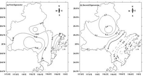
[image:8.595.64.534.452.702.2]The analysis of SPI12 using orthogonal empirical function (EOF) shows that the first two eigenvectors explain 90.9% of the total variance. After the third eigen-vector, the contribution of the variance of each vector is smaller. Therefore, this article only analyzes the first two feature vectors. Figure 3 shows the distribution of the first two eigenvectors. The first feature vector accounts for the largest proportion, accounting for 77.8% of the total variance, and is the main form of spatial distribution of drought and flood in Quanzhou. As can be seen from Figure 3(a), the first feature vector values are all positive. This is obviously due to the influence of large-scale weather systems, and the overall distribution of droughts and floods is a uniform spatial pattern. It is the first type of drought and flood distribution in Quanzhou, namely the overall type. The value of each feature vector is between 0.35 and 0.44. The positive center is located in the Na-nan and Anxi areas in the northwest of Quanzhou. The feature vector values of Jinjiang and Chongwu in the southeast coastal area are small. This shows that the northwestern region has contributed more to the drought and flood in the city than the southeast, is the region with the highest drought and flood variabil-ity, and is a fragile drought and flood area. The second eigenvector explains 13.1% of the total variance. As can be seen from Figure 3(b), the second eigen-vector value is between −0.66 and 0.52, and the northwest and southeast are in the opposite direction. The center is located in Yongchun and Dehua in the northwest, and the negative center is in Chongwu in the southeast. This reflects the trend of drought and flood in the northwest and southeast, which is the
DOI: 10.4236/gep.2018.68003 33 Journal of Geoscience and Environment Protection second type of drought and flood distribution in Quanzhou, namely the north-west-southeast difference type. This is mainly due to the environmental factors such as geographical location and special terrain in Quanzhou, such as the northwest mountainous region is in the windward slope of the Daiyun Moun-tains, and the southeastern part of the coast is in the leeward slope of the Taiwan Mountains.
The first two EOF eigenvectors of SPI12 in Quanzhou were rotated by the maximum variance for factor analysis to further analyze the spatial distribution characteristics of drought and flood in Quanzhou. The absolute value large value region (|feature vector| > 0.8) of the first orthogonal spatial module (REOF) de-composition of the first space module (Figure 4(a)) occupies most of the northwest region of Quanzhou, and the maximum positive value center is in Yongchun. This is somewhat similar to the distribution of the second mode of EOF. The large absolute value region (|feature vector| > 0.8) of the second space model (Figure 4(b)) is located in the southeastern coastal area of Quanzhou, with the largest negative centers in Chongwu and Jinjiang, and also somewhat similar to the distribution of the second mode of EOF. According to the high load area of the first two spatial modes of REOF (load value ≥ 0.6), the drought and flood in Quanzhou is divided into three regions (Figure 4(c)): The coastal areas in the southeast, the mid-level mountains in the middle, and the moun-tains in the northwest, including the southeast coastal areas mainly include Chongwu, Jinjiang, Shishi and most of the islands of Kinmen. The middle part of the mountainous area is mainly south of Nan’an and the northwestern part of the mountain mainly includes Dehua, Yongchun, Anxi, and northern Nan’an. This divisional result is basically consistent with the topographical features of Quanzhou City. The analysis of the linear trend rate of average SPI12 in the three regions shows that the increase trend is not obvious in the middle moun-tainous regions and the northwestern mounmoun-tainous regions, with the central climate tendency rate being 0.054/10a and the north being 0.073/10a. The sou-theastern coastal areas show an increasing trend, with a climatic bias of 0.137/10a (a significant test at the 0.1 level). This shows that there is no obvious trend of droughts and floods in the mountainous areas in the Mid-levels and Northwest of Quanzhou, and the drought conditions in the southeast coastal areas have been reduced.
Whether it is EOF or REOF, Yongchun is always the center point. The overall distribution of EOF and REOF is consistent.
3.2.2. The Characteristics of Spatial Variability in Drought and Flood Seasons
DOI: 10.4236/gep.2018.68003 34 Journal of Geoscience and Environment Protection
Figure 4. The first two spatial models of the annual SPI12 sequence of the REOF in Quanzhou from 1960 to 2014.
DOI: 10.4236/gep.2018.68003 35 Journal of Geoscience and Environment Protection
Figure 5. Distribution of EOF first feature vector field at different seasons in Quanzhou from 1960 to 2014((a) Spring; (b) Sum-mer; (c) Autumn; (d) Winter).
4. Conclusions
1) Droughts and floods in Quanzhou are characterized by periodical changes. There were 22 droughts and 17 rainstorms in Quanzhou during the period from 1960 to 2014. The specific time periods for frequent drought events were 1963-1972, 1977-1986, and 2009-2011. The specific time periods of frequent rainstorm events were 1961-1962, 1972-1975, 1990-1992 and 1997-2007. The drought in Quanzhou generally showed a weaker trend, and precipitation in-creased slightly, but the trend was not significant.
DOI: 10.4236/gep.2018.68003 36 Journal of Geoscience and Environment Protection floods in spring and summer in Quanzhou, but the drought in autumn and win-ter was decreasing, but the trend was not obvious. The spring drought occurred frequently between 1960 and 1971, and the spring flood was concentrated in 1980-1990. Summer droughts and floods were frequent between 1963-1973 and 1988-2008. The autumn drought was more common in the 1960s and 1980s, and the autumn monk occurred frequently in the late 1990s and early 2000s. Winter droughts and floods changed frequently between 1960 and 2014. Winter droughts occurred at the beginning of the 1980s and winters occurred frequently at the beginning of the 21st century.
3) The drought and flood changes in Quanzhou have a relatively uniform trend, but they also show some differences in certain periods, which are mainly represented by the large differences in the northern mountainous area, the mid-dle semi-mountainous area, and the southeastern coastal area. There is no ob-vious trend of droughts and floods in the mountainous areas in the middle and the northwest, but the drought conditions in the southeastern coastal areas have eased.
4) The precipitation in each season in Quanzhou has a good spatial consis-tency. The precipitation centers are in the Nanan and Anxi areas, and there are significant differences in the areas with less rainfall: spring in Yongchun and Dehua; summer in Chongwu and Jinjiang; autumn in Chongwu; winter in De-hua and Chongwu.
Conflicts of Interest
The authors declare no conflicts of interest regarding the publication of this pa-per.
References
[1] Koudahe, K., Kayode, A., Samson, A., Adebola, A. and Djaman, K. (2017) Trend Analysis in Standardized Precipitation Index and Standardized Anomaly Index in the Context of Climate Change in Southern Togo. Atmospheric and Climate Sciences, 7, 401-423. https://doi.org/10.4236/acs.2017.74030
[2] Moorhead, J., Marek, G., Gowda, P., Marek, T., Porter, D., Singh, V. and Brauer, D. (2017) Exceedance Probability of the Standardized Precipitation-Evapotranspiration Index in the Texas High Plains. Agricultural Sciences, 8, 783-800.
https://doi.org/10.4236/as.2017.88058
[3] Zhang, Q., Ju, X.S. and Li, S.H. (1998) Comparison of Three Drought Indicators and Determination of New Indicators. Meteorological Technology, 2, 48-52. [4] Sims, A.P., Niyogi, D.S. and Raman, S. (2002) A Dopting Drought Indices for
Esti-mating Soil Moisture: A North Carolina Case Study. Geophysical Research Letters, 29, 1183-1186. https://doi.org/10.1029/2001GL013343
[5] Quiring, S.M. and Papakryiakou, T.N. (2003) An Evaluation of Agricultural Drought Indices for the Canadian Prairies. Agricultural and Forest Meteorology, 118, 49-62. https://doi.org/10.1016/S0168-1923(03)00072-8
DOI: 10.4236/gep.2018.68003 37 Journal of Geoscience and Environment Protection
Drought in Greece Using the Standardized Precipitation Index (SPI). Theoretical and Applied Climatology, 89, 143-153. https://doi.org/10.1007/s00704-005-0227-z
[7] Wu, H., Hayes, M.J., Wilhite, D.A., et al. (2005) The Effect of the Length of Record on the Standardized Precipitation Index Calculation. International Journal of Cli-matology, 25, 505-520. https://doi.org/10.1002/joc.1142
[8] Wu, H., Svoboda, M.D., Hayes, M.J., et al. (2007) Appropriate Application of the Standardized Precipitation Index in Arid Locations and Dry Season. International Journal of Climatology, 27, 65-79. https://doi.org/10.1002/joc.1371
[9] Yuan, W.P. and Zhou, G.S. (2004) Comparative Analysis of the Application of Standardized Precipitation Index and Z Index in China. Journal of Plant Ecology, 28, 523-529. https://doi.org/10.17521/cjpe.2004.0071
[10] McKee, T.B., Doesken, N.J. and Kleist, J. (1993) The Relation of Drought Frequency and Duration to Time Scales. Proceedings of the 8th Conference on Applied Cli-matology, Anaheim, California, 17-22 January 1993, 179-184.
[11] Omonijo, T. and Okogbue, E. (2014) Trend Analysis of Drought in the Guinea and Sudano-Sahelian Climatic Zones of Northern Nigeria (1907-2006). Atmospheric and Climate Sciences, 4, 483-507. https://doi.org/10.4236/acs.2014.44045
[12] Zhou, Y., Li, N. and Ji, Z.H. (2013) Spatial and Temporal Distribution of Drought in Inner Mongolia during 1981-2010 Based on SPI Index. Journal of Natural Re-sources, 28, 1694-1706.
[13] Che, S.J., Li, C.Q. and Shen, S.H. (2010) Spatio-Temporal Characteristics of Drought and Flood in Hebei Province in the Past 41 Years (1965-2005) Based on SPI. China Agricultural Meteorology, 31, 137-143.
[14] Song, D.Z. and Cai, S.S. (2007) China Meteorological Disasters (Fujian Vol.). Weather Press, Beijing, 392 P.
[15] Lu, S.J. and Wang, Y. (2012) Fujian Climate. Weather Press, Beijing, 520 P. [16] Che, S.J. and Li, C.Q. (2010) Shijiazhuang’s Drought Spatial and Temporal
Distri-bution Based on Standardized Precipitation Index. Meteorological Technology, 38, 66-70.
[17] Patel, N.R., Chopra, P. and Dadhwal, V.K. (2007) Analyzing Spatial Patterns of Me-teorological Drought Using Standardized Precipitation Index. Meteorological Ap-plications, 14, 329-336. https://doi.org/10.1002/met.33