368
THE NATURAL GENESIS CONDITIONS OF SOIL AND ITS TYPES FROM
THE SOUTH WESTERN PART OF DOLJ DISTRICT, PISCU VECHI AND
GHIDICI ZONE
Popescu Cristian, Bălan Mihaela
Keywords: soil, relief, underground water, bedrock, vegetation, litology.
ABSTRACT
Within the South-Western part of Dolj District, the territory of PiscuVechi and Ghidici zone stretches over 5.000 ha.
The main relief forms of this zone are the Danube Lowland, the low and inferior terrace of the river. Hydrographically, the territory of PiscuVechi and Ghidici communes belong to Danube basin yet lithologically, in the Danube lowland the parental material is composed of alluvial deposits with different textures from sandy to clayey; on the inferior terrace the parental material is represented by loess deposits and within low terrace the surface deposits are represented by loess and sandy deposits.
Regarding the vegetation, the territory of Piscuvechi and Ghidici communes it belongs to steppe and sylvosteppe zone. The territory of these two communes has a mosaic of soil types because of diverse natural conditions of formation, even though the surface is not very large. The soil types and the subtypes of soils which were identified on larger or smaller scales belong to the following classes: protisoils, with soil units represented by sandy soils and alluvial soils; chernisoils with different types of chenozem; cambisoils, with a single soil type represented by sandy soil and hydrisoil withmoliccalcaric and salsodicgliosoil as representative types.
On the researched territory there were identified a high number of soil units yet a distribution that emphasizes the complex character of area regarding the formation conditions of soils.
Within the researched area the representative soils are chernozems and less avolved soils as sandy soils and alluvial soils.
INTRODUCTION
The soil is a complex biological system that comprises endless life processes and transformations. By mineral composition and processes that characterizes it, as a result of accumulated transformations and possessing the fundamental feature called fertility, the soil has the capacity to produce vegetal yields.
The knowing of soil and clime conditions and soil features from each zone of the country is very important, the sense of its evolution and the optimal way we should intervene on it in the process of vegetal production for maximizing the use of nutrients in order to reclaim it and continuous amelioration.
Beginning from these issues there was studied the natural conditions of formation of soils from South-Western part of Dolj District, the zone of PiscuVechi and Ghidici communes.
MATERIAL ANDMETHOD
The soil research has been done on field and in laboratory according with the recommended methods of National Institute for Pedology, Agrochemistry and Environment Protection from Bucharest.
369
neoformations, the inclusions) and there were taken soil samples for each horizon beginning with the shallow one.
The soil samples have been analyzed in the Laboratory of Pedology from DistrictualPedological Bureau of Dolj District where there were determined the physical, chemical and water features of soils that were identified within the researched area.
On the basis of Methodology of elaboration of pedological studies from 1987 and the Romanian System of Soil Taxonomy from 2012 the data from soil profiles located on the field and laboratory analyzes there were established the soil types, the soil subtypes and soil varieties.
RESULTS
The territory of Piscu Vechi and Ghidici communes is located in the South-Western extremity of Dolj District. The total surface of Piscu Vechi commune is 2.562 ha and of Ghidici commune, of 4.448 ha.
Within the PiscuVechi and Ghidici communes there are identified, as geomorphological units, the Danube Lowland, the low terrace and the inferior terrace of the river ( figure 1 ).
370
The Danube Lowland is located on the southern part of the territory as a strip along the river, with width of maximum 3 km. the microrelief of the lowland is represented by depressions, higher zones and meanders. Regarding the depressions there are encountered ponds that are linked with the river, permanent ponds that are important for water regime of the river (Tutova pond, Coica pond). However, here are encountered pond bottoms where the ponds were dried and reclaimed for cropping (Tinosul pond
Higher zones within the lowland are represented by sandy dunes, some are stable, others can be drifted (the wind drift the sand). Within the lowland there are encountered large areas with acacia woods, strips of woods against wind drift of sand.
The low terrace occupies the largest part of the territory of these two communes. Geomorphologically, it is called in the specialty literature Ciuperceni terrace or I st terrace of Danube. The characteristic aspect of the terrace is the presence of sand dunes, the dune relief established on the attic of the terrace makes the following of the terrace harder and the sand coverture falsifies its altitude. As a whole, the zone appears as an irregular area having dunes of sand and low surfaces and relatively plane surfaces (interdunes).
The dunes are oriented on WNW-ESE direction reaching altitudes of 500-600m. Their height is variable; the level difference between the crest of the dunes and the bottom of them is 5-6 m at higher dunes and 2-3 m at lower and muddle dunes. The interdunes have the aspect of stretched surfaces, with maximal widths of 500-600 m and they are occupied by soil of chernozem type influenced by water table.
The inferior terrace or the II nd terrace is present on the northern part of the territory and it has an almost plane aspect having the appearance of a slightly undulated plane. Within this area there are distinguished some depressions occupied by ponds or by hydrical soils. The average relative altitude of the deposits of inferior terrace is approximately 12-16 m.
From clime data there results that the average annual temperature is 12.20C which
is one of the warmest zone of the country.
Hydrographically, the territory of PiscuVechi and Ghidicicommunes belongs to the water basin of Danube River. Regarding the water table (figure 2). The cartogram of water table), within these three relief levels there are not high differences because they appear within the same relief form in function of the terrain altitude. On terraces on higher zones (dunes) the water table is at 3-8 m depth and the sandy soils are not influenced by it. Within plane surfaces of the terraces the water table level is between 1.5-3.0 m representing the predominant depth within terraces. In these conditions the soils are influenced by water table becoming wet, intervening in the soil formation process. In depressions of terraces the water table is at 0.5-1.0 m and here the soil are strongly influenced by water table.
As regard the modifications within territory during the last 20 years they unfolded by lifting the underground water by 1-3 m, excepting 2007 year when it lowered due to drought.
The degradation process because of shallow water table began in 1960-1970 when within the II nd terrace the underground water appeared in slight depressions and there appeared ponds where before there were excellent arable soils.
371
and sandy deposits, they constitute the parental material of soil formation for chernozem and sandy soils.
Within the inferior terrace the parental material is constituted by only loess deposits. Within the Danube Lowland the parental material is represented by alluvial deposits with different textures from sandy to clayey. The texture varies here both horizontally and vertically. As regard the thickness of the lowland deposits, after drilling in Pisculet village area there was established that it is of 12 m.
As vegetation, the territory of Piscu Vechi and Ghidici area belongs to steppe and sylvosteppe zones. Regarding the woody vegetation of Danube Lowland there is a characteristic vegetation constituted by light wood species (small forest), where the dominant species are Populustremula and Salix fragilis.
372
The fauna has an important role within the soil formation and evolution processes. The natural complex of researched area is characterized by various physical, geographical and biological conditions that have a high role in the soil formation. Numerous presence of earthworms has determined the presence of their feces and the presence of rodents has conducted to the formation of gallerie.
The soil coverture from PiscuVechi and Ghidici area is presented as a mosaic of soils due to the action of a high number of natural factors on a relatively small area.
Among the soil formation factors that influenced the formation of a high number of soil there are: macrorelief, mezorelief, microrelief, clime, herbaceous and woody vegetation, fauna, parental material, underground water at low depth.
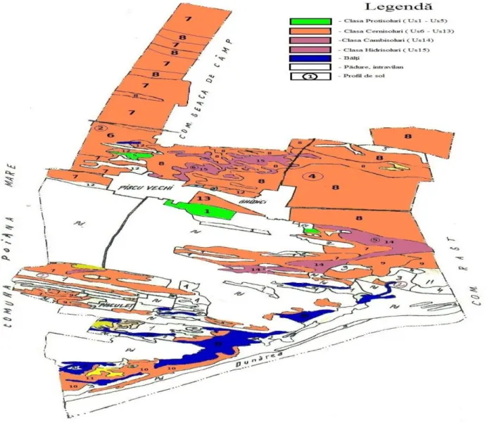
Figure 3. The cartogram of soil classes and units from Piscu Vechi and Ghidici communes.
Under the action of a multitude of soil formation factors that have acted with different intensities during time on the studied territory, by field researches that were made by us there were identified a multitude of soil types, subtypes and varieties that are scattered on small or large areas. Taking account on the high diversity of soils from the researched area, they were grouped as follows (figure 3, the cartogram of soil units).
1. The protisoils class: US 1 – eutric sandy soil, US – 2 – mollic sandy soil, US 3 – molliccalcaricgleycaluviosoil, US 5 – salsodicgleyccalcaricaluviosoil.
2. Chernisoils class: US 6 – cambicchernozem, US 7 – calcaricchernozem, US 8 –
373
gleycaluvicchernozem, US 11 – gleycaluvicsaliniccalcaricchernozem, US 12 –
glaycsalsodicchernozem, US 13 – gleyccalcaricsalinicchernozem. 3. Cambisoils class: US 14 – eutricambosoil sandy soil. 4. Hydrical soils: US 15 – mollicgleyccalcaricsalsodic soil.
From these data there can be said that there were identified a high number of soils as well as a high distribution that shows the complex character of this area as regard the soil formation conditions. On the territory that has been taken in study there can be observed that the dominant soils are chernozems and less evolved soil: sandy soils and alluvial soils. The criteria taken in account for identification and establishing the soil units and their features are the main differentiation indicators under the aspect of their usage for cropping and amelioration of soil properties.
CONCLUSIONS
The zone of Piscu Vechi and Ghidici communes is characterized by a temperate climate with mild winters and warm summers, rainfall in all seasons but unevenly
distributed during the year. The average annual temperature is 12.20C and the rainfall are
583 mm per year.
Within PiscuVechi and Ghidici communes there are identified, as geomorphological units, the Danube Lowland, the low terrace and the inferior terrace of the river.
Due to diverse soil formation conditions, especially the relief, on this territory there were formed and evolved the following soil units:
1. The protisoil class: eutric sandy soils; mollic sandy soils; calcaricgleyc alluvial soils; molliccalcaricgleyc alluvial soils; calcaricgleycsalsodic alluvial soils.
2. The chernisoil class: typical chernozem; cambicchernozem (photograph 3) salsodiccalcaricchernozem; gleyc alluvial chernozem; saliniccalcaric alluvial chernozem; salsodicgleycchernozem; gleyccalcaricsalinicchernozem.
3. Cambisoil class: eutricambosoil sandy soil. 4. Hydrical soils: molliccalcaricsalsodicgleyc soil.
BIBLIOGRAPHY
1. Constantinescu Emilia, Research on the effect of fertilizers on plants grown on
ash dumps as regards their reintegration within agricultural sector. PhD thesis, University of Craiova 1998.
2. Coteţ P., 1957. Câmpia Olteniei – Studii geomorfologice. Editura Ştiinţifică,
Bucureşti.
3. Florea N., Munteanu I., 2012. Sistemul Român de Taxonomie a Solurilor. EdituraSitech, Craiova.
4. Osiceanu M., Ionescu,I.,2005, Cercetări privind periodicitatea îngraşămintelor
cu fosfor şi potasiu pe pajiştile temporare din zona de deal. În Lucr.st.vol.48 USAMV Iasi.
5. Popescu C., 2008. Ecopedologie.Editura Universitaria, Craiova.
6. Vasile C., 2015, The analytical and experimental modeling of functioning of
automated installation from CFF. Annals of University of Craiova-Agriculture, Montanology, Cadastre series, vol. XLV, no. 2, pgs. 241 -246.