International Journal of Research in Engineering & Applied Sciences Email:- [email protected], http://www.euroasiapub.org
An open access scholarly, online, peer-reviewed, interdisciplinary, monthly, and fully refereed journals
70
A study of determination of normal height using interpolation method in the narrow areaNgoc Quang Vu,
Surveying Department, Engineering faculty, University of Transport Technology, Hanoi, Vietnam #54, Trieu Khuc Street, Thanh Xuan district, Hanoi, Vietnam
Abstract
Geometrical leveling is the conventional method to establish leveling control networks in Vietnam. Application of GPS technology for establishing horizontal control networks has been approved since 2000. However, all levels of leveling control networks are not allowed to use GPS technology to determine normal height. This is a huge waste. Paper mentions about a interpolation method using bilinear function combine with GPS technology to determine normal height of technical leveling control network. At the same time, the results are compared with the normal heights determined from conventional leveling method. Paper pointed out the trustworthy results when determining normal height by using interpolation method in the narrow area, and this method helps surveyors to save time and reduce the cost of establishing control network of height. The data and results of this study base on an actual data of a project which has been done in Quangninh province.
Keywords: normal height, bilinear, interpolation, geoid undulation, GPS/leveling.
1. INTRODUCTION
International Journal of Research in Engineering & Applied Sciences Email:- [email protected], http://www.euroasiapub.org
An open access scholarly, online, peer-reviewed, interdisciplinary, monthly, and fully refereed journals
71
purposes.In Vietnam, GPS technology has been applied for many years, but applications largely use for establishing horizontal control networks. All classes of leveling network on the entire of Vietnam are established by the geometrical method. This method is highly accurate but very expensive in terms of time and cost. Surveyors have to use both GPS technology to determine ground coordinates and leveling to determine normal height in the same network and cost and time can be doubled. The Earth gravitational models are not appropriate for all areas. Therefore, GPS technology is not allowed to use to determine normal height till today. Paper does not mention about complex interpolation methods or measures to improve the accuracy when apply GPS technology. Paper uses a simple interpolation method to determine normal height in a short time; moreover, this method saves time and reduces the cost considerably. The results of this study base on an actual project and normal heights from interpolation method were compared with normal heights from leveling method.
2. MATERIAL AND METHODS
To determine the normal height of one point by GPS technology, the geoid undulation at that point need to be knew. To determine the geoid undulation, there are different methods such as using GPS/ leveling method, gravitational method, adjusting terrain. In this research, GPS/leveling method will be use. Therefore, with a point (control point) that simultaneously have ellipsoidal height (H) and normal height (h), the geoid undulation of this point can be determine by equation.
i i
i
H
h
(1)Using horizontal coordinates (X, Y), undulation can be showed by bilinear function as below.
i i
i
c
a
.
X
b
.
Y
(2)To determine three parameters, the minimum number of control points is three points. If this number is more than three points, the parameters will be calculated as the adjustment.
i i i
i
c
a
X
b
Y
v
.
.
(3)International Journal of Research in Engineering & Applied Sciences Email:- [email protected], http://www.euroasiapub.org
An open access scholarly, online, peer-reviewed, interdisciplinary, monthly, and fully refereed journals
72
The length of this route is about 22Km. The entire results of leveling network followed a nationalstandard (Ministry of natural resources and environment, 2008).
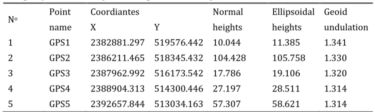
Table 1: Coordinates, normal heights in national coordinate and height systems and ellipsoidal heights of five GPS points
No Point
name
Coordiantes Normal
heights
Ellipsoidal heights
Geoid undulation
X Y
1 GPS1 2382881.297 519576.442 10.044 11.385 1.341 2 GPS2 2386211.465 518345.432 104.428 105.758 1.330 3 GPS3 2387962.992 516173.542 17.786 19.106 1.320 4 GPS4 2388904.313 514300.446 27.197 28.511 1.314 5 GPS5 2392657.844 513034.163 57.307 58.621 1.314
In the interpolation method, the geoid undulation of five GPS points will be determined from ellipsoidal and normal heights as above equations. The geoid undulation of five GPS points that are showed in table 2 will be used to interpolate the geoid undulation of 85 traverse points which have coordinates below.
Table 2: Coordinates of 85 GPS traverse points
No Point name X Y
1 DC01 2383112.993 519651.978
2 DC02 2383257.420 519652.011
3 DC03 2383394.338 519640.782
4 DC04 2383538.161 519568.542
5 DC05 2383681.230 519492.434
6 DC06 2383857.081 519479.476
7 DC07 2383974.347 519375.377
8 DC08 2384110.242 519308.727
9 DC09 2384262.654 519254.052
10 DC10 2384334.534 519117.746
11 DC11 2384447.422 519025.623
12 DC12 2384566.423 518868.795
13 DC13 2384565.733 518685.492
14 DC14 2384747.568 518582.713
15 DC15 2384929.651 518493.306
16 DC16 2385114.859 518442.833
International Journal of Research in Engineering & Applied Sciences Email:- [email protected], http://www.euroasiapub.org
An open access scholarly, online, peer-reviewed, interdisciplinary, monthly, and fully refereed journals
73
18 DC18 2385466.375 518238.298
19 DC19 2385679.193 518284.170
20 DC20 2385838.800 518435.179
21 DC21 2386016.885 518425.977
22 DC22 2386369.317 518168.369
23 DC23 2386579.975 518081.236
24 DC24 2386764.549 517964.819
25 DC25 2386735.561 518199.041
26 DC26 2386976.388 518145.118
27 DC27 2387044.346 517957.136
28 DC28 2387174.663 517791.845
29 DC29 2387224.503 517583.351
30 DC30 2387435.625 517522.904
31 DC31 2387643.316 517541.260
32 DC32 2387651.749 517328.892
33 DC33 2387604.036 517124.313
34 DC34 2387548.203 516919.846
35 DC35 2387739.205 516839.954
36 DC36 2387925.187 516752.249
37 DC37 2388047.994 516571.201
38 DC38 2387920.514 516387.611
39 DC39 2388037.165 516004.526
40 DC40 2388168.280 515949.105
41 DC41 2388272.531 515802.603
42 DC42 2388112.065 515744.186
43 DC43 2387955.747 515700.403
44 DC44 2387844.356 515581.712
45 DC45 2387879.067 515409.236
46 DC46 2387863.327 515257.328
47 DC47 2387935.514 515120.917
48 DC48 2388088.911 515021.574
49 DC49 2388150.740 514866.374
50 DC50 2388174.794 514683.032
51 DC51 2388242.384 514531.163
52 DC52 2388325.907 514399.710
International Journal of Research in Engineering & Applied Sciences Email:- [email protected], http://www.euroasiapub.org
An open access scholarly, online, peer-reviewed, interdisciplinary, monthly, and fully refereed journals
74
54 DC54 2388604.520 514225.663
55 DC55 2388770.726 514198.973
56 DC56 2389062.157 514295.493
57 DC57 2389189.148 514200.570
58 DC58 2389331.906 514142.667
59 DC59 2389442.122 514008.690
60 DC60 2389501.860 513870.265
61 DC61 2389569.551 513745.706
62 DC62 2389700.928 513662.678
63 DC63 2389805.425 513556.307
64 DC64 2389895.339 513421.317
65 DC65 2390066.007 513456.891
66 DC66 2390238.854 513459.954
67 DC67 2390386.133 513492.137
68 DC68 2390534.154 513450.718
69 DC69 2390689.901 513393.597
70 DC70 2390837.896 513371.400
71 DC71 2390978.386 513318.535
72 DC72 2391089.483 513201.123
73 DC73 2391218.208 513129.653
74 DC74 2391322.402 513031.786
75 DC75 2391456.955 512996.343
76 DC76 2391587.562 512945.898
77 DC77 2391721.134 512970.587
78 DC78 2391838.904 513035.528
79 DC79 2391940.934 513116.161
80 DC80 2392053.653 513175.591
81 DC81 2392156.507 513248.066
82 DC82 2392279.231 513316.723
83 DC83 2392382.739 513229.436
84 DC84 2392514.673 513242.738
85 DC85 2392587.078 513134.799
International Journal of Research in Engineering & Applied Sciences Email:- [email protected], http://www.euroasiapub.org
An open access scholarly, online, peer-reviewed, interdisciplinary, monthly, and fully refereed journals
75
interpolation and leveling method are presented in table 4.Table 3: parameters C, a, b
C a b
-0.647411830 -0.000000047 0.000004033
Table 4: Deviation of normal heights of 85 points between interpolation and leveling method Point
name
Ellipsoidal
heights Undulation
Normal heights from interpolation
Normal heights from leveling
Deviation (m)
DC01 11.264 1.338 9.926 9.856 0.070
DC02 11.389 1.338 10.051 9.974 0.077
DC03 11.332 1.338 9.994 9.915 0.079
DC04 12.398 1.337 11.061 10.983 0.078
DC05 11.411 1.337 10.074 9.998 0.076
DC06 14.522 1.337 13.185 13.111 0.074
DC07 21.162 1.336 19.826 19.757 0.069
DC08 22.063 1.336 20.727 20.652 0.075
DC09 28.681 1.336 27.345 27.261 0.084
DC10 20.766 1.335 19.431 19.350 0.081
DC11 19.028 1.335 17.693 17.613 0.080
DC12 37.902 1.334 36.568 36.480 0.088
DC13 49.655 1.334 48.321 48.232 0.089
DC14 48.732 1.333 47.399 47.302 0.097
DC15 43.996 1.333 42.663 42.569 0.094
DC16 45.853 1.333 44.520 44.435 0.085
DC17 52.762 1.332 51.430 51.336 0.094
DC18 45.818 1.332 44.486 44.391 0.095
DC19 58.478 1.332 57.146 57.050 0.096
DC20 78.449 1.333 77.116 77.012 0.104
DC21 96.163 1.333 94.830 94.727 0.103
DC22 112.274 1.331 110.943 110.902 0.041
DC23 110.709 1.331 109.378 109.346 0.032
DC24 95.488 1.331 94.157 94.095 0.062
DC25 72.016 1.332 70.684 70.634 0.050
DC26 40.065 1.331 38.734 38.676 0.058
International Journal of Research in Engineering & Applied Sciences Email:- [email protected], http://www.euroasiapub.org
An open access scholarly, online, peer-reviewed, interdisciplinary, monthly, and fully refereed journals
76
DC28 11.330 1.330 10.000 9.938 0.062
DC29 26.128 1.329 24.799 24.749 0.050
DC30 43.669 1.329 42.340 42.271 0.069
DC31 42.113 1.329 40.784 40.734 0.050
DC32 24.618 1.328 23.290 23.233 0.057
DC33 22.078 1.327 20.751 20.706 0.045
DC34 21.612 1.326 20.286 20.240 0.046
DC35 16.958 1.326 15.632 15.567 0.065
DC36 22.095 1.326 20.769 20.699 0.070
DC37 29.004 1.325 27.679 27.614 0.065
DC38 19.390 1.324 18.066 18.013 0.053
DC39 18.791 1.323 17.468 17.430 0.038
DC40 22.094 1.322 20.772 20.718 0.054
DC41 33.172 1.322 31.850 31.836 0.014
DC42 35.684 1.322 34.362 34.340 0.022
DC43 32.040 1.321 30.719 30.703 0.016
DC44 34.477 1.321 33.156 33.151 0.005
DC45 20.516 1.320 19.196 19.186 0.010
DC46 18.136 1.320 16.816 16.784 0.032
DC47 18.375 1.319 17.056 17.028 0.028
DC48 18.894 1.319 17.575 17.565 0.010
DC49 24.220 1.318 22.902 22.928 -0.026
DC50 24.883 1.317 23.566 23.584 -0.018
DC51 31.056 1.317 29.739 29.766 -0.027
DC52 23.309 1.316 21.993 22.013 -0.020
DC53 21.622 1.316 20.306 20.316 -0.010
DC54 21.054 1.315 19.739 19.748 -0.009
DC55 21.790 1.315 20.475 20.498 -0.023
DC56 32.342 1.316 31.026 31.027 -0.001
DC57 28.582 1.315 27.267 27.259 0.008
DC58 21.864 1.315 20.549 20.540 0.009
DC59 20.893 1.315 19.578 19.592 -0.014
DC60 22.396 1.314 21.082 21.105 -0.023
DC61 26.360 1.313 25.047 25.053 -0.006
DC62 30.252 1.313 28.939 28.977 -0.038
International Journal of Research in Engineering & Applied Sciences Email:- [email protected], http://www.euroasiapub.org
An open access scholarly, online, peer-reviewed, interdisciplinary, monthly, and fully refereed journals
77
DC64 40.760 1.312 39.448 39.498 -0.050
DC65 46.474 1.312 45.162 45.208 -0.046
DC66 22.343 1.312 21.031 21.066 -0.035
DC67 26.311 1.312 24.999 25.029 -0.030
DC68 35.827 1.312 34.515 34.549 -0.034
DC69 43.611 1.312 42.299 42.308 -0.009
DC70 36.244 1.312 34.932 34.960 -0.028
DC71 55.243 1.312 53.931 53.973 -0.042
DC72 49.638 1.311 48.327 48.380 -0.053
DC73 35.704 1.311 34.393 34.424 -0.031
DC74 38.157 1.311 36.846 36.867 -0.021
DC75 39.006 1.310 37.696 37.724 -0.028
DC76 28.481 1.310 27.171 27.203 -0.032
DC77 26.611 1.310 25.301 25.331 -0.030
DC78 25.569 1.310 24.259 24.285 -0.026
DC79 25.612 1.311 24.301 24.323 -0.022
DC80 28.830 1.311 27.519 27.541 -0.022
DC81 27.264 1.311 25.953 25.970 -0.017
DC82 23.940 1.312 22.628 22.639 -0.011
DC83 31.319 1.311 30.008 30.024 -0.016
DC84 49.590 1.311 48.279 48.287 -0.008
DC85 57.032 1.311 55.721 55.726 -0.005
3. RESULTS AND DISCUSSION
The results from table 4 showed that the maximum deviation between two methods is about 0.104. It should be noted that these leveling networks are the pre-feasibility study stage, so this accuracy is completely adopted the requirement of this project.
Using interpolation in this stage of project helps surveyors to save money and time because they can simultaneously determine horizontal coordinates and normal heights of traverse points. Interpolation method is extremely effective in mountainous where leveling method is very difficult to use to determine normal heights of leveling networks.
There are some problems that need to be further studied such as influence of accuracy, density of control points, distribution of them and the accuracy of both horizontal and leveling control points. These aspects will be mentioned in the next study.
International Journal of Research in Engineering & Applied Sciences Email:- [email protected], http://www.euroasiapub.org
An open access scholarly, online, peer-reviewed, interdisciplinary, monthly, and fully refereed journals
78
4. ACKNOWLEDGEMENTAuthor is grateful to Mr Vu Tuan who took main responsibility to perform this project for inviting author participating in work. At the same time, providing data and allowed author to use data in this study.
5. REFERENCE
Adam Łyszkowicz, (2009): Assessment of accuracy of EGM08 model over the area of Poland. Techn. Sc., No 12, DOI 10.2478/v10022-009-0011-x.
Adam Łyszkowicz & A. Łyszkowicz, (2002): Modern height determination techniques. Geodesy and Cartography, Vol XXVIII, No 3, doi.org/10.1080/13921541.2002.10552963.
Benson Kipkemboi Kenduiywo, Patroba Achola Odera and Edward Hunja Waithaka (2013): Orthometric Height Determination using GPS to Fast Track Development: a Case study of Nairobi County, Kenya, Conference Paper November, DOI:10.13140/2.1.1979.1686.
C.Kotsakis, K. Katsambalos , D. Ampatzidis, M. Gianniou, (2010): Evaluation of EGM08 Using
GPS and Leveling Heights in Greece, Volume 135, Pages 481-488, doi.org/10.1007/978-3-642-10634-7_64.
Mahmoud El-Mewafi, (2015): Precise Local Geoid Using Surface Fitting Methods, DOI:10.13140/RG.2.1.4703.0247.
Mahmoud Mehramuz , Hossein Zomorrodian, Parastoo Jalooli (2012): Comparing 10 Different Interpolation Methods Used to Determine Geoid- quasigeoid Separation (Case Study in Iran), J. Basic. Appl. Sci. Res., 2(8)8292-8299, ISSN 2090-4304.
Ministry of natural resources and environment, (2008): National technical regulation on establisment of leveling network.
Ministry of construction, (2012): Technical of measuring and Processing GPS data in engineering survey.
Olaleye J. B, J. O. Olusina, O. T. Badejo and K. F. Aleem (2013): Geoidal Map and Three Dimension Surface Model Part of Port Harcourt Metropolis from “Satlevel” Collocation Model, International Journal of Computational Engineering Research||Vol, 03||Issue, 4|.
Robert Rosa, Sujoy Kumar Jana, Rabindra Kumar Das and Dilip Kumar Pal, (2016): Evaluation of orthometric heights from GPS surveying using a geoid model-a case study for Madang, Papua Guinea. International Journal of Advancements in Research & Technology, Volume 5, Issue 5, ISSN 2278-7763.