LAN D SCA PE
R E V I E W
A
S O U T H E R N H E M I S P H E R E
J O U R N A L O F
L A N D S C A P E A R C H I T E C T U R E
T H E M E
Post-disaster Landscapes
CONTRIBUTORS
James L Wescoat Jr and Shun Kanda
, Rapid Visual Site Analysis for Post-disaster Landscape
Planning: Expanding the Range of Choice in a Tsunami-affected Town in Japan
Paula Villagra and Eduardo Jaramillo
, Environmental Education through an
Interdisciplinary Approach: The Effects of the Volcanic Eruption of the Puyehue-Cordón
Caulle Volcanic Complex on the Landscape of Southern Chile
Shenglin Elijah Chang and Pochun Huang
, When Disasters are a Part of Home: The Hakka
Community’s Rootedness and Resilience to Periodic Landslides in Shenmu Village
Joern Langhorst
, Recovering Place: On the Agency of Post-disaster Landscapes
Karen Wilson Baptist
, Shades of Grey: The Role of the Sublime in the Memorial to the
Murdered Jews of Europe
Stewart Williams
, Rendering the Untimely Event of Disaster Ever Present
VO L U M E 14 ( 2 )
ISSN 2253–1440
Published December 2012
1 L A N D S C A P E R E V I E W 1 4 ( 2 ) P A G E S 1 – 4
Jacky Bowring is an Associate Professor of Landscape Architecture. School of Landscape Architecture, Faculty of Environment, Society and Design, PO Box 84, Lincoln University, Lincoln 7647, Christchurch, Aotearoa New Zealand.
Telephone: +64–3–325–3838, extn 8439
Fax: +64–3–325–3857
Email: [email protected]
KEY WORDS Disaster response Visual site analysis Counter-mapping Memorials Identity Earthquakes Tsunamis Landslides Mudslides Hurricanes Genocide Bushfires
Post-disaster Landscapes
j a c k y b o w r i n gEDITORIAL
D
isasters are a critical topic for practitioners of landscape architecture. Afundamental role of the profession is disaster prevention or mitigation through practitioners having a thorough understanding of known threats. Once we reach the ‘other side’ of a disaster – the aftermath – landscape architecture plays a central response in dealing with its consequences, rebuilding of settlements and infrastructure and gaining an enhanced understanding of the causes of any failures. Landscape architecture must respond not only to the physical dimensions of disaster landscapes but also to the social, psychological and spiritual aspects. Landscape’s experiential potency is heightened in disasters in ways that may challenge and extend the spectrum of emotions. Identity is rooted in landscape, and massive transformation through the impact of a disaster can lead to ongoing psychological devastation. Memory and landscape are tightly intertwined as part of individual and collective identities, as connections to place and time. The ruptures caused by disasters present a challenge to remembering the lives lost and the prior condition of the landscape, the intimate attachments to places now gone and even the event itself.
This issue of Landscape Review considers a range of disaster landscapes. It discusses the practical and physical aspects of immediate response to disaster-struck communities and the ongoing monitoring of landscapes experiencing recurrent disasters. Experience and memory are also traced in settings as diverse as the Australian bushfire landscape and a memorial in Berlin. The articles all serve to amplify landscape architecture’s potential as part of broader disciplinary and professional frameworks and through the critical and intellectual exploration of the impact of disasters on the human condition.
the design and build of temporary parks on sites left vacant by collapse and demolition through to taking a lead role in the ‘blueprint’ developed for the central city’s rebuild. The coalescing layers of hydrology, geology and built form have been scrutinised carefully, manifesting the desire to answer the ‘why’ questions and avoid a return of such an event. While the ‘givens’ of the biophysical world are immutable, our decisions on how and where to live can be transformative in terms of disaster avoidance.
Beginning with the practicalities of post-disaster response, James Wescoat and Shun Kanda describe the challenges involved in engaging with an immediate post-event landscape. In their article, ‘Rapid Visual Site Analysis for Post-disaster Landscape Planning: Expanding the Range of Choice in a Tsunami-affected Town in Japan’, they capture the daunting experience of entering into a landscape devastated by a natural disaster. Undertaking an action–research project that combined the post-disaster planning approach of field-based site analysis with visual methods for assessing seismic and tsunami hazards, the authors and teams of students sought to identify potential sites for new community centres. While it can be tempting to jump to conclusions about the ideal location of a community centre, several factors need to be taken into account, with the first challenge being consideration of broad rather than limited possibilities. Using approaches such as transect mapping and slope analysis, the teams carried out a comprehensive fieldwork study. This pilot study identified factors needing further work to maximise the effectiveness of rapid analysis in a post-disaster situation. One of these factors is to develop a package of materials for use by local community-based teams to allow for a response that can cover a landscape where there are numerous sites needing investigation.
Community involvement is also identified as a priority in helping to understand disasters. Paula Villagra and Eduardo Jaramillo demonstrate in their article on the eruption of the Puyehue-Cordón Caulle volcanic complex in southern Chile that providing information about a disaster heightens community awareness and helps people to comprehend what has occurred. Villagra and Jaramillo explain how opportunities to convey information to the public about eruption events were often not realised in the media, which led to misunderstandings about what was happening. Careful documentation of the subtle changes in the landscape following the eruption helped with the community’s apprehension of process, and through a public exhibition it was possible for people to become familiar with how these changes were manifested. A story-telling approach was used and multiple senses were employed to narrate the effects of the eruption on the landscape. An interdisciplinary approach helped to provide a robust understanding of the event and prevent people from being influenced by incorrect information. It also allowed for material that might otherwise have been confined to the academic discourse to be shared with the community.
3 J A C K Y B O W R I N G
small in the geographical scale of impact but broad in terms of the temporal dimension, with at least 18 landslides and mudslides occurring between 1994 and 2012. Paradoxically, despite the ever-present prospect of disaster, the residents have elected not to abandon their village. Through their ongoing work in the village since 1998, Chang and Huang reveal how residents negotiate risk and counter the central and local governments’ advice to move. Reluctant to leave their homes – the core of their culture and identity – the Shenmu villagers of the Hakka community have instead developed a practice of dwelling in two places: they can retreat when necessary and then return. They have established a sense of resilience from developing their own rescue procedures combined with the ability to relocate to alternative dwellings. Over time, it may be possible for the villagers to transfer attachment to new dwellings but, for now, they maintain a sense of flexibility and community-based recovery that allows for ideas of home to persist even in the face of inevitable disaster.
Community involvement in disaster response can amplify the political dimensions of planning and management in hazard-prone areas. Joern Langhorst, in his article ‘Recovering Place: On the Agency of Post-disaster Landscapes’, discusses work undertaken in New Orleans following hurricane Katrina and illustrates how politics can influence who is most at the mercy of disasters and the capacity of groups to respond to crises. In an area of New Orleans already disempowered by political processes, the disaster of hurricane Katrina served to reveal embedded inequalities that led to poor communities being worst hit by the event. Langhorst and his colleagues and students actively worked with the community, realising that ‘landscape architecture as a field would need to find ways to better respond to the challenges of disaster and post-disaster landscapes’. A series of design studios and seminars provided an armature on which to construct a response, impelled by the notion of ‘counter-mapping’ – a subversion of the usual power biases that underpin the act of mapping. Community involvement was vital to the counter-mapping and led ultimately to the construction of a landscape intervention – a platform that allowed for a positive heightening of the connection to the wetlands close by. Volunteers constructed the platform, a structure that has symbolic power far beyond its mere form, sitting as it does on the levee that is the borderland between the human-ordered landscape and un-orderable processes of nature beyond. The platform is also a kind of suture, stitching the community back into the landscape and affording its viability, where, as in the Taiwanese Shenmu village, there is an enduring need to stay attached to the place of home.
the sublime. This is particularly powerful in Baptist’s unexpected experience at the site of the 9/11 memorial in New York, where she was suddenly struck by the resonance between the water falling from the fountains and the victims who fell from the buildings. The impossibility of memorials to perform remembrance on our behalf places upon each of us our own responsibility to remember. As at the Memorial to the Murdered Jews of Europe no answers are given, no script is provided and each visitor must carry out their own work of remembering. Here, in this place of memory for an entirely human-induced disaster, the visitor must take up this responsibility, and this underscores why memorials matter. As Baptist writes, ‘we still erect memorials so we can commemorate the dead, ease the soul of the witnesses, acknowledge the grief of survivors and repair the tears in the flesh of the world’.
Stewart Williams, in ‘Rendering the Untimely Event of Disaster Ever Present’, points to the dilemma of, on the one hand, a need for some degree of certainty about the scale and nature of disaster events and, on the other, their absolute unknowability. The landscape Williams explores is one where fire is always an imminent presence but one that hovers outside the bounds of graspability, echoing Baptist’s recounting of the sublime. Following Tom Griffiths, Williams provocatively suggests that returning to a landscape of known threat is an experiment, a sense of constantly testing the possibility of living in a bushfire landscape. In his own poetic exploration of such a landscape, Williams takes the notion of experimentation into the realm of time and experience, an excursion of embodied experience through a place that manifests both permanence and constant flux.
5 L A N D S C A P E R E V I E W 1 4 ( 2 ) P A G E S 5 – 2 2
James L Wescoat Jr is Aga Khan Professor, Department of Architecture, Massachusetts Institute of Technology, 77 Massachusetts Ave, Cambridge, MA 02139, United States of America. Telephone: +1–617–253–0567 Fax +1–617–258–8172 Email: [email protected]
Shun Kanda is Senior Lecturer, Department of Architecture,
Massachusetts Institute of Technology, 77 Massachusetts Ave, Cambridge, MA 02139, United States of America. Telephone: +1–617–253–4791 Fax +1–617–492–5201 Email: [email protected]
KEY WORDS Disaster planning Site analysis
Range of choice theory Tsunami
Japan
Rapid Visual Site Analysis for
Post-disaster Landscape Planning:
Expanding the Range of Choice in a
Tsunami-affected Town in Japan
j a m e s l w e s c o a t j r a n d s h u n k a n d aRESEARCH
Problem statement
In post-disaster situations, it is often necessary to undertake rapid visual site reconnaissance to characterise patterns of damage and identify reconstruction opportunities and constraints. Rapid visual site analysis can occur over a period of hours to days rather than weeks to months. The time constraint is often necessary to assess the viability of initial reconstruction scenarios and help broaden the range of choice among site planning options. Rapid assessment can also minimise the use of scarce local post-disaster resources during the initial reconnaissance phases of planning. Because it involves visual methods rather than equipment-intensive survey techniques, it serves as an initial scoping of alternatives. It may follow emergency shelter response planning methods (for example, Sphere Project, 2011, ch 4) and be followed by more comprehensive site mapping and screening.
This action–research project reviews the literature on post-disaster site analysis with an emphasis on the tsunami-affected area of north-eastern Japan. Because research on rapid visual site analysis in post-disaster contexts is limited, we combined field-based site analysis methods, adapted for post-disaster planning, with visual methods for assessing seismic and tsunami hazards.
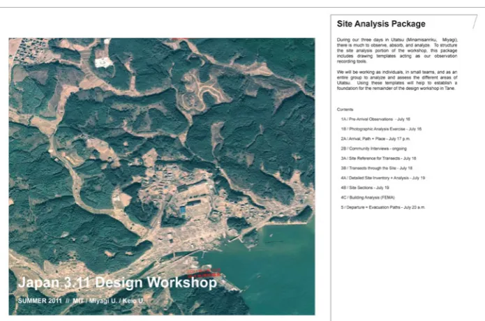
Tsunami damage and pilot study project
The site analysis and visual methods were tested in a pilot study that sought to identify potential sites for new community centres in a tsunami-devastated town in north-eastern Japan. The town of Utatsu is one of several major coastal settlements in the administrative district of Minamisanriku, in the Miyagi Prefecture of the Tohoku region (Figure 1). The coastal landscape of Minamisanriku consists of steep watersheds that drain the southern tip of the Kitakami Mountains in eastern Honshu Island. It has a rias (‘drowned’ or ‘sawtooth’) coastline with highly productive artisanal fisheries in a large number of small coastal settlements. The steep hillslopes have an evergreen forest cover (Pinus thunbergii) and deliver abundant sediment to valley floors that, before the tsunami, supported rice paddies and discharged onto small coastal plains that had mixed residential, commercial, transportation and civic development.
alluvial coastal and riparian flats were developed, streams were channelised and evacuation scenarios were not sufficiently tested; and, therefore, many settlements could not cope with the unprecedented magnitude of the earthquakes and tsunami in March 2011.
The earthquakes and tsunami struck on 11 March 2011. The greater Sanriku coast in eastern Honshu was directly and severely impacted, with wave elevations and run-up along river valleys of more than 15 metres above mean sea level (Mikami, Shibayamay and Esteban, 2012, p 4). The number of dead and missing in Minamisanriku Town was estimated to be about 900 out of a population of just over 17,000 (ibid, p 6). Devastation of coastal buildings was nearly total. Regional Japan Rail tracks and coastal highway bridges were knocked down. Saltwater inundation damaged agricultural and forest vegetation. Massive amounts of debris from the built, cultural and natural landscape posed challenges for recovery. Six months later, the Miyagi Prefectural Government (2011, p 2) released a disaster recovery plan that called for new methods of reconstruction planning and design.
Pilot study aims
On 12 March, the day after the great north-eastern earthquakes and tsunami, architecture faculty from Miyagi University approached colleagues at Massachusetts Institute of Technology (MIT) in Cambridge, Massachusetts, to organise a joint reconstruction design studio. Initial reconnaissance trips and contact with community officials and members, followed by weekly Skype conversations, sought to identify a town, project type and approach for a pilot
7 J A M E S L W E S C O A T J R A N D S H U N K A N D A
study. As the government of Japan had placed a moratorium on rebuilding pending larger-scale policy and planning decisions, the organisers of the design studio decided to focus on the expressed need for ‘community centres’ with an emphasis on small towns that had lost much of their civic space as well as housing and infrastructure.
This pilot study explores what hazards researcher Gilbert White termed ‘the range of choice’ among reconstruction alternatives (Mitchell, 2008; Wescoat, 1987, 2011; White, 1961). White observed that reconstruction often occurs on sites subject to repeated risk and focuses quickly on a single alternative that overlooks other possibilities. The location of a post-disaster community centre, for example, might begin with assumptions about a high-elevation, high-visibility site. While this is a reasonable option, the sensitivity of high-elevation areas provides an argument for exploring alternatives.
The ‘range of choice’ phase of site analysis focuses on site conditions that help expand the perceived array of community building possibilities, opportunities and constraints. The community building programme was not pre-specified and was itself a variable discerned in part through the process of site analysis, community observations and discussion.
Review of post-disaster site analysis research
Peer-reviewed research on site analysis in post-disaster contexts is limited, so we examined research on tsunami reconstruction and site analysis methods. The former body of research is extensive. The Avery Index of Architectural Periodicals alone yielded 82 peer-reviewed hits that included significant contributions by landscape architects and planners, for example, Mazereeuw (2011) and Mitani, et al (2011) (see also National Research Council and National Academy of Environmental Design, 2010). The Tohoku Geographical Association published assessments of tsunami damage and reconstruction planning including geographic information systems (GIS) mapping in the Onagawa port area (Ikoda, 2011; Mimura, et al, 2011; see also Kyoto University, 2012). The American Society of Civil Engineers (ASCE, 2011) conducted multi-team rapid reconnaissance in the Minamisanriku area. The Indian Ocean tsunami of 2004 also generated a large volume of evaluation literature (ALNAP, 2007; Jayasuriya and McCawley, 2010). In a study comparable with this one, but covering a much larger region, Free (2005) developed site analysis checklists for reducing seismic–tsunami risk when siting facilities.
For previous research on site analysis methods, a bibliographic search was conducted in the following major interdisciplinary journal indexes:
• Avery Index for Art and Architectural Periodicals; • Engineering Village (Compendex);
• Web of Knowledge (including Science and Humanities indexes); • WorldCat – books and articles.
Index Key words Gross hits
Avery (art, architecture) ‘Site analysis’ anywhere 12 Compendex (engineering) ‘Site analysis’ in title or abstract 13; 21
ArticleFirst (interdisciplinary)
‘Site analysis’ as key word AND ‘landscape’ OR ‘hazard’ OR ‘disaster’
99; 47; 26
Web of Knowledge (science, humanities)
‘Site analysis’ as topic AND ‘landscape’ OR ‘hazard’
26; 29; 3
In this case, the Avery Index yielded only 12 hits on ‘site analysis’, none of which dealt with hazards.3 Four of the hits were reviews of James LaGro’s 2007 influential textbook Site Analysis: A Contextual Approach to Sustainable Land Planning and Site Design. We cross-checked the Avery results with searches of online journal archives and obtained further results: Landscape and urban planning (36 hits); Landscape Research (10 hits); Journal of Landscape Architecture (3 hits); Landscape Journal (8 hits plus book and conference reviews). These results indicated several patterns of site analysis research:
• early research on terrain analysis in landscape assessment (Harris, 1988; Way, 1982);
• late twentieth-century frameworks for site interpretation vis-à-vis traditional site analysis (for example, Corbin, 2003, on the significance of vacancy; Francis, 2001, on landscape architectural case studies; Meyer, 2001, on Marcel Smets’s ideas about casco as a guiding concept for seeing; Braae and Diedrich, 2012, on the concept of site specificity; and National Research Council and National Academy of Environmental Design, 2010); • continuing development of spatial analysis, computer cartography and GIS applications (for example, Jun, 2000; Mutunayagam, 1986; and Showalter and Lu, 2010).
The Compendexindex added technical studies of facilities siting, site analysis failures and site analysis in environmental restoration (for example, Anon, 1985; Miron, Rutz and Ray, 2007; Powers, 1981). The Miron, et al (2007) article, in particular, describes a semester-long site analysis course at Tuskegee University in Tuskegee, Alabama, on radiation and hazardous waste hazards assessment. General article indices, such as the ArticleFirst and Web of Knowledge, added important research on GIS methods in siting emergency evacuation shelters (Kar and Hodgson, 2008); remote sensing of seismic hazards in site analysis (Xu, et al, 2010); landslide susceptibility (Gabriele, Barchiesi and Catallo, 2009); avalanche hazards simulation (Bocciola, Medagliani and Rosso, 2009); and sustainable site planning for disaster risk reduction (Ozdemir, 2008).
The PreventionWeb of the United Nations International Strategy for Disaster Reduction (UNISDR) yielded 82 hits on site analysis in disaster risk reduction websites. UNISDR (2006) also produced a Tsunami Bibliography in the wake of the 2004 Indian Ocean tsunami. A study by the National Tsunami Hazard Mitigation Program (2001, p 22)highlightedthe role of site analysis in tsunami preparedness:
The site analysis phase can be used to establish site plan parameters for tsunami mitigation. Many communities have mapped hazard areas. Within these areas, communities may also have more detailed plans that include site analysis. The analysis typically includes geographic conditions, critical infrastructure (see
9 J A M E S L W E S C O A T J R A N D S H U N K A N D A
Principle 6), area access and egress (see Principle 7), and existing and future development patterns. The analysis may also include economic feasibility and community design objectives.
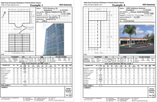
Because our study emphasised visual methods conducted by non-expert design students and faculty, it also drew upon the Rapid Visual Screening of Buildings for Potential Seismic Hazards: A Handbook by the US Federal Emergency Management Agency (FEMA) (2002) (Figure 2). That volume developed visual assessment techniques for screening potential seismic hazards in buildings and, thus, differs in subject and purpose from our study of site alternatives in post-disaster contexts; however, they share an emphasis on rapid visual screening methods. Our study identified the presence and absence of tsunami damage and debris to identify different types of sites for potential community use.
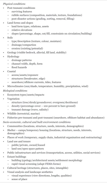
The literatures surveyed above were used to adapt the site analysis variables listed in LaGro (2007) and other environmental planning texts (for example, Marsh, 2010; Murphy, 2005; White, 2004) and to incorporate post-tsunami landscape disturbance and siting considerations (Table 2).
Site analysis methods
The site analysis methods were developed in three phases. The first involved off-site preparation, compiling and studying base maps, satellite imagery before and after the tsunami, supporting data, and field logistics before arrival. The second phase involved design and implementation of the on-site transect analysis procedures. The third phase involved off-site studio synthesis of fieldwork results. These methods are elaborated in further detail below.
Preparatory phase of site analysis
Site information is often inaccessible, damaged or destroyed in post-disaster landscapes, which means intensive preparation is required before arrival on site. The Japan 3.11 workshop preparatory analysis included the following.
1. The international team’s aims, scope, methods, logistics and funding were coordinated through Skype and telephone conversations held nearly each
Table 2: Site analysis variables. Physical conditions
• Post-tsunami conditions
– surviving features
– rubble surfaces (composition, materials, texture, foundations) – post-disaster actions (grading, sorting, removal, filling) • Land forms and slopes
– land form types, relations, assets – relative elevations
– slopes (percentage, shape, cut/fill, constraints on circulation/building) • Soils
– type/description (texture, colour, moisture) – drainage/compaction
– erosion (existing/potential)
• Geology (visible bedrock, alluvial, fill land, stability) • Hydrology
– drainage patterns
– channel width, depth, form – flood hazards
• Coastal
– access/assets/exposure – structures (breakwater, edge)
– nearshore/offshore currents, tides, features
• Microclimates (sun/shade, temperature, humidity, precipitation, wind) Biological conditions
• Ecosystem types/assets/impacts • Vegetation
– structure (tree/shrub/groundcover; evergreen/deciduous)
– density (percentage cover – 100 percent to bare ground) – tsunami damage (wave, salinity)
• Wildlife (terrestrial, marine)
• Fisheries pre-tsunami and post-tsunami (nearshore, offshore habitat and abundance) Socio-economic, cultural and built environment conditions
• Communities (locations, structure, needs, interests, demographics)
• Shelter – camps/temporary housing (locations, structure, needs, interests,
demographics)
• Places of work (temporary, supply chain, industrial organisation and restructuring)
• Land use and tenure
– public/private, owned/leased – land use/open space pattern
• Public infrastructure and services (transportation, access, utilities, social services)
• Extant buildings
– building typology/architectural assets/settlement morphology – rapid visual screening (adapt FEMA forms)
• Cultural heritage (structures, places, sites, intangible)
• Visual analysis and landscape aesthetics
11 J A M E S L W E S C O A T J R A N D S H U N K A N D A
week for several months before the workshop. These deliberations and reconnaissance visits led to the selection of Utatsu, one of three main towns in Minamisanriku (the others being Shizugawa and Togura; there are many other small settlements like Minato and Hadenya; and an inland town at Iriya). It also led to the decision to focus on the need for small community centres. 2. Preparatory meetings were held with workshop members that addressed the
potential hazards of field work (earthquake aftershocks; typhoon storms in late summer; scientific information about radiation plumes in the atmosphere, water, land and food chain; tsunami debris hazards and general first aid). 3. A ‘Resource-CD’ was compiled for workshop members, which included:
01_Key Workshop Documents (for example, schedule, contact information, project brief)
02_Base Maps (at multiple scales and geographic extents, from satellite imagery to Japan’s Zenrin topographic maps at 5-metre contour intervals) 03_Site Analysis Resources (for example, literature review above)
04_2011 Tohoku Earthquake and Tsunami Documents (initial damage assessments and monitoring data)
05_Japan Disaster Research and Management Resources (institutional mapping of Japanese government and non-governmental aid organisations involved in Tohoku earthquake and tsunami recovery; list of Japanese disaster research centres and downloaded publications)
06_Technical Disaster Resources (for example, FEMA manuals and US Army Corps of Engineers Coastal EngineeringManual)
07_Disaster Resilient Design Resources (for example, design precedents database from the United Nations Human Settlements Programme (UN-HABITAT), Active Learning Network for Accountability and Performance in Humanitarian Action (ALNAP), Architecture for Humanity and 2004 Indian Ocean tsunami case studies).
These digital resources were deemed important because internet access was negligible in Minamisanriku during the early months following the tsunami disaster.
4. Base maps were selected and printed at multiple scales to provide a perspective of the regional context as well as for site analysis. The three main scales selected were the:
• full Minamisanriku administrative area, which consolidates the three main towns and their coastal watersheds;
• greater Utatsu area, which comprises the formerly settled coastal bay, middle terraces that support the town’s schools and emergency housing, upper forested hillslopes and riparian corridors that drain the hillslopes to the coastal bay;
Cartographic resources for the Utatsu area were greater than what would have been available a decade ago but still limited. For example, Google Earth historical maps and images, and tsunami inundation maps, were available soon after the event. However, Zenrin topographic base maps for coastal towns were available at a 5-metre contour interval, which provided limited information on buildable or evacuable slopes. The Utatsu area did not have GIS coverage for land use or land cover.
5. Site analysis field drawing packages were prepared for all participants (12 pages of pre-formatted field mapping sheets linked with daily fieldwork at 297 × 420 millimetres (A3)). These drawing sets enabled continuous mapping, note taking and drawing while site transects were walked (Figure 3).
On-site analysis
The US–Japan design team travelled by road from Sendai to Minamisanriku. The initial arrival on site began with silent meditation and an intuitive walk through the coastal area, adjacent river valleys and upland settlements without photography, discussion or analysis. This first step was suggested by our Japanese project leaders as an appropriate way to begin. It resonates with the interpretive cultural traditions of site inquiry noted above, and is important for responders as well as survivors in post-disaster contexts (Aloudat and Christensen, 2012; Hewitt, 2012).
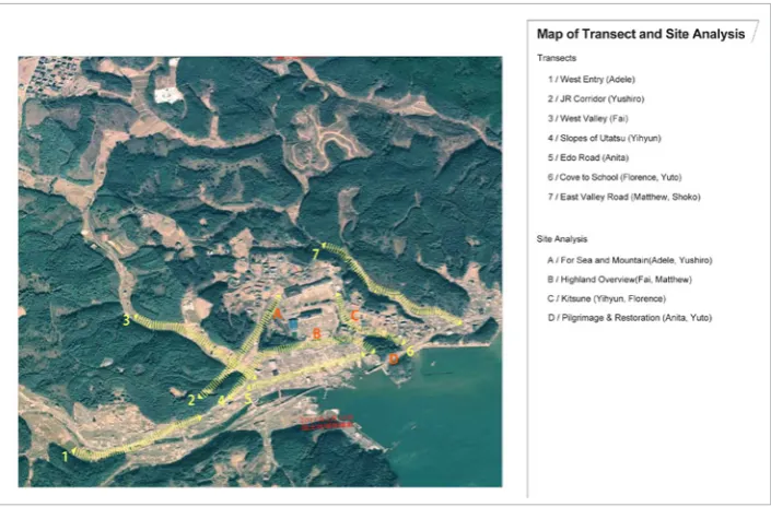
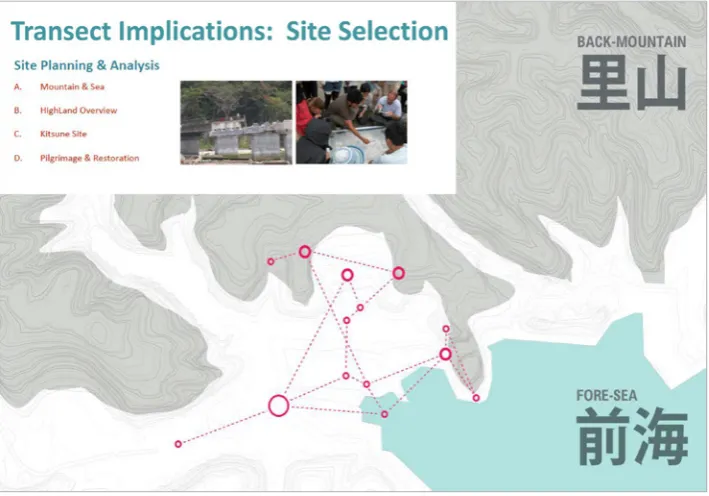
Day 1: Transect analysis. Site analysis teams of two to four members analysed one transect each of nearly 0.5 kilometres in length (the distance from sea to upper settlements or steep forested slopes). Transect methods were demonstrated in the field (for example, delineation of sections, distance pacing, slope and height estimation, documentary photography and annotation). Seven transects were selected based on Minamisanriku’s complex terrain; they followed or cut across major ridge and valley land forms in a gridded alignment that might be more applicable in gentler terrain (bracketed numbers below refer to transect numbers in Figure 4). The transects included:
• three riparian corridors (the main stream valley [1], west valley [3] and east valley [7]), which supported rice cultivation and limited settlement;
13 J A M E S L W E S C O A T J R A N D S H U N K A N D A
• three transportation corridors (the Japan Rail line [2], an historic coastal road [5] and a small road from a coastal cove to upland school buildings [6]); • a series of six hillslope sections [4], most of which were sharp barriers to
evacuation and settlement, though several had paths or small switchback roads to upland areas and midslope terraces that escaped tsunami damage and served important community functions.4
As a rias coast, with steep mountain drainages and heavily forested hilltops, Utatsu has a limited buildable area and significant barriers to vertical evacuation.
Transect analysis is a method of site sampling that intensively examines conditions observable over linear paths through a study area. It is widely employed in geomorphology, biogeography, disturbance ecology and built environment research (for example, Buckland, 2001; Goudie, 1990; Kent, et al, 1997; and www. transect.org where land use transects are linked with development codes). In this project, transect analysis entailed the following field tasks.
• Longitudinal sections were constructed along the transect line. Longitudinal transects looked in both directions from the centre line to evidence at a visible distance from, as well as immediately along, the section line (these drawings used conventions of lighter lines for more distant information). As transects followed rather narrow paths, this background information ranged from 5 to 50 metres from the centre line (Figure 5).
• Transverse sections were constructed across the transect line at intervals selected to identify major construction constraints (for example, slopes greater than 30 degrees, the ocean and densely forested areas) and opportunities (for example, elevated open areas, trafficable slopes and attractive sight lines) (Figure 6).
• Surface conditions (damage, debris, land use and land cover) were mapped on a gross scale between the transverse sections to the boundaries of the visible evidence.
Figure 4: Transects identified in yellow
In each section and plan, the aim was to identify slope conditions affecting evacuation, damage and debris patterns that indicated relative safety in this event, and areas of around 20 square metres or more that might support community activities. This one-day survey along a well-defined transect helped each team develop a fine-grained perspective on post-disaster landscape conditions, forensics, opportunities and constraints. The information recorded was collected by direct observation while walking transects repeatedly to gain insights from viewing transects in different upslope and downslope directions.
In the evenings, teams attended community meetings in the towns of Utatsu and Togura for insight into redevelopment interests and concerns. They compared hand-drawn transect maps and sections, which had two main benefits. First, it indicated more and less successful drawing and mapping techniques. Participants showed creativity in annotation methods, map symbols, observational acuity and supporting analysis (for example, the slope analysis matrix in Figure 7). Comparing preliminary transects also helped develop a collective understanding of the complex terrain of Utatsu (as indicated in Figure 4 above).
Day 2: Potential community spaces along the transects. In the morning of the second day, teams re-surveyed transects for missing data and inferences about pre-disaster development patterns, tsunami damage processes and reconstruction prospects. The teams then tested the fruitfulness of these methods by identifying potential community spaces along each transect. Draft site planning criteria and programme possibilities were informed by discussions with local residents and the evening meetings with community members. These discussions revealed diverse
15 J A M E S L W E S C O A T J R A N D S H U N K A N D A
interests and attitudes. Some community members sought to resume coastal fishing livelihoods as soon as possible while others wanted to relocate away from the ocean – visually as well as spatially. This combination of diverse views and complex terrain supported the approach of expanding the range of community spaces considered rather than seeking to identify a single site as the community centre. Potential sites identified along the transects are described below.
• The three riparian corridors yielded important information about tsunami damage caused by ‘run-up’ that swept away bridges, buildings and rice fields, as well as hillside ‘splash-up’ that aggravated salinity impacts on pine forests. In light of this severe damage and the steep sideslopes, no community centre spaces were identified along the east or west valley transects. However, the mouth of the main riparian corridor was identified as an estuarine restoration area that could link the reconstruction of community fishing livelihoods and workplaces with environmental education and recreation. This coastal lowland site had not been anticipated at the outset of inquiry and thus its inclusion expanded the range of choice.
• The three transportation corridors also suffered major structural damage from direct tsunami wave forces. Japan Rail tracks were torn off; highway bridge structures and buildings along the old Edo-period road on the coastal plain were destroyed. However, the cove to school road team identified variable damage patterns, including areas where small differences in exposure resulted in differential damages and protection. Each transportation corridor team identified protected areas that could support
community activities. The Japan Rail team identified a small upland site adjacent to the rail line used for overflow parking that was protected from, yet had partial views of, the ocean, which could serve the varied wishes of residents with respect to views of the ocean. Another team identified an upland site adjacent to the school road that had a small abandoned play area suitable for redevelopment. The coastal road team suggested that restoration of highway corridor cut slopes could accommodate some of the massive volume of debris along the coastline and could, in turn, re-link a hilltop Shinto shrine with a high coastal promontory park. Although the first two sites might have been discovered through other methods, their strong linkages with potential evacuation routes and adjacent community land uses were identified through transect analysis. The alternative for restoring a highway cut through the coastal headlands had not been imagined at the start of the project.
• The hillslope sections identified a promising community site on a central axis from the former town centre through the middle terrace with surviving schools and emergency housing. This central location, served by an existing road, was envisioned at the outset of the inquiry. However, the transect slope analysis identified opportunities for lower slope reconstruction with tsunami-deposited debris and access and/or evacuation road improvements. In these ways, transect analysis helped advance the concept and substance of expanding the range of choice. It identified two completely unanticipated sites, two unanticipated sites that might have been identified through different methods
Figure 7: Slope analysis and
classification matrix. (Image courtesy
17 J A M E S L W E S C O A T J R A N D S H U N K A N D A
but that were closely linked with evacuation paths through transect analysis, and one anticipated site whose opportunities and requirements were innovatively elaborated through transect analysis.
Day 3: Departure and reflection. Field work ended with reflections similar to the way that it began. The team had a silent departure with reflections on leave-taking, reconstruction and return. The analytical field methods were thus bookended by contemplative experience. While the methods described above emphasise the analytical approach, the importance of subjective experience deserves comment. Participants underscored their reflections on, as well as observations of, the patterns of devastation – and a sense of promise in the alternatives identified. They reported that these emotive aspects of field work shaped the interpretive level of transect analysis, and that balancing the reflective, analytical and descriptive aspects of site analysis is important for imagining the potential implications of site conditions.
Off-site analysis workshop methods
Following the field work, the team lived for three days in a Zen monastery in Kyoto, continuing to reflect in part on landscape analysis, experience and alternatives at Utatsu. The design workshop then resumed off-site for three weeks where multi-university teams transcribed field data into digital format and developed initial site planning concepts. One test of the rapid visual site analysis methods was whether team members would retain a high level of clarity, detail and salience of site analysis knowledge during the off-site portion of the project. (A point of comparison was Orland and Bellafiore, 1990, where that did not occur, and where the authors reported that landscape experience and alternatives lost salience over time and with distance from the site.)
Evaluation and discussion
This section presents the participant and author evaluations of how well different site analysis materials and techniques performed in practice. Criteria for evaluation were whether a method or resource was used, participant comments about its utility and author judgements about its contribution toward the identification of site alternatives. We distinguish methods that worked well as planned, worked well when adapted, performed with mixed results or performed weakly.
Preparatory materials
The site analysis drawing set had an overall positive performance. Participants described the package as valuable for orientation in a complex post-disaster landscape, as an effective format for rapid recording when walking transect alignments and for comparing observations. Maps, plans and section worksheets were intensively used. The transect section methods worked well only after they were demonstrated in the field. The list of site analysis variables was deemed useful but would have been more so if reformatted as worksheets and checklists similar to those in some of the disaster literature reviewed above. Community meeting and personal reflection worksheets were used less. Although deeming them important, participants preferred other formats for note taking.
relevant project information, for example, base maps, but technical resources were little used. Its lack of use should perhaps not come as a surprise in a study that stresses visual methods, but we conclude that use of supporting scholarly information could be enhanced by establishing specific links with site analysis variables and hotlinks for ready access in the field.
On-site field methods
Overall, the transect analysis method worked well. Each team was able to cover the nearly 0.5 kilometre alignment in the time available and record detailed visible evidence on commonly formatted plans and sections. Each team succeeded in using site analysis to expand the range of community centre alternatives and justify further study of those possibilities with fine-grained analysis. As emphasised above, rapid visual site analysis is an early phase of post-disaster reconstruction inquiry that must be followed by detailed site survey, screening, siting and planning.
Participants reported one way in which transect analysis as designed in this study was limited. Namely, time should have been allocated for all participants to undertake a rapid reconnaissance of all transects. Although the transects had several points of intersection, particularly in the coastal lowlands, which gave some sense of connectivity, the team concluded that expanding the range of choice is not merely an additive process but also one of envisioning combinations of site alternatives, for example, in networks or constellations of community spaces in Utatsu (Figure 8).
Again, participants reported favourably on the balance between descriptive, analytical and interpretive methods in the transect analysis. They stressed the challenges of maintaining that balance in post-disaster field work and indicated that each mode of site inquiry contributed separately and jointly to the aim of expanding the range of site alternatives worthy of further consideration.
Figure 8: Constellation of community
centres and spaces identified in Utatsu,
19 J A M E S L W E S C O A T J R A N D S H U N K A N D A
Off-site synthesis
Site analysis and planning methods employed after the field work had mixed results. On the positive side, the field-based site analysis work appeared to retain its salience and clarity for participants and in the evaluation of project leaders. Few expressed concerns about information gaps or deficiencies for the purposes of this initial pilot study. The main challenges involved changes in team membership that included the departure of some field researchers and arrival of others who had not participated in the field work. These challenges could be mitigated to an extent by more robust field drawing and annotation methods. The final section of this paper identifies further extensions of rapid visual site analysis methods for post-disaster landscape planning and design.
Future extensions
Future research should enhance and test the replicability of methods employed at Utatsu. Enhancements could include refined field worksheets, stronger links with supporting scientific data and testing of alternative recording methods (for example, audio and/or video and tablet computing platforms). In substantive terms, it is important to determine how rapid visual assessment performs in different types and sizes of towns, for example, from the large municipal centre of Shizugawa to small fishing settlements such as the Hadenya area of Togura in Minamisanriku.5 Further testing of transect methods for their robustness
across different types of terrain is also necessary, for example, from rocky coastal headlands to the flat Sendai coastal plain. Future research must link visual site analysis with community-based methods of post-disaster landscape planning. Finally, in light of the hundreds of small coastal communities affected by disasters such as the Tohoku earthquake and tsunami, priority should be given to the adaptation of rapid visual site analysis methods for numerous small teams of local designers and community members.
Acknowledgements
The authors gratefully acknowledge the co-leadership of Professor Yoshihiro Hiraoka of Miyagi University. Professor Hiroto Kobayashi and his team from Keio University also contributed. The MIT team benefited from generous funding from the MIT Japan 3.11 Initiative, Department of Architecture and Aga Khan Program for Islamic Architecture at MIT, Japan Disaster Relief Fund – Boston, Geraldine Kunstadter, and Japan Foundation Center for Global Partnership. Emily Lo helped design the site analysis drawing templates and Shoko Takemoto MCP helped with community meeting minutes and translations. Architect Saya Suzuki was an invaluable teaching assistant. Professor Jacky Bowring, Matthew Bunza and three anonymous reviewers provided helpful criticism and recommendations. Student participants from MIT, Miyagi and Keio universities devoted themselves to testing these disaster mitigation site analysis methods and expanding the range of choice.
NOTES
2 After screening to eliminate unrelated terms (for example, in the fields of chemistry, biology, physics), false hits (‘web site analysis’) and related terms that denote different types of environmental site analysis (‘on-site analysis’, ‘multi-site analysis’). 3 These limited results may reflect the move away from site analysis and related survey analysis and design methods in late twentieth-century practice (for example, Turner, 1991; though see response by Stiles, 1992). In the journal searches, new approaches were sometimes contrasted with ‘conventional’ or ‘traditional’ site analysis. Interestingly, one article included a critic’s argument that site analysis was not research because it compiles existing knowledge and does not create new knowledge, which the critic deemed a matter of practice rather than research (Milburn and Brown, 2003).
4 Technically, the hillslope analysis follows an irregular alignment along the toe of slopes rather than a straight line and is not a ‘transect’ in a strict sense but rather a series of mini-transects cut where lower hillslopes meet the coastal plain.
5 Enhanced methods were tested in the settlement of Hadenya in August 2012 that included circuit and thematic areal analyses to complement transect and siting methods.
REFERENCES
Active Learning Network for Accountability and Performance in Humanitarian Action (ALNAP) (2007) Synthesis Report: Expanded Summary. Joint Evaluation of the International Response to the Indian Ocean Tsunami, London: ALNAP Technical Evaluation Committee.
Aloudat, T and Christensen, L (2012) Psycho-social Recovery. In The Routledge Handbook of Hazards and Disaster Risk Reduction, B Wisner, JC Gaillard and I Kelman (eds), London: Routledge, pp 569–579.
American Society of Civil Engineers (2011) Japan earthquake/tsunami reconnaissance teams, April 2011. Accessed 25 October 2012, www.asce.org/PPLContent.aspx?id=12884906436
Anon (1985) Inadequate Site Analysis Caused Dam Failure, World Construction 38(8), pp 38–39. Bocchiola, D, Medagliani, M and Rosso, R (2009) Use of a Regional Approach for Long-term Simulation of Snow Avalanche Regime: A Case Study in the Italian Alps, Arctic, Antarctic, and Alpine Research 41(3), pp 285–300.
Braae, E and Diedrich, L (2012) Site Specificity in Contemporary Large-scale Harbour
Transformation Projects, Journal of Landscape Architecture 7(1), pp 20–33.
Buckland, ST (2001) Introduction to Distance Sampling: Estimating Abundance of Biological Populations, New York: Oxford University Press.
Corbin, CI (2003) Vacancy and the Landscape: Cultural Context and Design Response, Landscape Journal 22(1), pp 12–24.
FEMA (2002) Rapid Visual Screening of Buildings for Potential Seismic Hazards: A Handbook
(2nd edn), FEMA 154/155. Washington, DC: United States Federal Emergency Management Agency. Francis, M (2001) A Case Study Method for Landscape Architecture, Landscape Journal 20(1), pp 15–29.
Free, M (2005) Earthquake Hazard Assessment – Some Lessons Learned from the December 2004 Sumatra–Andaman Islands Earthquake and Indian Ocean Tsunamis, 67th European Association of Geoscientists and Engineers – Extended Abstracts, pp 1361–1363.
Gabriele, L, Barchiesi, F, Catallo, F, Dramis, F, Fubelli, G, Lucifora, S, Mattei, M, Pezzo, G and Puglisi, C (2009) GIS Methodology to Assess Landslide Susceptibility: Application to a River Catchment of Central Italy, Journal of Maps 2009, pp 87–93.
Goudie, A (1990) Geomorphological Techniques,Abingdon, UK: Routledge.
Harris, T (1988) Digital Terrain Modelling and Three-dimensional Surface Graphics for Landscape and Site Analysis in Archaeology and Regional Planning, Computer and Quantitative Methods in Archaeology 1987: CAA87, pp 161–170.
21 J A M E S L W E S C O A T J R A N D S H U N K A N D A
Ikoda, Y (2011) Moving the Whole Town up Hill: An Algorithmic Search of Developable Land in Tsunami-hit Onagawa Town, The 2011 East Japan Earthquake Bulletin of the Tohoku Geographical Association. Accessed 25 October 2012, http://tohokugeo.jp/disaster/articles/e-contents19.html Jayasuriya, S and McCawley, P (2010) The Asian Tsunami: Aid and Reconstruction after a Disaster,Cheltenham, UK: Edward Elgar Publishing with the Asian Development Bank Institute. Jun, C (2000) Design of an Intelligent Geographic Information System for Multi-criteria Site Analysis, URISA Journal 12(3), pp 21–41.
Kar, B and Hodgson, ME (2008) A GIS-based Model to Determine Site Suitability of Emergency Evacuation Shelters, Transactions in GIS 12(2), pp 227–248.
Kent, M, Gill, W, Weaver, RE and Armitage, RP (1997) Landscape and Plant Community Boundaries in Biogeography, Progress in Physical Geography 21(3), pp 315–353.
Kyoto University (2012) Tohoku Research 1: Post-disaster Recovery, Kyoto University, Kyoto,
Japan. Accessed October 2012, www.preventionweb.net/files/27633_tohokuresearchgroupkyotoun
iversity.pdf
LaGro, J (2007) Site Analysis: A Contextual Approach to Sustainable Land Planning and Site Design (2nd edn), New York: John Wiley & Sons.
Marsh, W (2010) Landscape Planning: Environmental Application (5th edn), New York: John Wiley & Sons.
Mazereeuw, M (2011) Preemptive Landscape: A Prototype for Coastal Urbanization along the Pacific
Ring of Fire, Topos (76), pp 82–85.
Meyer, E (2001) Review of the Conference on: Territories: Contemporary European Landscape Design Harvard University Graduate School of Design, Cambridge, Massachusetts, 19–21 April 2001, Landscape Journal (20), pp 201–204.
Mikami, T, Shibayamay, T and Esteban, M (2012) Field Survey of the 2011 Tohoku Earthquake and Tsunami in Miyagi and Fukushima Prefectures, Coastal Engineering Journal 54(1), pp 1–26.
Accessed 25 October 2012, www.worldscientific.com/doi/pdf/10.1142/S0578563412500118
Milburn, LS and Brown, RD (2003) The Relationship between Research and Design in Landscape Architecture, Landscape and Urban Planning (64), pp 47–66.
Mimura, N, Yasuhara, K, Kawagoe, S, Yokoki, H and Kazama, S (2011) Damage from the Great East Japan Earthquake and Tsunami – A Quick Report, Mitigation and Adaptation Strategies for Global Change 16(7), pp 803–816.
Miron, A, Rutz, E and Ray, P (2007) Site Analysis and Environmental Restoration, ASEE Annual Conference and Exposition, Conference Proceedings, 2007 ASEE Annual Conference and Exposition.Accessed 25 October 2012, www.icee.usm.edu/icee/conferences/asee2007/ papers/519_SITE_ANALYSIS_AND_ENVIRONMENTAL_RESTORAT.pdf
Mitani, H, Shinozawa, K, Takahashi, S and Tanabe, Y (2011) Tsunami Landscape: Reflections from
Japan, Topos (76), pp 77–81.
Mitchell, JK (2008) Perspectives on Alternatives: Differentiation and Integration in Pursuit of a Better Fit between Society and Nature, Mini-forum on the Contributions of Gilbert F. White,
Progress in Human Geography 32(3), pp 451–458.
Miyagi Prefectural Government (October 2011) Miyagi Prefecture Earthquake Disaster Recovery Plan: The Bond between Miyagi, Tohoku and Japan – from Recovery to Prosperity. Accessed 25 October 2012, www.pref.miyagi.jp/seisaku/sinsaihukkou/keikaku/keikakugaiyou_en.pdf Murphy, MD (2005) Landscape Architecture Theory: An Evolving Body of Thought, Long Grove, IL: Waveland Press.
Mutunayagam, NB (1986) Cartography and Site Analysis with Microcomputers: A Programming Guide for Physical Planning, Urban Design, and Landscape Architecture. New York: Van Nostrand Reinhold.
National Research Council (United States) and National Academy of Environmental Design (United States) (2010) Disaster-Resilient Design Workshop, 20 October 2010, Washington, DC. Accessed 9 December 2012, http://dels-old.nas.edu/dr/f30.shtml
Noh, T (1966)Sanriku Coast Prepared for Tsunami: A Preliminary Report on Men’s Defense against Natural Disaster. Accessed 25 October 2012, http://ir.library.tohoku.ac.jp/re/ bitstream/10097/44873/1/AA0045945066165.pdf
Orland, B and Bellafiore, VJ (1990) Development Directions for a Sacred Site in India, Landscape and Urban Planning 19(2), pp 181–196.
Ozdemir, A (2008) Preventing Natural Hazard Risks through Sustainable Site Design, Polish Journal of Environmental Studies 17(4), pp 457–462.
Powers, RD (1981) Fatal Accident Site Analysis, Proceedings of the Paving Conference 18th, University of New Mexico, Albuquerque, New Mexico, 7–9 January, pp 332–336.
Showalter, PS and Lu, Y (eds)(2010) Geospatial Techniques in Urban Hazard and Disaster Analysis, New York: Springer.
Sphere Project (2011) Humanitarian Charter and Minimum Standards in Humanitarian Response,
Rugby, UK: Practical Action Publishing.
Stiles, R (1992) Determinism versus Creativity, Landscape Design (212), pp 30–32.
Turner, T (1991) The SAD Design Method vs Pattern Analysis And Design, Landscape Design Issue
#204 (updated and edited with additional essays). Accessed 25 October 2012, www.gardenvisit. com/history_theory/garden_landscape_design_articles/design_methods/sad_design_method UNISDR (2006) Tsunami Bibliography, Geneva: United Nations International Strategy for Disaster Reduction.
Way, DS (1982) Terrain Analysis: A Guide to Site Selection Using Aerial Photographic Interpretation (2nd edn),Stroudsburg, PA: Hutchinson Ross Publishing Company. Wescoat, JL Jr (2011) Disaster-resilient Design, Architecture, Design, Art 15, pp 77–83. ——(1987) The Practical Range of Choice in Water Resources Geography, Progress in Human Geography 11(1), pp 41–59.
White, ET (2004) Site Analysis: Diagramming Information for Architectural Design, Tallahassee, FL: Architectural Media Ltd.
White, GF (1961) The Choice of Use in Natural Resources Management, Natural Resources Journal
1, pp 23–40.
23 L A N D S C A P E R E V I E W 1 4 ( 2 ) P A G E S 2 3 – 3 3
Paula Villagra is Associate Researcher, Instituto de Ciencias Ambientales y Evolutivas, Facultad de Ciencias, Universidad Austral de Chile, Valdivia, Chile.
Telephone: 56–63–221344 Fax: +56–63–221344 Email: [email protected]
Eduardo Jaramillo is Professor, Instituto de Ciencias Ambientales y Evolutivas, Facultad de Ciencias, Universidad Austral de Chile, Valdivia, Chile.
Telephone: +56–63–221344 Fax: +56–63–221344 Email: [email protected]
KEY WORDS Volcanic eruption Chile
Environmental education Landscape narrative Landscape change
REFLECTION
After the 2011 eruption of the Puyehue-Cordón Caulle volcanic complex (PCC) in southern Chile, an exhibition was prepared to show to the general public the findings of academic expeditions in the area affected. This paper discusses the objectives and content of this expedition, as well as the interpretation tools used to prepare it. A volcanic system operates (generally unnoticed) at different times and scales, creating a landscape of great scenic beauty. However, it is also a system that changes dramatically and can become dangerous. The exhibition made these changes visible to the community by using photographs, videos and oral discussions to convey the effects of the eruption on the landscape. The objective was to educate people about the differences between temporal visual effects (which are not always harmful) and others that cannot be observed but can damage the environment and for which we must be prepared. The discussion provides insight into the extent to which interpretation tools and landscape narratives can contribute to a full understanding of the dynamics and changes of natural landscapes.
Landscape display and environmental education
Nowadays, a wide range of organisations deals with similar environmental challenges: to learn about and explore the natural world, and to re-interpret it into displays that can catch the attention of the public. For this purpose, acquired knowledge about nature needs to be transformed into environmental messages that can be conveyed to the general public in a useful way (Davis, 1996; Uzzell, 1989).
In the context of zoos, traditional cages are being transformed into habitats that replicate the environment of the animal species on display (for example, Valencia Biopark, Spain). Similarly, museums and botanical gardens are creating story-driven displays to heighten awareness of and concern about environmental issues (Davis, 1996; Falk and Dierking, 2002). Newer displays engage people with ecological processes that govern the natural environment (Monem, 2007; Villagra, 2011). In the same vein, universities have a responsibility to share research outcomes about the natural world with the public. In particular, they should share information about the direct effects of natural disturbances, using activities and messages that the non-academic community can easily understand and access.
The recent changes in the way the natural world is displayed are a response to global strategies developed by the Convention on Biological Diversity in June
Environmental Education through
an Interdisciplinary Approach:
The Effects of the Volcanic Eruption
of the Puyehue-Cordón Caulle
Volcanic Complex on the Landscape
of Southern Chile
1992 at the United Nations Conference on Environment and Development, Rio de Janeiro, Brazil (Secretariat of the Convention on Biological Diversity, 2002). These strategies have influenced the objectives of organisations around the world that care about our ecological diversity. The aim is to use innovative environmental interpretation tools to enhance people’s understanding of and relationship with the dynamics and elements of nature. Thus the concept of interpretation is as an ‘educational activity which aims to reveal meanings and relationships through the use of original objects … rather than simply to communicate factual information’ (Tilden, 1977, p 8). It can be more effective if people are engaged with the topic of exhibitions through their own personal characteristics and values. In addition, the message needs to be narrated through appropriate media (Chang, Bisgrave and Liao, 2008); indeed, improving people’s interpretation of environmental phenomena and associated effects can be a highly effective way of diminishing environmental risk and improving their environmental behaviour. When they are aware of the dynamics and effects of natural disturbances in their surroundings, communities have a more accurate understanding of the risks and are better prepared to initiate the process of hazard adjustment (Lindell and Perry, 1993).
However, improving the environmental interpretation of the dynamics of nature – including the timeframe in which they occur and the scale of their effects – is not an easy task because landscape change is usually slow, visible only after a period longer than the human life cycle (Bell, 1999). In addition, the scale of change may be too small or too big for people to see. To counteract these difficulties, scholars have suggested that exhibitions can be shaped as a story of natural processes, by using representative parts of the environment that people can understand easily (Potteiger and Purinton, 1998; Spirn, 1998). Also potentially useful are heuristic devices such as visual conceptual maps or graphs (Corner, 1999; Soliva, 2007). These and similar techniques are used to teach people to ‘read’ the landscape from new perspectives.
In the process of creating new exhibitions, it is important to consider that people can misunderstand environmental messages when the ‘medium’ becomes the ‘message’ (Uzzell, 1989). For example, where technology is overused, it becomes overwhelming and also conveys the wrong meaning. In the case of the Eden Project in the United Kingdom (Eden Project, 2009), for example, visitors engage with the exhibit itself instead of focusing on the topic of the display. Other, less provoking exhibitions can go completely unnoticed (Davis, 1996), creating a different kind of problem for communication.
25 P A U L A V I L L A G R A A N D E D U A R D O J A R A M I L L O
The Puyehue-Cordón Caulle Volcanic Complex
The PCC is one of 500 active volcanoes of Chile (Sernageomin, 2011). It includes a strato volcano, a fissure zone and remnants of earlier Pleistocene volcanoes, all located in the Andean Southern Volcanic Zone at 40.5°S latitude (Singer, Jicha, Harper, et al, 2008). Its activity has been recorded from the Pleistocene to the present, with the latest three eruptions occurring in 1932, 1960 and 2011.
The area around the PCC corresponds to the lake region of Chile, characterised by the lakes Ranco and Puyehue and by rivers such as Iculpe, Muchi, Caunahue, Calcurrupe, Nilahue, Los Venados, Quiman, Coique, Riñinahue and Gol Gol. Foothills and valleys extend between 70 and 2,230 metres above sea level and a network of roads through them enables access to several small human settlements. The local economy is based on small-scale agriculture, fish aquaculture and tourism. This socio-ecological system was disrupted during the latest eruption of 4 June 2011. During this event, the temperature of several rivers rose, lakes were covered by pumice stone and entire human settlements were exposed to the effect of ashes. Indeed, the ash column reached 10 km high and affected the entire southern hemisphere. Ashes from the volcano reached Argentina, Uruguay, Brazil, South Africa, Australia and New Zealand, hindering daily human life, agriculture and air traffic activity across this region.
Following the day of the eruption, the media showed only images of destroyed landscapes, losing the opportunity to educate the community about the dynamics and process of the natural landscape in which they live. Yet the media can have a great influence on people’s perception of landscapes (Jensen and McPherson, 2008). Furthermore, incomplete information can contribute to misunderstandings in the community, influencing the manner in which people interact with the environment and the decisions they make that affect their life quality and security. These considerations were among those that motivated a group of academics to study and communicate about the effect of the eruption on the landscape used for tourism due to its visual attributes and on the freshwater habitats useful for fly fishing (Figure 1).
Expeditions and exhibition
This section offers an overview of the main results of each study, without describing the study methods and outcomes in detail. This content reflects the level of information that was most useful for preparing the story about the effects of the eruption of the PCC on the landscape.
The touristic landscape
The study was focused around Lago Ranco where most of the tourist attractions are concentrated. The area is readily accessible and the lake setting is well suited to water sports such as rowing, boating and swimming. In addition, nearby rivers support top-quality fly fishing, which is highly prized. Visitors can enjoy nature while travelling by horse or on foot. All these attractions become even more desirable when they can be experienced while looking at a stunning landscape that features water bodies, a diverse topography with depth of view, ever-green trees, signal natural features and a variety of bright colours. According to landscape perception studies, people are drawn to all of these attributes in a landscape (Da Pos and Green-Armytage, 2007; Kaplan, Kaplan and Ryan, 1998). Such attributes also contribute to an area’s restoration and recreation (Hartig, 2007).
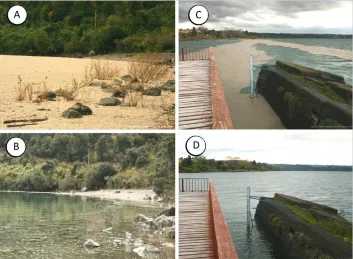
During June, August and October 2011 and January 2012, 26 sites in the area were photographed by following the rephotographic technique to record visual landscape change over time (Figure 2). The sites were selected among the three most visited tourist routes of the area. The first route (A = 120 km) included a circuit around Lago Ranco; the second route (B = 50 km) ran from Llifén to Lago Maihue; and the third route (C = 35 km) started in the village of Riñinahue and extended to Bahía Illahuapi (35 km) (see Figure 1 above). This approach was taken to obtain a representative and comprehensive record of the landscapes that support tourism in the area and to avoid biases introduced by the researcher while selecting study sites (see Daniel and Boster, 1976).
Comparisons of the same landscapes photographed in the days and months following the eruption suggest that basic visual features were indeed affected by the eruption. In areas where volcanic material such as pumice stone and ashes was found, changes were evident in: i) colour, varying from bright to dull; ii) line,
27 P A U L A V I L L A G R A A N D E D U A R D O J A R A M I L L O
changing from blurred to sharp; and iii) arrangement of spatial attributes that define focused and dominant landscapes, in contrast to the usual panoramic landscape of the area (Figure 3). Changes were observed in water bodies such as lakes and rivers, as well as in landscape borders, such as beaches and promenades. As the images recorded with the rephotographic technique show, visual change is only temporary and the landscape recovers its visual attributes over time.
In summary, the findings from the expeditions to the area suggest several landscapes that are useful to convey the effects of the volcanic complex over time. These landscapes change visually but only temporarily, such that they do not damage the visual attributes of the landscape that make it so attractive to people. In the long term, therefore, such changes do not affect tourism that is focused on the scenic beauty of the area. The observed landscapes are included in the tourist routes of the area; however, they are not considered in tourism planning as a source of scientific and educational tourism.
The freshwater habitats
Nearly three years before the volcanic eruption of PCC, researchers from the Institute of Environmental and Evolutionary Sciences had studied several rivers located around this volcanic area; that study included analyses of water quality,
Figure 2: Repeated photographs were taken from each site to the same vantage point after the eruption. Photographs were taken at eye level, in a horizontal position and with a 55 mm lens. The coordinates of each site visited were recorded with a Garmin GPS.
species richness and abundance of the freshwater macrobiota. Days after the eruption, therefore, they took advantage of that earlier work and moved to the field to repeat similar samplings at 14 river sites located to both the north and the south of the PCC (see Figure 1 above). Since then, samplings have been repeated during June 2011 and January, March, June and August 2012. The aim has been to analyse the effects of the eruption on water temperature and conductivity and on concentrations of total suspended particulate matter, silica and fluoride, as well as on the diversity and extent of aquatic insects and fish in the area. Because the eruption occurred during winter, flooding as well as fallout of volcanic material (pumice stone and ashes) contributed to the contents of particulate suspended matter on water during the first months following the eruption.
The results of the samplings show that rivers closer to the basement of the volcano had higher loads of pumice stone (Figure 4). In Nilahue River, for instance, samplings of the biota revealed a very low level of aquatic insects and a total absence of fish for several months after the eruption. In contrast, rivers somewhat further away from the basement of the volcano had lower loads of pumice stone (Figure 4). In addition, the diversity and extent of the biota were quite similar to those of rivers further away from the PCC or to the measurements gathered in the same rivers during the pre-eruption period (unpublished results). In general, the water of rivers closer to the basement of the volcano had higher temperatures and conductivities (that is, more salts). The concentrations of total suspended particulate matter, silica and fluoride were also higher (Table 1). This difference most probably has arisen because the rivers Nilahue and Gol Gol received a higher load of material from the eruption, either through the air (ashes) or from the material flushed from the volcano.
During the first months after the eruption of PCC, water quality was the main concern of local communities and of officials from the regional and local governments. Thus much effort was devoted to explaining that the higher content