AN IMPLEMENTATION OF LBS TO SENT AN
EMERGENCY MESSAGE, BASED ON GEO
POSITIONING SYSTEM
Shikha Chandrakar
1, Aakanksha S Choubey
2 1,2Department of Computer Science and Engineering
Shri Shankaracharya Technical Campus, SSGI (Faculty of Engineering and Technology)
Bhilai Chhattisgarh, (India)
ABSTRACT
The GPS positioning system is one of the most popular technology which provides many useful services to the
mobile user's. Anyone can get the positions in just a seconds. with help of this feature, there are many
applications are developed. With the help of GPS system a user can send an emergency messages to their
friends and other people who are linked with them. Here the proposed system is based on the location based
system, where a user can send an emergency message to their contact. When user click on the send button the
process will atomically find the nearest people who are in the contact list of the sender, and then the message
with the sender's current location will broadcast to all nearest contact person. The broadcast distance is set by
the sender. Based on the location send by the sender, the receiver's can trace the sender and reach.
Keywords: -
Location Based Service, LBS, Mobile location finder, Importance of LBS, Location
services.
I. INTRODUCTION
As all know that technology is incomplete without internet, it is backbone of technology. The location based
services is also based on the GPS system and internet. Location based services provide and interactive service
for the business as well as for the users. With using the concept of location based services, provides the
application user's to personalized services according to their current location. There are many applications are
developed in past with using the concept of location service for example finding the particular city or district on
map and the most popular is root finding while driving developed by Google. The e-commerce mobile
application use the location based service to know the user's current location and for delivery option. The
advertisement like Google adds also uses the location based system to display the user relevant adds.
Today almost all smart phone comes with GPS system. when a Smartphone user allow the location tracking, to
any application, the service or application can identify his or her location down to a street address without the
need for manual data entry [2]. The System uses the GPS based positioning system to get latitude and longitude
of current location of users. Location based administrations utilize constant geo-information to provide data
about the specific location. Location-based services use a Smartphone’s GPS technology to track a person's
location, if that person has allowed the service to do that. After a Smartphone user allow the location tracking,
the service can identify his or her location down to a street address without the need for manual data entry [2]
in any trouble or in any emergency. It broadcast the current location of sender, to all the friends or user with
only in just one click. The reviver received the message with the senders detail and location(longitude and
latitude). While sending the massage the proposed algorithm will create a cluster and send the nearest peoples
who is near to the sender.
Protecting a user's location privacy is an important part when using location based service. Users never want to
deal with the privacy while using the location based services, so there is need to implement an application which
is very high secure in terms of privacy. An important first step in protecting user's location privacy is notifying
them of requests for this information when the application ask for the location request [3].
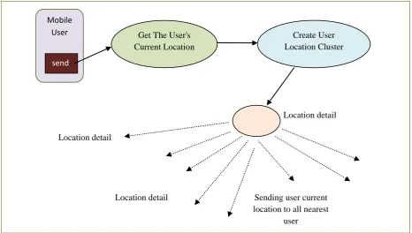
Sending the user's location:
With the help of the GPS, the developed model is able to get the user’s current location. To use the GPS and to
get the current location the mobile must be enable d with the GPS system and also the user must provide the
permission to use the location based service while installing.
Figure 1: Block diagram of creating user location cluster and sending the user location.
The developed model helps the user to send their current location while they are connecting with the internet.
When the user click on the send option the system internally connect with the GPS satellite and then the GPS
satellite will send the current location in the form of latitude and longitude. With the help of latitude and
longitude any one can easily get the actual location. After that, based on the current location the system will
create the “user cluster” based on their location.
II. LITERATURE REVIEW
There are a lot of research already done in the location based system. The successful of any research is
completely depends on the output of the complete process. Some of these are described below.
Mobile User
send
Get The User's Current Location
Create User Location Cluster
Location detail
Sending user current location to all nearest
user Location detail
The authors [4] present a research paper and implementation work based on the location based services. Almost
all android phone comes with the GPS enabled features. It provides an interactive to use the location based
services for smart phone. It also provide a way to integrate the Google map with the application developed
based on LBS. The background process runs continuously to check the users location and to map with the saved
location to determine the alarm(reminder) activity [4]. Android provides a functionality like Process
Controller, Notification manager, Connectivity manager, Location manager, SQLite database manager etc. This
functionality helps the developers to customize their application based on the requirements. The location based
reminder system is one of the most interactive application based on the LBS. Here The Map View manager
helps to integrate the map with the application. To integrate the map with the application the developers need to
API key from Google.
There are a lot of advantages of location based service. It helps to retrieve the user's information based on their
current location by using the latitude and longitude. The android based smart phones provide a set of location
based applications and services which helps the users to access the multiple services based on the user current
location. It provides the facility to customize the features based on the requirements. The services like map
navigation, marketing, advertisement, location based reminder services, to fetch preferred location and current
location are the features, provided by smart phones. Google places API provides four fundamental service to
user's. The service are place service, place detail, place check-ins and place reports[5]. With the help of these
services the developer can customize the services and features based on applications.
The author's (Manav & Anupam, Implementation of Location based Services in Android using GPS and Web
Services, 2012)[1] proposed a technique to implementation of Location based Services in Android using GPS
and Web Services. Location based service provides many advantages and features to retrieve the user's
information based on their current location. It uses the longitude and latitude to get the users current location.
The android based smart phones provide a set of location based applications and services which helps the users
to access the multiple services based on the user current location. It provides many services like map navigation,
route finding while driving, marketing, advertisement, location based reminder services etc. The Google place
API provides four fundamental service to user's. The service are place service, place detail, place check-ins and
place reports. With help of LBS services the developers can get spatial as well the text description about that
location. The android location API manager uses the class like LocationManager, LocationProvider,
LocationListener, Criteria etc. And also provides an API to access the Google map.
III. ISSUES ON IMPLEMENTATION OF LOCATION BASED SYSTEM
AS discussed the LBS(Location Based System) provides many attractive features to the mobile users. Also the
user can customize the services based on the requirements. Also many organization find the importance of GPS
system which provide and interactive features to user[6]. Although there are many attractive features of the LBS
system, but is has also some issues while using location based services.
The issues like Privacy, Transparency, User Consent are most important issues of LBS system. privacy is very
important in LBS. As described that LBS can be customized based on the requirement, so it can able to access
all the user data. It enable application directly transfers the users’ location information to their servers and
get the data stored on database if there is less security, and can get the information like users location where
they go at what time and many more, which means the application with location based service not transparent
and not faithful with the personal and important data in some cases, the data may hacked.
IV. PROPOSED TECHNIQUES AND ALGORITHMS
The throughput and efficiency of the system is depend on the applying algorithms, inputs and the outputs and
also the technology used to develop the system. Methodology part describes, that how to proposed system will
work based the users location. How the message will send with the user's current locations to their contact. Here
to develop the proposed system the following processes are involves:
i. step-1: In this step the user enroll(add) all the mobile numbers, which they want to send Emergency
message.
ii. step-2: If user send the SOS to their contacts, it will first identified all nearest contact then the algorithm will
generate the USER_LOCATION_CLUSTER based on their current location.
iii. Step-3: after generating the USER_LOCATION_CLUSTER location the emergency message will be send
to the who comes under the USER_LOCATION_CLUSTER. OR simply send message to all contact of the
sender's
iv. To calculate the distance between SOS sender and receiver the HaverSine formula is used.
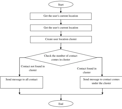
Pseudo Code for creating “User Location Cluster” and Send Message
1. On click, get the user current location
2. Get the user saved distance.
3. Create cluster and find the contacts who comes in that location cluster.
4. If no contacts in specified distance or in cluster.
Then
Send the message to all added contact out of cluster.
Else
Send the message only who comes on cluster.
Flow Chart of Pseudo Code for creating “USER_LOCATION_CLUSTER” and Send Message
Figure 2: Flowchart of creating user location cluster and sending message.
The Above flow diagram represents to send the emergency message to the user contacts. Here if the contact not
found in cluster then the message will be sent all contact, which is not added to the user location cluster.
V. CONCLUSION
Location based services comes with lot of advanced features. The proposed system used one of these features to
develop the proposed model based on geo positioning system. It will send the emergency message to all near
contact in by creating the user location cluster. The sender location will be sent to all nearest contact. This
system provide the security to user in terms of privacy to their current location also no need to worry about the
use consent while installing the app because no use of third parties API and functionalities for calculation except
trusted Google APIs.
Start
Get the user's current location
Get the user's current location
Create user location cluster
Check the number of contact comes in cluster
Send message to contact comes under the cluster Send message to all contact
Contact not found in
cluster Contact found in
cluster
REFERENCES
[1] M. Singhal and A. Shukla "Implementation of Location based Services in Android using GPS and Web
Services", IJCSI, vol. 9, no. 1, pp. 237-242, 2016.
[2] V. Zeimpekis, G. Giaglis and G. Lekakos, "A taxonomy of indoor and outdoor positioning techniques for
mobile location services", SIGecom Exch., vol. 3, no. 4, pp. 19-27, 2002
[3] M. Ginger, F. Adrian and D. Nigel, "Preserving Privacy in Environments with Location-Based
Applications", The IEEE CS and IEEE Communications Society, vol. 3, pp. 1536-1268, 2003.
[4] L. Neelu, B. Aruna Kumara, V. Shashidhar and J. Bharath, "Location Based Reminder Using Android and
Google Maps", International Journal of Innovative Research in Computer and Communication
Engineering, vol. 3, no. 5, pp. 4173-4183, 2015.
[5] M. Singhal1 and A. Shukla"Implementation of Location based Services in Android using GPS and Web
Services", IJCSI, vol. 9, no. 1, pp. 237-242, 2016.
[6] www. geoawesomeness.com , Security and privacy issues of LBS