Http://www.ijetmr.com©International Journal of Engineering Technologies and Management Research [47]
FLOOD EARLY WARNING INFORMATION SYSTEM FOR
MULTI-LOCATION BASED ANDROID
Dedi Satria *1, Syaifuddin Yana 2, Rizal Munadi 3, Saumi Syahreza 4
*1 Department of Computer Engineering, UniversitasSerambiMekkah, Provinsi Aceh, Indonesia 2 Department of Industrial Engineering, UniversitasSerambiMekkah, Provinsi Aceh, Indonesia 3 Department of Elecrical Engineering, UniversitasSyiah Kuala, Provinsi Aceh, Indonesia 4 Department of Physics, UniversitasSyiah Kuala, Provinsi Aceh, Indonesia
Abstract:
Development of flood early warning technology has grown rapidly. The technology has led to improvements in terms of communication and information technology. The use of the Internet of Things model (IOTs) has provided significant development to the development of early warning information systems. In this article is the development of a prototype model of flood monitoring information systems using Android has been designed by combining ultrasonic sensors as a water level detector, rain sensor, temperature sensor and moisture sensor. Arduino Uno Microcontroller Module used as sensor data processor, U-Blox Neo 6m GPS module as location detection and Ethernet module as sender of sensor data to station of flood early warning information system. The design of the prototype produces information on flood elevation, rain conditions, ambient temperature and soil moisture along with its location based on Google Maps interface on mobile android.
Keywords: Flood; Arduino; Internet of Things; GSM; Google Maps; Mobile Android.
Cite This Article: Dedi Satria, Syaifuddin Yana, Rizal Munadi, and Saumi Syahreza. (2018). “FLOOD EARLY WARNING INFORMATION SYSTEM FOR MULTI-LOCATION BASED ANDROID.” International Journal of Engineering Technologies and Management Research, 5(8), 47-53. DOI: https://doi.org/10.29121/ijetmr.v5.i8.2018.279.
1. Introduction
Flood early warning information system serves as part of decision-making to determine disaster management policies of the government and as a material consideration of the community in knowing the location of the disaster and prepare for flood disaster. Therefore, to curb disaster risk, the government has encouraged private institutions and private sector to develop telemetry instruments in providing disaster early warning information[1]. The use of information systems based on mobile technology are now a trend among current users such as the use of applications based on android operating systems is very high[2].
Http://www.ijetmr.com©International Journal of Engineering Technologies and Management Research [48]
the community and local government using android applications. In this article aims to present information on the development of multi-location flood early warning information system based on Android.
2. Materials and Methods
Several studies have been conducted in the research and development of early warning systems based on mobile communication and information-based technologies. It is known that communication technologies involving mobile devices and machines are growing rapidly in the industrial and global world. [3]. Previous studies that have built prototypes using GSM communication-based technology models such as flood monitoring systems and SMS-based early warning [4], [5], [6].
The study resulted in the sending of flood height data using SMS using Arduino Uno intermediate and GSM module which ended with alarm at flood information system station. Besides flood warning system, Landslide warning system has been built based on arduino microcontroller and GSM module [10]. In general the research produced an efficient way of spreading an early warning message so that it does not require human presence to be informed when the possibility of a landslide is imminent. current development of early warning information systems has led to internet of things (IoTs) technology as the direction used for disaster risk management and environmental effects [11]. The use of internet-based technology has been done some previous research such as the use of Google Map as internet-based location information such as research of vehicle tracking system in real-time based on Google Map and Arduino Uno. [12]. In this study the system sends the coordinate data onto the vehicle for the GSM module to the user in the form of location based on Google Map displayed through Browser.
In a previous study the flood information system was built using an internet of thing (IoTs) model by generating web-based information with information on water level, warning status and weather conditions [7]. The use of the internet of thing model (IoTs) applied by the information system is bridging the Arduino microcontroller as a client that detects flood data with an information system server using the W5500 Ethernet module[8]. While the next research is a flood information system with information in the form of water level and location of coordinates through the GPS module that is sent to the server via GSM data communication [9].
DOI: 10.5281/zenodo.1412222
Http://www.ijetmr.com©International Journal of Engineering Technologies and Management Research [49]
The design of system prototype is done in two stages namely design phase of flood detector system and design of flood early warning information system. In detector systems built using ultrasonic sensors, rain sensor, DHT11 sensor or humidity sensor soil temperature sensor, GPS module. The sensor component is connected to Arduino Uno microcontroller. The result of data processing from Arduino Uno microcontroller is sent to flood early warning system information server via Ethernetmodule and internet modem as seen in block diagram of flood detector system Figure 1.
Rain Sensor Arduino
Uno
GPS Module
Ethernet Module Ultrasonic
Sensor
Temperature Sensor
Moisture Sensor
Internet Modem
Flood Detector System
Figure 1: Block Flood Detector Block Diagram
In the block diagram of the flood early warning information system as shown in (Figure 2) it can be explained that data sent by the flood detector remotely will be received by the wifi modem and processed on the PC computer. Data processing is processed in the mySQL database as the system management database using the sensor data table and location coordinates. The result of the relation between the two tables is integrated with PHP programming and Google Map API so as to produce output in the form of information system of early warning that will be accessed by android application.
PC Wifi
Modem
Sensor Data dan coordinate Table
MySQL PHP
+ Google Map API
Information System
Flood Location
Based
Figure 2: Block Diagram of Flood Early Warning Information System
Http://www.ijetmr.com©International Journal of Engineering Technologies and Management Research [50]
Sending Data Water Level, Rain Condition, Temperature, Moisture and Flood Location
Coordinate
Information Flood Early Warning System
Server
Mobile Application Flood Detector
System in location 1
Flood Detector System in location 2
Flood Detector System in location n
Figure 3: System data access system early warning information flooding with android applications
3. Results and Discussions
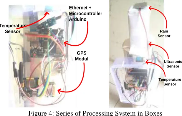
The design based on the design in (Figure 1) produces a flood detector system with sensors in the form of ultrasonic sensors, rain sensors, DHT11 sensors or temperature sensors, soil moisture sensors and GPS modules as shown in (Figure 4). The system as a whole consists of processor boxes containing temperature modules, U-Blox Neo 6m GPS module, Ethernet and Arduino Uno Microcontroller. While on the outside there is a rain sensor, ultrasonic sensors and humidity sensors.
Ethernet + Microcontroller Arduino
GPS Modul Temperature
Sensor Rain
Sensor
Ultrasonic Sensor
Temperature Sensor
Figure 4: Series of Processing System in Boxes
DOI: 10.5281/zenodo.1412222
Http://www.ijetmr.com©International Journal of Engineering Technologies and Management Research [51]
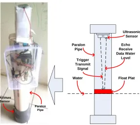
Paralon Pipe Moisture
Sensor
Ultrasonic Sensor
Float Plat Water
Paralon Pipe
Trigger Transmit
Signal
Echo Receive Data Water
Level
Figure 5: Construction of Device Detection Flood height .
Sensor data sent from the flood detection device to the flood early warning information system is stored in the mySQL database as shown in (Figure 6). In the information system database there are several fields including kode_station, water_level, weather_status, temperature, moisture_status, warning_status, lat_coordinate and lng_coordinate.
Figure 6: Database of Flood Early Warning Information System
Http://www.ijetmr.com©International Journal of Engineering Technologies and Management Research [52]
Information From Station 1
Information From Station 2
Figure 7: Android application-based information system
4. Conclusions and Recommendations
Based on the designed results, the Android based flood warning information system on the client side has been working as expected. Using ultrasonic sensors, rain sensor, soil moisture sensor, temperature sensor, Arduino Uno, u-Blox neo 6m GPS module and Ethernet module have been able to transmit flood station information data and flood location coordinates to client using android application. The flood information system stations to receive data onto the internet network of the flood detector system. With this prototype is expected to help information on the public in the form of flood information and its location.
Acknowledgements
This research is supported by the Ministry of Research and Higher Education (Ristekdikti) in the form of grant scheme for college cooperation research (PKPT). We are grateful to the Research Team from Universitas Serambi Mekkah and Universitas SyiahKuala who have provided research support in the form of laboratory facilities and technical consultation.
References
[1] R. J. M. Mercado, “Design of wireless sensor networks using embedded Programmable System-on-Chip (PSoC) as applied to community-based flood early warning systems (CBFEWS),” in
2016 International Conference on Advances in Electrical, Electronic and Systems Engineering (ICAEES), 2016, pp. 214–223.
[2] B. Kurniawan and H. Pranoto, “Information System Method Using Bandung Destinations Location Based Service (LBS) Android-Based,” J. Eng. Appl. Sci., vol. 12, no. 1, pp. 40–42, 2017.
DOI: 10.5281/zenodo.1412222
Http://www.ijetmr.com©International Journal of Engineering Technologies and Management Research [53] [4] S. Azid, B. Sharma, K. Raghuwaiya, A. Chand, S. Prasad, and A Jacquier, “SMS Based Flood Monitoring and Early Warning Systems,” ARPN J. Eng. Appl. Sci., vol. 10, no. Vol. 10, No.15, pp. 6387–6391, 2015.
[5] E. Kuantama, P. Mardjoko, and M. A. Saraswati, “Design and Construction of Early flood warning system through SMS based on SIM300C GSM modem,” Proc. 2013 3rd Int. Conf. Instrumentation, Commun. Inf. Technol., Biomed. Eng. Sci. Technol. Improv. Heal. Safety, Environ., ICICI-BME 2013, pp. 115–119, 2013.
[6] H. N. Do, M. Vo, V. Tran, P. V. Tan, and C. V. Trinh, “An Early Flood Detection System Using Mobile Networks,” 2015 Int. Conf. Adv. Technol. Commun. An, pp. 599–603, 2015.
[7] D. Satria, S. Yana, R. Munadi, and S. Syahreza, “Design of Information Monitoring System Flood Based Internet of Things ( IoT ),” in Malikussaleh International Conference on Multidisciplinary Studies (MICoMS 2017), 2018, pp. 629–639.
[8] S. S. Dewi, D. Satria, E. Yusibani, and D. Sugiyanto, “Design of Web Based Fire Warning System Using Ethernet Wiznet W5500,” in Malikussaleh International Conference on Multidisciplinary Studies (MICoMS 2017), 2018, pp. 437–442.
[9] D. Satria, S. Yana, R. Munadi, and S. Syahreza, “Prototype of Google Maps-Based Flood Monitoring System Using Arduino and GSM Module,” Int. Res. J. Eng. Technol., vol. 4, no. 10, pp. 1044–1047, 2017.
[10] C. D. Fernandez, K. J. A. Mendoza, and A. Jude, “Development of Microcontroller-based Landslide Early Warning System,” 2016 IEEE Reg. 10 Conf., pp. 3000–3005, 2016.
[11] S. Poslad, S. E. Middleton, F. Chaves, R. Tao, O. Necmioglu, and U. Bugel, “A Semantic loT Early Warning System for Natural Environment Crisis Management,” Ieee Trans. Emerg. Top. Comput., vol. 3, no. 2, pp. 246–257, 2015.
[12] M. M. Rahman, J. R. Mou, K. Tara, and M. I. Sarkar, “Real time Google map & Arduino based vehicle tracking system,” ICECTE 2016 - 2nd Int. Conf. Electr. Comput. Telecommun. Eng., no. December, pp. 8–10, 2017.
*Corresponding author.