City, University of London Institutional Repository
Citation
:
Kaparias, I. (2008). Reliable dynamic in-vehicle navigation. (Unpublished Doctoral thesis, Imperial College)This is the accepted version of the paper.
This version of the publication may differ from the final published
version.
Permanent repository link:
http://openaccess.city.ac.uk/6795/Link to published version
:
Copyright and reuse:
City Research Online aims to make research
outputs of City, University of London available to a wider audience.
Copyright and Moral Rights remain with the author(s) and/or copyright
holders. URLs from City Research Online may be freely distributed and
linked to.
City Research Online: http://openaccess.city.ac.uk/ [email protected]
Reliable Dynamic In-vehicle Navigation
Ioannis Kaparias (MEng)
A thesis submitted for the degree of Doctor of Philosophy of the University of London
and Diploma of the Membership of Imperial College London
Centre for Transport Studies
Department of Civil and Environmental Engineering
Imperial College London, London, UK
Acknowledgements
First and foremost, I would like to express my gratitude to my supervisor, Prof Michael G. H. Bell, for his essential and continuous guidance, support and encouragement throughout this PhD. Whilst giving me the freedom to develop my own ideas, he has always provided me with constructive feedback and critical reviews, aiming to improve my work as much as possible. Without his outstanding supervision this thesis would not have been possible at all.
Furthermore, I would like to thank BMW Group for sponsoring this work, and in particular the efforts and support of Dr Klaus Bogenberger and Dr Heidrun Belzner. Additionally, I would like to thank PTV AG and particularly Karsten McFarland for providing the test network used in the field experiments of this project, as well as ITIS Holdings Ltd and Ian Forshaw for supplying his-torical floating vehicle data for the field experiments.
Many thanks go to Prof Yanyan Chen from Beijing University of Technology, who particularly assisted me in the early stages of my PhD, and to Prof Hartmut Keller from TRANSVER Ltd and the other partners of the OFFENSIVE project for their valuable peer review throughout the du-ration of the project.
Further, I would like to thank my colleagues, office-mates and good friends Kyoung-A Park, Konstantinos Zavitsas and Panagiotis Angeloudis, the former two for helping me with the con-duct of the field experiments, and the latter for always being around when I needed assistance with programming matters. Many additional thanks go to them, along with Susie, Ning, Jan-Dirk and Simon, for being such great office-mates and for always keeping a pleasant and happy atmosphere in room 205. A big thank you also goes to my uncle Kimon for taking the time to proof-read my thesis and to provide me with extremely useful comments.
Declaration of contribution
At various stages during the PhD research reported here, collaboration has taken place with colleagues working on the subject. The output of this collaboration has been included in this thesis to better explain and support the research reported. In particular, the research carried out has built upon the work conducted for the OFFENSIVE project, sponsored by BMW Group, which started in January 2004 and ended in June 2007. I became a member of the project team in October 2004 and contributed to the development of the initial formulation of the new in-vehicle navigation algorithm, which is described in Chen et al (2005a) and Chen et al (2005b). This work was carried out in collaboration with Prof Yanyan Chen from Beijing Univer-sity of Technology during her stay at Imperial College London in 2004, Prof Michael G. H. Bell and Dr Klaus Bogenberger from BMW Group, and is reported and appropriately referenced in Section 4.3.1.
In addition to that, collaboration with my supervisor, Prof Michael G. H. Bell, has taken place in the work described in Section 2.4.4, which involved the mathematical proof of the optimality of the reverse A* algorithm.
I hereby declare that apart from the collaborations referred to above the work described in this thesis has been carried out by myself.
………..……….
(Ioannis Kaparias)
………..……….
Abstract
Having started off from luxury makes and models, in-vehicle navigation systems are now gradually spreading through the entire vehicle fleet, as drivers appreciate their usefulness. In-creasingly sophisticated systems are being developed, having much more advanced functions than simple driving directions. This thesis presents a new approach for in-vehicle navigation, in which travel time reliability is incorporated in the route finding component of the navigation system. Based on historical traffic data and in the absence of current traffic information, posi-tions in the road network at which it is likely to encounter delays, are predicted and avoided as much as possible by the route finding algorithm.
The thesis starts by reviewing shortest path algorithms and conjectures that the most appro-priate algorithm to use is A*, which forms a vital part of the approach developed. Performing multiple runs of A* forwards and backwards on the road network, efficiency of the route find-ing procedure is achieved. The time-dependent version of the algorithm is also derived. Then, the thesis goes on to define reliability on a single link of the road network as the maximum delay that can be encountered with 90% confidence and extends this definition to derive the reliability of entire routes.
Having introduced the route finding procedure and the concept of reliability, the thesis pre-sents the in-vehicle navigation approach, which involves computing a more reliable route from
the d i e s o igi to his/he desti atio tha the fastest, if this is u elia le. Additio all , the
par-tially disjoint routes, penalties are also applied to links that are already included in a previously computed and accepted route. The new algorithm, RDIN, is thus presented and mathemati-cally formulated. An extension to RDIN for re-routing, RDIN-R, is also developed.
Table of contents
Acknowledgements ... 1
Declaration of contribution ... 2
Abstract ... 3
Table of contents ... 5
List of figures ... 8
List of tables ... 10
1
Introduction... 11
1.1 Background ... 11
1.1.1 Benefits of in-vehicle navigation systems ... 12
1.1.2 Brief historical overview of in-vehicle navigation ... 13
1.2 Modern in-vehicle navigation systems ... 16
1.2.1 State-of-the-art ... 16
1.2.2 Usage of in-vehicle navigation systems ... 20
1.3 Objectives and outline... 23
1.3.1 Aims and objectives ... 23
1.3.2 Outline of the thesis ... 25
2
Route finding in road networks ... 27
2.1 Introduction ... 27
2.2 Background ... 28
2.2.1 Network searching techniques ... 28
2.2.2 Shortest path algorithms ... 30
2.2.3 Time-dependent shortest path algorithms ... 37
2.2.4 Summary ... 39
2.3 Modelling road network features ... 40
2.3.1 Representation of road network features ... 40
2.3.2 Turn restrictions ... 41
2.3.3 Positioning of the vehicle ... 43
2.4 The standard A* algorithm ... 45
2.4.1 The FA* algorithm ... 46
2.4.2 Optimality of the FA* algorithm ... 48
2.4.3 The RA* algorithm ... 51
2.4.4 Optimality of the RA* algorithm ... 53
2.5 Calculation of time-dependent travel times ... 54
2.5.1 Forward time-dependent travel time calculation ... 55
2.5.2 Reverse time-dependent travel time calculation... 57
2.6 Concluding remarks ... 61
3
Travel time uncertainty, variability and reliability... 63
3.1 Introduction ... 63
3.2 Literature review ... 64
3.2.1 The importance of travel time uncertainty and reliability ... 65
3.2.2 The causes and components of travel time variability ... 66
3.2.3 The distribution of travel times ... 69
3.2.4 Modelling travel time reliability ... 70
3.2.5 Existing measures of reliability ... 73
3.2.6 Calculating path travel time reliability ... 76
3.2.7 Summary ... 78
3.3 Quantifying reliability in in-vehicle navigation ... 79
3.3.1 Requirements of a new reliability measure ... 79
3.3.2 Definition of the reliability indices ... 80
3.3.3 Calculation of reliability from a distribution of speeds ... 85
3.3.4 Calculation of the path reliability indices ... 87
3.3.5 Calculation of the travel time variation logarithm from reliability ... 89
3.3.6 Time-dependent link reliability calculation ... 94
3.3.7 Numerical examples ... 97
3.4 Concluding remarks ... 104
4
Reliable dynamic in-vehicle navigation methodology ... 106
4.1 Introduction ... 106
4.2 Background ... 108
4.2.1 Routing under uncertainty ... 108
4.2.2 Multiple routes ... 111
4.2.3 Multiple objectives and constraints ... 113
4.2.4 Existing in-vehicle navigation approaches and strategies... 115
4.2.5 Summary ... 119
4.3 The reliable dynamic in-vehicle navigation (RDIN) algorithm ... 120
4.3.1 Che s li k pe alt ethod ... 120
4.3.2 Description of the RDIN algorithm ... 124
4.3.3 Formulation of the RDIN algorithm ... 132
4.4 The reliable re-routing (RDIN-R) algorithm ... 135
4.4.1 Background on re-routing algorithms ... 136
4.4.2 Description of the RDIN-R algorithm... 137
4.4.3 Formulation of the RDIN-R algorithm ... 139
4.5 Concluding remarks ... 142
5
Software implementation and simulation experiment ... 144
5.1 Introduction ... 144
5.2 Software implementation – ARIAdNE ... 145
5.2.1 Modes of operation and abilities ... 145
5.2.2 Structure ... 146
5.2.3 User interface ... 149
5.3.1 Test network ... 151
5.3.2 Link speed data ... 153
5.3.3 Junction delay data ... 155
5.3.4 Reliability data ... 158
5.4 Experimental conduct and results ... 160
5.4.1 Parameters and procedure ... 160
5.4.2 Results ... 162
5.4.3 Evaluation ... 165
5.5 Concluding remarks ... 166
6
Validation and field experiments... 167
6.1 Introduction ... 167
6.2 Data acquisition and processing ... 168
6.2.1 Background of travel time estimation and FVD ... 169
6.2.2 Test network ... 171
6.2.3 ITIS FVDTM set collection and processing ... 173
6.2.4 Simulation of missing data ... 176
6.3 Conduct of the field experiments ... 179
6.3.1 Conduct and analysis of the single-vehicle experiment ... 179
6.3.2 Conduct and analysis of the double-vehicle experiment ... 181
6.3.3 Experiment parameters ... 182
6.4 Results ... 183
6.4.1 Pre-experiment ... 183
6.4.2 Single-vehicle experiment ... 185
6.4.3 Double-vehicle experiment ... 189
6.5 Concluding remarks ... 193
7
Conclusions and recommendations for further research ... 195
7.1 Conclusions ... 195
7.2 Recommendations for further research ... 198
7.3 Practical implementation ... 200
Publications relating to this work ... 202
References ... 204
Appendix A: Distribution of speeds ... 223
Appendix B: Example of travel time distribution ... 226
Appendix C: Complete results of field experiments ... 228
C.1 Single-vehicle experiment ... 228
C.2 Double-vehicle experiment ... 232
Appendix D: Statistical significance tests ... 234
D.1 Single-vehicle experiment ... 234
List of figures
Figure 1.2-1: Embedded in-vehicle navigation unit (from BMWTM) ... 17
Figure 1.2-2: Free-standing after-market in-vehicle navigation unit (from GarminTM) ... 17
Figure 1.2-3: Modules of in-vehicle navigation systems ... 19
Figure 1.2-4: Factors affecting the satisfaction of users with navigation systems ... 21
Figure 1.2-5: Purposes of using navigation systems ... 22
Figure 2.2-1: A* algorithm ... 34
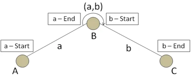
Figure 2.3-1: Representation of junction movements placing labels (framed) on the links ... 43
Figure 2.3-2: Problem of using nodes in path finding in real road networks ... 44
Figure 2.5-1: Forward time-dependent travel time calculation ... 56
Figure 2.5-2: Reverse time-dependent travel time calculation ... 58
Figure 3.2-1: Log-normal probability density function ... 69
Figure 3.3-1: The relationship between Tlog(l)and rL(l) ... 90
Figure 3.3-2: The influence of (l) on the skew of the log-normal distribution ... 91
Figure 3.3-3: The relationship between Tlog(l)and rE(l) ... 93
Figure 3.3-4: Path p, consisting of five elements ... 97
Figure 4.3- : Che s li k pe alt ethod ... 123
Figure 4.3-2: The RDIN algorithm ... 131
Figure 5.2-1: Network structure of ARIAdNE ... 147
Figure 5.2-2: ARIAdNE main menu... 149
Figure 5.2- : A‘IAdNE use i te fa e i Na igatio ode ... 150
Figure 5.2- : A‘IAdNE use i te fa e i Desig ode... 151
Figure 5.3-1: The Munich test network ... 152
Figure 5.3-3: Simulated link speed profiles for weekends ... 154
Figure 5.3-4: Simulated left turn delay profiles ... 156
Figure 5.3-5: Simulated straight-on movements delay profiles ... 157
Figure 5.3-6: Simulated earliness and lateness profiles of a reliable link ... 159
Figure 5.3-7: Earliness and lateness profiles of an unreliable link during weekday evening peaks ... 159
Figure 5.3-8: The unreliable part of the B13 during weekday afternoon peaks ... 160
Figure 5.4-1: Experiment parameters, as shown in ARIAdNE ... 161
Figure 5.4-2: The fastest route (a) and the three reliable alternative routes (b-d) ... 163
Figure 5.4-3: Re-routing on the first alternative route ... 164
Figure 6.2-1: Operation of the ITIS FVDTM system ... 169
Figure 6.2-2: ITIS FVDTM coverage in Central London ... 172
Figure 6.2-3: The test network ... 173
Figure 6.2-4: Sample extract from the supplied ITIS FVDTM file ... 174
Figure 6.2-5: The speed, earliness and lateness lists for a link ... 175
Figure 6.2-6: Simulated speed, earliness and lateness profiles ... 177
Figure 6.3-1: Configuration of the single-vehicle field experiments ... 180
Figure 6.4-1: (a) Pre-experiment travel time ratios and (b) cumulative distributions ... 185
Figure 6.4-2: Cumulative distributions... 186
Figure 6.4-3: Cumulative distributions, including UCETT/ATT ... 188
Figure 6.4-4: Avoidance of specific unreliable links by ARIAdNE ... 189
Figure 6.4-5: CATT and AATT values for each run of the experiment... 190
Figure 6.4-6: Cumulative distribution plot of DATT/CATT ... 190
Figure 6.4-7: FCATT and FAATT values for each run of the experiment ... 191
Figure 6.4-8: Cumulative distribution plot of FDATT/CATT ... 192
Figure 6.4-9: The advantage of the ARIAdNE route compared with the conventional route .. 193
List of tables
Table 3.3-1: Mean travel time and standard deviation for the five elements of path p ... 97
Table 3.3-2: Descriptive statistics for the speed and travel time distributions ... 100
Table 5.3-1: Speed limits for each road type and speed values used ... 153
Table 5.3-2: Maximum simulated delay values for left turns ... 155
Table 5.3-3: Maximum simulated delay values for straight-on movements ... 155
Table 6.4-1: Pre-experiment departure and arrival times ... 184
Table 6.4-2: Pre-experiment travel times ... 184
Table 6.4-3: Pre-experiment travel time ratios ... 184
Table 6.4-4: Mean, standard deviation and extreme values of travel time ratio distributions 186 Table A-1: Selected links and time intervals ... 223
Table A-2: Speed distributions descriptive statistics (in km/h) ... 223
Table A-3: K-S test results ... 225
Table B-1: The complete speed distribution and the resulting travel time distribution ... 226
Table B-2: Descriptive statistics of the speed and travel time distributions ... 227
Table C.1-1: Recorded departure and arrival times in the single-vehicle experiment ... 228
Table C.1-2: Recorded travel times (in minutes) and travel time ratios ... 229
Table C.1-3: Travel time ratios to ATT and corresponding cumulative probabilities ... 230
Table C.2-1: Recorded departure and arrival times in the double-vehicle experiment ... 232
CHAPTER 1
Introduction
1.1
Background
Intelligent Transport Systems (ITS) can be viewed as the integration and deployment of ad-vanced technologies in areas such as information, communication and navigation in order to achieve a more efficient and safer transportation system (Huang et al, 1995). Especially in the last decade, the field of ITS has experienced a spectacular growth with emerging technologies being increasingly implemented in transport applications. Examples range from the develop-ment of new advanced information systems for both private and public transport, to the intro-duction of cutting-edge systems in road, rail and air transport aiming to reduce or even pre-vent accidents, and to the utilisation of new technologies for the protection of the environ-ment.
mo-bile devices and applications. Sales reached 12 million units in 2006 in Europe and North Amer-ica, and forecasts predict that they will reach 53 million units by 2012 (Berg Insight, 2007a), proving thus that in-vehicle navigation is a rapidly evolving field.
This study presents a novel in-vehicle navigation methodology with the prospect of being im-plemented in a new advanced navigation system, which will consider the reliability of travel time and will thus provide the user with accurate driving directions and travel time predictions. The aims and objectives of the study are set out in Section 1.3; the current section continues with the background of in-vehicle navigation, which includes a description of the benefits of such systems and a brief historical overview of the topic, while Section 1.2 presents the state-of-the-art of the field.
1.1.1
Benefits of in-vehicle navigation systems
In-vehicle navigation systems have benefits for both their users and the whole transport sys-tem. Starting from the users, who in this case are the drivers of the vehicles equipped with navigation devices, the primary purpose and benefit of in-vehicle navigation is assistance in unfamiliar areas. In areas of the road network, of which a driver has little or no knowledge, it is very likely that, in the absence of a navigation system, he/she will have difficulty in finding a route to his/her destination and will consequently have to stop and either look at a map or ask for directions. Apart from the loss of time that such a process requires, it also has safety impli-cations, as it is possible that the driver will not find an appropriate place to stop and will end up looking at the map or even speak on his/her mobile phone whilst driving. Making use of an in-vehicle navigation system considerably eases the driver in this kind of situation.
Considering the benefits of in-vehicle navigation for the transport system, the most important one is the fact that the use of such devices reduces the overall time lost in the network and eases congestion (Jeffery, 1981). Vehicles driving around, unsuccessfully looking for the right route constitute a significant proportion of the traffic flow of a network; the use of navigation systems results in trips being shorter, thus relieving the network from a considerable traffic load. Additionally, making trips shorter and decreasing the total driving time in the network results in less pollution, so navigation systems contribute to the protection of the environment. Also, by improving the safety of individual drivers, navigation systems also increase the overall safety in the network, as they result in less dangerous driving thus reducing the probability of occurrence of traffic accidents.
Naturally, navigation systems have also been criticised as having the opposite effects to their intended ones under certain conditions, particularly with respect to safety and congestion. Regarding safety, such systems are accused of in fact causing accidents instead of preventing them, as they often require input from the driver whilst en route and thus distract him/her from driving. With respect to congestion, on the other hand, and despite the fact that naviga-tion systems generally reduce traffic volumes, they are blamed for guiding a large number of vehicles along specific routes, thus increasing traffic levels at some locations. Nevertheless, these are issues that are gradually being taken into account by manufacturers, such that their occurrence is eliminated in the development of newer systems.
1.1.2
Brief historical overview of in-vehicle navigation
Vehicle navigation has been in the spotlight of humanity for thousands of years, with the earli-est vehicle navigation system dating as back as ancient China in 2600 B.C., when the so-called
south-poi ti g a iage as i e ted. This as a t o-wheeled cart on which a human figure was mounted, whose characteristic was that it was always pointing to the South, no matter which way the cart was moving. The south-pointing human figure was maintained in position through the action of a gear train (Zhao, 1997).
The ERGS (Electronic Route Guidance System) was a system developed in the 1960s by the US Federal Highway Association, aiming to provide route guidance to vehicles (Rosen et al, 1970). Its components consisted of in-vehicle units, enabling the interaction of the system with the driver, and roadside proximity beacons with roadside controllers placed at intersections, used for two-way communication with the in-vehicle units. The concept of the s ste s operation was as follows: the driver entered the destination of his/her trip which was transmitted to the roadside beacon and controller each time the vehicle approached an intersection. The road-side controller on the other road-side computed the direction to the destination and transmitted, through the beacon, the requested driving manoeuvre to the in-vehicle unit. The controller was also connected to a centralised host for accessing traffic data.
In the 1970s a similar system was developed in Japan. The CACS (Comprehensive Automobile Traffic Control System) project, started in 1973 and completed in 1979, was presented as a communication system that links vehicles in motion, roadside equipment and a central data
p o essi g o e (Totani, 1980). The system offered three functions, namely dynamic route guidance, emergency radio and driving information. Not only was this a significant improve-ment to ERGS in terms of the route guidance function (it was based on real-time data derived from measured travel times collected from vehicles equipped with the system), but also two entirely new functions were offered. The result of a field test that was carried out showed that guided vehicles benefited from significant travel time savings; nonetheless, a problem that was dis o e ed as that he the ehi le s speed as highe than 100 km/h there was not enough time for data exchange between the roadside unit and the in-vehicle unit.
data measured and used in the calculation of the routes was also complemented by inductive loop data.
The introduction of satellite positioning in the 1990s gave a new dimension to in-vehicle navi-gation, as systems did not have to rely entirely on ground infrastructure anymore. Examples of experimental systems using the Global Positioning System (GPS) in order to identify their loca-tion include ADVANCE and TravTek in the US, and Travelguide in Canada. Starting from AD-VANCE (Boyce et al, 1991; Boyce et al, 1993; Saricks et al, 1997), this was experimentally launched in 1991 by a consortium of public sector, academic and industrial partners in the area of Chicago, Illinois. The system consisted of in-vehicle units, which used GPS, dead reckoning (i.e. extrapolating the current position based upon a previously determined position, known speed, elapsed time and course) and map-matching (i.e. matching a set of geographical co-ordinates on a road map) techniques for establishing their locations, while map data was stored in an on-board CD-ROM. Ground infrastructure on the other hand was limited to the existence of the Traffic Information Centre (TIC), which was in continuous contact with the in-vehicle units through a two-way data exchange procedure. Vehicle units transmitted travel time measurements to the TIC through a dedicated radio frequency, and received traffic in-formation from it, which they used in the route computations they offered to the drivers. While a large-scale field test with 5000 test vehicles was planned, only a small-scale deploy-ment took place with 80 test vehicles.
The advances in the satellite positioning field in the 1990s resulted in affordable GPS receivers becoming available, which gave particular boost to the development of so- alled auto o ous in-vehicle navigation systems (as opposed to e t alised s ste s des i ed a o e , i.e. sys-tems not depending on the communication and data exchange with a traffic manage-ment/information centre and having all the information they require pre-loaded and stored on board the vehicle unit. Before satellite positioning became available, very few autonomous systems had been developed. Examples include ARCS (Automatic Route Control System) (French and Lang, 1973), which was the first basic autonomous navigation system developed and was using dead reckoning for positioning whilst driving on pre-determined routes, and CARIN (Car Information and Navigation) in the 1980s, which also used dead reckoning for posi-tioning but was innovative because it was the first system to use an on-board CD-ROM for map storage (Zhao, 1997). Particularly in the last decade more autonomous navigation systems have appeared in the market; the development of new centralised systems on the other hand has decreased and the functions previously offered by such services (e.g. real-time traffic in-formation) are now usually offered as extras on basic autonomous systems. The state-of-the-art of the in-vehicle navigation field is described in the next section.
1.2
Modern in-vehicle navigation systems
Starting from the forms in which modern navigation systems are available, this section goes on to describe the state-of-the-art of car navigation and the individual modules of which a mod-ern navigation device consists. Then, following market research published in the literature, the evaluation of current systems by drivers is presented and their needs are identified.
1.2.1
State-of-the-art
equipment, while the latter refer to after-market devices purchased and installed in the vehi-cle from independent suppliers.
Figure 1.2-1: Embedded in-vehicle navigation unit (from BMWTM)
Figure 1.2-2: Free-standing after-market in-vehicle navigation unit (from GarminTM)
There are seven different types of in-vehicle navigation devices, according to Wood et al (2006):
Dedicated units integrated into the vehicle by the OEM (see Figure 1.2-1)
In-vehicle entertainment devices with navigation installed as an accessory or replace-ment of a conventional function (e.g. radio, CD, tape)
Dedicated after-market devices permanently installed in the vehicle
Personal digital assistants (PDAs) with suitable software and connection to a GPS re-ceiver
Mobile phones
Mobile data terminals
Also, systems are classified as either on-board or off-board (i.e. autonomous or centralised); in the former, the map data, routing software and GPS receiver are all in the vehicle, while in the latter, the vehicle is only equipped with a GPS receiver and the remaining entities are located on a central server. In a different classification by Berg Insight (2005), in-vehicle navigation consists of three segments: stand-alone navigation, PDA navigation and smartphone (i.e. ad-vanced mobile phone) navigation. Especially the last two are increasingly gaining in popularity, as the current trend is towards the integration of navigation systems with other units (Wood et al, 2006). As an example, sales of navigation software for smartphones reached 0.6 million in Europe and North America in 2006, and it is estimated that by 2012 there will be 43 million mobile phone navigation users in those regions (Berg Insight, 2007b).
From the variety of available navigation systems and devices able to support personal naviga-tion software, it can be seen that the in-vehicle naviganaviga-tion market is very competitive. In order to keep up with the growing competition, developers and suppliers of devices, software and services endeavour to improve their products as much as possible. Hence, systems containing increasingly more sophisticated functions than simple driving directions have been and are still being developed. These range from more advanced algorithms aiming to calculate better routes (i.e. more attractive to the driver, such as fastest route, shortest route, avoiding tolls, preferring motorways etc.) making use of higher quality data (e.g. real-time dynamic travel times rather than static data), to enhanced communication abilities involving real-time traffic information aiming to inform the driver on congested areas in the road network, and even to extra features not directly relevant to navigation, such as weather information, Bluetooth con-nectivity and media player. Features expected to be included in future navigation systems in-clude automatic speech recognition, 3D map features, photo-realistic textures, multi-function capabilities and wireless internet connectivity (Berg Insight, 2007a).
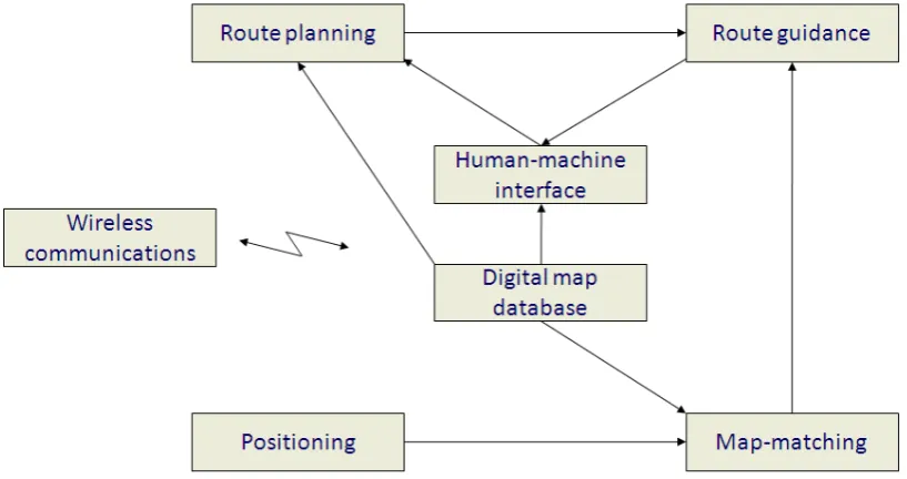
in-tended to carry out a set of particular functions, as shown in Figure 1.2-3. These are: the digital map database module, the positioning module, the map-matching module, the route planning module, the route guidance module, the wireless communications module and the human-machine interface module.
[image:21.595.123.532.426.642.2]The digital map database module holds digitised map information such as locations, road ge-ometry, road classifications and traffic regulations with respect to the geographical co-ordinate system, while the positioning module fuses different sensor outputs and radio signals for the determination of the position of the vehicle. Sensors employed mainly include a GPS receiver, which establishes the geographical co-ordinates of the device, though in embedded systems this can also be complemented by a magnetic compass and an odometer for dead-reckoning. Blending the outputs of these two modules together, the map-matching module is responsible for associating the position measured by the positioning module with a location in the digital map database module, since errors in satellite positioning can be fairly significant (Ochieng et al, 2004; Quddus et al, 2007).
Figure 1.2-3: Modules of in-vehicle navigation systems
(Zhao, 1997)
the wireless communications module, whose aim is to transmit real-time traffic information to the system. The route guidance module on the other hand is responsible for guiding the driver to his/her destination according to the output of the route planning module and based on po-sitioning by the map-matching and digital map database modules. Finally, the human-machine interface module enables the interaction between the driver and the system, transmitting the requests of the former to the latter and displaying its output to him/her.
The present study focuses on the route planning module and a further description of all other modules extends beyond its scope. The state-of-the-art in the route planning module, as re-ported in the study by Wood et al (2006), includes features such as multi-routing and link im-pedance. Multi-routing is applied whenever the market penetration level of a system is high, resulting in reduced travel time savings, due to the simultaneous use of the same routes by the vehicles; link impedance on the other hand is implemented whenever particular roads (or road classes) need to be avoided (e.g. to discourage systems from recommending shortcuts through residential areas). Both these techniques are employed later in the present study.
Before stating the aims and objectives of this work in the next section, the next sub-section reports on the status of navigation systems in terms of usage and user satisfaction, as this ba-sically reflects the motivation behind it.
1.2.2
Usage of in-vehicle navigation systems
The fact that in-vehicle navigation systems are rapidly spreading through the vehicle fleet in Europe and North America was reported in the previous sub-section. Nonetheless, in order to identify the requirements for a new navigation system, one needs to look into the usage and evaluation of existing navigation systems from the viewpoint of the drivers. Several market research studies have been conducted and continue to be carried out, aiming to reflect the
d i e s eeds f o a a igatio de i e.
that their own route-pla i g is ette tha the s ste s (Schofer et al, 1997). It is hence not surprising that, as shown by Svahn (2004), navigation systems are used mostly in environments which are unfamiliar to the driver, and in particular by drivers with a high annual mileage (e.g. taxi drivers, professional van drivers etc.).
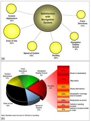
Figure 1.2-4: Factors affecting the satisfaction of users with navigation systems (J.D.Power and Associates, 2006)
The ost ota le stud o a igatio s ste s usage, ho e e , is the a ual Na igatio u
2006).
[image:24.595.182.474.321.517.2]The study identified that routing is the second most important factor affecting user satisfaction with navigation systems, stated by 22% of the respondents, after ease of use, which was stated by 33% of the respondents (Figure 1.2-4a). Also, it was found that, among the respondents who consider routing as the most important aspect of their system, the majority (21%) value finding a correct route, with no erroneous driving directions, to their chosen destination most; nevertheless, computing route alternatives (15%) and correctly estimating the arrival time at the destination (12%) are also important features affecting the user satisfaction with naviga-tion devices (Figure 1.2-4b).
Figure 1.2-5: Purposes of using navigation systems
(J.D.Power and Associates, 2006)
the accuracy of the estimated time of arrival. This is the motivation behind the research work reported here; its aims and objectives are described in the next section.
1.3
Objectives and outline
It was mentioned in the previous section that users would like to see more advanced features in the routing function of their navigation systems, so that they can obtain more accurate driv-ing directions and travel time estimates, and also avoid congested areas. Incorporatdriv-ing real-time data as a standard feature (currently a premium service) in navigation systems would go some way to solve the problem; however, real-time data is collected, processed and distrib-uted to vehicles by dedicated private companies, and including it as a standard feature in navi-gation systems would significantly increase their price, something drivers are rather reluctant to consider, according to J.D. Power and Associates (2006). Hence, a method to address the
d i e s eeds f o a a igatio s ste using historical traffic data and only minimal real-time information (incident and road works reports as broadcast on the radio) should be sought.
The aims and objectives of this study are presented first, followed by an outline of the individ-ual chapters.
1.3.1
Aims and objectives
Additionally, on-board devices have limited computing power (300-600 MHz) and need to sup-port, apart from the route guidance function, a series of additional functions such as visual in-terface and positioning. Although algorithms are subsequently optimised as much as possible to minimise their computational requirements (e.g. using lower-level programming languages, such as assembly or binary code) for their implementation in on-board devices, computational efficiency (i.e. minimisation of the computation time) is an issue that needs to be considered early in the development of a new in-vehicle navigation algorithm. After all, prior to their im-plementation in a new navigation system, algorithms are thoroughly tested on conventional computers, and as using low-level programming is not an option due to coding complexity and intractability issues, computational efficiency can only be achieved through the choice and ad-aptation of the algorithms themselves (or through the use of supercomputers, though this is a highly costly solution). It is thus an additional aim of this work to ensure that the new in-vehicle navigation algorithm is as computationally efficient as possible.
The objectives of the study are:
to identify a suitable route finding algorithm from a comprehensive literature review of the topic. As the route finding algorithm is a routine that needs to be called fairly frequently and hence be run several times is an on-board navigation device, it needs to be ensured that it is computationally efficient, while at the same being precise (out-putting results, that are either optimal, or at least near-optimal). The fact that travel time in a road network is not constant but varies according to the time of the day and day of the week needs to be considered, so that the algo ith s a u a is ot o m-promised. Also, the resulting time-dependent (dynamic) algorithm should be modified accordingly, so as to be applicable on road networks containing features such as turn restrictions and dead-ends.
to incorporate the previous two theoretical approaches into a single implementation framework, such that a new reliable dynamic in-vehicle navigation algorithm is formu-lated, which will use the route finding algorithm to compute route(s) for the user whilst at the same time avoiding potentially congested areas, as identified by the reli-ability measure. Also, a number of constraints are to be introduced to the optimisation problem that is formulated, so as to ensure acceptability of the route suggestions by the driver. The new algorithm is to be supported by a literature review of previously developed in-vehicle navigation strategies.
to develop an algorithm for re-routing, based on the same concept, for the case where real-time traffic information on incidents and road works is available and the driver needs to alter his/her itinerary to avoid reported congestion, or for the case where the driver accidentally misses a driving direction.
to implement the newly derived methodology so that it can be tested and evaluated. A software tool containing the algorithm and also providing a user interface similar to that of an actual navigation system needs to be developed.
to validate the new approach through a set of specially designed experiments. Apart from an initial simulation experiment that needs to be carried out to test the new software tool and to draw some preliminary conclusions, the new algorithm is to be tested in the field, i.e. in a real-world situation using real data. The results from the new method need to be compared with the output from an existing navigation system in order to demonstrate its potential superiority.
1.3.2
Outline of the thesis
The present study consists of seven chapters, structured so as to reflect the research objec-tives listed in the previous section. Each chapter consists of different sections and sub-sections, beginning with a short introduction and ending with some concluding remarks.
Chapter 2 deals with route finding in road networks and starts with a comprehensive literature review of the topics of static and time-dependent path finding. Then, a description of the ad-aptations made to path finding algorithms with respect to their application on road networks is given; this is followed by a formulation of the chosen route finding algorithm and the modifica-tions made to it so as to maximise its efficiency, and by a presentation of the procedure devel-oped to account for the time-dependent nature of travel time.
Chapter 3 is concerned with travel time uncertainty, variability and reliability, and begins with a review of these topics, including an account of existing measures of travel time reliability. A presentation of a new reliability measure, specifically developed for in-vehicle navigation, is then given, consisting of its basic definition for road segments (links), its extension for routes and its adaptation for the intended implementation.
Based on the definitions and measures presented in Chapters 2 and 3, Chapter 4 introduces the new complete reliable dynamic in-vehicle navigation methodology. Starting from a review of previous relevant research, two new algorithms are presented and mathematically formu-lated: the first algorithm is for pre-trip planning, where route guidance is sought prior to leav-ing the origin, whereas the second is intended for plannleav-ing whilst en-route, in the case where re-routing needs to take place.
Chapter 5 presents the implementation of the algorithms described in Chapter 4 and intro-duces a new software tool developed for this purpose. The functions and user interface of the program are described. A simulation experiment carried out using the new software tool is presented next, including descriptions of the data simulation and experimental procedures, and an account of the results obtained is given. The simulation experiment constitutes pre-liminary testing of the new methodology.
Chapter 6 reports on the validation of the new approach through two field experiments carried out in Central London using floating vehicle data. The report includes descriptions of the acqui-sition and processing of the data required, and of the experimental procedure, as well as the presentation and discussion of the results obtained from both experiments.
CHAPTER 2
Route finding in road networks
2.1
Introduction
Path finding (or route finding) is an essential part of an in-vehicle navigation system, as finding a route between two points in the road network is a function that may be called several times during the operation of the system. The range of routing requests in a navigation system is very broad; from simple requests for driving directions from an origin to a destination input by the driver, to advanced retime routing according to multiple objectives and constraints, al-ternative routes and re-routing in more sophisticated systems.
Though a fairly large number of methods for finding routes through a network have been de-veloped, only few can be used in dynamic navigation, because there are operational require-ments (see Section 1.3.1) arising from the fact that routes have to be computed in real-time and have to be supplied to the driver in as little time as possible. The suitability of a method depends both on the computational ability of the navigation device and the efficiency of the algorithm itself, which means that an efficient path finding algorithm is needed. Also, the in-corporation of time-dependence, i.e. the consideration of the fact that travel time is not stant on all roads of the road network but varies with time, is a feature that needs to be con-sidered.
The chapter is structured as follows; Section 2.2 gives a comprehensive literature review of route finding algorithms, covering the topics of network searching techniques, shortest path algorithms and time-dependent route finding algorithms. Following that, Section 2.3 describes some characteristics of real road networks and presents methods of dealing with these when applying route finding algorithms on them. Then, the A* shortest path algorithm, which is the one used in this study, is formulated in Section 2.4, followed by a description of a methodology aiming to incorporate time-dependence into it, in Section 2.5.
2.2
Background
This section reviews previous work on route finding. Initially a review of searching techniques is given, including the most widely-used shortest (and fastest) path algorithms, as well as their adaptations by different researchers. Then, the problem of path finding in networks, in which road travel times are not constant but vary over time is tackled and algorithms developed for its solution are presented.
2.2.1
Network searching techniques
respectively in transport networks), it is possible to apply any route search method and to form a search tree, starting from a given origin and aiming at a destination. Many algorithms seeking solutions have been developed and can be characterised according to their results as optimal, if they are guaranteed to find the optimal path in the network with respect to the cri-terion to be optimised (see Section 2.2.2), or heuristic, if they are guaranteed to find any path provided one exists.
The most basic step of each search algorithm is node expansion, which indicates that each node selected for exploration has all of its successors generated before the next one is se-lected. Namely, as reported in many textbooks such as the ones by Pearl (1984), Ahuja and Magnanti (1993) and Russell and Norvig (2003), path finding algorithms can be grouped in three broad categories, according to the order in which nodes are expanded: depth-first search, breadth-first search and best-first search.
In depth-first search, priority is given to the nodes located at deeper levels of the search tree. Thus, after each expansion one of the newly generated children nodes is selected and this pro-cedure is pursued until for some reason, progress is blocked. This could be either a so-called
depth- ou d , i.e. a stoppi g ule that, he t igge ed, etu s the algo ith s atte tio to the deepest alternative not exceeding the bound, or a node recognised as a dead-end. In that
ase, the algo ith a kt a ks to the ost e e t ode it had not finished exploring. While this is a simple strategy, it is usually not preferred because it can be highly inefficient. As the method is not guaranteed to find the optimal path, it is characterised as heuristic.
(see Section 2.2.2).
Both depth-first search and breadth-first search are uninformed strategies, meaning that no additional information about states beyond that provided in the problem definition is available for them to use. Best-first search on the other hand is an informed strategy, which means that
it k o s hethe e pa di g a pa ti ula ode is o e p o isi g tha a othe ased o a so
-alled e aluatio fu ctio , esulti g f o p o le -specific knowledge beyond the definition of the problem itself. Best-first algorithms are not only optimal, but also more efficient (Russell and Norvig, 2003).
The next section reviews algorithms offering solutions to a special problem of route finding, which is the shortest (or fastest) path problem. Optimal algorithms, as well as heuristic adapta-tions performed by several researchers, are presented.
2.2.2
Shortest path algorithms
The problem of finding the shortest route in a network is of vital importance for a large num-ber of applications (Ahuja et al, 1993). Initially the objective of new solution algorithms was to be able to compute the shortest route optimally; nonetheless it became clear that, since their computation time tends to significantly deteriorate with increasing network size, algorithms also need to be efficient, even if they are not optimal, and provide good heuristic solutions instead. In transport engineering, and more specifically in dynamic navigation, finding the shortest path is a subroutine that needs to be called very often. Due to the fact that the size of transport networks is usually large, it is of vital importance to have a shortest path algorithm, which is efficient enough to meet the real-time operational requirements. Therefore, a consid-erable amount of research has been devoted to incorporating various acceleration methods for standard shortest path algorithms.
path are used interchangeably in the rest of the study.
The shortest path problem can be divided into four sub-problems. Namely, the so- alled o e -to-o e sho test path problem involves finding the shortest route between a single origin and a single destination in a network. In accordance with that, the so- alled all-to-all sho test path problem consists of finding all shortest routes between all origins and all destinations in a net-work. Equivalently defined, the so- alled o e-to-all sho test path p o le is a out fi di g the shortest routes from one node to all other nodes in a network, while the so- alled all-to-o e refers to finding the shortest routes from all nodes to a single destination.
Several comparative studies of shortest path algorithms have been carried out (Dreyfus, 1969; Kelton and Law, 1978; Boffey, 1984; Ahuja et al, 1993; Salim, 1997; Zhan and Noon, 1998; Banerjee and Sidhu, 2002; Fu et al, 2006). In particular according to the study by Fu et al (2006), most algorithms follow a standard recursive decision making procedure, consisting of an ini-tialisation step, a node selection step, a node expansion step and a termination step, and only differ from each other in the node selection step, i.e. in the order in which they expand nodes until the destination is reached. In the remainder of this section the standard algorithms for the shortest path problem are presented.
Dijkstra’s algorith
Dijkst a s algorithm, concurrently developed by several researchers such as Dantzig (1960) but formulated and ultimately attributed to the Dutch mathematician E. W. Dijkstra (1959), is the most well-known shortest path algorithm. The procedure followed includes making locally op-timal choices at each step (i.e. choosing the node with the lowest cost from the origin) to pro-duce a globally optimal solution, finding the shortest route from the origin node to every other node in the network and thus solving the one-to-all shortest path problem.
The algorithm is optimal and can be categorised as uniform-cost search (see Section 2.2.1).
optimal solution to the one-to-one shortest path problem.
The main advantages of Dijkst a s algo ith ei g precision and tractability, its main overhead is inefficiency, and more specifically the size of the search space it needs to explore for the one-to-one shortest path problem. Many unnecessary nodes need to be expanded, making the
algo ith s u i g ti e e t e el lo g a d the efo e, u suita le fo i -vehicle navigation applications. Bucket implementations of Dijkstras algo ith , ho e e , p o e to e elati el faster (Cherkassky et al, 1994; Zhan and Noon, 1998). These include intermediate sorting of the nodes according to their label in order to determine which node to expand next. Bi-directional implementation is a othe a of a ele atio of Dijkst a s algo ith (see corre-sponding sub-section).
Bellman-Ford algorithm
A p ede esso of Dijkst a s algo ith a d thus a o e ge e alised e sio of it is the Bell a -Ford algorithm (Bellman, 1958; -Ford and Fulkerson, 1962). The procedure followed is similar to
Dijkst a s p o edu e, ut i stead of hoosi g the ode ith the lo est ost f o the o igi to
expand next, the algorithm expands all children nodes generated at each step and terminates only when all nodes of the network have been expanded.
The Bellman-Ford algorithm is often characterised as a dynamic programming approach of breadth-first search and is a label-correcting algorithm, meaning that nodes can be re-visited at later stages of the search, and that the shortest path to each node can only be found after termination. As a consequence, it is suitable for the one-to-all shortest path problem but not for the one-to-one shortest path problem. Because it needs to expand a larger number of nodes, it has similar ineffi ie ies i appli atio s as Dijkst a s algo ith a d a the efo e ot be used in in-vehicle navigation.
Floyd’s algorith
con-cept that the shortest path between two nodesaandbis either a direct link between them, or a route through a thirdnodec; if it is the latter, the shortest path fromatocis either a direct link or a route through anothernodedet . The algo ith s output is t o at i es, o e
of which contains the shortest path distances between all nodes of the network, while the other indicates which node lies on the path between two nodes, so that the path can be traced.
Though the algorithm performs quite well and has fairly low computation times considering the fact that it solves the all-to-all shortest path problem, it is inefficient when only a solution to the one-to-one problem is sought due to the fact that it solves a much larger problem than needed. Additionally, it has been proven that for sparse networks, i.e. networks whose num-ber of actual links is significantly lower than the numnum-ber of possible links based on the numnum-ber of nodes, applying a repeated application of a one-to-all shortest path algorithm is more effi-cient than applying an all pairs shortest path algorithm (Kelton and Law, 1978). As transport networks are considered to be sparse and for in-vehicle navigation only a one-to-one shortest
path is eeded, Flo d s algo ithm is not appropriate.
A* algorithm
Using heuristics is an effective way of reducing computation time and a common way of achieving this is by reducing the search area. The most popular heuristic search algorithm is the A* (pronounced A-star) algorithm (Hart et al, 1968) and the procedure it follows is very
si ila to Dijkst a s algo ith , the o l difference being that the A* uses a heuristic function to estimate the distance from any point to the destination node of the network; this is usually the airline distance (Euclidian distance) to the destination (or, in the case of in-vehicle navigation, the travel time corresponding to that distance). The algorithm is optimal under the condition that the heuristic estimating function is admissible, i.e. does not overestimate the actual
dis-ta e to the desti atio . A* s a ilit to o e t a u i fo ed sea h to a i fo ed o e e-sults in less nodes being expanded and thus better efficiency.
n, the evaluation functionf
(
n)
= g(
n) +
h(
n)
is calculated, whereg(
n)
is the least distance so far from the origin to nodenandh(
n)
isa heuristic estimate of the distance from nodento the destination. The node to be expanded ateach step is the node with the lowestf(
n)
value, among the nodes in the open list (see Figure 2.2-1). As the A* algorithmisthe one used in this study, a more detailed description is given in Section 2.4.Figure 2.2-1: A* algorithm
Despite outperforming traditional shortest path algorithms while at the same time being opti-mal, the A* can still sometimes become very inefficient with increasing problem dimensions.
The i p o e e t of A* s effi ie has ee the o je ti e of a esea h studies; so e
look into using more accurate heuristic estimates than the Euclidian distance (i.e. closer to the actual distance), while others attempt to modify the search procedure.
standard A* search with a new lower-bounding technique based on landmarks and the triangle inequality, thus achieving better heuristic estimates and reducing the number of nodes ex-panded. The disadvantage of those methods however is the fact that a larger amount of data needs to be provided, which is often difficult to obtain.
Other research work on the A* algorithm is presented by Korf (1985), ho p ese ts the Ite
a-ti e Deepe i g A* , follo i g a depth-first search procedure but cutting-off the respective branch, when the total g
(
n)
+ h(
n)
value exceeds a certain threshold, and claiming that not only it is optimal when h(
n)
is admissible, but also that it is simpler to implement, as there is no need of open and closed lists; its drawback, nonetheless, is the need of re-visiting previ-ously visited nodes. Pohl (1971) describes a bi-directional version of the A* (see next sub-section), though not with very promising results. Finally, Wichmann (2004) uses the A* for route finding on digital terrains, applies penalties for high gradients and improves theper-fo a e of the algo ith su -sa pli g , i.e. splitting the terrain into smaller pieces, however at the cost of precision. It can be thus concluded that for in-vehicle navigation appli-cations, the traditional form of the A* algorithm is most suitable.
Bi-directional algorithms
Another method of heuristic search is to decompose the problem into smaller problems, and bi-directional search is the commonest way of achieving this. Namely, it is conjectured by many researchers that starting two search trees from the origin and the destination simulta-neously should result in the two trees meeting halfway through the search space, thus reduc-ing the total number of nodes expanded and achievreduc-ing lower computation times.
The idea is first suggested by Nicholson (1966), who implements a bi-directional version of
Dijkst a s algo ith , outputti g so e p o isi g esults, as the algo ith is oth efficient and optimal. However, as is later identified by Dreyfus (1969), an important factor influencing the efficiency of a bi-directional algorithm is its stopping criterion, and the criterion used in
Nichol-so s algo ith akes it i fe io to u i-directional algorithms. In a bi-directional implementa-tion of the A* algorithm (Pohl, 1971), this finding is further enhanced, as it is shown that the two search trees seldom meet at the middle of the search space and grow on to become large uni-directional search trees. The study compares the two trees as two missiles passing each
h-nique, where the objective of the two trees is to find each other, rather than to find the ori-gin/destination. An implementation of this is reported in a study by de Champeaux and Sint (1977), as well as in a later study by de Champeaux (1983).
Despite the potential advantages that bi-directional algorithms may exhibit in terms of compu-tation time, this type of search is not suitable for in-vehicle navigation applications, because it cannot be extended to solve the shortest path problem under time-dependence (see Section 2.2.3).
Hierarchical algorithms
A technique to accelerate shortest path algorithms is to reduce the number of searched links; this can be done by implementing a hierarchical model and dividing up the network into dif-ferent sub-networks, and thus determine which links are more likely to be close to the shortest
path a d a e the efo e o e o th e plo i g. The a ious algo ith s that a e epo ted i
different studies are concerned with reducing the computation time as much as possible. As identified by Fu et al (2006), the efficiency of hierarchical search algorithms depends on how a real road network is cast into a hierarchical framework (i.e. how many layers are used etc), and on how to control the search transition between layers (i.e. when to stay on a level and when to move to the next one).
In a study by Liu (1997), a hierarchical search algorithm is presented, where the network is split into two layers, one containing the major road network and the other consisting of smaller sub-networks of minor links. While the algorithm takes into account network features such as dead-ends, shortcuts and underpasses, and appends the appropriate links to the correspond-ing network level, it is based on the assumption that drivers prefer travellcorrespond-ing on major roads, which is not necessarily true. The results obtained in terms of computation times are encour-aging, though the solutions are not optimal any more.
Jagade-esh et al (2002) combine hierarchical search and network pruning, so as to further improve efficiency with what they call an a epta le loss of precision. Finally, Holzer (2003) makes use of hierarchical decomposition and pre-computed information to develop and analyse a
speed-up te h i ue fo sho test path algorithms.
Though hierarchical search algorithms exhibit greater efficiency than others, their main draw-back is the fact that the routes computed are almost guaranteed that they will not be optimal, as it may be possible that the fastest route will be completely missed by the algorithm, which will output a much longer route instead, simply preferring main roads. This may particularly be a problem in areas, where no main roads are present close to the origin and destination.
Other approaches and accelerating techniques
Another approach aiming to efficiently compute the shortest route is branch-pruning. In branch-pruning, an attempt to reduce the search area of an algorithm to a smaller window, in which only links more likely to be located on the shortest path due to their location and direc-tion are contained, is made (Karimi, 1996); the result is that the heuristic algorithm used turns out to be fairly efficient, though not optimal. A similar technique is implemented by Quek and Srikanthan (2002), where offline pre-processing and pruning of the network is carried out.
Some research has attempted to improve the speed of the shortest path computation by ap-plying accelerating measures to existing algorithms. An example of this is the work of Habbal et al (1994) and of Ziliaskopoulos et al (1997), who report on an implementation of shortest path algorithms on parallel computer architectures. These techniques cannot be used for in-vehicle navigation algorithms though, as parallel computer architectures cannot be practically realised in on-board units.
2.2.3
Time-dependent shortest path algorithms
by a series of values, each corresponding to a different time interval of a day, and where dif-ferent departure times result in difdif-ferent travel times experienced. The problem has been ex-tensively studied in the past, not only in the context of transport engineering, but also in the context of communication systems.
Early work on the time-dependent shortest path problem is reported by Cooke and Halsey (1966), who present an adaptation of the Bellman-Ford algorithm, and by Dreyfus (1969), who
e te ds that ethod to Dijkst a s algo ith . Mo e e e tl , O da a d ‘o (1990) present a theoretical study describing algorithms for solving the problem, while in a study by Zilias-kopoulos and Mahmassani (1993) the computation of shortest routes for all possible departure times whilst representing the label of a node by a vector instead of a single scalar, as is the case in static networks, is suggested. A different approach, adopted by Kim and Jung (2002), is to repeatedly apply a static shortest path algorithm over a certain number of time intervals, in order to account for changes in the link travel times; at the same time, it is attempted to re-duce the computation time for subsequent searches by making use of the computed initial shortest path and only changing the elements of the path, whose weights have changed.
In a study by Horn (2000) it is proven that consistency is implied if the following assumptions hold: 1) the network is invariant, 2) the lengths and travel speeds of the links are real values
a d g eate tha ze o, t a elli g o u s as fast as the li ks ha a te isti s topology, speed limit) permit and 4) speed is the same for all parts of a link. Assuming a so- alled o sta t a
c-ele atio egi e , i.e. that i a spe ifi ti e i te al li k speed i eases/de eases li ea l ,
the study presents a methodology of incorporating time-dependence into various one-to-one and one-to-all sho test path algo ith s, i ludi g Dijkst a s a d A*, a d epo ts o the esults obtained from their comparison. The comparison is performed over a period of 12 hours (12am to 12pm) and four time intervals are defined, reflecting peak and off-peak times.
Following a similar concept, the most important contribution to the field of time-dependent shortest path algorithms is a study by Sung et al (2000), whose so- alled flo speed odel (FSM) is an efficient method of ensuring consistency in a time-dependent forecasting model and finding the shortest route in any time-depe de t et o k. The ai idea ehi d “u g s FSM is that, while travel time intervals may result in discontinuities in the link travel time dis-tribution, causing consistency to be violated in the model, speed intervals do not affect the corresponding link speed distribution. Basically, an abrupt increase in link speed results in all vehicles on the link accelerating. A change in the speed of a link results in different vehicles experiencing different travel times on the link, according to their location at the time of the change; this is not taken into consideration in any of the previous approaches and is the main advantage of the FSM compa ed to the . “u g s F“M is the ethod adopted to reflect time-dependence in this study, and is described in more detail in Section 2.5.
Other work on the time-dependent shortest path problem includes research on the so-called
stochastic time-dependent least-time path p o le ; ho e e , as this also o e s the topi of path finding under uncertainty, it is reviewed in Chapter 4.
2.2.4
Summary
Having reviewed the topics of static and time-dependent path finding, the following remarks can be made:
optimal, but are also more efficient.
Though many algorithms (and modifications thereof) exist for finding the shortest path in a network and many techniques for improving their efficiency have been developed, the most suitable algorithm for in-vehicle navigation applications is the standard A* al-gorithm, using the Euclidian distance as the most admissible heuristic, as it is both pre-cise and efficient for processors of navigation devices (see Section 1.3.1).
When searching for the shortest route in a time-dependent network, standard static shortest path algorithms can be used and guaranteed to be optimal, provided that consistency holds. From a large number of methods existing in the literature, the most suitable to be used in in- ehi le a igatio appli atio s is “u g s flo speed odel.
2.3
Modelling road network features
The traditional algorithmic structure used by label-setting or label-correcting path finding algo-rithms (such as the A* algorithm) on artificial grid networks is the one of a directed or undi-rected graph. The network consists of nodes and links, an origin and a destination node are specified and the implemented algorithm proceeds by setting or altering labels, placed on each node. Nevertheless, when attempting to implement such algorithms on real road networks for the purpose of in-vehicle navigation, this structure creates problems, mainly with respect to three issues: representation of network features, representation of turn restrictions, and posi-tioning of the vehicle in the network. Therefore, modifications to this structure are made in this study in order to convert it to a form which reflects these features. The approaches devel-oped in order to account for the above issues are described in the next sections.