Page 5 www.ijiras.com | Email: [email protected]
Mobile Anchor-Based Localization Using PSO and Path Planning
Algorithm In Wireless Sensor Networks
P. Sangeetha
M.Phil Research Scholar,
PG & Research Dept. of Computer Science, Gobi Arts & Science College (Autonomous),
Gobichettipalayam
B. Srinivasan
Associate Professor of PG & Research Dept. of Computer Science, Gobi Arts & Science College (Autonomous),
Gobichettipalayam
I. INTRODUCTION
Wireless sensor networks (WSNs) are rapidly emerging technology which will have a strong impact on research and will become an integral part of our lives in the near future. The unique power of WSNs lies in the ability to deploy a large number of tiny sensor nodes which can assemble and configure themselves as a network. In contrast to traditional wireless networks, the sensor nodes in WSNs do not necessarily need to communicate directly with the nearest high power control center, but mostly with their neighboring sensor nodes and each individual sensor node becomes part of an overall infrastructure. In addition, the network can automatically adapt to compensate for node failures. Localization is defined as the identification of the sensor node’s position in a sensor network. The accuracy of the localization technique is highly desired in any wireless sensor network [6].The advantages of Localization includes:efficient
routing, power saving, used in applications like target tracking, useful in locating the source of the data: Localization algorithm is designed to find sensor location information for the WSN where the protocols are divided into two based on the type of information required for localization. They are namely range-based and range-free protocols. In range-based technique, special hardware is used for estimating the distance between anchors and sensors and becomes expensive for large networks. In range free technique, the anchor informs other sensors about its own position by message passing. Hence the complexity is reduced .Node localization refers to creating location awareness in deployed nodes. Location information is used in geometric aware routing. An obvious method of localization is to equip each node with a Global Positioning System (GPS), which is not attractive because of cost, size, and power constraints.
Page 6 www.ijiras.com | Email: [email protected] II. RELATED WORK
In the localization scheme proposed in [1], presented by Sichitiu and Ramadurai, the sensor nodes determine their locations based on the beacon messages transmitted by a single mobile anchor. However, in this case, the sensor nodes estimate their positions by applying the RSSI technique to the beacon messages.
Han et al. [3] introduced a path planning scheme for a mobile anchor node based on the trilateration localization scheme. The anchor node moves according to an equilateral triangle trajectory and broadcasts its current position information in the sensing area. After receiving three position information, each sensor node can estimate itself location based on trilateration calculation. The distance between the sensor node and the anchor node can be measured based on Received Signal Strength (RSS). The main advantage of the triangle trajectory is to solve the co linearity problem of the trilateration method.
Chong Liu, Kui Wu, Jian Pei proposed energy efficient data collection framework [1] for the spatio temporal correlation among sensing data. In this, the whole network is divided into several sub-regions with each covered by a cluster of nodes. The clusters are based on the sampling data, and scheduling is based on the cluster is much more accurate than scheduling based purely on the sensing range of sensor nodes. It can efficiently save the energy without losing surveillance reliability. With PLAMLIS algorithm the data restoration accuracy is improved and the energy consumption decreases [10].
Khaled M. Alzoubi Peng-Jun Wan Ophir Frieder proposed a distributed algorithm for minimum connected dominating set [11]. It provides improvement in approximation factor is 6.91 which is due to the refined analysis of the relationship between the size of a maximal independent set and a minimal CDS in the unit disk graph. Each node first broadcasts to its neighbors and the entire set of its neighbors, and after receiving the adjacency information from all neighbors it declares itself as dominator, if and only if it has two non adjacent neighbors. These dominators form the initial CDS. And the dominator declares itself as a dominatee if it is locally redundant.
III. PROPOSED WORK PATH PLANNING SCHEME
A fundamental research issue of mobile anchor assisted localization algorithm is to design path planning scheme that mobile anchor should move along in a given ROI in order to minimize the localization error as well as the time required to localize the whole network which can be either static or dynamic. Static path planning scheme designs movement trajectory before starting execution; mobile anchor follows the predefined trajectory during the localization process. Dynamic path planning scheme designs movement trajectory dynamically or partially according to the observable environments or deployment situations and so forth.
PROPOSED MOBILE ANCHOR PATH PLANNING
SCHEME
If three beacon points are obtained on the communication circle of a sensor node, it follows that the mobile anchor node must pass through the circle on at least two occasions. In the path planning scheme proposed in this study, the distance between two successive vertical segments of the anchor trajectory is specified as R−X, where R is the communication radius of the mobile anchor node and X is set in the
range .
This is because if X is bigger than , R − X will be smaller than . Hence, the distance between four successive vertical segments is less than the diameter of the communication circle (i.e. 2R). As a result, the mobile anchor node will pass through the circle more than three times. In other words, increasing the value of X may incur redundant beacon points. Conversely, decreasing the value of X may cause the chord length to fall below the minimum threshold value. Thus, in practice, a careful choice of X is required.
To determine the positions of the sensor nodes close to the boundary of the sensing field, the dimensions of the field are virtually extended by a distance of R on each side. By extending the sensing field, and choosing an appropriate value of X, the proposed path planning scheme ensures that the mobile anchor node passes through the circle of each sensor
node either two or three times.
the path length D comprises two components, namely a vertical path component and a horizontal path Component. The vertical path component comprises segments of length L + 2R, while the horizontal path component comprises
segments of length R − X.
Figure 1: Mobile Anchor Trajectory
Page 7 www.ijiras.com | Email: [email protected] points exceeds and (b) all of the sensor nodes in the sensing
field can estimate their locations. PATH LENGTH ANALYSIS
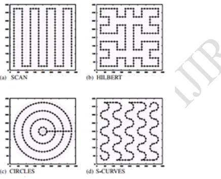
The simplest path is random paths such as RWP (Random Waypoint) and Gauss-Markov path, whose drawback is that they cannot cover the entire ROI to localize all unknown nodes. To overcome this drawback, three paths are used called as Scan, Double-Scan, and Hilbert. Scan and Double-Scan are composed of a series of straight lines, and Hilbert is Hilbert spacing filling curve. They can cover the whole ROI to offer significant benefits compared to a random movement of mobile anchor but the drawback of these methods is path length is doubled and thus energy overhead is increases accordingly.
Circles and S-Curves proposed in aim to avoid the co linearity of virtual anchors, which require the anchor moves along curves instead of straight lines, but they cannot covers entire ROI. CIRCLES can only guarantee that the four corners of the sensing field are covered by expanding the diameter of the concentric circles. As a result, the path length is extended, and the energy consumption is increased. In S-CURVES, the trajectory of the mobile anchor cannot guarantee that each sensor node can construct two valid chords.
Figure 2: Static Path Planning
The objective of path planning algorithm is to optimize the trajectory of the mobile anchor node. It also guarantees that all of the sensor nodes can determine their locations. It proposes obstacle-resistant trajectory to handle the obstacles in the network field. Also this system proposes an optimal path planning method for the mobile anchors used in the localization scheme. A single mobile anchor is used to enable the mobile nodes to construct two chords of a communication circle of which they form the center point, and the intersection of the perpendicular bisectors of these two chords is then calculated in order to pinpoint the node position. However, the mobile anchor moves randomly through the sensing field (i.e., in accordance with the Random Waypoint model), and thus it is possible that some of the sensor nodes cannot be localized. The path planning scheme proposed is specifically designed to 1. Minimize the localization error of the individual mobile nodes 2. Maximize the number of sensor nodes which can determine their locations.
Assuming that the sensor field has a length
and the trajectory of the anchor node has a resolution the total path lengths D of the schemes proposed in this study and in [17] and [18], respectively, are equal to
Where
It is evident that the path length in HILBERT, CIRCLES is shorter than that in the proposed scheme.
MULTIPLE ANCHORS EXTENSION
In the literature, the existing anchor movement strategies use a single mobile anchor node for localization. However, the proposed path planning can be extended to be supported by multiple mobile anchor nodes. As indicated, the beacon collision at sensor nodes can occur if there are multiple anchor nodes moving in the sensing field. With the proposed path planning, anchor nodes should not move along successive vertical segments of the proposed trajectory. Because of the distance between two successive vertical segments , the beacon collision problem happens when a sensor node is within the overlap area of the broadcast coverage of two anchor nodes. In other words, the distance between two anchor nodes should be larger than R. In the scenario of multiple anchor nodes, the distance between two anchor nodes is specified as 2 . Assuming that the sensor field has a length and the anchor trajectory has a resolution , the number of required anchor nodes (n) in the field is qual to
PSO ALGORITHMS FOR WSN LOCALIZATION
In the sensor network, Reference Nodes (RNs) contain a priori location information. The locations of other nodes are determined based upon the RNs. In the sensor networks, when the hop-counts are propagated, the density awareness struggles to incorporate. Range ratio is represented as function of local density which is defined as the connectivity per unit transmission coverage. The RNs broadcast the hop-count and the nodes which hear the broadcast learn that they are one-hop neighbors of RN. Node’s local density determines the distance associated with each hop. The hop-distances at different node densities are gathered together.
Page 8 www.ijiras.com | Email: [email protected] the particles and the information about the locations of best
success are retained. This information is also available to their neighbors. The locations of successful neighbors are also known. These successes guide the movements along with the populations converging at the end of a trial. This is used efficiently for a non-swarm approach.
A candidate solution is given for each particle for optimization problem. The best position of the particle is judged by the particle itself. The neighboring particles determine the position of the best particle in its neighborhood. The global best particle is the best position in the neighborhood when the neighborhood of a particle is the entire swarm. The fitness function measures the performance of each particle and varies depending upon the optimization problem. PARTICLE SWARM OPTIMIZATION (PSO)
Particle swarm optimization (PSO) is a population based stochastic optimization technique developed by Dr. Eberhart and Dr. Kennedy in 1995, inspired by social behavior of bird flocking or fish schooling.
PSO shares many similarities with evolutionary computation techniques such as Genetic Algorithms (GA). The system is initialized with a population of random solutions and searches for optima by updating generations. However, unlike GA, PSO has no evolution operators such as crossover and mutation. In PSO, the potential solutions, called particles, fly through the problem space by following the current optimum particles.
Each particle keeps track of its coordinates in the problem space which are associated with the best solution (fitness) it has achieved so far. (The fitness value is also stored.) This value is called pbest. Another "best" value that is tracked by the particle swarm optimizer is the best value, obtained so far by any particle in the neighbors of the particle. This location is called lbest. when a particle takes all the population as its topological neighbors, the best value is a global best and is called gbest.
The particle swarm optimization concept consists of, at each time step, changing the velocity of (accelerating) each particle toward its pbest and lbest locations (local version of PSO). Acceleration is weighted by a random term, with separate random numbers being generated for acceleration toward pbest and lbest locations.
In past several years, PSO has been successfully applied in many research and application areas. It is demonstrated that PSO gets better results in a faster, cheaper way compared with other methods.
Another reason that PSO is attractive is that there are few parameters to adjust. One version, with slight variations, works well in a wide variety of applications. Particle swarm optimization has been used for approaches that can be used across a wide range of applications, as well as for specific applications focused on a specific requirement.
PSO have an n-dimensional search space, in this candidate solutions are represented by every particle. this equation denotes the position of the particle I for each iteration t. In PSO, each particle travels through the velocity for every iteration and it is denoted as
and it is calculated as
In the above equation j denotes the dimension of the search space and and inertia weight is denoted by w. Personal best position and global best solution is denoted as The pbest and gbest represents the personal best position and global position of the particle I at the iteration t. The both represent the best position found by the particle and the best position found by the entire swarm until the iteration t. Here, the acceleration coefficients are represented by the parameter and the random numbers are denoted by . Range of the velocity is
.
The above equation is calculated for new position of the particle I at the iteration t+1, this calculation happened after updating the velocity.
The above equation is used to reduce the parameter w with the increasing iteration. Denotes the initial and final inertia weight and maximum number of iteration is dented by .
IV. EXPERIMENTAL RESULTS
The proposed algorithm is implemented in NS 2 platform. The performance of the various path planning algorithms was evaluated using three metrics, namely:
The localization error: the average discrepancy between the estimated sensor node location and the actual sensor node location for all the sensor nodes;
The percentage of localized sensor nodes: the ratio of the number of successfully localized sensor nodes to the total number of sensor nodes;
The chord length: the average chord length constructed by the sensor nodes.
The localization error of the proposed scheme for various values of X in the range 0.05 to 0.3 R. It can be seen that the localization error maintains a constant value of just 0.3 0.45 m as the value of X is increased. The table 1 shows the localization error for X in percentage.
X(% of R) Localization Error
5 0.3
10 0.2
15 0.5
20 0.4
25 0.35
30 0.4
Page 9 www.ijiras.com | Email: [email protected]
Figure 1: Localization error versus X of the proposed
scheme. . .
The low value of the localization error arises because the proposed path planning scheme guarantees that the length of all the chords constructed by the sensor nodes exceeds provided that the value of X is less than .
In other words, the proposed path planning scheme successfully resolves the short chord problem inherent in the localization scheme. The figure 1 shows the Localization error
versus X of the proposed scheme. . .
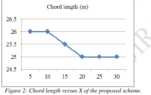
Figure 2: Chord length versus X of the proposed scheme.
. .
Figure 2 shows that the average chord length reduces with an increasing value of X. From inspection, the average chord length varies between 25 and 26 m, and is therefore greater than Accordingly, X was assigned a constant value of 0.05 R in all the remaining simulations.
V. CONCLUSION
Localization is one of the key technologies in wireless sensor networks (WSNs), since it provides fundamental support for many location-aware protocols and applications.
The framework approach ensures that the chords constructed by the individual sensor nodes always have a length greater than . .
In this Research, the trajectory of the mobile anchor node minimized the localization error and guaranteed all of the service node determined their locations. Then, the PSO algorithm determined the trajectory of the mobile anchor
nodes. The path planning strategy method performs in both a smaller localization error and a high percentage of localized sensor nodes by PSO.
VI. FUTURE WORK
In practice applications, obstacle-resistant mobile anchor assisted localization algorithms are needed to deal with the obstacles. For this, the path planning technique must be improved further. Then for other type of mobile anchor path planning method for localization schemes can be analyzed.
REFERENCES
[1] Aung, Aung Distributed Algorithms for Improving Wireless Sensor Network Lifetime with Adjustable Sensing Range, (2007).
[2] Chong Liu, Student Member, IEEE, Kui Wu, Member, IEEE, and Jian Pei “An Energy Efficient Data Collection Framework for Wireless Sensor Networks by Exploiting Spatiotemporal Correlation”.
[3] Dakai Zhu; Yifeng Guo; Tosun, AS., "Multi-path Planning for Mobile Element to Prolong the Lifetime of Wireless Sensor Networks," Embedded and Real-Time Computing Systems and Applications, 2009. RTCSA '09. 15th IEEE International Conference on , vol., no., pp.41,50, 24-26 Aug. 2009
[4] Hongjun Li; Jianwen Wang; Xun Li; Hongxu Ma, "Real-time path planning of mobile anchor node in localization for wireless sensor networks," Information and Automation, 2008. ICIA 2008. International Conference on , vol., no., pp.384,389, 20-23 June 2008.
[5] G. Han, H. Xu, J. Jiang, L. Shu, Y. Hara, and S. Nishio, “Path planning using a mobile anchor node based on trilateration in wireless sensor networks,” Wireless Commun. Mobile Comput., 2011, to be published. [6] Jamal N. Al-Karaki Ahmed E. Kamal, Routing
Techniques in Wireless Sensor Networks: A Survey. [7] Jason Lester Hill, System Architecture for Wireless
Sensor Networks, Spring 2003.
[8] Kavitha, Dr.Janagaraj, “Multiple Mobile Anchors Based Localization Using Particle Swarm Optimization (Pso) For Wireless Sensor Networks”, Journal of Theoretical and Applied Information Technology,10th December 2013. Vol. 58 No.1.
[9] K. Kim, B. Jung, W. Lee, and D. Z. Du, “Adaptive path planning for randomly deployed wireless sensor networks,” J. Inf. Sci. Eng., vol. 27, no. 3, pp. 1091–1106, May 2011.
[10]D. Koutsonikolas, S. M. Das, and Y. C. Hu, “Path planning of mobile landmarks for localization in wireless sensor networks,”
Comput. Commun., vol. 30, no. 13, pp. 2577–2592, Sep. 2007.
Page 10 www.ijiras.com | Email: [email protected] Science, Hawaii International Conference on System
Sciences – 2002.
[12]T.S.Lokhande, Prof. R. R. Shelke, Reviewing Static Path Planning for Mobile Beacons to Localize Mobile Networks, International Journal of Electronics, Communication & Soft Computing Science and Engineering, ISSN: 2277-9477, Volume 3, Issue 2. [13]Liana K. Qabajeh, Laiha Mat Kiah, Mohammad M.
Qabajeh, “Position based routing protocol for Ad Hoc Networks”, Application and Multidisciplinary Aspects of Wireless Sensor Networks Computer Communications and Networks 2011, pp 47-83.
[14]Latiff, L.A.; Ali, A.; Chia-Ching Ooi; Fisal, N., "Location-based geocasting and forwarding (LGF) routing protocol in mobile ad hoc network," Telecommunications, 2005. advanced industrial conference on telecommunications/service assurance with partial and intermittent resources conference/e-learning on telecommunications workshop. aict/sapir/elete 2005. proceedings , vol., no., pp.536,541, 17-20 July 2005. [15]Ping Song; Jiangfeng Li; Kejie Li; Jinlong Liang, "Hybrid
multi-robot path planning strategy based on RRT and fuzzy control in wireless sensor network," Robotics and Biomimetics (ROBIO), 2009 IEEE International Conference on , vol., no., pp.877,881, 19-23 Dec. 2009. [16]Rezazadeh, J.; Moradi, M.; Ismail, AS.; Dutkiewicz, E.,
"Superior Path Planning Mechanism for Mobile
Beacon-Assisted Localization in Wireless Sensor Networks,"Sensors Journal, IEEE , vol.14, no.9, pp.3052,3064, Sept. 2014
[17]Sanjeevkumar Jeevangi, Mallanagouda Biradar, “Optimal Routing and Data Aggregation for Maximizing the Network Lifetime of Wireless Sensors”, International Journal of Advancements in Research & Technology, Volume 2, Issue5, May-2013 122, ISSN 2278-7763. [18]Saurabh Singh, Dr. Harsh Kumar Verma, “Security For
Wireless Sensor Network”, IJCSE, june 2011.
[19]M. L. Sichitiu and V. Ramadurai, “Localization of wireless sensor networks with a mobile beacon,” in Proc. IEEE Int. Conf. Mobile Ad- Hoc Sensor Syst., Oct. 2004, pp. 174–183.
[20]Vibha Yadav, Manas Kumar Mishra, A.K. Sngh and M. M. Gore, Localization Scheme For Three Dimensional Wireless Sensor Networks Using Gps Enabled Mobile Sensor Nodes, (IJNGN),Vol.1, No.1, December 2009. [21]Xue Han; Ma Hong-xu, "Online real-time path planning