Path planning for Mobile Beacon based Iterative
Localization in Wireless Sensor Network
Shweta Ubnare
*, Balram Yadav and Bharti Chourasiya
Date of publication (dd/mm/yyyy): 18/05/2017
Abstract – Wireless sensor network (WSN) is deployed to gather and forward information to the faraway destination. It is very important to aware about the location of the event occurred. This location information may be obtained using manual deployment of sensor nodes or GPS, but this become prohibitive due to increased price. The localization technique in wireless sensor networks can obtained positional information of nodes with some GPS enable nodes called beacon nodes. Randomly deployed WSN needs a large amount of GPS-enabled sensor nodes for localization, this necessitates iterative approach or a mobile beacon node to localize all sensor nodes. However, nodes with sparse connectivity remain unlocalized. In this paper, a iterative mobile beacon based technique is proposed for node localization. Initially, sensor nodes are localized using beacons in the neighborhood, then these localized nodes iteratively localized remaining nodes using multilateration. A Mobile beacon node follow zigzag path in field and broadcast position information. It localized nodes with sparse connectivity. Simulation results show that proposed approach localize all sensor nodes with good localization accuracy.
Keywords – Path Planning, Localization, Mobile Beacon, Wireless Sensor Network, Iterative Processing.
I. I
NTRODUCTIONIn WSNs, sensor nodes are deployed in the real geographical environment and observe some physical behaviors. WSNs have many analytical challenges. Sensors are a small device in size, low-cost accounting, and having low process capabilities. WSN’s applications attracted great attention interest of researchers in recent years [1]. WSNs have a different application such as monitor environmental aspects and physical phenomena like temperature, audio and optical data, habitat monitoring, traffic control monitoring, patient healthcare monitoring, and underwater acoustic monitoring. Data collection without their geographical positions would be useless. Localization of nodes can be achieved by using GPS (global positioning system), but it becomes very expensive if a number of nodes are large in a given network. So far Many algorithms have been come up to solve the localization issue, but due to their application specific nature, most of the solutions are not suitable for wide range of WSNs [2]. Ultra wideband techniques are useful for the indoor environment while extra hardware would be required for the acoustic transmission-based system. In this Unlocalized nodes calculate their location from beacon nodes beacon messages, which needs much power. It localize sensor node with higher accuracy but expensive in terms of energy consumption and processing. Many iterative localization algorithms have been proposed to reduce this communication and computation cost.
However, if one node calculates its wrong location, then this error propagates to overall network and further nodes, and this will lead wrong information of beacon nodes location is propagated [3]. Random deployment of the network also leads to sparse connectivity which decreases the probability of localization [4]. In this paper, a iterative localization mechanism has been proposed for the sensor network. Initially, sensor nodes use multilateration to localize themselves, then broadcast their obtained location in the network. The remaining nodes use original beacon nodes and localized nodes information to locate themselves iteratively. In this, a new path trajectory also proposed for mobile beacon node to localized such nodes that have very less connectivity. Simulation results validate the performance of proposed approach.
The rest of the paper is organized as follows. Section II discusses related work of localization. Section III describes proposed approach in brief. Section IV provides an overview simulation and results analysis. Section V concludes the paper.
II. R
ELATEW
ORKRecently, a large number of localization techniques and algorithms have been proposed for WSNs, and simultaneously many studies have been done to analyze existing localization techniques and algorithms. For example, in [5], Mao et al. first provide an overview of measurement techniques that can be used for WSN localization, e.g., distance related measurements, angle-of-arrival measurements and RSS profiling techniques. Then the one-hop and the multihop localization algorithms based on the measurement techniques are presented in detail, respectively, where the connectivity-based or range-free localization algorithms and the distance-based multi-hop localization algorithms are particularly discussed due to their prevalence in multihop WSN localization techniques. In addition, based on the analysis, the open research problems in the distance-based sensor network localization and the possible approaches to these problems are also discussed.
begin. In the second phase, the measurement techniques, e.g., the angle-of-arrival (AOA) and the time-difference-of-arrival (TDOA) methods are presented. The measurements obtained in the second phase can be used to determine the approximate position of the mobile target node based on localization algorithms, e.g., the Dead Reckoning, the maximum likelihood estimation (MLE) and the Sequential Bayesian estimation (SBE). To the best of our knowledge, the reference [6] is the first survey focusing on MWSNs localization.
In [7], an RWP mobility model is a widely used model mostly due to its simplicity. A random destination is chosen by the mobile anchor and it travels towards the newly chosen location. In one work [8], the authors used the RWP mobility model for facilitating the localization of static nodes. The anchors positional message is transmitted by the mobile anchor at every destination. The primary disadvantage of the RWP mobility model is the non uniform coverage of the network field. It is quite evident that while some points may be visited repeatedly by the mobile anchor while some points may never be visited by the same. It is highly difficult for determining the path length traveled by the anchor as the movement of the anchor may be stopped after a certain time interval or predefined path length.
In [9], a simple and easily implementable mobile anchor trajectory planning scheme named SCAN has been proposed. It uniformly covers the network field. The uniform coverage of the network field helps in ensuring low localization error and receiving of beacons by all the unknown sensor nodes. SCAN divides the square deployment area into sub-squares and connects their centers using straight lines.
The idea of equilateral triangle configuration idea was initially proposed in [10] for the anchor’s placement to help localize the mobile sensors. Based on this idea, the LMAT algorithm is proposed in [11] where optimal anchor positions for the mobile anchor are used for obtaining better localization accuracy and coverage. In this work, it is considered that the mobile anchor moves along an equilateral triangle trajectory and transmits the beacons including the anchor position information at regular intervals.
Recently, in [12], authors proposed a path planning technique called as Z-curve. The proposed trajectory has the ability to successfully localize all the nodes with high precision and in the shortest time. Here, the basic curve of the trajectory is built based on the Z shape. The reason for choosing this shape is that such a trajectory has short jumps to overcome the collinear problem.
In [13], the distance-based localization techniques are surveyed for WSNs. It is impossible to present a complete review of every published algorithm. Therefore, ten representative distance-based localization algorithms that have diverse characteristics and methods are chosen and presented in detail in [13].
Therefore, in [14], range-based and range-free schemes are further divided into two sub-categories: fully schemes and hybrid schemes. That is fully-range-based, hybridrange-based, fully-range-free, and
hybrid-range-free. It is pointed out that hybrid localization algorithms can achieve a better localization performance compared with fully localization ones. However, in hybrid localization algorithms, large computations are required to estimate locations and the time complexity of them is relatively high.
In [15] Mustafa Ilhan Akbas, et al. proposed a localization algorithm for wireless networks with mobile sensor nodes and stationary actors. The proposed localization algorithm overcomes failure and high mobility of sensors node by a locality preserving approach complemented with an idea that benefits from the motion pattern of the sensors. The algorithm aims to retrieve location information at the actor nodes rather than the sensors and it adopts one-hop localization approach in order to address the limited lifetime of the WSAN. The accuracy of the proposed algorithm can be further improved with RSS or other measurement techniques at the expense of increased energy consumption.
In proposed scheme [16], a subsurface current mobility model is adopted and tailored according to the requirements of the scenario. The result presented Through extensive simulations shown that the localization estimation can be realized using local multihop information. In overall, as the multi-hop chains are allowed to become longer, more positions can be estimated with the cost of lower accuracy. The selection of the maximum hop number is, therefore, an issue depending on the requirements of the network.
In [17] CamLy Nguyen et al. proposed a maximum likelihood based multihop localization algorithm called kHopLoc or use in wireless sensor networks that is strong in both isotropic and anisotropic network deployment regions. Compared to other multihop localization algorithms, the proposed kHopLoc algorithm achieves higher accuracy in varying network configurations and connection link models.
In [18] Juan Cota-Ruiz et al. have presented a routing algorithm useful in the realm of centralized range-based localization schemes which is capable of estimating the distance between two non-neighboring sensors in multi-hop wireless sensor networks. This scheme employs a global table search of sensor edges and recursive functions to find all possible paths between a source sensor and a destination sensor with the minimum number of hops.
In [19] Shikai Shen et al. proposed an improved DVHop localization algorithm to ensure the accuracy of localization. this localization algorithm first employs distortion function to select the beacon nodes that can estimate average hop distance and then adopt two-dimensional hyperbolic function instead of the classic trilateration/least square method to determine the locations of unknown nodes, which are very close to their actual locations.
In [21] Xihai Zhang et al. proposed An efficient path planning approach in mobile beacon localization for the randomly deployed wireless sensor nodes. The proposed approach can provide the deployment uniformly of virtual beacon nodes among the sensor fields and the lower computational complexity of path planning compared with a method which utilizes only mobile beacons on the basis of a random movement. The performance evaluation shows that the proposed approach can reduce the beacon movement distance and the number of virtual mobile beacon nodes by comparison with other methods.
Fig. 1. Multilateration : node localization
The related work clearly showed that an optimal algorithm could not be defined yet, and thus a suitable localization algorithm needs to be designed on the specificities of the situations, taking into account the size of the network, as well as the deployment method with node density and the expected results. Our proposed method delved into mobile beacon nodes as well as its path. It is established that they are energy efficient as well as require less in number than only static nodes. In those systems, only a small number of beacons are necessary for constructing the global coordinates, which significantly reduces the system cost.
III. M
ULTILATERATIONWithin different wireless positioning methods, it is found that the multilateration method is widely used. Fig. 1 shows the schematic diagram of the conventional multilateration method. To simplify the following analysis, it is assumed that all the nodes (including the beacon nodes and the non-beacon node) are located in the same 2-dimensional coordinate plane. As shown in figure 1, red circles are the A beacon nodes S1, S2, …SA with fixed two-dimensional coordinates (x1, y1), (x2, y2), …, (xA, yA) and S0 is the non-beacon node (blue circle) with coordinate (x, y). Suppose the distances from the non-beacon node S0 to each beacon nodes S1, S2, …SA are denoted by d1, d2, …, dA, respectively. Then we can get
When the distances d1, d2 …, dA can be measured correctly the coordinate (x, y) of the non-beacon node S0 can then be estimated unbiasedly, which is an ideal case in the applications.
IV. N
ETWORKM
ODELIn this section assumption about the network model is described.
Sensor nodes and base station are static.
The base station does not limit by energy.
Fig. 2. Initial phase localization
beacon nodes are aware of their geographic location.
The distributions of sensor nodes are random over the sensing area.
The sensor nodes are densely deployed in the sensing area.
Sensor nodes are homogeneous in energy level.
A mobile node work as beacon node and do not limit to energy.
V. P
ROPOSEDM
ETHODIn this section, a distributed range-based iterative localization method has been proposed. In this work, two type of sensor nodes i.e. beacon and non-beacon node are deployed in the network. Initially, all non-beacon nodes are localized themselves using multilateration technique. After that, an iterative mechanism is used to localized remaining nonbeacon nodes iteratively. Nodes with less connectivity (less than three neighbors) are localized using a mobile beacon. The proposed method consists three phases: Initial, iterative and mobile. In the first phase, nodes with more than two beacon neighbors are localized using multilateration. In the second phase, localized non-beacon nodes are also used for nodes localization with original beacon nodes. In the last phase, a mobile beacon node follow zigzag path and broadcast its position for node localization.
A. Initial Phase
sensor node id. Once a non-beacon node i receives the beacon packet, it stores the beacon coordinate along with the distance from beacon j to node i obtained by received RSSI value. After receiving beacon packet from minimum three beacon nodes, each non-beacon sensor node i calculates positional coordinates using the multilateration method by taking into considering the distance calculated through the RSSI value of the corresponding beacon node and its coordinates as shown in figure 2. After that, sensor node i broadcasts their coordinates within communication range. These coordinates information would be use for nonbeacons that do not have neighbor beacon nodes.
Fig. 3. Iterative phase localization
B.
Iterative Phase
In this phase, non-beacon nodes are localized iteratively. Node i with less than three beacon nodes j uses sensor nodes which are already localized to obtain location coordinates as shown in figure 3. This is an iterative phase in which each non-beacon node wait for three beacon packet, as soon as it gets required number of the packet, computes their coordinate using multilateration. After that, node i broadcast their estimated coordinates which help to other neighbor nodes to compute their location coordinates. Repeat this process until all nodes get their location which is well connected to the network; it means has more than three neighbors. The remaining nodes are localized in next phase.
C.
Mobile Phase
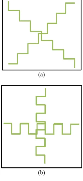
A non-beacon with less connectivity is not able to compute their location. To solve this problem we used a mobile node as an beacon, which moves in a predefined path followed randomly in field and periodical broadcast location coordinates. The mobile beacon path planning mechanism presented in this section is named Zigzag path where the basic curve of the trajectory shown in figure 4 is built based on the Z shape. For each location mobile anchor compute new position using step size (T) defines as
0.2
T
(2)where is the communication range of the mobile beacon node. New position of mobile node computed by adding T into x or y which depends on the moving direction. The key motivation for designing the Zigzag is that such a trajectory has short jumps to overcome the collinear beacons problem and creates a path for transmitting three consecutive noncollinear beacons in order to reduce the localization time and maximize coverage. If the mobile beacon moves on the Zigzag, non beacon nodes have the
chance to be localized more accurately while the trajectory is maintained through the border of the deployment area and the whole network field.
As soon as non-beacon node get three beacon packet from the static or moving beacon, it computes location coordinate as shown in figure 5. Localized non-beacon nodes may also use new position coordinates to update their estimated location on reception of beacon message from mobile beacon node. The received message from mobile
(a)
(b)
Fig. 4. Beacon trajectory
beacon node should have higher received signal strength or nearer than one of the neighboring nodes used for location computation. The selection of beacon coordinates depend on the RSSI value. It can affect the localization accuracy. The topological arrangement of the node is not a constraint. Hence, the all beacon packet considers for location computation. The process of localization is summarized in Algorithm 1.
VI. S
IMULATIONA
NDR
ESULTS
(3)
Algorithm 1 Proposed algorithm
TABLE I
SIMULATION PARAMETERS
(a)
(b)
Fig. 5. Mobile phase localization
A.
Total Number of Deployed Sensor Nodes
To observe the performance of proposed approach we simulate with beacon nodes as 10% of the total node, deployed area 200m200 ,m node communication range is taken as 15% of deployed area. The error in the distance is considered as 10% of the respective distance.
Figure 6 shows the performance of proposed approach increases with increase in the sensor nodes. It is observed that the time taken by mobile node decreases with increase in sensor node. It happens because with an increase in sensor node nodes connectivity increases which increases the chance of getting more neighbor for localization. The average error of localization varies for node densities.
However, localization accuracy increases with deployed
Fig. 7. The performance of proposed approach with beacon nodes
Fig. 8. The performance of proposed approach with varying communication range
sensor nodes shown in Fig 6.
B.
Beacon Nodes
To observe the performance of proposed approach for varying beacon nodes we deploy three hundred sensor nodes in 200m200m area with 13 meters communication range. The error in the distance is considered as 10% of the respective distance.
It is observed that the localization error decreases with increase in beacon nodes as shown in figure 7. This is because beacon nodes provide the true distances for location computation.
C.
Communication Range
To observe the performance of proposed approach with varying connectivity, a different value of communication
range has been taken for simulation. For this four hundred sensor nodes with beacon nodes as 10% of the total node are deployed in 300m300m area. The error in the distance is considered as 10% of the respective distance.
It is observed that the localization error decreases with increase in communication range of the sensor nodes as shown in figure 8. This is because the probability of getting more beacon nodes as a neighbor is increased.
After a certain value of communication range, localization error decrease because measurement error increases with distance.
D.
Deployed Area
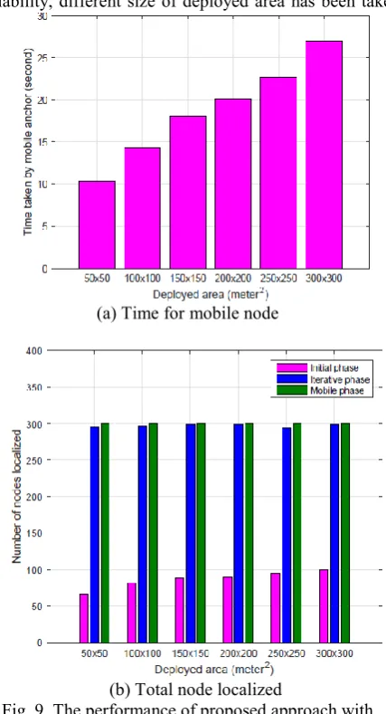
To observe the performance of proposed approach for scalability, different size of deployed area has been taken
(a) Time for mobile node
(b) Total node localized
Fig. 9. The performance of proposed approach with deployed area
the nodes localized. This happens because mobile nodes provide location information of the sparsely connected node.
E.
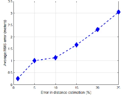
Error in Distance Estimation
To observe the performance of proposed approach for noise tolerance, a different value of measurement noise has been taken for simulation. For this three hundred sensor nodes with beacon nodes as 10% of the total node are deployed in 200m200m area. The communication range of a node is taken as 13% of deployed area. It is observed that the localization error increases with increase in measurement error in distance estimation as shown in figure 10. This is because the probability of getting true distance decreases with measurement error.
F.
Performance Comparison
In this section, we compare the performance of proposed approach with other existing technique. The Efficient Path Planning approach in Mobile Beacon (EPP-MB) technique [21] taken two scenarios for performance analysis. In the
Fig. 10. The performance of proposed approach with varying error in distance estimation
Fig. 11. The performance comparison with EPP-MB in term of beacon nodes
first scenario, the number of beacon nodes are considered for localization and in second, communication range of nodes is considered for analyais. We simulate the proposed approach with same parameters used in [21].
Figure 11 shows the performance comparison between the proposed approach and EPP-MB [21] for varying beacon node density. The average error in localization is taken as the performance measure. It is observed that
proposed approach perform better than existing techniques for varying beacon density as shown in figure 11. For varying communication range, proposed approach perform better for low range, but for higher range, it still performs better than existing methods as shown in figure 12.
Fig. 12. The performance comparison with EPP-MB in term of communication range
VII. C
ONCLUSIONIn this paper, we proposed a distributed iterative localization algorithm that uses the mobile beacon nodes that follow the proposed path in zigzag fashion and broadcasts location coordinates to compute location of non-beacon nodes. A iterative technique also helps to localize sensor nodes with low beacon density. The proposed algorithm is based on the multilateration which used the distance between nodes for location computation. It is found that the localization error is further reduced by receiving multiple beacons from the mobile beacon nodes from the different position during their mobility. The most significant advantages of mobile beacon node over static beacon node are that with less number of mobile beacon nodes the localization over the whole network is achieved, which is preferable for energy constrained WSN. It is found that the proposed approach significant increase the localization accuracy than existing techniques.
R
EFERENCES[1] I. F. Akyildiz, W. Su, Y. Sankarasubramaniam, and E. Cayirci, “Wireless sensor networks: a survey,” Computer networks, vol. 38, no. 4, pp. 393–422, 2002.
[2] A. Savvides, H. Park, and M. B. Srivastava, “The n-hop multilateration primitive for node localization problems,” Mobile Networks and Applications, vol. 8, no. 4, pp. 443–451, 2003. [3] N. Jain, S. Verma, and M. Kumar, “Locally linear embedding for
node localization in wireless sensor networks,” in Computational Intelligence and Communication Networks (CICN), 2015 International Conference on, pp. 126–130, IEEE, 2015. [4] V. K. Chaurasiya, N. Jain, and G. C. Nandi, “A novel distance
estimation approach for 3d localization in wireless sensor network using multi dimensional scaling,” Information Fusion, vol. 15, pp. 5–18, 2014.
[5] X. Li, Y. Zhang, K. Xu, G. Fan, and H. Wu, “Research of localization and tracking algorithms based on wireless sensor network,” Journal of Information & Computational Science, vol. 8, no. 4, pp. 708–715, 2011.
Processing in Sensor Networks, pp. 51–60, IEEE, 2007. [7] T. Camp, J. Boleng, and V. Davies, “A survey of mobility
models for ad hoc network research,” Wireless communications and mobile computing, vol. 2, no. 5, pp. 483–502, 2002. [8] K.-F. Ssu, C.-H. Ou, and H. C. Jiau, “Localization with mobile
anchor points in wireless sensor networks,” IEEE transactions on Vehicular Technology, vol. 54, no. 3, pp. 1187–1197, 2005. [9] D. Koutsonikolas, S. M. Das, and Y. C. Hu, “Path planning of
mobile landmarks for localization in wireless sensor networks,” Computer Communications, vol. 30, no. 13, pp. 2577–2592, 2007.
[10] G. Han, D. Choi, and W. Lim, “Reference node placement and selection algorithm based on trilateration for indoor sensor networks,” Wireless Communications and Mobile Computing, vol. 9, no. 8, pp. 1017–1027, 2009.
[11] G. Han, H. Xu, J. Jiang, L. Shu, T. Hara, and S. Nishio, “Path planning using a mobile anchor node based on trilateration in wireless sensor networks,” Wireless Communications and Mobile Computing, vol. 13, no. 14, pp. 1324–1336, 2013. [12] J. Rezazadeh, M. Moradi, A. S. Ismail, and E. Dutkiewicz,
“Superior path planning mechanism for mobile beacon-assisted localization in wireless sensor networks,” IEEE Sensors Journal, vol. 14, no. 9, pp. 3052–3064, 2014.
[13] A. Kulaib, R. Shubair, M. Al-Qutayri, and J. W. Ng, “An overview of localization techniques for wireless sensor networks,” in Innovations in Information Technology (IIT), 2011 International Conference on, pp. 167–172, IEEE, 2011. [14] G.-J. Yu and S.-C. Wang, “A hierarchical mds-based localization
algorithm for wireless sensor networks,” in 22nd International Conference on Advanced Information Networking and Applications (aina 2008), pp. 748–754, IEEE, 2008.
[15] M. ˙I. Akbas¸, M. Erol-Kantarcı, and D. Turgut, “Localization for wireless sensor and actor networks with meandering mobility,” IEEE Transactions on Computers, vol. 64, no. 4, pp. 1015–1028, 2015.
[16] S. K. Rout, A. Mehta, A. R. Swain, A. K. Rath, and M. R. Lenka, “Algorithm aspects of dynamic coordination of beacons in localization of wireless sensor networks,” in 2015 IEEE International Conference on Computer Graphics, Vision and Information Security (CGVIS), pp. 157–162, IEEE, 2015. [17] C. Nguyen, O. Georgiou, and Y. Doi, “Maximum likelihood
based multihop localization in wireless sensor networks,” in 2015 IEEE International Conference on Communications (ICC), pp. 6663–6668, IEEE, 2015.
[18] J. Cota-Ruiz, P. Rivas-Perea, E. Sifuentes, and R. Gonzalez-Landaeta, “A recursive shortest path routing algorithm with application for wireless sensor network localization,” IEEE Sensors Journal, vol. 16, no. 11, pp. 4631–4637, 2016.
[19] S. Shen, B. Yang, K. Qian, and X. Jiang, “An efficient localization algorithm in wireless sensor networks,” in 2015 Third International Symposium on Computing and Networking (CANDAR), pp. 291–294, IEEE, 2015.
[20] D. Wang, L. Yang, and X. Cheng, “A low-complexity cooperative algorithm for robust localization in wireless sensor networks,” in 2016 International Conference on Computing, Networking and Communications (ICNC), pp. 1–5, IEEE, 2016. [21] X. Zhang, J. Fang, and F. Meng, “An efficient node localization
approach with rssi for randomly deployed wireless sensor networks,” Journal of Electrical and Computer Engineering, vol. 2016, 2016.
A
UTHORS'
P
ROFILESShweta Ubnare is a post graduate student in electronics and communication engineering department of SCOPE college of engineering Bhopal, India. Her research interests include localization in wireless sensor networks.
Balram Yadav is working as Assistant professor in ECE department at SCOPE college of engineering, Bhopal, India. His areas of research interest include image processing, wireless sensor networks.