Command and Control
In the mountains, major axes of advance are limited to accessible valleys and
often separated by
restrictive terrain. The compartmented nature of
the terrain makes it
difficult to switch the effort from one axis to another or to offer mutual support between axes. The battle to control the major lines of communications of Level I develops on the ridges and heights of Level II. In turn,
the occupation of the
dominating heights in
Level II may leave a force
assailable from the
restrictive terrain of Level III. Each operational terrain level influences the application of tactics, techniques, and procedures necessary for successful operations.
CONTENTS
Section I - Assessment of the Situation 2-3
Mission 2-4
Enemy 2-5
Terrain and Weather 2-5
Troops and Support Available 2-8
Time Avai lab Ie. 2-9
Civil Considerations 2-9
Section 11- Leadership 2-10
Section 111-Communications 2-11
Combat Net Radio 2-11
Mobile Subscriber Equipment 2-13
Wire and Field Phones 2-13
Audio, Visual, and Physical Signals 2-14
Messenger 2-14
Section IV- Training 2-15
Initial Training Assessment 2-16
Physical Conditioning 2-16
Mountain Living 2-17
Navigation 2-18
Weapons and Equipment 2-18
Camouflage and Concealment 2-18
Fortifications 2-19
Military Mountaineering 2-19
Driver Training 2-22
Army Aviation 2-23
Reconnaissance and Surveillance 2-23
In mountainous terrain, it is usually difficult to conduct a coordinated battle. Engagements tend to be isolated, march columns of even small elements extremely long, and mutual support difficult to accomplish. Command and control of all available assets is best achieved if command posts are well forward. However, the mountainous environment de-creases the commander's mobility. Therefore, commanders must be able to develop a clear vision of how the battle will unfold, correctly anticipate the decisive points on the battlefield, and position themselves at these critical points.
The success of a unit conducting mountain operations depends on how well leaders control their units. Control is limited largely to a well-thought-out plan and thorough preparation. Boundaries require careful planning in mountain operations. Heights overlooking valleys should be included in the boundaries of units capable of exerting the most influence over them. These boundaries may be difficult to determine initially and may require subsequent adjustment.
During execution, leaders must be able to control direction and speed of movement, maintain proper intervals, and rapidly start, stop, or shift fire. In the mountains, soldiers focus mainly on negotiating difficult ter-rain. Leaders, however, must ensure that their soldiers remain alert for, understand, and follow signals and orders. Although in most instances audio, visual, wire, physical signals, and messengers are used to main-tain control, operations may be controlled by time as a secondary means. However, realistic timetables must be based on thorough reconnaissance and sound practical knowledge of the mountain battlefield.
As in any environment, mountain operations pose both tactical and acci-dent risks. However, since most units do not routinely train for or operate in the mountains, the level of uncertainty, ambiguity, and friction is often higher than in less rugged environments. Commanders must be able to identify and assess hazards that may be encountered in executing their missions, develop and implement control measures to eliminate unneces-sary risk, and continuously supervise and assess to ensure measures are properly executed and remain appropriate as the situation changes. Al-though risk decisions are the commanders' business, staffs, subordinate leaders, and individual soldiers must also understand the risk manage-ment process and must continuously look for hazards at their level or within their area of expertise. Any risks identified (with recommended risk reduction measures) must be quickly elevated to the chain of com-mand (see FM 3-100.14).
SECTION I - ASSESSMENT OF THE SITUATION
2-1. Although higher-elevation terrain is not always key, the structure of a mountain area of operations (AO) often forms a stairway of key terrain fea-tures. Identification and control of dominant terrain at each operational ter-rain level form the basis for successful mountain maneuver. Key terrain fea-tures at higher elevations often take on added significance due to their inac-cessibility and ease of defense. To maintain freedom of maneuver, command-ers must apply combat power so that the terrain at Levels II and III can be exploited in the conduct of operations. Successful application of this concept requires commanders to think, plan, and maneuver vertically as well as hori-zontally.
2-2. Mountain operations usually focus on lines of communication, choke points, and dominating heights. Maneuver generally attempts to avoid strengths, envelop the enemy, and limit his ability to effectively use the high ground. Major difficulties are establishing boundaries, establishing and main-taining communications, providing logistics, and evacuating wounded. Throughout the plan, prepare, and execute cycle, commanders must continu-ously assess the vertical impact on the mission, enemy, terrain and weather, troops and support available, time available, civil considerations (METT-TC).
HISTORICAL PERSPECTIVE
Importance of Controlling Key Terrain:
Mustafa Kemal at Gallipoli (April 1915)
German Fifth Army Commander General von Sanders expected a major Al-lied landing in the north, at Bulair. The British, however, were conducting a feint there; two ANZAC divisions were already landing in the south at Ari Burnu (now known as "ANZAC cove") as the main effort. The landing beaches here were hemmed by precipitous cliffs culminating in the high ground of the Sari Bair ridge, a fact of great importance to the defense. Only one Ottoman infantry company was guarding the area. Although prewar plans had estab-lished contingencies for using 19th 10, Kemal, the division commander, had received no word from his superiors regarding the developing scenario. Nev-ertheless, understanding that a major Allied landing could easily split the pen-insula, he decided that time was critical and set off for Ari Burnu without wait-ing for his senior commander's approval. In his march toward Ari Burnu that morning, he recognized that the hilly terrain in general and the Sari Bair ridge in particular were of vital strategic importance: if the enemy captured this high ground they would be in an excellent position to cut the peninsula in half.
Kemal now engaged the enemy. He impressed upon his men the importance of controlling the hilltops at all costs, issuing his famous order: "I am not or-dering you to attack. I am oror-dering you to die. In the time it takes us to die, other forces and commanders can come and take our place." Despite being outnumbered three-to-one, the Turkish counterattack stabilized their position and prevented the Allies from capturing the Sari Bair ridge. Nightfall brought about a lull in the fighting. There was some sniping and a few local encounters on 26 April, and on 27 April Kemal finally received major reinforcements. The front stabilized and the opposing armies settled down into trench warfare. On 16 January 1926, the Allies admitted defeat and withdrew.
The 19th ID's counterattack, which prevented the ANZAC from establishing themselves on the Sari Bair ridge, may well have decided the outcome of the entire Gallipoli campaign. Despite his lack of situational knowledge, Kemal in-stinctively understood the enemy's intent and, recognizing the importance of controlling the hilltops and ridgelines, was committed to concentrating his combat power to seize and hold this key terrain.
Compiled from "The Rock of Gallipoli," Studies of Battle Command, George W. Gawrych
MISSION
2-3. Mission analysis must include the spatial and vertical characteristics of the AO. Although defeating the enemy continues to be the basic objective of tactical operations, the task of controlling specific operational terrain levels will be paramount. At brigade level and below, major tactical objectives are normally translated into tasks pertaining to seizing, retaining, or controlling specific dominating heights at either Level II or Level III. Therefore, it is im-perative to identify the tasks and assets necessary to access each operational terrain level.
smaller-scale attacks, utilizing the full height, width, and depth of their area of operations. Consequently, commanders must always consider the impact of decentralization on security.
2-5. One method of maintaining freedom of action is to seize or hold key ter-rain. In the mountains, key terrain is frequently identified as terrain that is higher than that held by the enemy. Seizing this terrain often depends on long and difficult envelopments or turning movements. Therefore, the speci-fied and implied tasks associated with mobility and sustainment, as well as command and control, must be considered in terms of their vertical difficulty.
ENEMY
2-6. An enemy will nor-mally position forces in depth and height along likely avenues of approach. Mountain terrain facili-tates wide dispersal, al-lowing relatively small units to hold dominant ter-rain in a connected system of strong points. To
pre-vent bypassing and envel- . .
opment attempts the en- Figure 2-1. Factors Affecting Assessment of emy may adopt' a many- the Enemy Situation
tiered, perimeter defense. Aside from the relative size of forces, the type of enemy units and their equipment must be compared with those of friendly forces, to include a comparison of the suitability of forces, tactics, and train-ing. When considering the enemy's ability to operate in mountainous terrain, commanders should consider how well the enemy can accomplish the tasks and actions listed in Figure 2-1. Again, in analyzing both enemy and friendly factors during mountain operations, the vertical, as well as the horizontal, perspective should be fully integrated into all aspects of the assessment.
.
Utilize the environment to his advantageConduct air operations
Conduct decentralized operations Utilize the terrain in Levels II and III Employ obstacles or barriers to restrict maneuverability
Conduct limited-visibility operations Sustain his maneuver elements
.
.
.
.
.
.
TERRAIN AND WEATHER
2-7. As in all military operations, terrain analysis involves observation and fields of fire, cover and concealment, obstacles, key terrain, and avenues of approach (OCOKA). Terrain often influences the conduct of operations more in the mountains than on flatter terrain. The mountains form the nonlinear and vertical structure of the battlefield, and the influences of geography and climate dictate the extent to which commanders modify tactics. Examples of these difficulties are often encountered in the concentration of forces, as well as in the maintenance of command and control.
on a preliminary course of action, he should immediately initiate a detailed terrain reconnaissance.
2-9. In a mountainous environment, the terrain normally favors the defender and necessitates the conduct of limited visibility operations. Highly trained units can achieve significant tactical gains and decisive victories by exploiting limited visibility. However, limited visibility operations in mountainous ter-rain require precise planning, careful daylight reconnaissance, exceptionally good command and control, and a high degree of training. Imaginative and bold limited visibility operations can minimize the advantage of terrain for the defender and shift the balance of combat power to the side that can best cope with or exploit limited visibility.
OBSERVATION
AND FIELDS OF FIRE 2-10. Although moun-tainous terrain generally permits excellent long-range observation and fields of fire, steep slopes and rugged terrain affect a soldier's ability toaccu-rately estimate range Figure 2-2. Factors Affecting Observation
and frequently cause and Fields of Fire
large areas to be hidden from observation. The existence of sharp relief and dead space facilitates covert approaches, making surveillance difficult despite such long-range observation. Four factors that influence what can be seen and hit in mountainous terrain are listed in Figure 2-2.
1. The ability to observe and identify tar-gets in conditions of bright sunlight 2. The ability to estimate range in clear air
3. The ability to applywind corrections 4. The ability to shoot accurately up and
down vertical slopes
COVER AND CONCEALMENT
2-11. The identification and proper use of the cover and concealment provided by mountainous terrain are fundamental to all aspects of mountain opera-tions. The ridge systems found in Level II may provide covert approaches through many areas that are hidden from observation by the vegetation and relief. The difficulties a force encounters in finding available cover and con-cealment along ridges are fewer than those on the peaks, especially above the timberline. Uncovered portions of an approach leave a force exposed to obser-vation and fire for long periods. The enemy can easily detect movement in this region, leaving commanders with three primary options to improve cover and concealment:
1. Identify and exploit avenues of approach the enemy would consider unlikely, due to their difficult ascent or descent.
2. Negotiate routes during periods oflimited visibility.
3. Provide overwhelming route security.
OBSTACLES
force perspective. They must look specifically at the degree to which obstacles restrict operations, and at the ability of each force to exploit the tactical op-portunities that exist when obstacles are employed. Man-made obstacles used in conjunction with restrictive terrain are extremely effective in the moun-tains; however, their construction is very costly in terms of time, materiel, transportation assets, and labor. Commanders must know the location, ex-tent, and strength of obstacles so that they can be incorporated into their scheme of maneuver.
KEY TERRAIN
2-13. Key terrain generally increases in importance with an increase in ele-vation and a decrease in accessibility. In the mountains, however, terrain that is higher than that held by the opposing force is often key, but only if the force is capable of fighting there. A well-prepared force capable of maneuver in rugged terrain can gain an even greater advantage over an ill-prepared enemy at higher elevation levels.
2-14. The vast majority of operations in the mountains requires that the commander designate decisive terrain in his concept of operations to commu-nicate its importance to his staff and subordinate commanders. In operations over mountainous terrain, the analysis of key and decisive terrain is based on the identification of these features at each of the three operational terrain levels. There are few truly impassable areas in the mountains. The com-mander must recognize that what may be key terrain to one force may be an obstacle to another force. He must also recognize that properly trained com-batants can use high obstructing terrain as a means to achieve decisive victo-ries with comparatively small-sized combat elements.
AVENUES OF APPROACH
2-15. In mountainous terrain, there are few easily accessible avenues of ap-proach, and they usually run along valleys, defiles, or the crests and spurs of ridges. This type of geography allows the defender to economize in difficult terrain and to concentrate on dangerous avenues of approach. A typical offen-sive tactic is to conduct a coordinated assault with the main effort along ac-cessible avenues of approach, and supporting efforts by one or more maneu-ver elements on difficult and unexpected avenues of approach. Normally, high rates of advance and heavy concentration of forces are difficult or impos-sible to achieve along mountainous avenues of approach. Relief features may create large areas of dead space that facilitate covert movement. Units may use difficult and unlikely avenues of approach to achieve surprise; however, these are extremely high-risk operations and are prone to failure unless forces are well trained and experienced in mountaineering techniques. In mountainous terrain, the analysis of avenues of approach should be based on a thorough reconnaissance and evaluated in terms of the factors listed in
Figure 2-3 on page 2-8.
WEATHER
~ccurate weat~er inform a-
.
Ability to achieve surprisetI~n about thel~ AO. Ter-
.
Vulnerability to attack fromram has a dOI~.mant effect surrounding heights
on local clImate. and. Ability to provide mutual support to weathe~ patterns m. the forces on other avenues of approach
mountams. Mountamous
.
Effect on rates of advanceareas are subject to fre-
.
Effect on command and controlquent and r.apid c~anges of
.
Potential to accommodate deceptionweather,. mcluding fog, operations
strong WInds, extreme .heat
.
Abilityto support necessary es and
and cold, and heavy ram or
ess operations
snow. Thus, many forecasts.
Access to secure rest and halt sites
that describe weathe.r over.
Potential to fix the enemy and reduce
large areas of terram are
the ossibilit of retreat
inherently inaccurate.
Commanders must be able Figure 2-3. Factors Affecting Analysis to develop local, terrain- of Avenues of Approach
based forecasts by combining available forecasts with field observations (local temperature, wind, precipitation, cloud patterns, barometric pressure, and surrounding terrain). Forecasting mountain weather from the field improves accuracy and enhances the ability to exploit opportunities offered by the weather, while minimizing its adverse effects (see Appendix B).
TROOPS
AND
SUPPORT
AVAILABLE
2-17. Commanders must assess the operational and tactical implications of the restrictive environment on mobility, protection, firepower, and logistics. The complex task of arranging activities in time, space, and purpose requires commanders to fully understand the impact of elevation, weather, and visi-bility on the capabilities of his subordinate elements and relative combat power. Mountainous terrain and weather can greatly enhance the relative combat power of defending forces and, conversely, it can drastically reduce those of the attacking forces. For example, an infantry battalion may be in-adequate to defeat a defending infantry company in the mountains. Instead, an infantry battalion may only be capable of defeating a well-positioned in-fantry platoon. However, commanders must carefully consider each unique situation and weigh all tangible and intangible aspects of combat power (ma-neuver, firepower, leadership, protection, and information) when comparing strengths and determining the forces necessary to accomplish the mission.
2-18. Commanders must also assess the proper mix of heavy and light forces that capitalizes on the unique strengths that each type of force can bring to mountain operations while minimizing their limitations. While generally complicating command and control, an appropriate mix allows commanders more flexibility in the synchronization of their operations. Additionally, the difficulty providing combat support and combat service support for mountain operations must be evaluated to determine if the proportion of support troops to combat troops is sufficient.
Commanders may need to slow the pace of their operation, transition to the defense for short periods, or rotate units to ensure that their soldiers are physically capable of striking effectively at decisive times and locations. Too often, commanders consider only the operational readiness (OR) rate of equipment and logistics levels when determining their overall ability to con-tinue offensive actions. Failure to consider this intangible human aspect may result in increased loss of lives and mission failure.
2-20. Vertical operations are an integral part of mountain operations and are one means to improve the success of decisive engagements. Commanders must review the state of training of their units to ensure they are adequately prepared to maneuver and fight at various elevations. Increased require-ments for aviation support require aviation units to be capable of operating in the specific mountain environment. Units must also have sufficient numbers of pathfinders and trained air assault personnel to select and mark landing zones (LZs) and prepare sling loads.
TIME AVAILABLE
2-21. In the mountains, proper tim-ing is fundamental to creating oppor-tunities to fight the enemy on favor-able terms. Restrictive terrain, weather, the accumulation of chance errors, unexpected difficulties, and the confusion of battle increase the time necessary to assemble, deploy, move, converge, and mass combat power, effectively decreasing the amount of time available to plan and prepare. To optimize the time avail-able, commanders must continuously evaluate the impact of reduced mo-bility caused by the weather and
ter-rain. At times, commanders may need to conduct a tactical pause to facilitate the concentration of combat power at a decisive point. However, they must consider time with respect to the enemy as time available is always related to the enemy's ability to execute his own plan, prepare, and execute cycle. Fig-ure 2-4 summarizes the time considerations that are different from or greater than those encountered on flatter terrain.
.
Adaptability of plans to the terrain and varying weather Increased time needed to conduct reconnaissance,execute movements, and
synchronize events on the
battlefield
Significant variance in the number of hours of visibility with season and elevation
.
.
Figure 2-4. Factors Affecting Time Available
CIVIL
CONSIDERATIONS
2-22. Generally, civilian population centers will be located at the lower eleva-tions of Level I close to sources of water and along major lines of communica-tions. Refugees and displaced civilians may increase congestion on the al-ready limited road and trail networks normally found in mountainous envi-ronments, further complicating maneuver and sustaining operations.
against the impact on civilians and their local economy. While the purchase of goods and services from the local economy is generally welcomed, it may serve to inflate prices and make it impossible for local civilians to purchase their own scarce and needed supplies.
2-24. In mountainous regions, commanders often encounter a populace of di-verse political and ethnic orientation that may support, oppose, or be am-bivalent to US operations or the presence of US forces. Depending on friendly force objectives, commanders may conduct public relations, civil affairs, hu-manitarian assistance, and psychological operations (PSYOP) to influence perceptions and attitudes of neutral or uncommitted parties. Even if com-manders choose not to commit resources to enlist civilian sympathy and sup-port, they must still adjust their operations to minimize damage and loss of life to innocent civilians.
SECTION II
-
LEADERSHIP
2-25. To help ease their anxiety in combat, soldiers must have confidence in their leaders. This confidence may diminish rapidly unless leaders demon-strate the ability to lead over formidable terrain and under the most difficult weather conditions. Superficial knowledge of mountain warfare and igno-rance or underestimation of mountain hazards and environmental effects may result in mission failure and the unnecessary loss of soldiers' lives.
2-26. Effective leadership in mountain operations combines sound judgment with a thorough understanding of the characteristics of the mountain envi-ronment. Commanders must first develop flexible and adaptable leadership throughout the chain of command. They must then be able to understand and exploit the operational and tactical implications of the mountain environ-ment, as well as its effects on personnel, equipment, and weapons. The keys to meeting this challenge are proper training and operational experience in the mountains. To fight effectively, leaders creatively exploit the opportuni-ties offered by the mountain environment while minimizing the adverse ef-fects it can have on their operations.
SECTION III - COMMUNICATIONS
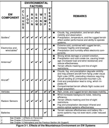
2-28.The communications means available to support operations in moun-tainous regions are the same as those to support operations in other regions of the world. However, rapid and reliable communications are especially diffi-cult to achieve and maintain in mountainous areas. The mountainous envi-ronment requires electronic equipment that is light, rugged, portable and able to exploit the advantages of higher terrain. The combined effects of ir-regular terrain patterns, magnetic and ionospheric disturbances, cold, ice, and dampness on communications equipment increase operating, mainte-nance, and supply problems and require precise planning and extensive coor-dination.
COMBAT NET RADIO
SINGLE-CHANNEL GROUND AND AIRBORNE RADIO SYSTEMS (SINCGARS)
2-29. The Single-channel Ground and Airborne Radio System (SINCGARS) family of frequency modulation (FM) radios is good for the control of battalion and smaller-sized units operating in a mountainous environment (see FM 6-02.32 and FM 6-02.18). If available, hands-free radios, such as helmet-mounted radios, are an excellent means of communication for small unit tac-tics and close-in distances, particularly while negotiating rugged terrain. In colder environments, shortened battery life greatly reduces the reliability of manpacked systems that rely on constant voltage input to maintain maxi-mum accuracy.
2-30. Since even a small unit may be spread over a large area, retransmission sites may be needed to maintain communications and increase range. These sites require extensive preparation and support to ensure the survival of per-sonnel and the continued maintenance of equipment. Retransmission systems are often placed on the highest accessible terrain to afford them the best line-of-sight; however, through simple analysis, these locations are often predict-able and make them more vulnerpredict-able to enemy interdiction. The importance and difficulty of maintaining adequate communications in mountainous ter-rain requires commanders to devote additional resources for the protection of these limited assets and operators skilled in the proper use of cover and con-cealment, noise and light discipline, and other operations security (OPSEC) measures.
SATELLITE COMMUNICATIONS (SATCOM)
2-32. Satellite communications (SATCOM) terminals are light, small, portable ground termi-nals that are able to communi-cate in spite of rugged terrain. During operations in mountain-ous areas having little or no in-frastructure to support com-mand and control, satellite
communications become the primary means of communications. Single chan-nel SATCOM are currently transmitted over the ultrahigh frequency (UHF) band and readily support forces operating in the mountains, while providing worldwide tactical communications, in-theater communications, combat net radio (CNR) range extension, and linkage between elements of long-range surveillance units (LRSUs) and Army special operations forces (ARSOF). SATCOM can network with multiple users, communicate while enroute, penetrate foliage while on the ground, and has several other advantages making it an ideal system for mountain communications (see Figure 2-5). However, limitations include restricted access, low-rate data communications, and lack of antijam capability. Commanders should review FM 6-02.11 for further information on the employment of SATCOM.
.
Greater freedom from sitingrestrictions
Extended range, capacity, and
coverage
Mobility and rapid employment
Extremely high circuit reliability
Figure 2-5. SATCOM Advantages
.
.
.
COMMAND AND CONTROL (C2) AIRCRAFT
2-33. Using C2 aircraft can assist the commander in overcoming ground mo-bility restrictions and may improve communications that would otherwise limit his ability to direct the battle. In the mountains, terrain masking, while making flight routing more difficult, may provide the degree of protection needed to allow an increased use of aircraft. To avoid radar or visual acquisi-tion and to survive, C2 aircraft must use the same terrain flight techniques employed by other tactical aviation units. This flight method often degrades FM communications and reinforces the requirement for radio relay or re-transmission sites.
ANTENNAS AND GROUNDS
2-34. Directional antennas, both bidirectional and unidirectional, may be needed to increase range and maintain radio communications. Although easy to fabricate, directional antennas are less flexible and more time-consuming to set up. Positioning of all antennas is also crucial in the mountains because moving an antenna even a small distance can significantly affect reception.
the exhaust pipe of a vehicle and directing the hot air on the ice until it melts. However, soldiers must exercise great care to ensure that the antenna is not damaged in their attempts to dislodge the ice.
2-36. Ground rods and guy wires are often difficult to drive into rocky and frozen earth. Mountain pitons are excellent anchors for antenna guys in this type of soil. In extreme cold, ropes can be frozen to the ground and guys tied to these anchor ropes. Adequate grounding is also difficult to obtain on frozen or rocky surfaces due to high electrical resistance. Where it is possible to in-stall a grounding rod, it should be driven into the earth as deep as possible or through the ice on frozen lakes or rivers. Grounding in rocky soil may be im-proved by adding salt solutions to improve electrical flow.
MOBILE SUBSCRIBER
EQUIPMENT
2-37. Like FM, mobile subscriber equipment (MSE) requires a line-of-sight transmission path and a tactical satellite or several relay sites to overcome mountainous terrain and maintain MSE connectivity (FM 6-02.55 contains in-depth information concerning the deployment and employment of MSE).
WIRE AND FIELD PHONES
2-38. Wire is normally one of the most reliable means of communication. Un-fortunately, in rugged mountains and particularly during the winter months, wire is more difficult and time consuming to install, maintain, and protect. Wire may be dispensed in mountain areas by tracked or wheeled vehicle, foot, skis, snowshoes, or oversnow vehicles. As in any environment, units must pe-riodically patrol their wire lines to ensure that they have remained camou-flaged and that the enemy has not tapped into them.
2-39. Snow-covered cables and wire can cause the loss of many man-days in recovering or maintaining circuits. This can be avoided by pulling the cable from under the snow after each snowfall and letting it rest just below the sur-face of the snow. Trees or poles can be used to support wire. Allowances must be made for drifting snow when determining the height above ground at which to support the lines. However, when crossing roads, it is preferable to run the wire through culverts and under bridges rather than bury or raise wire overhead. In addition to ease, this technique reduces maintenance re-quirements associated with vehicles severing lines, particularly with higher volumes of traffic on limited road networks. If long-distance wire communica-tions are required, the integration of radio relay systems must be considered.
2-40. Great care must be taken in handling wire and cables in extreme cold weather. Condensation and ice on connectors make connecting cables difficult and can degrade the signal path. When rubber jackets become hard, the ca-bles must be protected from stretching and bending to prevent short circuits caused by breaks in the covering. Therefore, all tactical cable and wire should be stored in heated areas or warmed prior to installation. TC 24-20 provides more detailed information on the installation and maintenance of wire and cable.
difficulties encountered in laying and maintaining wire in these sites of lim-ited duration. The batteries that are used to operate field telephones and switchboards are subject to the same temperature limitations as those used to power tactical radio sets.
2-42. When used with a hands-free phone, commercially available rope with a communication wire in it is ideally suited for mountain operations. This sys-tem is lightweight and easy to manage, and provides an added measure of se-curity during limited visibility operations. In addition to the standard uses, since it functions as both a rope and a wire, it can be used to control move-ment on all types of installations, and it can serve as a primary means of communication for climbing teams.
AUDIO, VISUAL, AND PHYSICAL
SIGNALS
2-43. Leaders can use simple audio signals, such as voice or whistles, to lo-cally alert and warn. Sound travels farther in mountain air. Although this ef-fect may increase the possibility of enemy detection, interrupting terrain, wind conditions, and echoes can restrict voice and whistle commands to cer-tain directions and uses.
2-44. Like audio signals, visual signals such as pyrotechnics and mirrors have limited use due to enemy detection, but may work for routine and emer-gency traffic at the right time and place. Blowing sand or snow, haze, fog, and other atmospheric conditions may periodically affect range and reliability.
2-45. Units should use hand and arm signals instead of the radio or voice whenever possible, especially when close to the enemy. Luminous tape on the camouflage band, luminous marks on a compass, or flashlights may be used as signals at night over short distances. Infrared sources and receiving equipment, such as night vision goggles, aiming lights, and infrared filters for flashlights, can be used to send and receive signals at night. However, an en-emy outfitted with similar equipment can also detect active devices.
2-46. A tug system is a common method of signaling between members of a roped climbing team. However, tug systems are often unreliable when climb-ers are moving on a rope or when the distance is so great that the friction of the rope on the rock absorbs the signals. Separate tug lines can be installed in static positions by tying a string, cord, or wire from one position to the next. Soldiers can pass signals quietly and quickly between positions by pulling on the tug line in a prearranged code.
MESSENGER
.
Mountaineering skills.
Air assault and air movement
operations
.
Deception
.
Stealth and infiltration.
Limited visibility operations.
Patrolling.
Reconnaissance
.
Communications.
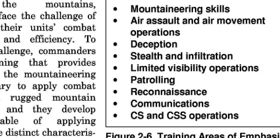
CS and CSS operationsSECTION IV
-TRAINING
2-48. Because US forces do not routinely train in a mountain environment, they must make extensive preparations to ensure individual and unit effec-tiveness. Ultimate success in the mountains depends largely on developing cohesive, combat-ready teams consisting of well-trained soldiers. To be suc-cessful, commanders must understand the stratification of mountain warfare, recognize the unique aspects of leadership required, and implement training programs that prepare soldiers for the rigors of mountain fighting.
2-49. In the mountains, commanders face the challenge of maintaining their units' combat effectiveness and efficiency. To meet this challenge, commanders conduct training that provides soldiers with the mountaineering skills necessary to apply combat power in a rugged mountain environment, and they develop leaders capable of applying doctrine to the distinct
characteris-tics of mountain warfare. Figure 2-6. Training Areas of Emphasis
2-50. The ability to apply doctrine and tactics in mountainous environments is not as easy to develop as technical proficiency. Training, study, and garri-son experimentation may provide the basis for competence. However, only through experience gained by practical application in the mountains will leaders become skilled in mountain warfare. Proficiency in the areas listed in Figure 2-6will provide commanders with a degree of flexibility in the applica-tion of doctrine to a mountain area of operations.
2-51. The best combat and combat support plans cannot ensure victory unless commanders concentrate on developing a leadership climate that is derived from the human dimension of mountain warfare. The complexities of moun-tain combat make it extremely important to establish training programs that modify the traditional application of tactics so that units can reach their full potential. Training must simulate the tempo, scope, and uncertainty of moun-tain combat to create the versatility required to capitalize on the harsh envi-ronment as a force multiplier.
INITIAL TRAINING ASSESSMENT
2-53. In addition to the questions applicable to every mission, commanders must consider the following when preparing for operations in a mountainous environment:
.
What kind of mountains will the unit be operating in?.
What elevations will the unit be operating at?.
What are the climatic and terrain conditions of the AO?.
Are at least two years of accurate weather reports available (see Appendix B)?.
When must the unit be ready to move?.
What training resources are needed and available?.
Are local training areas and ranges available?.
If not, what alternative arrangements can be made?.
What available training areas most closely resemble the AO?.
What special equipment does the unit require?.
What training assistance is available?.
Does the unit have former mountain warfare instructors, military mountaineers, or others with experience in a mountainous environment?.
Are instructors available from outside the unit?.
What special maintenance is required for weapons and equipment?.
What is the level of physical fitness?.
What additional combat, combat support, and combat service support units are necessary to accomplish the operational missions?.
Can specific units be identified for possible coordinated training?.
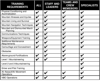
Will allied and multinational troops participate?2-54. As commanders get answers to these and other questions, they must develop training programs to bring their units to a level where they will be fully capable of operating successfully in mountainous conditions. To do this, they must establish priorities for training. The training requirements listed in Figure 2-7 are only a guide. Commanders should add, delete, and modify the tasks as necessary, depending on the specific AO, the state of readiness of their units when they begin preparations for mountain operations, and the time and facilities available (see FM 7-10).
PHYSICAL
CONDITIONING
TRAINING
I I I
TEAMS AND
I
ALL STAFF AND CREW SPECIALISTS
REQUIREMENTS LEADERS
MEMEBERS
Physical Conditioning and
V'
V'
V'
V'
Acclimatization
Mountain Illnesses and Injuries
V'
V'
V'
V'
Mountain Living and Survival
V'
V'
V'
V'
Mountain Navigation Techniques
V'
V'
V'
V'
Mounted and Dismounted March
V'
V'
V'
V'
Planninq
Communications Techniques
V'
V'
V'
V'
Weapons/Equipment Training
V'
V'
V'
V'
Additional Maintenance
V'
V'
V'
V'
Requirements
Camouflage and Concealment
V'
V'
V'
V'
Obstacles
V'
V'
Above-ground Fortifications
V'
V'
V'
V'
Level 1 Mountaineering
V'
V'
V'
V'
Level 2 and 3 Mountaineering
V'
Driver and Pilot Training
V'
Air Assault/Air Movement
V'
V'
V'
V'
Operations
NBC Operations
V'
V'
V'
V'
Figure 2-7. Mountain Preparatory Training
thinner atmosphere at higher altitudes. Therefore, training must emphasize exercises designed to strengthen leg muscles and build cardiovascular (aero-bic) endurance (see FM 3-25.20). Frequent marches and climbs with normal equipment loads enhance conditioning and familiarize soldiers with mountain walking techniques.
MOUNTAIN LIVING
2-56. Successful mountain living requires that personnel adjust to special conditions, particularly terrain and weather. To develop confidence, soldiers should train in conditions that closely resemble those they will face. Lengthy exercises test support facilities and expose soldiers to the isolation common to mountain operations. The mountain area of operations can be harsh, and training should develop soldiers who possess the necessary field craft and psychological edge to operate effectively under mountainous conditions. Al-though FM 4-25.10 and FM 3-25.76 do not specifically address mountain
environments, much of their information applies. Regardless of the level of technical mountaineering training required, all soldiers deploying to a
NAVIGATION
2-57. Navigation in the moun-tains is made more difficult be-cause of inaccurate mapping, magnetic attraction that affects compass accuracy, and the ir-regular pace of the soldiers. It is easy to mistake large terrain fea-tures that are very far away for features that are much closer. The increased necessity for limited-visibility operations re-stricts the use of terrain tech-niques as the primary means of
determining and maintaining direction. Individuals must train to use a vari-ety of equipment, such as a compass, an altimeter, global positioning system devices, and maps, as well as learn techniques pertaining to terrestrial navi-gation, terrain association, dead reckoning, resectioning, and artillery mark-ing (see FM 3-25.26).
.
Temperature extremes andclothing requirements
Bivouac techniques and shelter
construction
Elevation and rarified air effects Hygiene, sanitation, and health hazards
Locating and purifying water
Food-gathering techniques
.
.
.
.
.
Figure 2-8. Mountain Living Training
WEAPONS
AND EQUIPMENT
2-58. Nearly every weapon or piece of equipment familiar to the soldier is af-fected to some degree by the mountain environment. In addition to honing skills, training must focus on the specific operational area and ways to over-come anticipated environmental impacts when using weapons and equip-ment.
2-59. Individual marksmanship training must emphasize the effect of wind and include practical training in wind measurement techniques and adjusted aiming points (holdof£). Practical training in range estimation techniques, combined with using laser range finders, M19 binoculars, target reference points, and range cards, helps to overcome difficulties in range estimation.
2-60. In the conduct of their preparations, commanders should strive to in-crease the number of qualified snipers within their units, as they are ideal in the mountains and can be used to adversely affect enemy mobility by deliv-ering long range precision rifle fire on selected targets. They can inflict casu-alties, slow enemy movement, lower morale, and add confusion to enemy op-erations. A single sniper team in well-concealed positions, such as mountain passes, can severely impede enemy movement (see FM 3-21.20 and FM 3-91.2 for further information on sniper employment).
CAMOUFLAGE
AND CONCEALMENT
equipment should be solid white. However, with less than 15 percent snow cover, standard patterns should be maintained.
2-62. Snow provides excellent conditions for threat thermal and ultraviolet sensor detection. To counter these types of sensors, soldiers must be trained to utilize the terrain to mask themselves and their weapons and equipment from enemy detection. The mountainous terrain often limits the access routes to and from selected positions. Commanders must take appropriate measures to conceal vehicle tracks and limit movement times to periods of limited visi-bility. Snow presents a significant problem, making movement discipline an absolute requirement. When moving, leaders should be trained to follow the shadows along windswept drift lines as much as possible. Drivers should learn to avoid sharp turns, which are easily recognizable in the snow, and follow existing track marks where possible.
FORTIFICATIONS
2-63. Fighting and protective positions in the mountains do not differ signifi-cantly from other environments, except in areas of snow and rock (see FM 3-34.112 for more information on common survivability positions and FM 3-97.11 for positions created in snow). Digging positions in rocky ground is dif-ficult and often impossible. If demolitions, pneumatic drills, and jackham-mers are available, positions may be blasted or drilled in the rock to afford some degree of protection. More often, it will be necessary to build above-ground positions by stacking boulders, stones, and gabions. If possible, exist-ing rock formations should be used as structural wall components.
2-64. If above-ground positions are to be used, considerable care should be taken to avoid siting them in view of any likely enemy avenues of approach. Even a two-man position is difficult to conceal if it is above the timberline. Camouflage nets and the use of background rocks are necessary to break up the outline of the position and hide straight edges.
2-65. Positions should be built of the largest rocks available, wedged securely together. Extreme care should be taken that the walls are stable and not leaning or sloping downhill. An unstable wall is more of a liability than an asset, as the first impact may cause it to collapse onto the defenders. Rocks and gabions should be stacked to systematically overlap each joint or seam to help ensure stable construction. Larger rocks or stones can be used to help bond layers of rock beneath. If possible, a layer of sandbags should be placed on the top of and around the inside of the wall. Substantial overhead cover is normally required in rocky areas. The effects of artillery bursts within and above a protective position are greatly enhanced by rock and gravel dis-placement or avalanche. Figure 2-9 on page 2-20 shows simple examples of the right and wrong way to build these positions.
MILITARY
MOUNTAINEERING
feature terrain that is relatively benign, requiring minimal specialized tech-niques. Other areas will mandate the need for more advanced mountaineer-ing skills. One key to quickly determinmountaineer-ing the type and extent of training re-quired is to analyze and classify the level of individual movement required according to the dismounted mobility classification table introduced in Chap-ter 1. Once commanders have determined the specific level and tasks re-quired, TC 90-6-1 will provide them with detailed information on specific mountaineering techniques and equipment (described below).
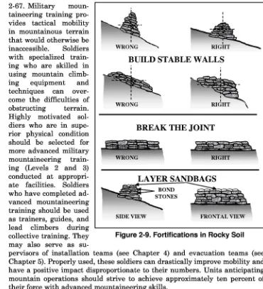
2-67. Military moun-taineering training pro-vides tactical mobility in mountainous terrain that would otherwise be inaccessible. Soldiers with specialized train-ing who are skilled in using mountain climb-ing equipment and techniques can over-come the difficulties of obstructing terrain. Highly motivated sol-diers who are in supe-rior physical condition should be selected for more advanced military mountaineering train-ing (Levels 2 and 3) conducted at appropri-ate facilities. Soldiers who have completed ad-vanced mountaineering training should be used as trainers, guides, and lead climbers during collective training. They may also serve as
su-pervisors of installation teams (see Chapter 4) and evacuation teams (see Chapter 5). Properly used, these soldiers can drastically improve mobility and have a positive impact disproportionate to their numbers. Units anticipating mountain operations should strive to achieve approximately ten percent of their force with advanced mountaineering skills.
LEVEL 1: BASIC MOUNTAINEER
~
II
~
BUILD STABLE WALLS
~
_.I~..I ~
I
WRONG
BREAK THE JOINT
~
~
~~;~\
LAYER SANDBAGS
~~:s
~
SIDEVIEW FRONTAL VIEW
Figure 2-9. Fortifications in Rocky Soil
.
Characteristics of the mountain.
Rope management and knots environment (summer and winter).
Natural anchors.
Mountaineering safety.
Familiarization with artificial.
Use, care, and packing of anchorsindividual cold weather clothing
.
Belay and rappel techniques and equipment.
Use of fixed ropes (lines).
Care and use of basic.
Rock climbing fundamentals mountaineering equipment.
Rope bridges and lowering.
Mountainbivouactechniques systems.
Mountain communications.
Individual movement on snow and.
Mountain travel and walking icetechniques
.
Mountain stream crossings (to.
Hazard recognition and route include water survival techniques)selection
.
First aid for mountain illnesses.
Mountain navigation and injuries.
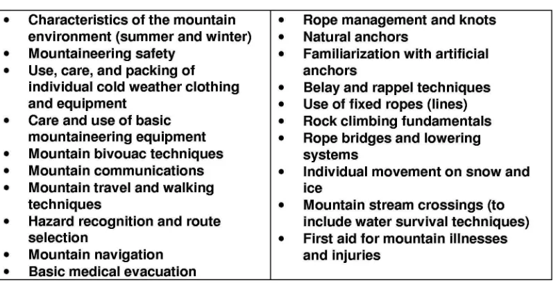
Basic medical evacuationmountaineer should be capable of performing duties as the "follower" or "sec-ond" on a roped climbing team, and should be well trained in using all basic rope systems. These soldiers may provide limited assistance to soldiers un-skilled in mountaineering techniques. Particularly adept soldiers may be se-lected as members of special purpose teams led and supervised by advanced mountaineers. Figure 2-10 lists the minimum knowledge and skills required of basic mountaineers.
Figure 2-10. Level 1: Basic Mountaineer Tasks
2-69. In a unit training program, level 1 qualified soldiers should be identi-fied and prepared to serve as assistant instructors to train unqualified sol-diers in basic mountaineering skills. All high-risk training, however, must be conducted under the supervision of qualified level 2 or 3 personnel.
LEVEL 2: ASSAULT CLIMBER
2-70. Assault climbers are responsible for the rigging, inspection, use, and operation of all basic rope systems. They are trained in additional rope man-agement skills, knot tying, belay and rappel techniques, as well as using spe-cialized mountaineering equipment. Assault climbers are capable of rigging complex, multipoint anchors and high-angle raising/lowering systems. Level 2 qualification is required to supervise all high-risk training associated with LevelL At a minimum, assault climbers should possess the additional knowledge and skills shown in Figure 2-11 on page 2-22.
LEVEL 3: MOUNTAIN LEADER
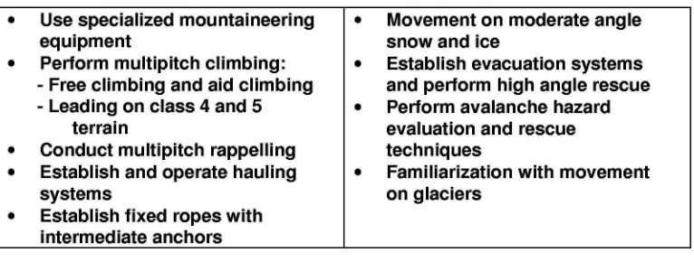
.
.
Movement on moderate angle snow and iceEstablish evacuation systems and pertorm high angle rescue Pertorm avalanche hazard evaluation and rescue techniques
Familiarization with movement on glaciers
.
Use specialized mountaineering equipment
Pertorm multipitch climbing: - Free climbing and aid climbing - Leading on class 4 and 5
terrain
Conduct multipitch rappelling Establish and operate hauling systems
Establish fixed ropes with intermediate anchors
.
.
.
.
.
.
Figure 2-11. Level 2: Assault Climber Tasks
exposed terrain. The mountain leader is the highest level of qualification and is the principle trainer for conducting mountain operations. Instructor expe-rience at a military mountaineering training center or as a member of a spe-cial operations forces (SOF) mountain team is critical to acquiring Level 3 qualification. Figure 2-12 outlines the additional knowledge and skills ex-pected of mountain leaders. Depending on the specific AO, mountain leaders may need additional skills such assnowshoeing and all-terrain skiing.
Figure 2-12. Level 3: Mountain Leader Tasks
DRIVER
TRAINING
2-72. Driving in mountains is extremely difficult. To be suc-cessful, drivers must know their equipment's limitations and ca-pabilities. Training should cen-ter on practical exercises in mountainous terrain that gradually introduce drivers to more complex terrain and weather conditions. The exact nature of the mountainous ter-rain determines the training (see Figure 2-13).
.
Identification and recognition of potential dangersMovement along steep grades combined with:
- Narrow roads and sharp curves - Loose rock and gravel
- Ice and snow (to include using tire chains for wheeled vehicles) - Towed loads
Increased cold weather maintenance requirements
.
.
ARMY AVIATION
2-73. The mountainous environment, particularly its severe and rapidly changing weather, affects aircraft performance capabilities, accelerates crew fatigue, and influences basic flight techniques. These techniques can be ac-quired only through a specific training program for the particular type of mountainous terrain. Additionally, limited visibility operations in the moun-tains are extremely hazardous and require extensive training for those avia-tion units involved. Common problems associated with mountain operations become much more complex at night, even when using night vision devices. Few Army aviation units regularly train for mountain operations, so it is critical to alert them as soon as possible to facilitate the required training to ensure safe and successful mission execution.
RECONNAISSANCE
AND SURVEILLANCE
2-74. Training in reconnaissance and surveillance should focus on traffica-bility (route, mobility, and bridge classification), potential drop zones or landing areas, likely defensive positions, and potential infiltration routes. In-filtration and exfiltration are relatively easy in mountainous terrain and con-stitute a significant threat to the maneuver elements and their support units.
TEAM DEVELOPMENT
2-75. The decentralized nature of mountain combat and the need for the ex-ercise of a mission command philosophy of command and control involve as-signing missions to independently operating small teams that may be isolated from their higher headquarters. The disruptive influences of the environment and sustained physical stress further increase the perception of isolation (see FM 4-02.22). The most important factor that sustains a soldier in combat is the powerful psychological support that he receives from his primary group, such as a buddy team, squad, or platoon. He is less likely to feel the stress of loneliness under the isolated conditions of mountain warfare if his primary group maintains its integrity.
Chapter 3
Firepower and Protection of the Force
~~~
-
"-~
,.,.'"~""",III '~"
'''-' :'
f,,,..', ,
JII"..."~ 1M . , .
,-" /" ""'HI.I:dJ' "'~~;
. -.
/
oJ?' /' '"'"..~,'- .~
- ..,~'
;/
v.' (' '..,4'"'" /J,I'J
r .'
.-' // I
Employing fire support systems, which are an integral part of maneuver, is included in this chapter. This arrangement, however, does not suggest any change in the close doctrinal relationship between fires and maneu-ver during mountain operations.
SECTION I - FIREPOWER
FIELD ARTILLERY
3-1. The basic tactical principles for artillery remain valid in mountains, subject to the limitations imposed by terrain and weather.
MOVEMENT AND POSITIONING
3-2. Rugged terrain and reduced mobility increase the reliance on field ar-tillery fire support. However, the employment and positioning of field artil-lery systems may be severely impacted by the extreme difficulty of ground mobility in mountainous terrain. Self-propelled artillery is often limited to traveling on the existing
road and trail networks and positioning in their immediate vicinity. Towed field artillery is usually more maneuver-able; it can be brought into position with the aid of trucks, tractors, and fixed or rotary-winged aircraft. Therefore, gun crews should be
CONTENTS
Section I - Firepower 3-1
Field Artillery 3-1
Mortars 3-5
Air Support 3-6
Electronic Wartare 3-7
Section 11- Protection of the Force 3-7
Air Defense Artillery 3-7
Eng ineer Operations 3-9
NBC Protection 3-10
proficient in equipment-rigging techniques and air assault procedures, and possess ample sling-load equipment. Field artillery emplaced by helicopter normally requires continued airlift for subsequent displacement and ammu-nition resupply, and often necessitates substantial engineer support.
3-3. Light field artillery may require forward displacement of gun sections by helicopter to provide forward troops the necessary support. Medium field artillery may give the longer range required, but may be limited by high-terrain crest clearance. Normally, field artillery is employed far enough to the rear to take advantage of increased angles of fall. Flat areas, such as dry riv-erbeds, villages and towns, and farmland, can usually accommodate firing units, however, these positions present particular problems in the mountains for the following reasons:
.
Dry riverbeds are hazardous because of the danger of flash flooding..
Towns and villages usually have adequate flat areas such as parks,schoolyards, and playing fields but they are relatively scarce and of-ten targeted by the enemy.
.
Farmland is often difficult to negotiate from spring to fall. In the win-ter, if the ground is frozen, farmland may provide good firing posi-tions; however, frozen ground may cause difficulty emplacing spades, base plates, and trails.3-4. Good artillery positions, selected for cover, flash defilade, and accessi-bility to road nets and landing zones (LZs), are difficult to find, and their rela-tive scarcity makes it easier for the enemy to target probable locations. In some instances, it may be necessary to by-pass the best position for one less suitable to reduce the enemy's counterfire effects. Commanders must ensure that positions on dominant terrain provide adequate defilade. Positions on commanding terrain are preferable to low ground positions because there
is-.
A reduction in the number of missions requiring high-angle fires..
A reduced amount of dead space in the target area..
Less exposure to small arms fire from surrounding heights..
Less chance of being struck by rockslides or avalanches.Chapter 3
ACQUISITION AND OBSERVATION
3-6. Because of high angle fire requirements, radar can be effective against enemy indirect fire systems. In many instances, terrain masking and dimin-ished line-of-sight may degrade its effectiveness. Sites should be selected on prominent terrain to obtain the lowest possible screening crest. However, it is often difficult to obtain a low and consistent screening crest in mountainous terrain. Too Iowa screening crest drives the search beam into the ground. Too high a screening crest allows the enemy to fire under the beam and avoid de-tection. When positioning weapons locating radars, commanders should also consider the following:
.
Although time-consuming, visibility diagrams are extremely useful in determining the probability of acquiring targets within the sectors of search of the radar..
To limit search areas, radars should focus on terrain that can be oc-cupied by artillery and mortars..
Accurate survey control is essential because of the extreme elevation variations in mountainous terrain. Helicopters may be useful in per-forming survey by use of the Position Azimuth Determining System (PADS). If possible, digital radar maps may be used to minimize the time required for height correction of the weapon system. Digital maps allow the Firefinder systems to initially locate weapon systems to within 250 meters. This allows the radar operator to make only two to three visual elevation adjustments to accurately locate the weapon system..
Impact predict is computed at the radar's elevation, therefore, exces-sive errors in the impact predict can be expected..
Firefinder radars in the same area must not face one another and ra-diate at the same time. This causes interference and emissions burn-out, resulting in equipment failure. If radars need to face one another to accomplish the mission, commanders must coordinate to ensure that they do not radiate at the same time..
Computing track volume may become a critical task in determining a radar's effectiveness for a proposed position (see FM 3-09.12 for com-putations)..
Units will use more shelling reports (SHELREPs) to determine enemy firing locations.3-7. The majority of all field artillery fires in mountains will be observed, es-pecially close support and defensive fires. Unobserved fires are frequently unreliable because of poor maps and rapidly changing meteorological condi-tions that cause registration corrections for high angle fire to be valid for only short periods of time.
TARGETING
3-8. Generally, field artillery observation posts should be emplaced on the highest available ground to increase observation. Low clouds or fog may re-quire moving them to preplanned emplacements at lower elevations. Observ-ers must be prepared to perform assault climbing to reach the most advanta-geous observation site. Commanders may use aerial observers or unmanned aerial vehicles (DAVs) to detect long-range targets and complement forward observers by adjusting fires beyond terrain masks, in deep defilade, and on reverse slopes. However, in extremely high mountains aerial observers may be confined to valleys and lower altitudes due to altitude limitations on dif-ferent types of aircraft.
3-9. Laser weapons demand increased emphasis on observation techniques. Laser target ranging and designation systems help to overcome difficulties in range estimation by providing accurate directional distance and vertical an-gle information for use in locating enemy targets. However, when positioning with a laser designator, an observer should consider line-of-sight with the target, as well as cloud height. Cloud ceilings that are too low will not allow laser guided munitions enough time to lock on and maneuver to the target.
3-10. Because of the decentralized nature of mountain operations, targets warranting massed fires may present themselves less often than in open ter-rain. However, narrow defiles used as routes of supply, advance, or with-drawal by the enemy are potentially high payoff targets for interdiction fires or large massed fires. Large masses of snow or rocks above enemy positions and along main supply routes are also good targets, because they can be con-verted into highly destructive rockslides and avalanches that may deny the enemy the use of roads and trails, and may destroy elements in defilade. In the mountains, suppression of enemy air defenses takes on added importance because of the increased dependence on all types of aircraft. Commanders and their staffs should carefully review FM 3-60. A clear understanding of the targeting methodology combined with the knowledge of the capabilities and limitations of target acquisition and attack systems in a mountain envi-ronment is crucial to the synchronization of all available combat power.
3-11. To provide accurate and timely delivery of artillery fires in mountainous terrain, commanders must take into account the following:
.
High angles of elevation and increased time of flight for rounds to im-pact.Chapter 3
MUNITIONS
MORTARS
.
When the five requirements for accurate predicted fire (target loca-tion and size, firing unit localoca-tion, weapons and ammunition informa-tion, meteorological information, and computational procedures) are not achievable, registration on numerous checkpoints becomes essen-tial because of the large variance in elevation (see FM 3-09.40 for more detailed information).3-12. Terrain and weather also affect the use of field artillery munitions. Con-siderations for munitions employment in the mountains are discussed below.
.
Impact fuze, high explosives (HE) shells and dual-purpose improved conventional munitions (DPICMs) are very effective on rocky ground, scattering stones and splintering rocks, which themselves become missiles. However, deep snow reduces their bursting radius, making them approximately 40 percent less effective. The rugged nature of the terrain may afford added protection for defending forces; there-fore, large quantities of HE may be required to achieve the desired ef-fects against enemy defensive positions..
Variable time (VT) or time fuzes should be used in deep snow condi-tions and are particularly effective against troops on reverse slopes. There are some older fuzes that may prematurely detonate when fired during heavy precipitation (M557 and M572 impact fuzes and M564 and M548 time fuzes)..
Smoke, DPICM, and illuminating fires are hard to adjust and main-tain due to swirling, variable winds and steep mountain slopes. Smoke (a base-ejecting round) may not dispense properly if the canis-ters become buried in deep snow. In forested mountains, DPICMs may get hung up in the trees. These types of munitions are generally more effective along valley floors..
Using the artillery family of scatterable mines (FASCAM) and Cop-perhead is enhanced when fired into narrow defiles, valleys, and roads. FASCAM may lose their effectiveness on steep terrain and in deep snow. Melting and shifting snow may cause the anti-handling devices to detonate prematurely the munitions, however, very little settling normally occurs at temperatures lower than 5 degrees Fahr-enheit. Remote antiarmor mine system (RAAMS) and area denial ar-tillery munitions (ADAM) must come to rest and stabilize within 30 seconds of impact or the sub munitions will not arm, and very uneven terrain may keep the ADAM trip wires from deploying properly.3-13. Mortars are essential during mountain operations. Their high angle of fire and high rate of fire is suited to supporting dispersed forces. They can deliver fires on reverse slopes, into dead space, and over intermediate crests,
and, like field artillery, rock fragments caused by the impact of mortar rounds may cause additional casualties or damage.
3-14. The 60mm mortar is an ideal supporting weapon for mountain combat because of its portability, ease of concealment, and lightweight ammunition. The 81mm mortar provides longer range and delivers more explosives than the 60mm mortar. However, it is heavier and fewer rounds (usually no more than two per soldier) can be man-packed. The 120mm mortar may be more desirable in some situations, since they can fire either white phosphorous (WP) or HE at greater ranges than lighter mortars and have a significantly better illumination capability.
However, because of the weight of these mortars and their ammunition, it may be necessary to transport fewer of them into mountainous terrain and use the remaining gun crews as ammunition bearers, or position them close to a trail network in a valley or at lower elevations. The second technique may be satisfactory if the movement of the unit can be covered and sufficient firing positions exist.
AIR SUPPORT
3-15. Air interdiction and close air support operations can be particularly ef-fective in mountains, since enemy mobility, like ours, is restricted by terrain. Airborne forward air controllers and close air support pilots can be used as valuable sources of information and can find and designate targets that may be masked from direct ground observation. Vehicles and personnel are par-ticularly vulnerable to effective air attack when moving along narrow moun-tain roads. Precision-guided munitions, such as laser-guided bombs, can quickly destroy bridges and tunnels and, under proper conditions, cause landslides and avalanches to close routes or collapse on both stationary and advancing enemy forces. Moreover, air-delivered mines and long-delay bombs can be employed to seriously impede the enemy's ability to make critical route repairs. Precision-guided munitions, as well as fuel air explosives, can also destroy or neutralize well-protected point targets, such as cave entrances and enemy forces in defilade.