A SURVEY OF UNICAST ROUTING PROTOCOLS
BASED-GREEDY FORWARDING STRATEGIES FOR VEHICULAR
AD–HOC NETWORKS IN URBAN SCENARIO
MOHAMED SAAD BOBA,SULAIMAN MOHD NOR,SAMI ABBAS NAGAR
Faculty of Electrical Engineering, Universiti Teknologi Malaysia, Malaysia
E-mail: [email protected] , [email protected] ,[email protected]
ABSTRACT
A vehicular ad hoc network (VANET) is a new technology that allows vehicles to form a self-organized network without reliance on permanent infrastructure. The characteristics of VANET such as rapid topology changes, high mobility, and frequent link disconnections makes it difficult to design an efficient routing protocol for routing data among vehicle to vehicle communication (V2V). Existing greedy routing protocols for VANET are not efficient to meet every traffic scenario such as low traffic densities. There are large numbers of surveys that have studied different greedy routing protocol categories. We select a limited, but representative number of these surveys to be reviewed in our work. This survey intends to provide a comprehensive review of these categories of greedy routing protocols. In this paper we provide a survey of greedy routing protocols for a vehicular ad-hoc network, and present a timeline of the development of existing greedy routing protocols. Wediscuss the advantages and disadvantages of these routing protocols and define some current issues and possible directions of future research related to using greedy routing protocols. Finally, weinvestigate and compare several greedy algorithms designed for urban VANET. A qualitative comparison of these approaches can serveas a guideline for network designers to choose appropriate greedy routing protocols to meet network application objectives.
Keywords: Vehicular Ad Hoc Network V2V Communication, Urban Scenario, Forwarding Strategy, Greedy Routing Protocol.
1. INTRODUCTION
Vehicular ad-hoc network (VANET), a subclass of mobile ad-hoc networks (MANETs), is used to provide communication between vehicles. They are self-organized networks in which vehicles communicate with each other without the need for centralized administration to reduce the deployment costs. VANETs have several applications; they can be used to improve road traffic safety and efficiency with real time information about the status of the road conditions[1]. A VANET is a core element in the development of Intelligent Transportation System (ITS) applications[2]. The main goal of ITS is to support vehicular safety by providing the right information related to road and traffic conditions to drivers. In VANET, vehicles move non-randomly along road and exchange information with other vehicles and roadside infrastructure within the radio range. In general, communications in a VANET are divided into three categories. First, vehicle to infrastructure (V2I) can provide real-time information on road traffic
conditions, weather conditions, and basic internet service via communication with backbone networks. Second, Vehicle-to-Cloud Communication is type of communication, useful for many applications and expands driver assistance and vehicle in network fleet management. Third, vehicle to vehicle (V2V) communication is a special type of ad hoc networks that can be used to provide communication environments between vehicles and exchange of data by multi-hop communication to othersb through on-board units (OBUs) without any fixed infrastructure [3].
bandwidth and self-organization.These characteristics can affect performance of routing dramatically. Numerous routing protocols proposals in MANETs such as, AODV [5], DSR [6] and OLSR [7] are not suitable for VANET because of the unique characteristics of VANETs. These protocols cannot be directly applied in VANETs efficiently, since the results may lead to increased control overhead and delay. In a comparative study of VANET routing protocols [8], there are two class routing algorithms: position based-greedy V2V protocols and delay tolerant protocols. The challenging mobility problems in urban environments make routing protocol a very important task in VANET. To remedy this problem, greedy forwarding algorithm is the first suitable solution that have been proposed for VANETs because it maintains only local information of neighbors to make routing decisions.
Our main contribution in this work is that we select some well-known greedy routing protocols and study their strengths and weakness. The objectives of this paper include the following: to highlight the advantages and disadvantages of greedy routing protocols, to discuss current issues as well as possible directions of future research related to greedy forwarding strategy, and to investigate and compare several greedy algorithms designed for urban VANET.
This paper is organized as follows: Section 2 describes the characteristics of city scenarios and vehicular ad hoc networks. It also explains the types of forwarding strategies used in vehicular networks. Section 3 describes the timeline of greedy routing protocols. Section 4, provides on of the position based-greedy V2V protocols. Section 5, comparisons and analysis of the protocols. Section 6, conclusion.
2. BACKGROUND
The characteristics of forwarding strategies VANETs makes vehicular communication much more challenging. Some of the characteristics and forwarding strategies are described below
2.1 Characteristics of VANETs
VANET provides communication services between intelligent vehicles or with roadside infrastructure. VANETs have unique characteristics with MANETs, such as multi-hop communication between mobile nodes and limited bandwidth. This unique characteristics should be considered when
designing a routing protocol [9, 10]. VANET has constrained mobility of nodes and the topology of VANET is always changing. This affects the performance of routing protocol dramatically. Routing protocol has greater challenges in VANETs because of the rapid movement of vehicles and frequent changes in the topology of VANETs. VANETs has many similarities to ad hoc networks, but differs from other kind of ad hoc networks in the following aspects.
a) High mobility with the constraint of road topology. The vehicles are always moving at high speeds and non-randomly along roads.
b) Rapidly changing network topology. Due to the high speeds of movement between vehicles, the network topology in VANETs tends to change frequently. c) Geographical type of communication.
Most applications in VANETs require identification of the vehicles in a certain region, instead of the specific vehicles. Compared to other networks, VANETs often have a new type of communication which addresses a geographical area where packets need to be forwarded (e.g., in safety deriving applications).
d) Time-sensitive data exchange (delay). Most safety-related applications require data packet transmission in a timely manner. Thus, no security schemes can harm the network performance of VANETs.
e) Potentially unbounded network size. The network is a very open environment; VANETs could involve the vehicles in one city, several cities, or even a country. Thus, it is necessary to make any protocols for VANETs scalable in order to be practical.
f) Effect of obstacles (i.e. buildings). In VANETs, node moving (vehicles) is restricted by predefined infrastructure like tracks or roads. In situations whereroads are surrounded by tall buildings or trees; radio waves may not be able to pass through such obstacles thereby preventing vehicles-to-vehicle communication. g) Various communications environments.
2.2 Forwarding Strategies of Vehicular Networks
Generally, geographic routing protocols for VANET employ various strategies for forwarding i.e. greedy, opportunistic and trajectory-based strategies. Basically, geographical based-forwarding strategy is able to overcome the limitations of topology based routing protocols for identifying the accurate positions. This limitations can be eliminated by using various forwarding strategies than traditional forwarding messages. Forwarding strategies can be divided into three categories for position-based routing protocols. These as 1) restricted directional flooding; 2) hierarchical forwarding; and 3) greedy forwarding. The primary objective of broadcasting in VANETs is to distribute information from one source to many unknown/unspecified destinations. The advantage of this is a more reliable data transmission with less packet loss.However, this might lead to greater bandwidth consumption, network congestion and more packet delay. In [9], restricted directional flooding is proposed based on broadcast-based protocols such as mobility-centric data dissemination algorithm for vehicular networks (MDDV), which exploits geographic forwarding to the destination region with consideration for high density. MDDV calculates the forwarding trajectory to the destination region, and the closest vehicles to the destination within the forwarding trajectory participate in group forwarding. Second, hierarchical forwarding combines two routing classes [10],one for node in surrounding area (terminodes local routing) and one for routing over large distances (terminodes remote routing). In addition,these two of forwarding strategy implements for protocol such as geodesic packet forwarding (GPF) and anchored GPF schemes. However, as mentioned above, these forwarding strategies are inadequate for dealing in urban environment.
Greedy forwarding strategy is the first algorithm for dealing with the high dynamic topology in VANETs, and is mainly proposed for urban environments to avoid the limitation of other forwarding strategies in VANETs. However, this type of strategy fails to deliver data packet successfully to the destination because of vehicle characteristics and city scenarios. There are several works that investigate routing protocols in VANETs adopting greedy forwarding. The key advantages of using a greedy forwarding strategy
adapts well to frequent changes of the network topology, compared with broadcast-based protocols and hierarchical approach. However, we note certain weaknesses in previous works. For an example is greedy perimeter stateless routing [11], which is based on simple greedy forwarding concept (the closest vehicle to the destination). The drawback of this protocol is that it does not take into account the urban environment characteristics. This might lead to weak signal reception caused by radio obstacles such as building, trees, and vehicles. Simple greedy forwarding based geographical routing protocol is the first type of greedy approach based on the concepts by [12].The intermediate node forwards the packet to the farthest node, those its neighbours towardto node closest to the destination. Since all the decisions are taken based on directly connected neighbors’ positions, there is a high possibility of local maximum problem. However, the packet can make maximum progress towards its destination; but failsto overcome local maximum problem. So, farthest node leads to poor signal reception because of the obstacles, but at the same time reducing the number of hops.
The second type of greedy approach is called restricted greedy forwarding. It works well in city environments than simple greedy forwarding, it can also adapt to different topology scenarios including highway and city. Restricted greedy forwarding is used in city environments, because there is no hinderance todirect communication between nodes due to obstacles such as buildings, vehicles, and trees [13]. However, these approach isonly based on the existence of a priority node in the center of the junction. If the vehicles move slow or do not move at all, the vehicle the center of a junction remains the same and receives all the traffic and thismay lead to communication bottlenecks. Another type of restriction-based approachuses highest direction priority of neighbours moving toward the destination or toward the next junction to forward packet. It is called improved greedy [14]. Though this approach is more suitable than some others as mentioned above, it still suffers from the challenge of choosing the next junction when other adjacent road have no vehicles and the packet has to travel back on the same road.This approach might lead to error and inaccurate traffic density estimation.
moving towards a destination. However, this strategy might lead to increase overhead
3. TIMELINE OF GREEDY ROUTING PROTOCOLS
In this section, our studies are focused on greedy routing protocols. We present a timeline of the greedy routing protocols for VANETs and the potential influence on each other. Figure 1 shows the timeline of the greedy routing protocols according to their publication dates, and which protocols have been affected by others.
Figure1. Timeline Of The Greedy Routing Protocols For Vanets And Potential Influence Between Them.
4 Overview of Protocols
4.1 Position–based Greedy V2V Protocols Unicast routing protocols refer to information delivery from a single source to a single destination using the wireless multi hop data delivery. Many number of unicast routing protocols used a position-based greedy forwarding strategy to provide vehicle -to- vehicle communication. A position-based approach uses information about the geographic coordinates or relative positions of nodes to generate an efficient route through the network. Geographical routing protocol needs a greedy forwarding strategy to deal with frequently changing topology due to high mobility and network disconnections. Greedy forwarding aims to forward data packets to a destination, and between intersections or between vehicles on the road in the various scenarios. For example, a node forwards a packet to a neighbor that is located closer to the destination. It exploits global information about the geographic coordinates or neighbor’s position of
nodes to generate an efficient route through the networks.
4.1.1 Greedy Perimeter Stateless Routing (GPSR)
In [11] the authors proposed Greedy Perimeter Stateless Routing (GPSR) as the first position-based routing protocol that utilizes the positions of the vehicles and the location of the packet’s destination when making forwarding decisions. GPS device is used to obtain position of packet destination and next candidate which make correct forwarding decision. It consists of two methods, a greedy forwarding strategy and recovery strategy, greedy forwarding is used to forward packets to nodes that are always closer to the destination, while the recovery strategy is used when the greedy strategy fails to find neighbors’ node closer to the destination. GPSR only maintains location information of all of its 1-hop neighbors. The key advantages of GPSR isin its greater scalability in pre-router state than shortest path ad hoc routing protocols. However, the simple greedy strategy may lead to inadequate selection of nodes, and sometimes selecting the node closer to the destination is not the optimal node due to urban conditions. In addition, this protocol does not take into account velocity and direction of vehicle when selecting next hop closer to the destination.
4.1.2 Geographical Source Routing Protocol (GSR)
path between the source and destination based on a distance metric. However, the shortest path including junctions is not always the best path to the destination, since it does not consider vehicular traffic density on the street.
4.1.3 Spatially Aware Packet Routing (SAR)
Similar to GSR, the spatially aware packet routing (SAR) [15] is the first protocol to use spatial awareness for packet forwarding. It also attempts to overcome some of the limitations of the recovery strategy used by GPSR. SAR algorithms consist of GSR and the GSR-based packet forwarding. In SAR a node determines its location on the spatial model. Based on the spatial model, a source node can predict static topology holes caused by spatial constraints, like road geometry and layout of the implemented network. Street information is used to calculate the shortest path between sources to destination. Instead of Dijkstra algorithm, SAR depends on the extraction of a static street map from an external service such as GIS (Geographic Information Systems) to construct a spatial model for unicast routing protocol. Where a node needs to forward a packet, it inspects the packet header for the next geographic location in the route, rather than utilizing a strictly greedy strategy toward the destination, a neighbor that is located along the route listed in the packet is chosen. In SAR, forwarding packets done by, selecting a neighbour that is located along the route listed. When a forwarding node cannot find a node along the predetermined routing path in SAR, SAR employs two forwarding strategies to find a node located along the routing path.The first strategy called suspension buffer is used to stabilize the packet until a suitable node is located along the routing path.For the second, a node can attempt to greedily forward a packet towards its destination. However, the first strategy might lead to high delay, and inaccurate neighbors’ information due to out of date, vehicular traffic density does not consider in order to perform an accurate routing decision.
4.1.4 Spatial and Traffic Aware Routing (STAR)
Spatial and Traffic Aware Routing [16] is a position-based routing algorithms. STAR is designed to overcome the drawback of SAR algorithm. The features of the SAR is its underlying spatial model, allowing it to forward packets along streets. The drawback is that it does not exploit knowledge of whether any vehicles were actually positioned along the streets it selected. STAR able
to exploit both street topology information achieved from geographic information system and information about vehicular traffic in order to perform accurate routing decisions. Moreover, streets with queues of vehicles should be preferred, as they provide several alternatives for packet forwarding, thus minimizing the risk of a packet reaching a local maximum. By contrast, the routing algorithm must avoid streets where vehicles do not exist, because packets cannot be routed over them as long as their status do not change. The routing and forwarding component of the STAR computes routes on-demand by exploiting information from the node's traffic-table. Each node periodically broadcasts a beacon to its neighbors that contains sender identifier information, sender coordinates, and vehicular traffic conditions it has in its traffic table. Each node dynamically maintains a weighted graph of street map and traffic information. In SAR a source node computes the shortest path to destination using Dijkstra algorithm based on graph. Advantage of STAR fixed packet header length and a route that can be adjusted dynamically to accommodate accurate local traffic information. However, STAR only forward packets along the street that are occupied by vehicles, and traffic density is ignored. Each node periodically broadcasts a beacon message to its neighbors, and may introduce scalability and wasted bandwidth problems since there appear to be no heuristics for adapting the beacon to conditions such as high node density or network congestion.
4.1.5 A Reliable Inter-Vehicular Routing Protocol for Vehicular (RIVER)
leads to high delay, and also active traffic monitoring mechanism might lead to increase overhead.
4.1.6 Anchor-based Street Traffic Aware Routing (A-STAR)
Greedy-based position routing protocol, Anchor-based Street Traffic Aware Routing (A-STAR) [12] is designed for vehicle-to-vehicle communication. It ensures high connectivity in packet delivery by using vehicular traffic city bus information for an end-to-end connection even in low vehicular traffic densities. This algorithm improves upon GSR by taking into account the vehicular traffic on the street, but it suffers from the problem of connectivity on some sections of streets, and also use static vehicular information based on city bus route to find a path from source to destination among radio obstacles. A-STAR, depends on the calculation of a full path to forward data although using a different approach than GSR, then source node calculates the road path (Anchor Path) by a Dijkstra shortest path weighted and number of bus lines that pass through each road and simple greedy forwarding strategy along the path. In A-STAR a simple greedy forwarding strategy is used to forward data packet between two junctions, and selecting next neighbors on street as next hop rather than the farthest neighbour along a street for a next hop. If a local- maximum occurs, the recalculation path is used instead of using a recovery strategy. This algorithm used recalculation the path when the local maximum occurs the node marks the road as out-of-service and recalculates a new road path to destination from the current position. However, during data packet forwarding this protocol does not take into account velocity and direction of the next vehicle. Thus, the selected vehicle chosen to forward data packet might not be the best choice.
4.1.7 Greedy Perimeter Coordinator Routing (GPCR)
The routing protocol mainly focused on the decision-making process of data delivery at each intersection based on priority node. Despite the improved greedy routing strategy, the risk remains that a packet may get stuck in a local maximum. The simplest, thougheffective, forwarding solution is the greedy forwarding, which is used by [13]. The authors proposed Greedy Perimeter Coordinator Routing (GPCR) is a geographical routing protocol designed to deal with city environments. The algorithm improves upon GSR by removing the requirements of an external static street map for its operation.The advantages also
include the fact that it does not require any global or external information such as static street map. GPCR,based on the idea of forwarding data packet using restricted greedy strategy, and adjusts the routing path by the recovery strategy. In GPCR, junctions are the only places where actual routing decisions are made.A coordinator is always preferred over a non-coordinator to make decision. By using the correlation coefficient approach for coordinator determination, the algorithm can avoid any dependency on an external street map. However, GPCR forwards data packet based on the node density of adjacent roads and the connectivity to the destination. Thus, if the density of nodes is low or if there is no connectivity to the destination, increased delay time, and local maximum problem is still unresolved.
4.1.8 Improved Greedy Traffic-aware Routing Protocol (GyTAR)
4.1.9 Improved Greedy Traffic-aware Routing Protocol (GyTAR)
In [18] the authors proposed Improved Greedy Traffic-aware Routing Protocol (GyTAR). It is a new intersection-based geographical routing protocol capable of finding robust routes within city environments. It is unlike GSR and A-STAR, where the sender statically computes a sequence of junctions that the packet has to traverse in order to reach the destination. This algorithm improves upon A-STAR and GSR by eliminating fixed junction selection mechanism. It consists two modules. First, junction selection mechanism through which a packet must pass to reach its destination, and used an improved greedy forwarding mechanism between two junctions. It considers two modes of operation; routing at the intersections and at road segments. GyTAR considers traffic density variations and the distance to the destination, and neighbours are selected by reactivily. The idea is that, the decentralized computation for traffic density information called Infrastructure-Free Traffic Information System (IFTIS) is used to collect vehicular traffic density between two junctions and an improved greedy is used forwarding to forward data packets between two junctions. The drawback of this algorithm lies ininaccurate traffic density estimates, because the number of vehicle in the direction is ignored. Furthermore, GyTAR distributed local density estimates are based on clusters and only the cluster head Cell Density Packet (CDP) arrives at the intersection. However, maintenance of the clusters is hard and is atthe expense of network bandwidth, due to high mobility network in VANET. In reality, city map have irregular shapes such as unequal road segments between intersections.GyTAR does not consider variations of segment lengths within urban environments.
4.1.10 Enhanced Greedy Traffic-aware Routing Protocol (E- GyTAR)
This is another improvement of greedy traffic aware routing protocol in city environments by [19]. E-GyTAR is based on the idea of dynamic junction selection mechanism with consideration for the number of vehicles in the direction of the destination and curivmetric to destination. It is different from existing junction selection approaches or fixed junction selection. The basic behaviour of E-GyTAR is similar to GyTAR, but it selects junction based on the higher number of vehicles moving in the direction of destination. Selection of the next junction is without consideration for the direction of vehicles which
may lead to increased possibility of a looping route. The GyTAR doesn’t take into consideration the number of vehicles in the direction when selecting next junction durning process. As a result, GyTAR can select the junction which has higher traffic density but vehicles move opposite to direction of destination, which might lead to high delay. The intermediate junctions in E-GyTAR are chosen dynamically one by one similar to GyTAR, and an improved greedy forwarding mechanism between two junctions. Each vehicle maintains a neighbor table in which the position, velocity, and direction of each neighbor vehicle are recorded. However, unlike GyTAR, E-GyTAR forwards data packets based on number of vehicle in the direction of destination and traffic density. This approach does not consider whether or not there are enough vehicles in the direction of destination at different lanes. Group leaders is only update once which might lead to inaccurate traffic density estimation on road.
4.1.11 Contention Based Routing Protocol (CBRP)
Contention based routing protocol (CBRP) [20] is proposed for vehicular networks in urban environments. CBRP adopts the carry and forwarding ofthe packet through wireless channel as much as possible. Recoverystrategybased carry and forward is used to forward packet where there are no suitable neighbor for packet forwarding. The key advantage of CBRP is that it does not require the node to maintain its neighbor’s location. CBRP is divided into two modes, street mode and junction mode.The street mode is operated when a packet is carried by a vehicle in the street, and junction mode is applied to determine the next junction. Contention based forwarding is used to forward the packet to the next junction. The drawback of this approach is that it only considers the real time vehicular traffic variation. The basic behaviour of CBRP is similar to GyTAR, but selecting junction s is diferent. A weight is assigned to each street based on traffic density only. However, this protocol does not take into account curvmertic distance and number of vehicle in the direction when selecting junction.
5. COMPARISON AND ANALYSIS
6 CONCLUSION
This paper presents a detailed survey of greedy routing protocols for V2V communication. Characteristics of vehicular ad hoc networks along with the forwarding strategies in the different protocols are described. This paper highlights the different position-based greedy routing protocols operable in city environments and also in open environments along with their routing issues. We provided a timeline of geographical-based greedy routing protocols for VANETs, and discusses the advantages and disadvantages of each of them. Qualitative comparison between numerous routing protocols based on their objectives, design approaches, and requirements or assumptions were alsopresented.
REFRENCES:
[1] Consortium, C.V.S.C., Vehicle safety communications project: task 3 final report: identify intelligent vehicle safety applications enabled by DSRC. National Highway Traffic Safety Administration, US Department of Transportation, Washington DC, 2005. [2] Toor, Y., P. Muhlethaler, and A. Laouiti,
Vehicle ad hoc networks: Applications and related technical issues. Communications Surveys & Tutorials, IEEE, 2008. 10(3): p. 74-88.
[3] Tse, Q. Improving message reception in VANETs. in The International Conference on Mobile Systems. In: The International Conference on Mobile Systems, Applications, and Services (MobiSys), Krakow, Poland. 2009.
[4] Ranjan, P. and K.K. Ahirwar. Comparative study of vanet and manet routing protocols.
in Proceedings of the International
Conference on Advanced Computing and Communication Technologies (ACCT 2011). 2011.
[5] Perkins, C.E. and E.M. Royer. Ad-hoc on-demand distance vector routing. in Mobile Computing Systems and Applications, 1999. Proceedings. WMCSA'99. Second IEEE Workshop on. 1999: IEEE.
[6] Johnson, D., Y. Hu, and D. Maltz, The dynamic source routing protocol (DSR) for mobile ad hoc networks for IPv4. RFC4728, 2007: p. 2-100.
[7] Clausen, T., et al., Optimized link state routing protocol (OLSR). 2003.
[8] Kohli, S., B. Kaur, and S. Bindra, A comparative study of Routing Protocols in VANET. Proceedings of ISCET, 2010.
[9] Wu, H., et al. MDDV: a mobility-centric data dissemination algorithm for vehicular networks. in Proceedings of the 1st ACM international workshop on Vehicular ad hoc networks. 2004: ACM.
[10] Hubaux, J.-P., et al., Toward self-organized mobile ad hoc networks: The Terminodes Project. Communications Magazine, IEEE, 2001. 39(1): p. 118-124.
[11] Karp, B. and H.-T. Kung. GPSR: Greedy perimeter stateless routing for wireless networks. in Proceedings of the 6th annual
international conference on Mobile
computing and networking. 2000: ACM. [12] Seet, B.-C., et al., A-STAR: A mobile ad hoc
routing strategy for metropolis vehicular communications, in NETWORKING 2004. Networking Technologies, Services, and Protocols; Performance of Computer and Communication Networks; Mobile and Wireless Communications. 2004, Springer. p. 989-999.
[13] Lochert, C., et al., Geographic routing in city
scenarios. ACM SIGMOBILE Mobile
Computing and Communications Review, 2005. 9(1): p. 69-72.
[14] Jerbi, a., Moez, et al., An improved vehicular
ad hoc routing protocol for city
environments. Communications, 2007.
ICC'07. IEEE International Conference on, 2007: p. 3972-3979.
[15] Tian, J., L. Han, and K. Rothermel. Spatially aware packet routing for mobile ad hoc inter-vehicle radio networks. in Intelligent Transportation Systems, 2003. Proceedings. 2003 IEEE. 2003: IEEE.
[16] Giudici, F. and E. Pagani, Spatial and traffic-aware routing (STAR) for vehicular systems, in High Performance Computing and Communications. 2005, Springer. p. 77-86.
[17] Bernsen, J. and D. Manivannan, RIVER: A reliable inter-vehicular routing protocol for vehicular ad hoc networks. Computer Networks, 2012.
[18] Jerbi, M., et al. GyTAR: improved greedy traffic aware routing protocol for vehicular ad hoc networks in city environments. in Proceedings of the 3rd international workshop on Vehicular ad hoc networks. 2006: ACM.
[20] Li, T., Y. Li, and J. Liao. A contention-based routing protocol for vehicular ad hoc networks in city environments. in Distributed
Computing Systems Workshops, 2009.
ICDCS Workshops' 09. 29th IEEE
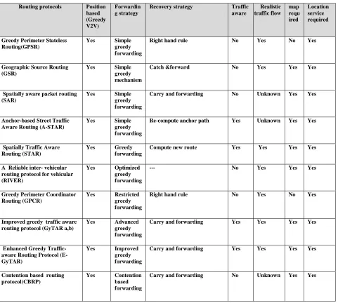
Table 1 Comparison and Analysis
Routing protocols Position based (Greedy V2V)
Forwardin g strategy
Recovery strategy Traffic aware
Realistic traffic flow
map requ ired
Location service required
Greedy Perimeter Stateless Routing(GPSR)
Yes Simple greedy forwarding
Right hand rule No Yes No Yes
Geographic Source Routing (GSR)
Yes Simple greedy mechanism
Catch &forward No Yes Yes Yes
Spatially aware packet routing (SAR)
Yes Simple greedy forwarding
Carry and forwarding No Unknown Yes Yes
Anchor-based Street Traffic Aware Routing (A-STAR)
Yes Simple greedy forwarding
Re-compute anchor path Yes Unknown Yes Yes
Spatially Traffic Aware Routing (STAR)
Yes Greedy forwarding
Compute new route Yes Yes Yes Yes
A Reliable inter- vehicular routing protocol for vehicular (RIVER)
Yes Optimized greedy forwarding
--- No Yes Yes Yes
Greedy Perimeter Coordinator Routing (GPCR)
Yes Restricted greedy forwarding
Right hand rule No Yes No Yes
Improved greedy traffic aware routing protocol (GyTAR a,b)
Yes Advanced greedy forwarding
Carry and forwarding Yes Yes Yes Yes
Enhanced Greedy Traffic-aware Routing Protocol (E- GyTAR)
Yes Improved greedy forwarding
Carry and forwarding Yes Yes Yes Yes
Contention based routing protocol(CBRP)
Yes Contention based forwarding