Studies
1. Introduction
Landscape is a comprehensive system not only organized by biological and biotic components, but which also has a certain cultural stratum and essence that play a major role in humankind’s relationship to the landscape (Dneboská 2006). Without a connection to culture we could not even consider the implications of the term landscape and would make do with the rather technical Roman term “terra”, meaning land (Lapka 2008). Each
landscape has its own specific structure, which is formed and affected by social, economic and environmental factors (Bičík, Jeleček et al. 2001; Turner, Wear et al. 1996). The structure of a landscape refers to the distribution of individual landscape components (landscape matrices, surfaces and corridors) within the landscape (Novotná 2001). It is that part of the area that is perceived by its inhabitants, whose character
A comparison of changes in landscape structures in model sections of the
D1 motorway
Keken Zden
ě
k
1*, Kušta Tomáš
2, Ježek Miloš
2, Martiš Miroslav
1 1Faculty of Environmental Sciences, Czech University of Life Sciences Prague, Kamýcká 129, Prague 6, 165 21, Czech Republic
2
Faculty of Forestry and Wood Sciences, Czech University of Life Sciences Prague, Kamýcká 129, Prague 6, 165 21, Czech Republic
Abstract
This paper examines changes in landscape structure in two areas affected by the construction and operation of the D1 motorway in the Czech Republic. The localities were selected in such a way that one of the model sections was strategically located in proximity to the capital city of Prague (section 11–29 km). The other model section was selected in the Bohemian–Moravian Highlands (section 75–87 km), i.e. its location was away from Prague. The gradual development of biotopes, and in particular their representation and size, was analysed using comparisons of historical and current aerial photographs. The development of the landscape was evaluated in section 11–29 km in 1974, in 1988 and in 2007, and in section 75–87 km it was evaluated in 1975, in 1983 and in 2007. We mainly analysed the direct occupation of biotopes, changes in the areas of agricultural and forestry lands, the construction and extension of agglomerations and accompanying commercial infrastructure. The area of interest was defined as a width of 200 m on either side from the axis of the motorway, and always along the entire section. The results show, for example, that in terms of the construction of industrial premises, the location of a section relative to Prague plays a significant role. In section 11–29 km, there were no industrial premises in 1974. Industrial premises covered 0.16% of the area in 1988, while in 2007 they occupied 8.53% of the entire area of interest. In section 75–87 km, however, the area of industrial premises remained almost unchanged. In 1975, industrial premises occupied 0.28% of the area, and in 2007 the proportion was 1% of the total area of interest. In addition, the agricultural land was drastically reduced in both sections, and the area of forest increased slightly.
Key words: Landscape, Landscape fragmentation, Barrier effect, Land use, Suburbanization.
results from the actions of natural and human factors and their mutual relationships (EUK 2000 in Löw, Míchal 2003). A basic feature of every landscape is its spatial heterogeneity, expressed by the landscape structure, which has a decisive influence on the functional properties of that landscape (Lipský 2000). In the development of relationships between humans and landscape, we must recognize the conflict between the tendency of natural processes toward maximum stability and the human objective of maximum exploitation (Šlezingr 2003). The construction and extension of a road infrastructure can also be considered as an effort toward maximizing exploitation.
Significant negative effects of road construction include direct occupation of biotopes, landscape recolonization, environmental contamination, various types of disturbance (noise, vibration, dustiness, etc.) and, of course, fragmentation. Landscape fragmentation is a serious and very complex issue in nature and landscape protection, and it can have catastrophic future consequences for fauna, flora, biotopes, and even for entire ecosystems (Anděl et al. 2005). Loss of natural habitats, decreases in surface areas, increasing isolation of habitats – these all rank among serious side-effects of landscape fragmentation. All lead to declining biodiversity within the original habitats (Andrén 1994; Burel, Baudry 2005; Fahrig 1997; Fahrig 2003).
Negative impacts of anthropogenic activities on landscape and on the landscape fragmentation rate were monitored in a study by Lebeau (2002), among others. He states that between 1978 and 1989 a natural area the size of 10 football pitches (ca 74,304 m2) disappeared in Switzerland each day for the benefit of urban structures, which is an average occupation of 0.86 m2 per second. The long-term negative trend in the development of landscape structures from the viewpoint of occupying natural habitats may also significantly affect the overall landscape stability.
Restoring a environmental functions of a landscape, or, more precisely, restabilising it after negative influences, is a relatively young scientific discipline. It was formed in the 1980s, with the aim of minimizing the impact of human activities on ecosystems and returning ecosystems to their original functions and features (Hobbs, Harris 2001; Prach 2008). The key element of recultivation is itself understood to be ecological
restoration, which is in fact the process of restoring ecosystems (del Moral, Walker 2007).
Comparisons of changes in landscape structures over time fall within the multidisciplinary field of landscape ecology. Landscape ecology began with decoding aerial photographs of landscapes to show what the structures represent, how they are arranged, and how they have changed in time (Lapka 2008). By comparing the historical character and appearance of landscapes with their current character and appearance, we are able to deduce the crucial trends in the development of landscape structures (Beneš, Brůha 1994; Gojda 2000).
Geographical information systems are important tools in analysing landscape and landscape structures, or, more precisely, the changes in landscape structure (Gergel, Turner 2002). These tools have now become very widespread, and are appropriate for various types of landscape analysis (Antrop 2000). When implementing spatial analyses in a GIS environment, historical and current aerial photographs are very often compared (Míchal 1996; Kolejka 2001). This is one of the non-destructive methods of landscape research (Gojda, 2000). An understanding of the historical context in the creation and formation of a landscape structure is of particular importance for design purposes and for practical current landscape management, which often refers back to the historical status in many respects (Trémolliéres, Schnitzler 2007).
Methods
Because the role of humanity as the crucial species has been the major factor shaping the current appearance and state of anthropogenically influenced landscapes, a historical landscape development study has been conducted and used as the basic output of landscape-ecological analysis for the areas of interest (Vitousek et al. 1997). One way to prevent this negative trend may be to create so-called compromise-use ecosystems, which will be relatively productive and at the same time relatively stable (Odum 1971).
The construction and the operation of motorways affect a wide range of environmental factors, but most of the effects apply only within a distance of several meters or tens of meters from
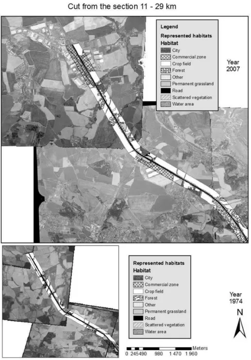
the edge of motorways or expressways (Forman et al. 1997; Forman and Alexander 1998; Forman 1999a). Based on detailed knowledge of the character of the selected sections, we established the extent of the area under direct influence of the construction and operation of the motorway as a certain polygon following the axis of the motorway to a width of 200 m on either side (see Figure 1). This includes an area that is becoming increasingly attractive for investors in commercial centres, mainly due to its excellent logistical accessibility.
Using GPS and GIS software applications, the project analyses changes in landscape structures in the area affected by a linear structure of motorway type. We quantified and analysed the macrostructure development of the landscape. Through aerial photographs, we monitored changes in landscape structures and different approaches to their management in the vicinity of the motorway. From these photographs, we compiled a time series of the landscape character development. We monitored sections 11–29 km and 75–87 km of the
D1 motorway. In section 11–29 km, the time series comprised the years 1974, 1988 and 2007. This section was selected mainly due to its strategic location near to Prague and the related assumption of strong anthropogenic pressure affecting the landscape structures in the vicinity of the linear structure. This was particularly due to structures with a linear or polygon character, which have service and production functions as “commercial centres”. In section 75–87 km, the time series comprised years 1975, 1983 and 2007. When comparing the representation of the biotopes categories in the two sections, we made a comparison of 1974 (11–29 km) and 1975 (75–87 km), of 1988 (11–29 km) and 1983 (75–87 km). For 2007 photographs from both sections were available.
The photographs were classified within a system of coordinates. A line following the middle of the motorway, or, more precisely, its axis in the length of the examined section, was added on to the layer prepared in this way. A buffer of 200 m
on either side from the axis of the motorway was created, marking out the scope of the polygon for the area of interest. In this polygon, the types of monitored biotopes were vectorized. Subsequently, their area and change in time were analysed. Thus, the gradual transformation, fragmentation and changes in the management of the landscape were studied (see Table 1).
A mutual test of observed biotopes between individual years was carried out using the Kruskal-Wallis ANOVA analysis. The non-parametric Mann-Whitney U test was used to determine the differences in the areas of each biotope between 11–29 km and 75–87 km (in each of the monitored decades).
A t-test was used to compare the total dimensions of the monitored land use categories in each year, and also the differences between the areas of each type of category for each of the monitored years in section 11–29 km and in section 75–87 km.
Results
The analysis of the time series of aerial photographs in section 11–29 km (see Figure 2) of the D1 motorway suggests that in each of the monitored periods, the Crop Field land use category always covered the largest part of the area of interest (200 metres on each side from the axis of the motorway). In 1974, Fields covered 44.24% of the area of interest, and there were no commercial centres there at that time. In 1988, commercial centres covered 0.16% of the area and the area of crop fields had increased slightly to 44.72%. At the same time, the area of forest stands had also gradually increased. The Forest category covered 16.53% in 1974, and by 1988 it had increased to more than 20%. By 2007, the Field category covered just 31% of the area of interest, although it remains the largest category. Meanwhile, the area of commercial centres grew substantially, increasing by 2007 to 8.53% of the
area. The area of forest land had increased to 21% by 2007. In the monitored area in section 11–29 km of the D1 motorway, a clearly identifiable urbanization trend can be observed in the form of suburban development of residential agglomerations, which covered 6.10% of the area in 1974, 6.86% in 1988, and 8.19% of the area in 2007.
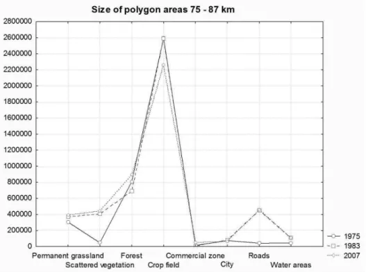
In section 75–89 km of the D1 motorway (see Figure 3), there were no such dramatic changes in the area of the land use categories as there were in section 11–29 km. In 1975, the largest part of the area of interest (55.07%) was covered by the Crop Field category. There were commercial centres on just 0.28% of the area. Forest covered 17.13% of the area of interest. Between 1975 and 1983, the area of each of the land use categories did not change substantially. The largest area (i.e. 54.78%) was still covered by Field. In 2007, the area of Fields decreased to 47.98% of the total. Commercial centres covered 1% of the analysed
area in 2007, and the Forest category occupied 18.95% of the area of interest. Between 1975 and 1883, the category of roads increased significantly, particularly due to further construction of the motorway itself.
An analysis of land use changes in the vicinity of the motorway also suggests that efforts have been made to stabilize the affected ecosystems. These efforts are manifested in practice through a gradual increase in the area of forest land and scattered vegetation (see Figure 4). This trend was observed in both sections simultaneously, and confirms that efforts have been made to mitigate the negative effect of the motorway on the affected biotopes, i.e. to balance the effectiveness of human mobility and environmental protection (Forman 2000). The most important mitigation measures in road construction are preventive measures in the pre-investment stage by designing an optimum route which respects the landscape matrix, valuable natural habitats, wetlands and the
Figure 3. Changes in land use category areas (m2) for section 75–89 km in the monitored years.
geomorphological composition of the terrain (Harris, Scheck 1991; Forman, Collinge 1997; Bennett 1999).
Using Kruskal-Wallis ANOVA, analyses of the area of biotopes in the monitored years did not reveal any significant changes in the representation of individual biotopes (H=3.790365, p=0.1503). The same result was also observed in section 75– 87 km (H=3.070869, p=0.2154). The total dimensions of the monitored land use categories were compared between the localities in the monitored years, Using the parametric t-test, it was found that a difference of p=0.0754 was recorded between 1974 in section 11–29 km and in 1975 in section 75–87 km. Between 1988 (11–29 km) and 1983 (75–87 km) there was a significant statistical difference of p=0.0064, and in 2007 there was also a significant statistical difference of p=0.0159 between the sections. This test clearly shows gradual differentiation of the biotopes, particularly in section 11–29 km, which was caused by the gradual construction of logistics centres in the vicinity of the motorway (see Figure 5).
Using the t-test, we also tested the difference in the area of the biotopes in the sections in the monitored years. A statistically significant difference was determined only in the Crop Field category, when a comparison was made of data from the 1980s (p=0.0136) and from 2007 (p=0.0040).
Conclusion
Numerous scientists have studied the restoration of original landscape functions. Various categories have been used, e.g. recultivation in a post-logging landscape (Sklenička, Kašparová 2008; Martiš et al. 2008), recultivation in a landscape affected by agricultural production (Simon, Buček et al. 2007), and ecological stabilization of the landscape in areas affected by the construction of motorways and expressways (Aanen et al. 1991; Anděl 2005; Hlaváč, Anděl 2001; Iuell et al. 2003).
Analysing the effect of the construction and operation of linear structures of motorway type on a landscape, or, more precisely, on ecosystems, is a difficult process, mainly due to challenges in estimating and determining the size of the affected area and due to the variability of the negative impacts (Martiš, Zdražil 2006). A wide range of variable factors can be identified, both regarding
the motorway (materials used, capacity, technology) and regarding the environment (landscape mosaic, differentiation of habitats, land use, terrain, prevailing wind direction, subsoil water level, etc.) (Forman, Alexander 1998; Forman, Deblinger 2000; Forman 1999b). This study has determined, described and analysed changes in landscape structures, or changes in land use, in the vicinity of the D1, which forms the road communication backbone of the Czech Republic. The study shows clearly that the land use along the D1 motorway has been changing very dynamically. In section 11–29 km, the Crop Field category, i.e. the portion of the landscape that is used agriculturally, has decreased significantly (in 1974 it covered 44.24%, while in 2007 it comprised just 31% of the area of interest). The area of commercial centres increased significantly in this section after 1989, and in 2007 this type of land use exceeded even the residential area land use (residential 8.19%; commercial centres 8.53%). The construction of commercial centres has a significant influence on the permeability and connectivity of the landscape, mainly through direct occupation of biotopes. Environmental problems are frequently due to consequences that were unintended and were difficult to predict, but this does not limit the risk appetite of companies in any way (Lapka 2008). In the case of road infrastructure development, the solution depends strongly on the nature of the spatial variability (Forman 2000).
A comparison of the areas occupied by each biotope in the two sections in the monitored years using Kruskal-Wallis ANOVA did not prove any significant change in the area of the monitored biotopes.
The changes in the areas of the monitored land use categories in section 75–89 km have not been so dramatic as those in section 11–29 km. The crop field category was reduced in the monitored period by only 7.09%, and the area of commercial centres had reached only 1% of the monitored area in 2007. This suggests that the locality which is closer to the Czech Republic’s capital city (Prague) is significantly more influenced by human activity, especially by the construction of commercial centres. This correlates directly with the reduction in the area of Crop Field biotopes.
Míchal 1992 summarizes that the ecological stabilization of an existing landscape actually
means finding a socially optimum degree of destabilization in comparison with the natural state. Our study has shown that mainly in section 11–29 km there has been a significant impact on the landscape following the construction of the motorway, due to the construction of commercial centres, making use of the strategic location (proximity to the motorway and to the capital city of the Czech Republic). The commercial centres pose a much greater risk than the motorway itself from the perspective of landscape fragmentation and the barrier effect.
References:
Aanen, P., Alberts, W., Bekker, G.J., Van Bohemen, H.D., Melman, P.J.M. 1991. Nature Engineering and Civil Engineering Works. PUDOC, Wageningen.
Anděl, P., Gorčicová, I., Hlaváč, V., Miko, L., Andělová, H. 2005. Hodnocení fragmentace krajiny dopravou, Metodická příručka. Agentura ochrany přírody a krajiny, Praha. André, H. 1994. Effects of habitat fragmentation on birds and
mammals in landscapes with different proportions of suitable habitat. Oikos, 71 (3):355-366.
Antrop, M. 2000. Changing patterns in the urbanized countryside of Western Europe. Landscape Ecology, 15 (3): 257–270.
Beneš, J., Brůna, V. 1994. Má krajina paměť? In: Archeologie a krajinná ekologie, 37-46, Most.
Bennett, A.F. 1999. Linkages in the Landscape: The Role of Corridors and Connectivity in Wildlife Conservation. IUCN. The World Conservation Union, Gland, Switzerland. Bičík, I., Jeleček, L., et al. 2001. Land use changes and their
social driving forces in Czechia in the 19th and 20th centuries. Land Use Policy, 18: 65-73.
Burel, F., Baudry, J. 2005. Habitat quality and connectivity in agricultural landscape: The role of land use systems at various scales in time. Ecological Indicators, 5:305-313. del Moral, R., Walker, L.R. 2007. Environmental Disasters,
Natural Recovery and Human Responses. Cambridge University Press, Cambridge.
Dneboská, A. 2006. Hledání jednoho z aspektů krajinné identity. Ochrana krajinného rázu - třináct let zkušeností, úspěchů i omylů, 13-18.
European Landscape Convention. 2000. In: Löw, J., Míchal, I. 2003. Krajinný ráz. Lesnický práce s.r.o., Kostelec nad
Černými lesy.
Fahrig, A. 1997. Relative effects of habitat loss and fragmentation on population extinction. Journal of Wildlife Management, 6 (3):603-610.
Fahrig, A. 2003. Effect of habitat fragmentation on biodiversity. Annual Review of Ecology, Evolution and Systematics, 34:487-515.
Forman, R.T.T. 1999. Horizontal processes, roads, suburbs, societal objectives, and landscape ecology. Landscape Ecological Analysis: Issues and Applications.
Forman, R.T.T. 2000. Estimate of the area affected ecologically by the road system in the United States. Conservation Biology, 14:31-35.
Forman, R.T.T., Friedman, D.S., Fitzhenry, D., Martin, J.D., Chen, A.S., Alexander, L.E. 1997. Ecological effects of roads: toward three summary indices and an overview for North America. Habitat Fragmentation and Infrastructure. Forman, R.T.T., Alexander, L.E. 1998. Roads and their major
ecological effects. Annual Review of Ecology and Systematics, 29:207-231.
Forman, R.T.T., Collinge, S.K. 1997. Nature conserved in changing landscapes with and without spatial planning. Landscape and Urban Planning, 37:129-135.
Forman, R.T.T., Deblinger, R.D. 2000. The ecological road-effect zone of a Massachusetts (USA) suburban highway. Conservation Biology, 14:36-46.
Gergel, S.E., Turner, M.G. 2002. Learning Landscape Ecology. A practical study guide to concepts and techniques. Springer-Verlag.
Gojda, M. 2000. Archeologie krajiny - vývoj archetypů kulturní krajiny. Academia, Paha.
Harris, L.D., Scheck, J. 1991. From implications to applications: the dispersal corridor principle applied to the conservation of biological diversity. Nature Conservation, 2:189-220. Hlaváč, V., Anděl, P. 2001. Metodická příručka k zajišťování
průchodnosti dálničních komunikací pro volně žijící živočichy. AOPK ČR, Praha.
Hobbs, R.J., Harris, J.A. 2001. Restoration Ecology: repairing the Earth’s damaged ecosystems in the new millennium. Restoration Ecology, 9:239-246.
Kolejka, J. 2000. Czech experience with land use and land cover change research. In: Bičík, I., et al. (eds.), Land use/ Land
cover changes in the period of globalization. Proceedings of the IGU-LUCC International Conference, Prague, 2000:144-152.
Lapka, M. 2008. Úvod do sociologie krajiny. Karolinum, Praha, 86.
Lebeau, R.P. 2002. Landscape and nature. Naturopa, 98:15. Lipský, Z. 2000. Sledování změn v kulturní krajině. ČZU,
Praha.
Martiš, M., Zdražil, V., Kašparová, I., Svoboda, I., Pecharová, E. 2008. Strategy for reconstructing the ecological and aesthetic functions of the Kladno region landscape disturbed by hard coal mining. Journal of Landscape studies, 1:103-111.
Martiš, M., Zdražil, V. 2006. Landscape ecological vulnerability vs. concept of project feasibility: application of classification methodology of traffic connection of the Jeseniky Mountains region to central Moravia (case study). Ekológia, 25:162-170.
Míchal, I.1992. Ekologická stabilita. Veronica, Brno.
Míchal, I. 1996. Ekologická stabilita. 2. rozšířené vydání.
Veronica, Brno.
Novotná, D. 2001. Úvod do pojmosloví v ekologii krajiny. Enigma s.r.o., Praha.
Odum, E.P. 2000. Základy Ekologie. In Kender, J. 2000. Teoretické a pragmatické aspekty ekologie krajiny. Enigma s.r.o., Praha.
Prach, K. 2008. Ekologie obnovy jako mladý vědní obor a jeho stav v České republice. In: Devetter, M., Zemanova, K. (eds.): Ekologie ve 21. století, Sborník z konference ČSE Třeboň:65.
Simon, J., Buček, A., Vacek, S., Minx, T., Mikeska, M., Víteček, P., Muller, Š., Čížek, J. 2008. Tvorba lesního regionálního biocentra na zemědělské půdě. MZLU, Brno. Sklenička, P., Kašparová, I. 2008. Restoration of visual values
1-10.
Šlezingr, M. 2003. Aplikovaná a krajinná ekologie. Akademické nakladatelství CERM, Brno.
Trémolliéres, M., Schnitzler, A. (eds.), 2007. Floodplain Protection, Restoration, Management. Why and how. Lavoisier, Paris.
Turner, N.G., Wear, D.N., et al. 1996. Land ownership and land-cover changes in Southern Appalachian Highlands and the Olympic Peninsula. Ecological Applications, 6:1150-1172.
Vitousek, P.M., Mooney, H.A., Lubchenco, J., Melillo, J. 1997. Human domination of Earth’s ecosystems. Science, 277:494-499.