Campus Navigation on Android Platform
Vaibhav Anpat Ashutosh Shewale
Department of Computer Engineering Department of Computer Engineering Trinity College of Engineering and Research, Pune Trinity College of Engineering and Research, Pune
Yogesh Bhangale
Department of Computer Engineering Trinity College of Engineering and Research, Pune
Abstract
A University Campus may be very large it may have many campuses. Every year lots new student gets admitted in the university. Many new buildings are built, new courses are started and some department, canteen, library, etc. in the campus and how to find those places from current location. It creates problem to the new come to reach easily and timely in the desired location. The new faculty number, staff and visitors also face same problem inside campus. Moreover, these does not exist an efficient system to inform about any event which will happens just few minutes or a few hours later in the university campus with its proper location and shortest path from current location. Nowadays, most of the student, faculty member members and staff use android phone for personal purpose. A Global positioning system based on map application will be most helpful to locate desired place and shortest path from current location and to get update of event on map with its location. Thus it will reduce frustration and confusion of anybody inside the campus. This paper present the architecture and design of a Google map based application on android platform. The application has been implement using android SDK and has been tested for K J campuses.
Keywords: Identity-Based; Access Control; Rating System; Cipher Text-Policy Attribute-Based Encryption
________________________________________________________________________________________________________
I. INTRODUCTION
During the last few years the development of mobile devices has gain significant progress with respect to memory capability advanced processing power and higher data transfer rate to only few performance parameters. Now day android mobile because android in open source mobile operating system based on Linux with java support and its come with free and open source software license. Location based services provide personalize services to the mobile client according to their current location. People can track them on location and also navigate from one location to another very easy. The location tracking technique can be integrated with smart phone which will work with different network GSM, GPRS & CDMA.
II. GUI OF PROJECT
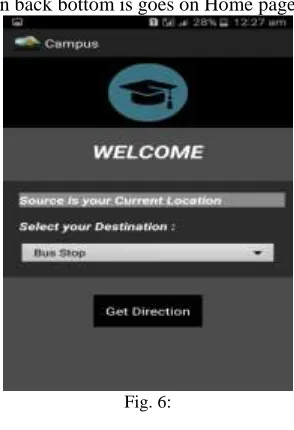
Home Page
This is the home page where user will select their destination and click on the Get Direction button.
Fig. 2: Select Destination Point
You are entering in home page there is one drop box is their user can select their destination point. It is type of array it have many option such as Trinity college, Boys Hostel, Bus Stop, Canteen, Office, Library etc.
Fig. 3: Map
If user select Trinity college, then map navigate the direction and show proper path .it look like below image If user can select canteen and it will show canteen path.
user can select any destination point inside the campus and navigate and show proper path.
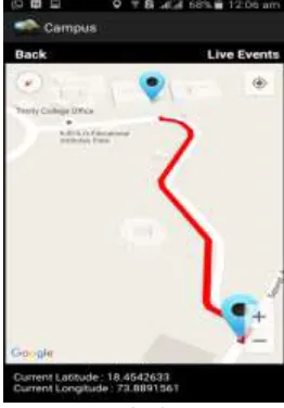
Fig. 5: Live Events
In these app right top there is one live event button which can show live event which are access from data base when user click on live event button they can show event list to user and if user select then it show event path.
Back Button
In these there is back button when user click on back bottom is goes on Home page.
Fig. 6: III. RELATED WORK
Identity-based access control was initially proposed by Shamir, who also introduced the first identity-based signature scheme. In multiple encryption, a cipher-text is proposed by combining the overall results of various instances of an encryption algorithm with different encryption key. In this digital contents likes audio, video, images are encrypt using a combination of a user public key and its identity.
IV. LITERATURE SURVEY
traditional paper map image of a locality with a satellite map image. A user provides a custom map of particular location and the corresponding satellite map is retrieved from Google Map. The geo image mapping engine is responsible for related and align the two maps; the result is passed to the map rendering engine which then displays the overlaid map to the screen. Every known point of interest marked clearly. algorithms, auditing techniques and digital signature for data integrity. Sahai and Waters [3] proposed the ABE system and it is the first scheme which achieve the One-to-many public-key encryption. In this scheme, the cipher text and the user secret key are related with the set of attribute and these set of attributes act as a access policy. Only when there is a match between the attribute of the decryption key and cipher text, the users will be capable of decrypting the cipher text. It not only uses a GPS but also an onboard compass as well as an accelerometer for higher accuracy of current location of user. The application accessible in offline mode mean without internet connection. The live view mode requires an on board rear camera typically found in most today’s mobile devices. Mihaela Cardei, Iana Zankina, and Daniel Raviv, Department of Computer and Computer Science Florida Atlantic University, Boca Raton campus designed a system of campus assistant application. The application provides facility to choose starting and destination location and it gives shortest driving and walk able path and it also provides suitable parking lots for the user. It also shows user’s current location with the help of GPS. The application provides rerouting when the user discontinues from the projected path. They have designed a Map Editor tool to edit and manage campus maps. These maps are stored on the server as XML files. The Map Editor tool uses HTML 5, JavaScript, and jQuery. They have used Google Maps API V3 for displaying maps and plotting markers. The Map Editor tool provides facility to faster manipulation of map and its XML file. Building, streets, parking lots are not available in Google Maps, this can be included, deleted, updated in the map with the help of Map Editor Tool. From the android mobile, user accesses the most recent version of map. It uses JSON/HTTP protocol to request an XML map file from the Mapping Server. Mihaela Cardei, Brandon Jones and Daniel Raviv, Florida Atlantic University added contextual information for mobile user navigation applications. It adds contextual information in the path of destination from user’s current location. They use Dijkstra’s algorithm to calculate shortest path. Sagnik Bhattacharya and M. B. Panbu designed and developed an application named Mobile Campus on android based mobile platform for KJ University campus. University campus tour guide application will work on NFC enabled smart phones on Android platform. It can be used by visitors/ students/ parents. This application includes basic functionality such as showing map of K J campus, showing route from source to different location can locate user current location. User can also view important landmarks and information about upcoming event like seminar, sports etc. NFC enabled devices connect automatically with other NFC devices when other smart phones come into close range and provides current event information. Hsien Tang Lin provides a Comprehensive Guid and Navigation Services on Smart Phone for 2013 Taiwan Lantern Festival. This application provides guidance and navigation service with a custom map, not simple Google map. It converts public map onto custom map in graphic format. The custom map may be in Kmz format. A kmz is a zipped file contains KML files which specify a set of features for display in Maps. This kmz files loaded onto the application to show navigation on custom maps. When the visitor is interested in the POI (Point of Interest), then he/she may activate the guiding service. Anupriya and Mansi Saxena implemented a map navigation system for travelling salesman problem on android using Google map and Google Geo-Coder API [7]. A campus spatial information service system [8] was developed by author using Google map. The System is mainly the combination of Google Maps and MySQL database. The system provides such facility of interactive information such as the picture, description, link and the useful measurement tool. The system also provides zoom out, zoom in, pan, eagle eye and the browser of the spatial 11. information, inter query between figure and text, complex path measurement etc. User can add his POI and Information about POI to database and it provides option of taking feedback from user. 2.0 technologies: DHTML, CSS, Ajax Population web programming language: PHP Web server: Apache Open source database: MySQL Map presentation platform: Google Maps API A useful model for the future digital campus [10] of Wuhan University of Technology was made by the author. This is a kind of GIS based campus navigation system. GIS (Geographic Information System) is a technology that integrates computer graphics and databases, which stores and processes spatial information. The system is mainly developed for school teachers and students, integrated schools teaching resources, infrastructure, service place and other data information, using GIS technology to provide teachers and students for digital and intelligent information services. This system includes several modules like Education management, Query management, Campus navigation etc. Based on Map Objects and Visual Basic, authors developed this system. A location based nearest ATM search is developed by Gugapriya A, Vaitheki J and Kaviyarasi S [9]. It’s a pure application of GPS based location tracking service. The application combines banking service with location based service. Shaveta Bhatia and Saba Hilal compare various approach of location tracking and also proposed and implement a new algorithm [6] on Android 4.0.
V. PROPOSED WORK
Global Positioning System (GPS)
Android SDK
The Android Software Development Kit contains all of the lower level tools to build, run and test your Android application. It was released by Open Handset Alliance in the month of November of the year 2007. Android is actually developed using the kernel of Linux 2.6 [11]. The main features of SDK are no fees for licensing, distribution and release approval, GSM, EDGE, and 3G networks for telephony or data transfer, allowing us to make or receive calls or SMS messages or to send and retrieve data across mobile networks, API’s for location based services such as GPS, accelerometer and compass hardware, an integrated open source Web based browser, mobile optimized hardware accelerated graphics including a path based 2D graphics library support for 3D graphics using OpenGL .
Android Developer Tools (ADT)
The Android Developer Tools plugin for a Eclipse provides a professional grade development environment for building Android application. As mentioned earlier, the ADT plugin conveniently incorporates most of these tools into the Eclipse IDE. The Android SDK includes several tools and utilities to help us create, test, and debug our projects. It can emulate any device using custom screen sizes, keyboards, and other hardware components. The Dalvik Debug Monitoring Service (DDMS) is a powerful debugging tool that lets us interrogate act processes, view the stack and heap, watch and pause active threads, of an explore the file system of any active emulator.
VI. PERFORMANCE ANALYSIS
Though Google map is very helpful to find a location and alternative route to the desired location from user own location. But it is not so much helpful for our university campus because there are many departments, schools, library, canteen, playground, gates, hostel, jhils, and parking lots etc. which are not properly shown on Google map. University campus is growing faster and as a result changes are happening inside campus.
Dependability on Android Application is growing faster with the advancement of smart phone technology. There are lots of Google map based apps on market. There are some technologies to display custom map. This can be achieved through Storing location data on XML file and place this XML on a server Displaying map taking location information data from MySQL server Spread event information with the help of NFC technology. The aim of this research work is to develop a user friendly, Google map based application for university campus navigation and updates of event information on android mobile in some different way. This application will show user’s current location in the campus or outside campus with a marker. This will provide a categorized menu of places of both Jadavpur University campuses. Users can get the desired places with a marker and also shortest path from current location. Users can also get updates about event information. Users can view any new building, canteen, playground, etc.
VII. SYSTEM ARCHITECTURE
System Architecture
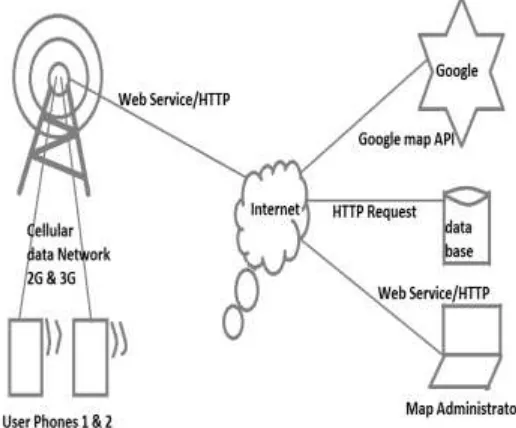
The architecture of the entire system is shown in figure 1. At first the application in the user’s phone, requests for Google API from Google server.
VIII. DATA-FLOW MODEL
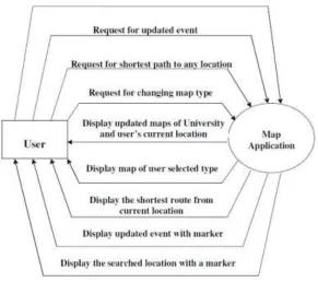
The fig 2 shows the Level0 DFD of the application. All the user’s request and response from application are designed. When user opens the application, it will show campus map of Jadavpur University with a customized version of Google Maps and it also shows the users current location with a distinct marker.6. Now user can download, upload, delete data with his/her private key. If user requests for changing map type, choosing from menu options, the application will display map of user’s desired type. If user requests for shortest path to any location from user’s current location, then the application will display the shortest path with colored line. When user requests for event updates from menu options the application will display the updated event information with a distinct marker with its User Map.
Fig. 8: Advantages
1) It’s using smartphone and different network. 2) It can be used to implement for University Campus. 3) It can be use in IT park.
4) It can be use in Large society Project. 5) It can be used for Business purpose.
IX. FUTURE WORK
In future any one can easily find any location inside the University like entrance gate, department, canteen, library, playground and parking lots etc. for the newly admitted student and visitor. This application provides shortest route guide for user from His/her own location desire location event update with its proper place. In the near future the Internet and wireless technologies will connect different sources of information such as sensors, mobile phones and cars in a tighter manner. The number of devices which connect to the Internet is –seemingly exponentially –increasing. These billions of components produce, consume and process information in different environments such as logistic applications, factories, airports and in the work and everyday lives of people. The society need new and scalable, compatible and secure solutions for both the management of the ever broader, complexly-networked Internet of Things, and also for the support of various business models.
ACKNOWLEDGMENTS
X. CONCLUSION
In recent years with the help Google maps, location searching becomes a new trend when people are not functionalities like showing any location, alternatives path from any location to other location and estimates time to reach the location. But it is not well developed or so much helpful for university campuses.
REFERENCES
[1] Mihaela Cardei, Iana Zankina, Ionut Cardei, and Daniel Raviv, “Campus Assistant Application on an Android Platform,” IEEE, 2013.
[2] Piyanuch Silapachote, Ananta Srisuphab, Rasita Satianrapapong, Warat Kaewpijit, and Nuttaporn Waragulsiriwan, “A ContextAware System for Navigation and Information Dissemination on Android Devices,” IEEE, 2013.
[3] Mihaela Cardei, Brandon Jones and Daniel Raviv, “A Pattern for Context Aware Navigation,” 20th Conference on Pattern Languages of Programs (PLoP). PLoP’13, October 2326, Allerton Park, Monticello, Illinois USA, 2013.
[4] Sagnik Bhattacharya and M. B. Panbu, “Design and Development of Mobile Campus, an Android based Mobile Application for University Campus Tour Guide,” International Journal of Innovative Technology and Exploring Engineering (IJITEE) ISSN: 22783075, Volume2, Issue3, February 2013. [5] Hsien Tang Lin, “The Comprehensive Guiding and Navigation Services on Smart Phones,” IEEE, 2013.
[6] Shaveta Bhatia and Saba Hilal, “A New Approach for Location based Tracking,” International Journal of Computer Science Issues (IJCSI), Vol. 10, Issue 3, No 1, May 2013.
[7] Anupriya and Mansi Saxena, “An Android Application for Google Map Navigation System Implementing Travelling Salesman Problem,” International Journal of Computer & Organization Trends ISSN: 22492593, Volume3, Issue4, 2013.