Available Online at www.ijpret.com
901
INTERNATIONAL JOURNAL OF PURE AND
APPLIED RESEARCH IN ENGINEERING AND
TECHNOLOGY
A PATH FOR HORIZING YOUR INNOVATIVE WORK
BLUE-FI BASED NAVIGATION SYSTEM
PALLAVI HOLEY1, PROF. VISHWAS T. GAIKWAD2
1. M.E. Student (Computer Science & Engg), Sipna College of Engg & Technology, Amravati, Maharashtra.
2. HOD, Department of Information & Technology, Sipna College of Engg & Technology, Amravati, Maharashtra.
Accepted Date: 27/02/2014 ; Published Date: 01/05/2014
\
Abstract:The major challenge in front of visualy impaired person is a way finding- the ability of a person to find out his own route. Generally it is seen that those impaired persons need to depend on other persons. In the outdoor environment they do their work with the help of GPS Most Visually impaired persons tend to do their productive work in the indoor spaces like offices, schools etc. and do not wish to be socially awkward. The GPS is only work in open atmosphere but those signals cannot able to useful at the indoors. Wi-Fi infrastructure which works outdoor as well as indoor area. There is no any requirement for special arrangements of special network like RFID and mesh network in the Wifi infrastructure. Here we prepare a review paper for a mobile-phone based indoor navigation system which is easy to use, low-cost.
Keywords: Bluetooth, Wifi, Wifi access points, speech synthesis etc.
Corresponding Author: MS. PALLAVI HOLEY
Access Online On:
www.ijpret.com
How to Cite This Article:
Pallavi Holey, IJPRET, 2014; Volume 2 (9): 901-908
Available Online at www.ijpret.com
902 INTRODUCTION
The number of people with visual disabilities is around 135 million, of which 45 million are blind[5].For people with visual disabilities navigation in unfamiliar buildings is more difficult than outdoors. Visually impaired persons have a lot of problems to acquire environmental information. Moreover, obstacles which are not dangerous to ordinary people are able to become dangerous to them. Most of time they need to be depend on other persons for their work. Though they use blind stick to acquire these information, it is still hard for them to walk around in most of the places and also not cover whole area. A lot of studies have been done to develop a system which assists blind people. The main difficulties in the indoor navigation are : missing known landmarks, overcoming obstacles it might be risky sometimes, not all the blind can read Braille tags. One of the major disadvantages of the existing indoor navigation systems for the blind is the high price of hardware part, which in most cases is not consistent with the income of blind people.
The work we present in this paper is based on the review of some latest papers which are based on bluetooth and wifi to improve visually impaired people mobility. Here we explain the low cost infrastructure and easily available wifi and the bluetooth in mobile phone.
1. MATERIALS AND METHODS
1) Bluetooth :
Bluetooth is the first wireless technology. Bluetooth is useful for short-distance device-to-device communication. The most basic form of Bluetooth connectivity exists in the form of the master and slave. A master Bluetooth device is connected and communicates with a number of slave devices in the network. The bluetooth is generally use for connecting the devices for exchanging the data between them.
Bluetooth access points:
Available Online at www.ijpret.com
903 related to work zone and signalized intersection by comparing the ID of detected Bluetooth beacons with the spatial database. And then tell the direction via speech synthesis.
How to measure distance by bluetooth access points:
• y = dependent variable
• α = regression coefficient
• x = input variables
• β = error term
y = αlnx + β
Fig1: Bluetooth System
2) Wi-Fi :
Wi-Fi is another technology we considered to locate the user. Using Wi-Fi access points, we would the user’s location based on signal strength. Wi-Fi works by mapping received signal strength indicator into a distance. The system uses both Wi-Fi and Bluetooth requiring the user must connect to both networks when entering a building to determine their location.
Available Online at www.ijpret.com
904
Fig2 : Relation Between WiFi and Bluetooth Access Points
3)Server:
Server plays a very important role in the system. It stores the information of many assets. for example it stores the bluetooth addresses and device names in it, Which is used for the further process.
At the time of localization finding the database on the server being used.
4)Wi-Fi access points:
Wi-Fi access points are used for connecting devices. It connects the devices like the LAN.
How to measure distance by Wi-fi access points:
• f = is the signal frequency (in hertz)
• d = is the distance from the transmitter (in meters)
• c = is the speed of light in a vacuum.
FSPL is the function of frequency and distance between transmitter and receiver.
FS PL(dB) = 10log10(( )
5)Node of Gateway:
The Gateway nodes are those nodes which are being used to connect the bluetooth & the WiFi network.
III. SYSTEM IMPLEMENTATION
Blue-hi based system work as follows:
This system take the input from the gateway node and server which stores the distance information of different palaces from the user. This system is used for accurately find out the distance of the user.
Available Online at www.ijpret.com
905 • xn : X-Coordinate of the receiver n(in meters)
• yn : Y-Coordinate of the transmitter n(in meters)
• dn : distance calculated by the corresponding model of the transmitter n(in meters)
• x : unknown X-Coordinate of the receiver
• y : unknown Y-Coordinate of the receiver
= ( − ) + ( − )
With the help of this equation it find out the exact location of user and other place.
• ˜x : vector of unknowns corresponding to the X-coordinate and Y-Coordinate of the receiver.
• A, b : System of equations in matrix form
x = ( )
Given this, x and y values, corresponding to the coordinates of the receiver, are estimated with the minimum amount of error.
After collecting and calculating the distance of user and the place through the Wi-fi and bluetooth gate way node it stores all the information at the server then according to the changing location the following process dectects the route to user.
The speech recognition, speech synthesis and command processing takes place as follows:
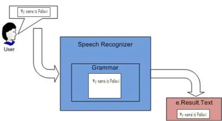
Speech recognition:
Fig 4:speech recognition
Available Online at www.ijpret.com
906 Speech synthesis:
In the speech synthesis the text format is converted into the voice for the next step in which that voice is detected to the user in form of commands.
Fig5:Speech synthesis
Command processing:
In the command processing after understand the knowledge it can do the correct task, what the user need Then the interaction processes. simultaneously speak with user for effective communication and verify the task.
Fig6:command processing
IV. RESULTS AND DISCUSSIONS:
Available Online at www.ijpret.com
907 any heavy circuit or anything with the user. only with the help of mobile phone he can able to track his own way.
V.CONCLUSION
In this paper with the help of WiFi and bluetooth which are the low cost and easily available. wifi is the easily available infrastucture in the present decades. here we used the mobile phones for tracking and speech synthesis. which are easily available to any person. there is large scope after adding some recent features in this system. for example barcode scanner and generating the map. The most important thing related to this paper is it have the very low cost as compare to the other infrastructure like RFID, mesh network.
VI.REFERENCES
1. How Bluetooth Surveillance Works, How Stuffs Work.
2. Chung-Hsin Liu, Jian-Yun Lo, “The study for the ZigBee with Bluetooth Positioning System”, in Proceedings of International Symposium on Computer Communication Control and Automation (3CA), 2010.
3. S. Aparicio, J. Pérez, A. M. Bernardos, J. R. Casar, “A Fusion Method Based on Bluetooth and
4. WLAN Technologies for Indoor Location”, in Proceedings of IEEE International Conference on Multisensor Fusion and Integration for Intelligent Systems, MFI’08.
5. Beom-Ju Shin, Kwang-Won Lee, Sun-Ho Choi, Joo-Yeon Kim,Woo Jin Lee, Hyung Seok Kim, “Indoor WiFi Positioning System for Android- based Smartphone”, in Proceedings of International Conference on Information and Communication Technology Convergence ICTC’10.
6. Wilson M. Yeung, Joseph K. Ng, “Wireless LAN Positioning based on Received Signal Strength from Mobile device and Access Points”, in Proceedings of 13th IEEE International Conference on Embedded and Real-Time Computing Systems and Application, RTCSA’07.
7. Omar Cruz , Erik Ramos †, and Moisés Ramírez, “3D Indoor Loca on and Navigation System Based on Bluetooth”, in Proceedings of 21st International Conference on Electrical Communications and Computers (CONIELECOMP) 2011.
Available Online at www.ijpret.com
908 9. Cypriani, M. Lassabe, F. Canalda, P. Spies F, “Wi-Fi-Based Indoor Positioning: Basic Techniques, Hybrid Algorithms and Open Software Platform” , in Proceedings of 2010 International Conference on Indoor Positioning and Indoor Navigation (IPIN).
10.Chung-Hsin Liu, Jian-Yun Lo, “The study for the ZigBee with Bluetooth Positioning System”, in Proceedings of International Symposium on Computer Communication Control and Automation (3CA), 2010.