Development and Implementation of Web-Based
Advanced Traveller Information System
A. Abdulkareem, C. O. A. Awosope, O. O. Opeyemi, and K. Okokpujie
ABSTRACT—The advancement of technology has brought about a proliferation of various modes of transportation such as land, aerial and maritime. The increase in the choice of transport modes has however not led to greater efficiency in the travel patterns and trip times of citizens. Traffic congestion has become a norm in cities with dense populations, with citizens enduring hours spent in traffic conditions. In a bid to increase efficiency of overall road transportation, a concept known as Intelligent Transportation Systems (ITS) has been propounded. This work is based on the development of an Advanced Traveller Information System (ATIS), which is one of the four systems detailed in the ITS specification. This paper showcases the development of an ATIS using modern web technologies, which can be used by citizens to obtain useful travel information such as directions, routes and public transport shuttle locations and arrival times. The system is implemented using the Python and JavaScript programming languages, and MySQL for database services. It was tested at Covenant University and found to be faster, capable of reducing travellers’ cost and destination time.
Index Terms—JavaScript, MySQL database, python programming, traveller information, web technology
1. INTRODUCTION
It has been forecasted that traffic congestion is on the rise, and there exists a growing interest in the road demand management and road pricing solutions [1]. These occurrences have increased the awareness of the need for research and implementation of Advanced Traveller Information Systems. These systems provide assistance to travellers and commuters alike, helping them to select routes, transportation modes (such as buses, cars, bicycles and so on), how to minimise journey costs, possible delays before they set out, and as well as during their journeys. ATIS have been a topic of research for the past 2-3 decades worldwide. Up until the 21st century, major research had not been undertaken in Africa, with most of the valuable research being done in the U.S.A, all the major European countries and Indian [[2], [3], [4], [5].
Manuscript received June 23, 2018; revised July 25, 2019.
A. Abdulkareem is a Senior Lecturer with the Electrical and Information Engineering Department, Covenant University, Ota, Nigeria (phone: +234 08033009714, e-mail: [email protected]) C. O. A. Awosope is a Professor with the Electrical and Information Engineering Department, Covenant University, Ota, Nigeria.
O. O. Opeyemi is an Electrical Engineer with Electrical and Information Engineering Department, Covenant University, Ota, Nigeria
K. Okokpujie is a Lecturer II with Electrical and Information
However, some developed countries such as the Germany, United Kingdom, Sweden and The United States of America [6] have recognized this need and as a result have deployed Intelligent Transportation Systems, with Advanced Traveller
information about their journeys, and as a result consistently get trapped in massive traffic jams and spend hours on the road. This, in turn, has a negative effect on the environment as more Carbon Monoxide (CO) gases released into the atmosphere, increasing the amount of carbon in the atmosphere. This leads directly to short-term increase in temperatures and contributes to long-term global environmental issues such as global warming and climate change [7].
Increasing the efficiency of citizens’ travel patterns has compounding benefits. As more people begin to plan their trips more efficiently, the need to use a personal vehicle for transportation is alleviated. Thus, reducing the number of vehicles plying the roads leads to less traffic congestion, and reduces the amount of carbon being released into the atmosphere. Although, there are systems which have been built to serve as traveller information systems, they have not been well focused for the peculiarities of the African/Nigerian market. Such systems fail to take into account the inefficiency in the public transport systems in the region and may not even provide information for the region entirely. This work is focused on creating a working prototype of an ATIS which can be readily deployed anywhere in the country. It is aimed at showcasing the different features available in the system and how these are capable of adding value to the end user.
II. MATERIALS AND METHODS
The Web application is developed using the Python and JavaScript programming languages, with the use of two Integrated Development Environments (IDEs); PyCharm 2017.8 for Python development and Web Storm 2017.6 for JavaScript development. The database utilized is MySQL, with the Google Chrome Browser Database Management System Plugin used for database management.
A. System Architecture
JSON (JavaScript Object Notation) standard format. These includes the following: API (Application Programming Interface)/ Server-Side Service, MySQL Database Server and Client-side Service.
Fig. 1. System Architecture
B. Features of the Application
The core features of the application are constructed using three core sections of application logic. These features constitute the API and the application logic which include: user features, shuttle features and location features. The core features contained in each of the section are selected and de-mystified accordingly. The sign-up data entry flowchart for the system is shown in Fig. 2.
User Features
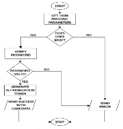
These features are those which directly concern the services provided to users directly. Users include admins, regular users and drivers. The most important endpoints concerning user features are: User Registration Endpoint, User Login Endpoint and Fetch Users Endpoint. The major scenarios to ensure that users make optimum use of the services available are:
Users should be able to register successfully; Each registration email must be unique;
Users’ details should be possible to retrieve from the database;
Users should be able to login successfully, on providing accurate credentials; and
Details of all users should be possible to be retrieved from the database, for administration purposes
Fig. 2. User Login flowchart
Shuttle Features
These features are those which directly concern the services directly affecting the utilization of shuttles and their associated information. Each shuttle created must have an associated user, which would be designated as a driver. The most important endpoints concerning shuttle features are to create shuttle endpoint and fetch shuttles endpoint as presented in Fig. 3. The major scenarios to ensure that users make optimum use of the services available are:
Users should be able to create shuttles successfully; Only drivers should be able to create shuttles;
Details of all shuttles should be possible to be retrieved from the database, for administration purposes; and Location information should be provided when a driver
switches a shuttle’s mode to ‘en-route’ .
Fig. 3. Get all shuttles flowchart
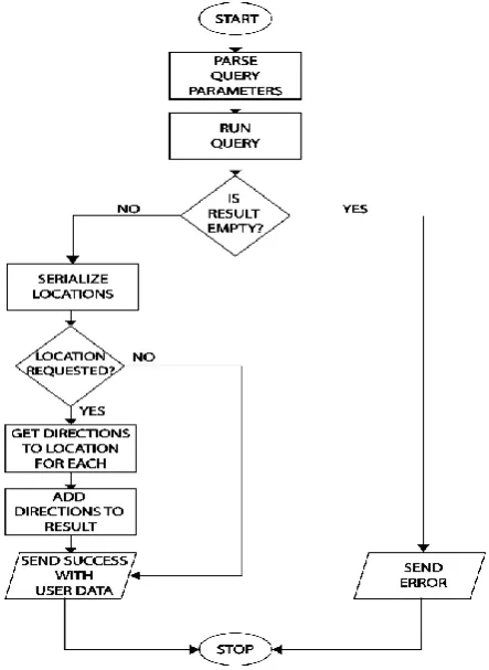
Location Features
These features are those which directly concern the services that involve the use of locations and their associated information. The two types of locations are bus stops and buildings. The most important endpoints concerning location features are add location endpoint, fetch locations endpoint and user geolocation using the Web Browser. Fig. 4 presents the flowchart for all locations. The major scenarios to ensure that users make optimum use of the services available are:
Users should be able to create locations successfully; Only admins should be able to create and modify
locations; and
[image:2.595.306.543.163.510.2] [image:2.595.49.247.546.754.2]Fig. 4. Get all locations flowchart
III. RESULTS AND ANALYSIS
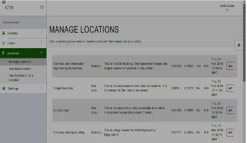
This section shows screenshots of the deployed application, with the concerned scenarios tested adequately represented. The application was developed with three sections of application logic, as discussed in the preceding section. The section includes the interface where the details and personal information of the user are imputed and sent to store in the database.
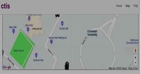
The shuttle and location features that display the available shuttle information as well as individual shuttle information are as shown in Fig. 5 and Fig. 6 respectively. Such information includes the number of available shuttle, current location, departure location and time the next shuttle arrives. Fig. 7 presents the Admin screen to manage the available shuttle information, while the manage admin screen is as presented in Fig. 8.
Real-Time Implementation
The real-time functionality of the system enables shuttle markers on the map to be changed in real-time, providing the user with real-time geographical information about the driver. This service is provided using PubNub, which provides real-time Infrastructure for different platforms such as mobile, web and Internet of Things (IOT) devices. The following images, Fig. 9 (a-c) show few of the results of the
test conducted within covenant university campus on the real-time implementation.
IV. CONCLUSION
The concept of Advanced Traveller Information Systems has the potential to solve transportation problems plaguing citizens in the local, state and national regions. Proper design and development of such systems as a part of Intelligent Transport Systems would improve the mobility, safety and efficiency of transportation in the country. The technology has positive influence on the environment, as a result of the reduction in traffic congestion; leading to the reduction in the amount of time spent on roads by cars; leading to the decrease in the amount of Carbon released into the atmosphere, which reduces the risks of global warming, sporadic temperature increases and climate change.
ACKNOWLEDGMENT
The author is highly indebted to the management of Covenant University, Ota, Nigeria, for the conference support fund.
REFERENCE
[1] S. a. a. S. V. Pal, "GIS Based Transit Information System for Metropolitan Cities in India," in Geospatial World Forum, Hyderabad, India, 2011.
[2] Wikipedia “PIV VISSIM – Wikipedia” ed: PTV Platung Transport, 2017.
[3] V. S. Praveen Kumar, “Advanced Traveller Information System for Developing Countries,” in 23rd ARRB Conference, Adelaide, Australia, 2008.
[4] P. Zito, G. Amato, S. Amoroso, and M. Berrittella, "The effect of Advanced Traveller Information Systems on Public Transport Demand and its Uncertaity,” Transportmetrica, vol. 7, pp. 31-43, 2011/01/01 2011.
[5] D. C. S. Chun-Hsin Wul, Justin ChangI, Chia-Chen Weil, Jan-Ming Hol, “An Advanced Traveller Information System with Emerging Network Technologies,” pp. 8, 2005.
[6] A. Abdulkareem,C.O.A. Awosope, A. E. Tope-Ojo, “Development and implementation of a miniature RFID system in a shopping mall environment”
,
International Journal of Electrical and Computer Engineering, vol. 9, no. 2, , pp. 1375,2019.[7] K. O., Okokpujie, E., Noma-Osaghae, M. Odusami, S. N. John and O., Oluga, “A Smart Air Pollution Monitoring System”, International Journal of Civil Engineering and Technology (IJCIET), 9(9), pp.799-809, 2018.
Modification Date: 25 July 2019
[image:3.595.55.277.55.359.2]Fig. 5. Screen displaying available shuttle information
Fig 9a. Real-time Tracking Test Screenshot 1
Fig 9b. Real-time Tracking Test Screenshot 2
[image:6.595.49.449.322.518.2] [image:6.595.48.455.559.760.2]