IT Issues for the Management of High Quantity, Low Cost Assets
William Rasdorf, Ph.D., P.E., F.ASCE, Professor
Department of Civil, Construction, and Environmental Engineering North Carolina State University
Raleigh, NC 27695-7908
Telephone 919-515-7637, Fax 919-515-7908 Email [email protected]
Joseph E. Hummer, Ph.D., P.E., M.ASCE, Professor
Department of Civil, Construction, and Environmental Engineering North Carolina State University
Raleigh, NC 27695-7908
Telephone 919-515-7733, Fax 919-515-7908 Email [email protected]
Elizabeth A. Harris, S.M.ASCE Ph.D. Candidate
Dept. of Civil, Construction, and Environmental Engineering North Carolina State University
Raleigh, NC 27695-7908
Telephone 919-515-6456, Fax 919-515-7908 Email [email protected]
William E. Sitzabee, Ph.D., P.E. Lieutenant Colonel, United States Air Force
Dept. of Civil, Construction, and Environmental Engineering North Carolina State University
Raleigh, NC 27695-7908
Telephone 919-326-0701, Fax 919-515-7908 Email [email protected]
Word Count: 7590 Words + 4 Figures
ABSTRACT
Transportation infrastructure asset management efforts have historically focused on collecting data on assets with high capital costs, such as bridges and pavements. Road signs and pavement markings, on the other hand, are high quantity, low capital cost assets but are also critical elements of the transportation infrastructure. These high quantity assets serve a critical function, safety, and thus they are receiving attention. Mandated by law, the Federal Highway Administration (FHWA) has been working to establish minimum retroreflectivity standards for signs and pavement markings.
This paper seeks to address the information technology (IT) problems that emerge when developing an overall asset management system for high quantity, low cost assets. These IT problems include asset identification, asset location, data availability, data fragmentation, and automated data collection. A discussion of the issues related to these problems is presented herein to promote awareness of the myriad problems that do exist and to facilitate the development of more comprehensive systems to manage the automation of infrastructure asset management systems.
OUTLINE
ABSTRACT
INTRODUCTION
- IT Elements in Asset Management o Core Databases
o Asset Management Capability Maturity
- IT Implementation Problems
ASSET IDENTIFICATION
ASSET LOCATION
DATA AVAILIBILITY - Missing Data - Lack of Data
DATA FRAGMENTATION
- Decentralized Control of Asset Data - Inconsistent Data Formats
DATA COLLECTION AUTOMATION CHALLENGES - Asset Condition Assessment
- Instrumentation Issues
FIELD DATA COLLECTION PROBLEMS
SUMMARY AND CONCLUSIONS
DISCLAIMER
IT Issues for the Management of High Quantity, Low Cost Assets
William Rasdorf, Ph.D., P.E., F.ASCE; Joseph E. Hummer, Ph.D., P.E., M.ASCE; Elizabeth A. Harris, S.M.ASCE; Major William E. Sitzabee, P.E.
INTRODUCTION
Maintaining aging transportation infrastructure concurrently with transportation budget constraints has resulted in a need for new tools to manage transportation assets. These tools include inventory, condition, and performance databases and models for predicting budget needs, maintenance, and asset performance among others. All of these databases and tools rely heavily on automated sensors and information technology (IT) to streamline the gathering, analysis, and interchange of transportation asset data.
The first major applications of IT to asset management focused on high capital cost assets (Markow, 2007). Some were low quantity, high capital cost assets such as construction equipment, bridges, and traffic signals (for state jurisdictions). These assets have a high unit capital cost, but only exist in limited locations within a transportation agency’s jurisdiction. The other major high cost asset, pavements, exists throughout the transportation system, resulting in pavements being both a high quantity and a high cost asset. Of course, IT has been applied to numerous applications. Adams, for example, addressed enterprise-wide data integration for oversize or overweight truck permitting (Adams et al. 2002). In doing so they identified a number of problems associated with data resources to support their application need.
Once management systems were developed using IT for high capital cost assets, the focus began to shift towards low capital cost, high quantity assets that had previously not been considered. Examples of high quantity, low cost assets include guardrails, roadway lighting, pavement markings, and signs, as shown in Figure 1 (clockwise from upper left). In NC, there are over one million road signs (Kirtley and Rasdorf, 2001) with an average replacement cost of $65 each and 78,000 miles of road with pavement markings whose average replacement cost is 35¢ per foot (Sitzabee, 2006).
IT Elements in Asset Management
Information technology is critical to asset management because IT enables raw and formatted asset data to be processed, stored, and utilized in an asset management system. For high quantity, low cost assets, the most common IT capabilities focus on (Markow, 2007):
• Inventory (quantity and location) • Current asset condition and age • Photographic documentation • Inspection and maintenance data • Tracking of public comments
Figure 1. Guardrail, Lighting, Pavement Marking, and Sign Assets (clockwise from top left)
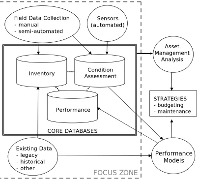
Figure 2 proposes how IT interactions could function in an advanced management system for a high quantity, low cost asset or group of assets. In this model, the major data sources are field data collection, automated sensors, and existing data. The existing data is comprised of legacy, historical, and other data. The term “legacy data” is only used to refer to data stored in legacy formats while “historical data” refers to any asset data collected prior to the implementation of the current asset management system.
condition assessment capabilities alone, while more advanced or mature systems include performance modeling and asset management decision analysis tools.
The proposed IT interactions model shown in Figure 2 can be categorized as an advanced asset management system because a performance modeling capability is included. Data from recent condition assessments as well as asset attributes from historical data are analyzed by the performance model, which populates the performance database with predicted service life for each asset served by the system. All three of the core databases are relational databases, allowing for complex queries to be generated and input to the asset management component of the system.
Figure 2. IT Interactions Model in an Advanced High Quantity, Low Cost Asset Management System
The asset management analysis component of Figure 2 evaluates the benefit-cost trade-offs between different management methods and, along with the performance model, generates a set of financial and maintenance management strategies for the asset(s). Reliable data and effective decision-support tools can reduce the costs for asset maintenance, repair, and renewal and lead to
Sensors (automated) Field Data Collection
- manual
- semi-automated
Existing Data - legacy - historical - other
Asset Management
Analysis
Performance Models
STRATEGIES - budgeting - maintenance
FOCUS ZONE
Condition Assessment Inventory
Performance
timely service with fewer disruptions (Vanier, 2001). This paper will focus on IT interactions within the “focus zone” shown in Figure 2.
Core Databases
The quality and breadth of the data within the core databases (contained within the solid double line of Figure 2) is largely determined by the data sources used to populate the databases. Manual and semi-automated (collected using some automated data collection techniques) field data collection typically contributes to the inventory and condition assessment databases. The condition assessment database can also draw data from automated sensors that report condition information such as temperature, deflection, or stress. Existing data from historical asset management efforts can be used to populate the inventory database if these data are relevant to the desired system IT capabilities. Additionally, the organizational and procedural framework used to collect the existing data can be applied to current field data collection efforts (Markow, 2007).
The inventory database serves as the primary repository of all attribute and positional data for each individual asset. Attribute data consists of the key characteristics of the asset (e.g., age, size, material) and positional data provides information on the location of the asset in space (Rasdorf, 2003; Karimi et al. 2000). By having a separate record for each asset, the quantity of assets matching certain criteria can be easily determined by the system. Photo records of each asset as well as any related installation or replacement cost data can be included in the inventory.
Because each asset in the inventory is given a unique numerical or positional identifier, a relational database management system could be used to perform queries requesting information from any combination of the three core databases. For example, the Inventory database would contain information about asset installation dates and the Condition Assessment database would contain asset condition data. The relational database system could perform a query that would match asset installation dates and condition data using each asset’s unique identifier. Assuming that there is a relationship between asset age and asset condition, the results of this query could be passed to the Performance Models module where they would be analyzed to determine the asset age/condition relationship. The developed performance model could then be used to predict when each asset would reach the end of its service life, and the predicted service lives for each asset would be stored in the Performance core database.
In addition to the unique identifier, the condition assessment database can include current condition data, information on the specific instrument(s) used to collect the condition data, inspection and maintenance reports, and public comments about asset conditions. Using the data from the condition assessment database and any applicable existing historical data source, the performance model determines the remaining service life for each asset and records this information back into the performance database. IT capabilities for the system need to focus on the concept that the databases themselves are assets to be managed (WERD, 2003).
Asset Management Capability Maturity
or mature IT asset management capabilities for high quantity, low cost assets can include the following features typically found in pavement, equipment, and bridge management systems (Markow, 2007):
• Benefit-cost and life-cycle cost analysis
• Integrated platform for internal and possibly external access to information • Accurate asset data collected regularly according to a predetermined schedule • Mix of data collection technologies used to collect high-quality data cost-effectively • Customer perceptions of assets regularly updated though surveys or complaint tracking • Movement from asset-specific management systems to broad-based management systems
The proposed IT asset management model shown in Figure 2 represents a moderately mature system because it includes predicted asset service life and interconnected relational databases. Efforts to apply features of mature asset management systems to high quantity, low cost assets have been hindered by several IT implementation problems. The main focus of this paper is to articulate these issues though an examination of current high quantity, low cost asset management practices and recommend strategies to mitigate these issues.
IT Implementation Problems
For low capital cost assets, several IT problems arise related to collecting, managing, and analyzing asset data. These include:
• Asset identification • Asset location • Data availability • Data fragmentation
• Unsuccessful data collection automation
Asset identification requires (1) assigning a unique identifier to each low value asset and (2) having this number accessible both in an asset management database and in the field at the asset’s location. The location of the asset also needs to be included in the transportation infrastructure asset management system’s core databases. The location information can be recorded and included in the database using Global Positioning System (GPS) coordinates, a linear referencing system (LRS), or through other means. Spatial technologies are particularly appropriate for integrating highway asset databases with highway geographic and geometric data. In a typical roadway LRS, each roadway is given a unique route number and the distance along the route from a specific point of origin (usually a state or county boundary) is used to locate points along the route. The distance units are usually marked with signs placed along the route (mileposts) to determine the position of either linear features (such as a guardrail segment) or data collection points in the field (Flintsch et. al., 2004).
standards in the Manual on Uniform Traffic Control Devices (FHWA 2007) and is developing similar minimum standards for pavement markings (Schertz 2002).
The fragmentation of existing data often results from transportation agencies and their private contractors using different data collection standards over time with the net result being that data are stored in dissimilar formats. Automated data collection for low value assets generally involves mobile units that can collect identification, location, and attribute data for hundreds or thousands of assets in a single day. Problems in automated data collection arise in calibrating the mobile unit or other automated data collection equipment, integration of the instruments and hardware in the unit, and integrating the collected data into the asset management system. The following sections expand upon each of these problems and discuss their IT implications.
ASSET IDENTIFICATION
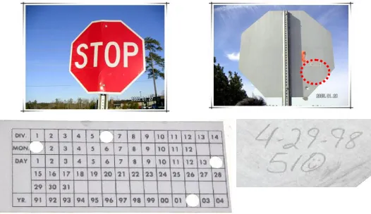
A key IT problem for low capital cost, high quantity assets is asset identification during data collection and analysis. Identification system technology is critical for IT implementations. In current practice, identification takes on several forms, often depending on whether the asset is a point or continuous (linear) asset.
Figure 3. Sample Current Traffic Sign Installation Date Labeling Methods
permanent marker to write an identification number on each road sign that was included in a study of sign replacement and deterioration (Rasdorf et. al. 2006). Such an identifier is shown in the lower right of Figure 3. The lower left illustrates the use of a preprinted label.
Continuous assets are those that are linear in nature and which are usually measured in length-based units. Guardrails, for example, may be assessed by foot whereas pavement markings may be assessed by mile. Other assets can be dual identified. Signs, for example, can be identified by a physical identification label as well as by spatial location identification.
Several asset identification issues surface from examination of current practice. The most important issue is that without an identifier, an asset cannot be linked to its attributes in a database. Most often, these assets in the field are not labeled, making it impossible to ensure that the asset is consistently identified over time. For point-specific high quantity data, labeling each asset in the field with an identifier can be a daunting task when millions of low cost assets need labeling. Physically labeling an asset using a sticker or marking can be problematic if the marking fades over time. Furthermore, these basic labels are not machine-readable, which limits complete data collection automation. This is the critical aspect of identification that most severely and negatively impacts the development of an asset management system. Some continuous assets, such as pavement markings, are very difficult to label at all due to their location and linear characteristics. Such assets cannot have an identifier, so they are instead identified by location as a linear feature. Linear features further complicate identification because not all linear features use a common distance unit or linear reference system.
Data identification issues can be addressed through a consistent point and linear asset labeling system and through technologies that facilitate inventory automation. To speed data collection, an asset’s identifier can be encoded into a barcode label placed so that field technicians can quickly read it using an electronic data collection device with a barcode reader. However, without a human-readable numeric identifier on the asset, agency staff without a barcode reader would be unable to identify it.
Technologies such as radio frequency identification (RFID) tags could also be used to obtain asset identifiers without the need to approach each asset. RFID is a wireless automatic identification technology that allows for contactless exchange of data between a passive RFID transponder tag and a reader (Dziadak et al. 2007). Signals from RFID tags can be read from a data collection vehicle traveling at or near highway speeds. RFID tags could facilitate an inventory but would not support condition assessment unless the RFID tag was modified to possess sensing features.
ASSET LOCATION
although imprecise, did help the team feel confident that they had identified the same sign (Rasdorf et. al. 2006).
The case of pavement markings in NC is illustrative. A look at the organization of NCDOT’s pavement markings data revealed a significant problem with the data collection. The NCDOT pavement marking retroreflectivity data were collected using a localized linear referencing system (LRS) invented by the data collection contractor. The contractor’s LRS did not conform to either the state or county milepost LRS system. Furthermore, the NCDOT’s contract with the data collection contractor did not prescribe that pavement marking retroreflectivity data be collected using a particular location referencing method. The system used by the contractor is a blended system that uses route identification with the start and end points identified with a milepost, intersection, or offset (Sitzabee, 2006). In some cases the pavement marking retroreflectivity data were recorded with a common name format to identify the start and end point of a data collection run. For example, location data were recorded as beginning at the “Jackson East city limit” and ending at the “Conway West city limit.” The common name had to be matched to the route information in order to locate the segment’s position. Through this manual, labor-intensive, and costly process that does not support automation and IT, the links could be established to locate each segment. Thus, because of the unique LRS used, the localized referencing system precludes the integration of pavement marking retroreflectivity data with the existing NCDOT database structure.
High quantity, low cost asset location issues are centered on nonexistent, inconsistent and/or imprecise asset location data. A lack of asset location information can arise both in existing data as well as during the data collection process. Existing data may have been collected without location information, or the location information is in a non-standard format that is difficult to incorporate into a database that can be read by a geographic information system (GIS). This problem is acute for low capital cost, high quantity assets because they are often not located at an intersection or other easily recognizable place on a map.
Even if an asset has a GIS-readable location, imprecise location measurement can hinder the ability to distinguish between nearby assets. Generally, as location precision increases, the cost of data collection increases as well. Currently, basic GPS devices can measure with a resolution of ± 30 ft. and more expensive GPS units with differential correction can achieve a resolution of ± 10 ft. Odometers used for determining LRS position have an accuracy of a hundredth of a mile (53 ft). A LRS can also develop errors due to the approximation of the three-dimensional Earth by two-dimensional representations such as maps and GIS (Cai et al. 2006, Rasdorf et al. 2003). This is due to elevation changes causing field-measured distances to be greater than their scaled distances on a map. Errors in GPS coordinates due to satellite geometry and environmental interference can make it difficult to distinguish between two adjacent assets and to determine which side of the road an asset is located on in a GIS application. All these issues can mean that the gigabytes of data collected over many years is worthless – a catastrophic, but altogether too frequent, occurrence.
collection contractors, but clear technical specifications on what data to collect, how to collect data, how to identify assets, and how to specify asset location with the goal of integrating the data with existing systems. These contracts are a critical part of IT and are essential for developing and maintaining a viable asset management system.
More specifically, for road signs, lighting, and other assets located at a single point, GPS is preferred to a Linear Referencing System (LRS) because GPS coordinates locate a single point in space and are easily imported into a GIS. However, an LRS can work with GIS if used properly and consistently. Integrating GPS data with data collected and stored using a LRS can sometimes be difficult and usually requires significant processing (Flintsch et al. 2004). Due to the precision differences between different location measurement methods, it is important that the devices and specifications used to collect the data are known, are documented, and are dated. If there are any changes in precision over time it is critical that the instrument precision be stored as well as the instrument measurements.
DATA AVAILABILITY
Asset data can be unavailable for several reasons. Data may never have been collected, may have been collected but lost, may be inaccessible, or may be missing. Some historical data may exist but may not be readily available. An agency might know that they once collected the data, but the physical location of the data is unknown. Data can also be inaccessible because the hardware and software that was used to create the data are in some form that is no longer usable (such as obsolete or older versions) or because an agency or company is hesitant to share proprietary data.
Missing Data
Some high quantity, low cost asset databases currently contain missing or partially filled data fields. In NC for example, there are no pavement marking retroreflectivity (condition) data available beyond five years ago and much of the data for the last five years has gaps and missing attributes not to mention the LRS problems identified above (Sitzabee 2006). In many cases the non-available data were recorded with a value of zero. This practice makes the assumption that the value is actually zero and not missing.
Missing fields for a particular asset make it difficult to fully analyze all assets in the asset management system. They can result in the need for additional data collection to obtain the missing information. If the asset is no longer in service, the data can be permanently lost, reducing the effectives of the asset management system. Statistical software counts a zero as a value, which skews the analysis. Unavailable data recorded as a zero requires an extensive effort to clean the database and replace all zeros with null values. The authors suggest that in all areas where data are unavailable, cells should contain a null value so statistical software can deal with the missing data appropriately.
Lack of Data
Presently in many U.S. transportation agencies, inventory and expenditure data on high quantity,
low cost assets are simply not kept at the individual item level (Markow, 2007). This is not an
problem for low capital cost, high quantity assets. The lack of available data has caused researchers and practitioners to use surrogate replacement measures such as utilizing sign or pavement marking retroreflectivity data from studies conducted in other states. Agencies can either initiate their own data collection program or use existing data already collected by others.
Since the problems related to initiating a data collection effort have already been discussed, this section will focus on the issues associated with using existing data. The key problem with using existing data, as mentioned earlier, is related to standardization. That is, the data that have been collected for one agency will not quite be the data desired by another agency. There will be something different about them that may render them useless for the desired application. However if that turns out not to be the case, the data can be effectively used. Another problem is that many agencies have no central repository for valuable data. That means that a great deal of data collected at the state level is not conveniently stored and thus, is not available for sharing and for general use. Inventories for high quantity, low cost assets are usually incomplete, are organized so others cannot use them, or are out of date.
The authors recommend that agencies identify desired data and determine if the desired data do not currently exist in the organization. Two options are then available: initiate a data collection effort or use the existing data from others. If no historical data is available, an agency needs to design a field data collection program. The program may require equipment (such as vehicles), instruments, hardware and software, labor, and funding.
DATA FRAGMENTATION
If asset data exist, they are often fragmented due to agencies using different and incompatible data collection standards over time and the data being stored in dissimilar formats. During a data collection program, the attributes collected over time can change, creating a database with columns missing depending on when the data were collected. An inconsistent column set can make it impossible to compare changes in asset attributes over time, thus reducing the utility of an asset management system.
Decentralized Control of Asset Data
Current attempts to create agency-wide asset databases have been hindered by different units of the same agency using different column sets and units. For example, in NC there are three organizational units that perform pavement marking inspections and data collection. They are the Work Zone Traffic Control Unit (WZTCU), the State Maintenance Unit, and the individual divisions (field offices). Serving different purposes, each player performs a different kind of inspection on pavement markings and collects a different set of pavement marking data.
The WZTCU is charged with setting standards and specification for pavement markings and they are the lead unit responsible for implementing the legislative standards that will eventually require minimum retroreflectivity levels for pavement markings. As such, the WZTCU collects pavement marking retroreflectivity data using both manual and an contracted automated mobile collection device.
appurtenances. The State Maintenance Unit conducts a manual assessment of a sample of roads. The MCAP is conducted biennially.
The current division level procedures for inspection of existing pavement markings is typically a windshield inspection that assesses the asset in terms of “present, visible, and reflective at night.” The most common recordkeeping methodology is a hardcopy map of the road system. For instance, Division 6 highlights each road using a color system to reflect when it was inspected and when it was remarked. As a result of the different data collection needs of these units, pavement markings data are fragmented in NC. If an agency determines that a centralized asset database would best serve asset management needs, collaboration between each organizational unit that manages that asset is necessary to determine how data should be collected, stored, and accessed.
Inconsistent Data Formats
As mentioned in the data availability section, agencies often use existing data to populate “new” high quantity, low cost asset management databases. In developing their new asset management system, the Tennessee DOT is incorporating digital data going back to the 1970s as well as archived paper forms (Haas and Hensing 2005). Sitzabee (2006) found that existing data on the number of times a pavement marking was snowplowed had multiple entries recorded in a single cell. For example, a cell for a road segment for one year will be recorded as [(2)(3)(3)(5)] instead of [13]. This fragmentation inhibited the use of the snowplowing data.
Data fragmentation issues stem from the different formats and software applications agencies have used to store and manage asset data. Data from earlier years in paper format or in a digital data storage format takes considerable time and money to transfer into a database that can run efficiently on current hardware and software platforms. Even asset data collected in more recent years can be fragmented due to varying digital formats and storage media. This is an ongoing problem.
Proprietary software continues to play a role in IT data fragmentation problems. Proprietary software generally is obtained from a data collection vendor. However, it is seldom the case that such software is long lasting. Additionally, such vendors seldom maintain a level of market share necessary to support the long term maintenance, development, and enhancement of proprietary data collection and storage software and thus, using such software carries a real risk. That risk is magnified through the use of freeware that is not supported by a large open source community.
DATA COLLECTION AUTOMATION CHALLEGES
Automated data collection often seeks to record data values for the asset’s attributes and condition as well as to be able to identify it. Automation is the only way to quickly measure all low capital cost, high quantity assets owned by an agency.
Currently, several automated data collection systems have been developed to both collect inventory and condition assessment data for low cost, high quantity assets. The FHWA constructed for a cost of $210,000 a Sign Management and Retroreflectivity Tracking System (SMARTS) van that automated sign inventory and sign condition data collection (Smith and Fletcher 2001). Some roadway data collection vehicles with a large complement of hardware and software have cost over one million dollars. A study of the performance of the SMARTS van, as compared to a $7,000 handheld retroreflectometer, found its retroreflectivity readings to be unacceptable due to the high variation in measured retroreflectivity values, a low percentage of signs captured by the van on a single pass, and little correlation between the van retroreflectivity readings and the more accurate handheld retroreflectometer such as that shown in Figure 4 (Smith and Fletcher 2001). Images of the SMARTS van and a handheld Retrosign 4500 retroreflectometer are shown in Figure 4.
Figure 4. Sign Retroreflectivity Measurement: FHWA SMARTS Van and Handheld Retroreflectometer
However, other automated data collection systems have had more success. The mobile pavement marking retroreflectivity measurement vehicle used by NCDOT has accurately measured pavement markings over the last five years for the NCDOT (Sitzabee, et al. 2008). Nonetheless, other pavement marking applications have not been as successful. Washington State performed a pavement marking research project using mobile collection. In this study the variance in the data was so large the research results were inconclusive (Kopf, 2004).
been able to successfully collect asset inventories, but the SMARTS van and Washington State study struggled to collect valid condition assessment data.
Asset Condition Assessment
Another key element of asset management is the inspection of assets. The primary purpose of asset inspection is to determine asset condition, that is, the status of an asset with respect to some performance standard. Personnel can inspect assets or they can be inspected in an automated manner. If humans do the work, the inspection may either be conducted with instruments or visually. These are typically the most commonly used methods. The primary result of an inspection effort is data. Thus, asset inspection also falls under the category of data collection.
In the case of signs and pavement markings, for example, one of the key requirements is to meet a minimum level of retroreflectivity. In January 2008 a federal standard for minimum sign retroreflectivity was released, and a pavement marking retroreflectivity standard is under development. To determine whether or not the standard’s criteria are met requires the collection of retroreflectivity data. However, a larger need for the state DOTs is to determine a strategy for meeting the minimum requirement if it is not currently being done. To develop strategies requires a lot more information than only retroreflectivity measurement values.
The main IT issue for condition assessment is agencies neglecting to determine precisely their condition assessment needs. That is, what data really should be collected? Too often an unstudied approach is taken to determining the answer to this question. The result is that the collected data may either contain unneeded information or it may neglect some information that was needed and is highly desirable. In fact, it is often the case that the missing data are critical and their omission can negate the entire purpose of the data collection effort in the first place.
The authors recommend that the most important thing a state agency must do is determine the need for the data it intends to collect (i.e. the ultimate goal for the data). Most often it is the case that the data collected should meet a software application need. In some cases this goes beyond a specific application, and agencies need to consider how this data will be integrated into the overall asset management system. A careful study of the entire scope of the problem is necessary before data collection efforts are undertaken.
Instrumentation Issues
The instruments used in automated data collection often have the ability to collect asset condition data at a very fine level of detail, but also at a very high cost. In the case of high quantity, low cost asset data collection, agencies have run into data storage and processing problems, as well as higher data collection costs if the automated data collection device collects data that is not needed (WERD, 2003).
cases automated collection is performed over many miles where a small error per mile can accumulate into a significant error for the entire collection run.
Another problem in data collection automation is that the data collection instruments mounted on these vehicles may be poorly calibrated or the instruments may be damaged. For example, mobile pavement marking retroreflectivity measurement units are subject to errors from variations in the roadway and the vehicle’s suspension (Sitzabee 2006).
Instrumentation issues can be managed through agency awareness of calibration errors, aggregation tradeoffs, and integration needs. Calibrating instruments after they are set up and before each daily data collection pass using a handheld retroreflectometer can reduce errors. Data collectors need to consider calibrating their runs by implementing periodic anchor points. Efficiency in automated data collection can be increased by collecting data on multiple types of assets in a single pass (Haas and Hensing 2005). The agency also has to balance cost concerns and data needs when deciding how often to collect data using automation. Data collection automation also requires complex integration among the various hardware and software components included in the mobile unit and the database and asset management software used to analyze and store the data in the overall IT system.
FIELD DATA COLLECTION PROBLEMS
Current field data collection efforts need to consider weather, operating conditions, scheduling, safety, and terrain to be successful. These issues are described briefly in the paragraphs below so that the reader gains an awareness of the impact of seemingly remote issues that can arise when attempting to acquire data in support of an asset management system. In Figure 2, field data collection efforts using sensors are represented by the Sensors data source.
For example, data collection often cannot occur during a rain or snow event. Additionally, if the temperature drops below or rises above certain levels some instruments, including computers, cannot be used. To measure engine performance for equipment assets, for example, may require the cooperation of the equipment operator. For measuring the retroreflectivity of newly installed pavement markings, it may be necessary to schedule with both the DOT and the contractor performing the installation. Measuring sign retroreflectivity may require placing personnel in proximity to traffic, clear access to the sign, or overcoming difficult terrain. Pavement markings present an even more dangerous data collection situation. Work on or near construction sites may pose dangers. Finally, access to assets via terrain may be hindered by steep and dangerous slopes, vegetation, or even animal hazards.
There are numerous problems that may be encountered with regard to the field collection of data. These problems include:
• Suitable weather
• Difficult operating conditions • Scheduling
Many data collection devices are sensitive electro-mechanical instruments that are designed for use in controlled and moderate environments. Some are “ruggedized” and some are not. For those that are not, field data collection can pose significant challenges. Some data collection instruments are sensitive to vibration transmitted from a conveyance vehicle as well as to dust, mud, or other contaminants that are typically found at field sites. When these demanding conditions cause a malfunction, it may be necessary to return the instrument to the manufacturer for repairs that may require several weeks to several months to complete, resulting in critical and substantial lost time for data collection.
Often owners, agencies, or other contractors change their work schedule without notifying the data collection team ahead of time. Also, the data collection schedule may change due to the weather as well as to other unforeseeable events such as a vehicle malfunction or operator absence (Rasdorf, et al. 2008).
Thus, weather and environmental factors play a role in the ability to utilize some instruments and sensors and for personnel to safely manually collect data. To mitigate these conditions requires such actions as to install some form of damping method for vibration or filters or covers for dust on instruments. Also, it may be necessary to clean the instrument internally between data collection sessions. When collecting data near project sites, the operator or responsible decision maker may need to be convinced that the data collection process will not interfere with the productivity of their operations and not negatively impact site safety. Data collection will have to be scheduled to accommodate the production schedule or uncertain weather conditions.
SUMMARY AND CONCLUSIONS
Several IT challenges exist when developing asset management systems for low capital cost, high quantity assets. These challenges include asset identification, asset location, data availability, data fragmentation, and automated data collection. Because these assets cost less and there are so many of them, agencies are initially inclined to exclude them from their asset management efforts, instead focusing on higher value assets. However, these assets are critical to public safety, mobility, and overall satisfaction with the highway infrastructure and therefore cannot be ignored. More importantly, low capital cost, high quantity assets are critical to highway safety and motorist navigation. This criticality has been emphasized on the national level by mandates for improved performance and improved management of assets such as traffic signs and pavement markings.
It is hoped that by discussing the issues related to these IT problems, the development of more comprehensive systems to address low capital cost, high quantity asset management will be enabled, enhancing motorist safety and increasing the efficiency of the transportation system.
DISCLAIMER
REFERENCES
Adams, T.M., Malaikrisanachalee, S., Blazques, C., Loeck, S., and Vanderohe, A. (2002). “Enterprise-Wide Data Integration and Analysis for Oversize/Overweight Permitting,” Journal of Computing in Civil Engineering, American Society of Civil Engineers, 16(1), 11-22.
Cai, H., Rasdorf, W., Tilley, C., Smith, L. C., and Robson, F. (2006). “Geographic Information Systems/National Elevation Data Route Mileage Verification,” Journal of Surveying Engineering, American Society of Civil Engineers, 132(1), 40-49.
Dziadak, K., Sommerville, J., and Kumar, B. (2007). “Locating and Monitoring Buried Assets Using RFID,” Proceedings of the International Workshop on Computing in Civil Engineering, ASCE Conf. Proc. 261, p 624-631.
Federal Highway Administration (2007). “National Standards for Traffic Control Devices; the Manual on Uniform Traffic Control Devices for Streets and Highways; Maintaining Traffic Sign Retroreflectivity” Final Rule, Docket No. FHWA-2003-15149, December 21, 2007.
Flintsch, G. W., Dymond, R., and Collura, J. (2004). “Pavement Management Applications Using Geographic Information Systems: A Synthesis of Highway Practice.” NCHRP Synthesis 335, Transportation Research Board, Washington, D.C.
Haas, K. and Hensing, D. (2005). Why Your Agency Should Consider Asset Management Systems for Roadway Safety. Report No. FHWA-HRT-05-077, FHA, McLean, VA.
Karimi, H. A., Khattak, A. J., and Hummer, J. E. (2000). “Evaluation of Mobile Mapping Systems for Roadway Data Collection,” Journal of Computing in Civil Engineering, American Society of Civil Engineers, 14(3), 168-173.
Kirtley, N., and Rasdorf, W. (2001). “Sign Count Approximation Using Field Inventory Sampling and Calculated Sign Densities for NC Primary Routes.” Technical Report, Department of Civil Engineering, NC State University. Raleigh, NC.
Kopf, J. (2004). “Reflectivity of Pavement Markings: Analysis of Retroreflectivity Curves,”
Report No. WA-RD S-92.1, Washington State Transportation Center, Univ. of Washington. Markow, M. J. (2007). “Managing Selected Transportation Assets: Signals, Lighting, Signs, Pavement Markings, Culverts, and Sidewalks,” NCHRP Synthesis 371, Transportation Research Board, Washington, D.C.
Rasdorf, W., Cai, H., Tilley, C., Brun, E., Karimi, H., and Robson, F. (2003). “Transportation Distance Measurement Data Quality,” Journal of Computing in Civil Engineering, American Society of Civil Engineers, 17(2) 75-87.
Rasdorf, W., Frey, H. C., Lewis, P., Kim, K., and Pang, S-H., "Field Procedures for Measuring Air Pollution Emissions of Non-Road Diesel Engine Construction Equipment," Journal of Construction Engineering and Management, American Society of Civil Engineers (2008). Submitted.
Schertz, G. (2002). “Draft Retroreflectivity Standards for Signs in 2003,” Technology News, Iowa Local Technical Assistance Program, Ames, IA, Nov-Dec 2002.
Sitzabee, W. E., Rasdorf, W., Hummer, J. E., and Devine, H. (2008). "Pavement Marking Data Model a Case for Asset Management," Journal of Computing in Civil Engineering, American Society of Civil Engineers (submitted).
Sitzabee, W. E. (2006). A Longitudinal Asset Management Study Through an Analysis of Pavement Marking Performance, Ph.D. Proposal, North Carolina State University.
Smith, K. and Fletcher, A. (2001). Evaluation of the FHWA’s Sign Management and Retroreflectivity Tracking System (SMARTS) Van. Report No. FHWA-AK-RD-01-01, Alaska Department of Transportation, Juneau, AK.
Vanier, D. J. (2001). “Why Industry Needs Asset Management Tools,” Journal of Computing in Civil Engineering, American Society of Civil Engineers, 15(1), 35-43.