Implementation of Web-based Virtual Reality Technology in
Public Participation
Dr. Changfeng Fu Professor Joseph Tah
The School of Construction & Property Management Salford University, Greater Manchester, M5 4WT, UK
Simon Ruffle The Martin Centre
The Department of Architecture Cambridge University
6 Chaucer Road, Cambridge, CB2 2EB, UK
Abstract: Urban planning and design processes involve the participation of
various stakeholders, who mostly are lay people in planning and design. Thus, a crucial way to get the support of those lay people is to provide a visual and comprehensible media to represent the planning and design outcomes, which enable them to understand the planning and design directly. Virtual reality (VR) technology is an advanced visualisation technology with the characteristics of dynamic and realistic 3D visualisation, interactively navigation and web-delivery. It has been used in many aspects of urban design and management to represent the objects and phenomenon of the urban environment. This paper presents a study of comprehensively implementing VRML (Virtual Reality Modelling Language) and web-based databases to represent 3D urban models of the master planning of the west Cambridge University Campus. This aims to facilitate web-based participatory consultation to allow staff, students and local residents to learn about and debate the planning and building proposals. Interactive 3D virtual reality models were created of a number of proposed urban development projects in Cambridge and published on the University web site along with mechanisms for surveying users’ opinions of the proposals. These were linked to relational databases on the web server for recording survey responses. Care was taken to provide the participants with a friendly interface and interactive functions to easily navigate the model and accurately understand the issues involved. This paper starts with reviewing the theory and practice of implementing virtual reality visualisation for public participation in urban design. The technical details of creating the 3D virtual reality models, merging them into the web site and linking objects in the virtual reality model with databases, are described. Finally the advantages of, and the barriers to, this kind of virtual reality application are addressed.
Key Words: Urban Planning, Web-based Public Participation, Virtual Reality
1. Introduction
The involvement of communities becomes the way for residents to re-own their space, and support the process of rehabilitation. This support is fundamental to make the urban renewal more effective (Cerreta and Torre, 2000). By the end of last century, about one-tenth of the nation’s population was estimated to have benefited from public participation events in US (Wates, 1996). The common objectives of public involvement in local development are addressed as information exchange, discovering common needs, resolving conflicts and supplement design and planning, and finally achieving the widely-accepted development scenarios (Sanoff, 2000).
The conventional participation activities based on forum, workshops and events were strongly relied on participants’ physical attendance (Smith, 2003). This poses a disadvantage to children and elders to access those participation events. Thus this kind of participation cannot achieve grass-root participation to include majority in local community. However, today’s information technology (IT) can possess a competence to enable general public to access the information regarding the change of local environments and express their ideas on these planning proposals through the Internet. It enables people to conduct participation activities from remote places and in flexible time. Particularly, the virtual reality technology can deliver 3D virtual reality models, which represents the changes of environments, to the participants’ PCs over the Internet. This can enhance the understanding of people on the environment changes, especially the lay people in design and planning. This also can achieve a widely-accepted decision in urban planning and design process.
The case study presented here was about a public participation project for the master planning of the west Cambridge campus in Cambridge University, funded by the British Engineering and Physics Science Research Council (EPSRC). It aims to develop a web site with appropriate visual representation approaches to present the master planning information of the West Cambridge site so that it can promote the public’s awareness of the environmental changes on the university campus. This project also aims to involve the staff and students of the University in expressing their opinions on this environmental development (Ruffle and Richens, 2001). Various visualisation techniques have been trailed and adopted in this project in order to improve people’s understanding of professional design. This paper will focuses on the implementation of VRML visualisation techniques and the development of an integrated online virtual reality participation system. Both positive and negative experiences are drawn through this research. And some solutions to improve this virtual reality visualisation technology have also been given.
2. The System Structure, Functionality and Interfaces
techniques immersed with various VR equipments, such as Head Mount Display (HMD), CAVE, VR Workbench, and so on. Those VR equipments usually are very expensive and can only be manipulated by trained VR professionals. The non-immersive VR is also called “Desktop” VR, which does not immerse any VR equipments except Desktop PCs to visual and control the VR visual products. Therefore, the Desktop VR is much suitable technology to be adopted in the web-based public participation, which aims to serve the general public who are just able to access the Internet from PCs.
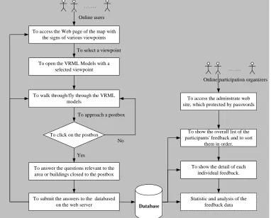
Virtual Reality Modelling Language is the most popular desktop VR technique today, which is able to deliver real-time interactive 3D models with realistic texture over the Internet. In this project, VRML technique was adopted to create the 3D models, which represent the West Cambridge master plans. A creative approach to incorporate people’s navigations of the VRML models and their participation activities is also applied in this research project. The diagram below (Figure 1) shows the overall structure of this virtual reality participation system.
Online users
To access the Web page of the map with the signs of various viewpoints
To open the VRML Models with a selected viewpoint
To walk through/fly through the VRML models
...
To answer the questions relevant to the area or buildings closed to the postbox
To click on the postbox
Yes
No To select a viewpoint
To approach a postbox
To submit the answers to the databased
on the web server Database
Online participation organizers
...
To access the adminstrate web site, which protected by passwords
To show the overall list of the participants' feedback and to sort
them in order.
To show the detail of each individual feedback.
Statistic and analysis of the feedback data
Figure 1 The overall structure of the virtual reality participation system
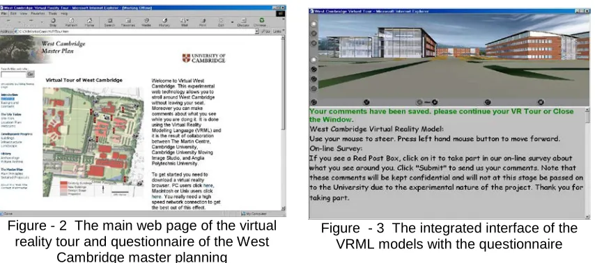
post-boxes. The clickable signs of camcorders indicate the different initial viewpoints of the VRML models, which enable users to quickly access the locations or facilities, which they want to go. Seven different starting viewpoints are pre-set in the West Cambridge models. They can quickly lead users to the following seven important locations or facilities highlighted this master planning (Figure 2).
1. The main road to access this new campus.
2. The new car park for the West Cambridge campus 3. The Computer Laboratory Building
4. The Microsoft Building
5. The Marconi Building (now known as the CAPE Building). 6. The view toward the proposed East-Forum Buildings 7. The footpath leading to the City Centre of Cambridge.
The signs of the post-boxes indicate the question points, which strongly related to those seven locations on the site. For the users who view VRML model files at first time, they have to download and install a VRML viewer into their PCs. In this case, the Cortona VRML viewer developed by the Parallel Graphics is recommended by the web master. It is free to download. However, other VRML viewers, such as the Cosmos VRML viewer, can also be used to view the West Cambridge VRML models.
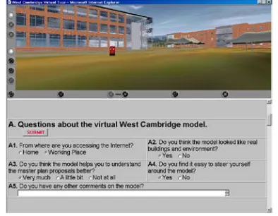
Once a user clicks on a sign of the camcorder on the map (Figure 2), a new window with the 3D VRML models (Figure 3) will be loaded on his PC with the starting viewpoint he chooses. In Figure 3, the window is split into two parts. The up section is the VRML models with the navigating functions of the Cortona VRML viewer. The lower section is the text window, which contains the operating instruction and the questionnaires. The operating instruction gives users the brief instruction on how to use mouse to navigate the models. Users can simply move the mouse up or down to move forward or backward, and left or right to turn the viewpoint around. They can walk through or fly through anywhere on the planning site. Users can also change the parameters in the property set of the
Figure - 2 The main web page of the virtual reality tour and questionnaire of the West
Cambridge master planning
Cortona viewer to adjust the resolutions of the images and the navigating speeds. In this case, the Cortona VRML model viewer is set not to allow users to walk through the objects in the scenes, such as walls, windows and so on. This simulates the situation in the real world. However, users can use the “fly through” function to cross wall, windows, and closed doors to get to the inside of a building. The certain details (main structures) of the inside spaces of the buildings are modelled in this project. This gives users an opportunity to view the outside environments from a viewpoint in various stories within a building. A detailed view of this West Cambridge models is shown in Figure 4. Online participants can see what the plan and building design exactly looks like in the virtual world before the construction of the planning and design is actually started. This 3D virtual environment obviously can enable people’s much better understanding than 2D planning drawings.
A creative approach to merge people’s navigation of the 3D VR models and their participation activities together is applied in this project. It is to set up a number of questioning points in the VR models, which are represented as the clickable post-boxes. By clicking on one of these post-boxes during their navigation of the models, online participants will be asked to fill a group of questions related to the scenes near to this post-box (Figure 5).
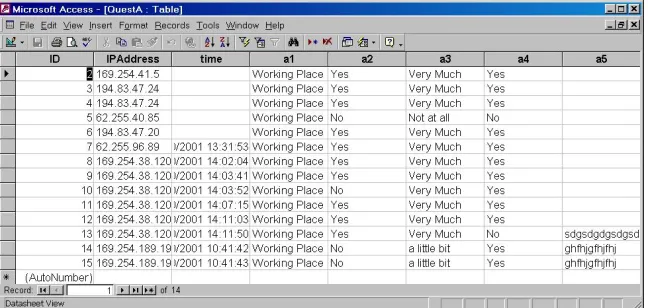
Once the questions have been filled, users can submit their answers to the database on the web server. The Microsoft Access database system is applied in this application to store the feedback from online participants. Active Server
Figure 5 The VR view with the relevant questions
Pages (ASP) technology is adopted to program the applets, which conduct the database operations, such as add or delete a record to a database table, query or sort the database records, and so on. Figure 6 below shows the records of the database table, which were collected from the online question survey in the period of the system test. In order to support the analysis of public participation feedback, some additional information are also collected or added in the database. For instance, ID is a unique code assigned to each record to ensure that each record is unique in the database table; the IP Address stores each user’s IP address as they submit their answers. These IP addresses can be used to roughly identify users’ locations or to tell if the user is in the University; the time can be used to analyse the distribution of the time, at which people access this web site.
3. Discussion
This virtual reality participation system was not applied in practice in this project due to a number of reasons, mainly the delays in the East Forum development, which was initially supposed to be the case adopting this system. However, the broad discussions have been made among the project team and the various stakeholders involved in the master planning of the West Cambridge Site, such as the representatives of the Estate Management Department of the University, the planners and architects, the owners and users of each individual building, and so on. And a number of tests were also conducted by the research team to exam the usability and functionality of this system. Both positive and negative issues of this VR application have been addressed through these discussions and tests as follows:
In comparison of the other representation media, which are conventionally adopted in the representation of urban planning and architectural design, some advantages of virtual reality representation can be addressed as that the representation media of virtual reality technology is fundamentally far more effective to enhance the public’s understanding of professional planning and design, than the conventional media, such a pictures or animation video clips, which are either static or produced in the fix viewpoint traces. The VRML
technique provides users with the full controls on the movement of viewpoints from any directions. The viewers of VRML models, such as Cortona, Blaxxun, Cosmo and so on, are free downloaded. This enables the VRML model more accessible to the general public without any extra costs.
The VR technology can also enable virtual reality models to have some reactions to the actions of user’s navigation. This will make 3D virtual reality models more attractive and realistic. This can offer users the perception of playing a game. It can attract the interests of younger generation’s participation.
The questioning functions merged with users’ navigation of the VRML models provide users the convenience to answer these questions more easily and accurately, because the questions which users are requested to answer are strongly related to what users see in this case. However, in order to set up the appropriate questions and the targets of the online survey, it is crucial for the project managers, the master planners and the architects to work together closely.
On the other hand, some negative issues were also raised in the discussions:
The size of the VRML model files
The final size of this VRML file is about 6 MB; and the texture image files are about 3 MB. Such large size (10 MB in total) of the VRML models is obviously not suitable to the dial-up Internet users and even some broadband users outside the University network. However, this problem can be resolved or reduced through the modelling techniques and the displaying techniques. Firstly, the original CAD models were created according to the architectural drawings of these buildings. Consequently, the certain details of the interior structure have been made in these building models. Due to this project focusing on the urban environment planning issues, some of these interior details can therefore be simplified or deleted to reduce the final size of the model file. Secondly, the VR models of some buildings existing on the site can be modelled by Photogrammetry techniques, rather than creating physically geometric CAD models. Thirdly, the Level of Detail (LOD) methods and techniques may also be used to control partially displaying of the details of VR models on users terminals. This can reduce the problem of downloading the VR model files with large sizes.
The quality of the images of the VR models
effective way to achieve higher quality of VRML models is to use more powerful computer and faster speed Internet connection.
The download and installation of the VRML browsers
Some people in the discussions expressed their worries on the difficulties of users’ downloading and installing of some VRML browsers, such as Cortona, Blaxxun, Cosmo. This could be a barrier to the people, who have not much experience and knowledge of using computers, and may bring some inconvenience to online users to access the VR models. This may be improved through directly linking to these browsers’ downloaded addresses and providing people with more clear and detailed instructions of the installations of these applets. However, due to this project aiming to consult with the member of the University, it seems not to be a serious problem to the student and staff in the University to download and install a small applet. This needs to be verified in the practical case studies.
4. Conclusions
This study effectively implements virtual reality technology in visual representation of urban planning and design for the public participation, and systematically merges other relevant technologies, such as ASP, to enable the online survey associated with the interactive navigation of the virtual reality models. The specific functions are also provided in this system to facilitate people’s participation activities. Both the advantages and disadvantages addressed though the discussions of this project are depicted. Some possible solutions to these, which are based on current technologies, are also suggested. Although this virtual reality participation system was not applied in the real participation practices due to various reasons, it was a great experiment and study for this research project. The experience addressed in this study can obviously support the development and implementation of virtual reality in web-based public participation in future. Today, with booming of using the broadband Internet connections and more powerful PCs, the planning and design representation based on virtual reality technology will be more and more practical to the web-based public participation. It is also believed that more desktop VR techniques will also be developed to be the solutions to the problems suffered in the current application of VR technology to represent large-scale urban environments.
REFERENCES
Batty, M., Chapman, D., Evans, S., Haklay, M., Kueppers, S., Shiode, N., Smith, A., Torrens, P. (2000) Visualizing the City: Communicating Urban Design to Planners and Decision-Makers, http://www.casa.ucl.ac.uk/visualcities.pdf.
architecture, construction, design, civil engineering and urban planning, Pages: 13-22.
Cerreta, M., Torre, G. (2000) Use of Cognitive Mapping for Scenario Construction in Multicriteria Evaluation Methods: An Application for Urban Rehabilitation, Proceeding of the 5th International Conference of Design and
Decision Support Systems in Architecture and Urban Design, Nijkerk, The Netherlands, August 22-25, pp 49-68.
Ennis, G., Lindsay, M., Grant, M. (1999) VRML Possibilities: The Evolution of the Glasgow Model, in the proceedings of the VSMM '99, Dundee, Scotland
Richens, P., Trinder, M. (1999), Design Participation through the Internet: A Case Study, Journal of Architectural Research Quarterly, Volume 3, number 4.
Ruffle, S. (2002) Web-based Participation for Campus Scale Project Design – Final Report of the EPSRC Project, unpublished.
Ruffle, S., Richens, P. (2001) Web Based Consultation for Cambridge University's Building Program. Proceedings of the Twenty First Annual Conference of the Association for Computer-Aided Design In Architecture, Buffalo, New York, 11-14 October 2001, pp366-371.
Sanoff, H. (2000) Community Participation Methods in Design and Planning. John Wiley & Sons, Inc., New York.
Hudson-Smith A., Evans S., Batty M., and Batty S. (2002) Online Participation: The Woodberry Down Experiment, CASA working paper,
http://www.casa.ucl.ac.uk/ working_papers/paper60.pdf