Urban Modality
Modelling and evaluating the sustainable mobility of urban areas in the city-region
01
Urban Modality
Modelling and evaluating the sustainable
mobility of urban areas in the city-region
Jorge Gil
Delft University of Technology, Faculty of Architecture and the Built Environment, Department of Urbanism
abe.tudelft.nl
Design:Sirene Ontwerpers, RotterdamCover: “Crossing”, Floris Oosterveld (modified levels, contrast and focus)
ISBN 978-94-6186-608-0 ISSN 2212-3202
© 2016 Jorge Gil
All rights reserved. No part of the material protected by this copyright notice may be reproduced or utilized in any form or by any means, electronic or mechanical, including photocopying, recording or by any information storage and retrieval system, without written permission from the author.
Unless otherwise specified, all the photographs in this thesis were taken by the author. For the use of illustrations effort has been made to ask permission for the legal owners as far as possible. We apologize for those cases in which we did not succeed. These legal owners are kindly requested to contact the publisher.
Urban Modality
Modelling and evaluating the sustainable
mobility of urban areas in the city-region
Proefschrift
ter verkrijging van de graad van doctor aan de Technische Universiteit Delft,
op gezag van de Rector Magnificus prof. ir. K.C.A.M. Luyben, voorzitter van het College voor Promoties,
in het openbaar te verdedigen op 23 februari 2016 om 15:00 uur door Jorge Albeerto LOPES GIL
Architect, Faculdade de Arquitectura, Universidade Técnica de Lisboa, Portugal MSc Built Environment: Virtual Environments, The Bartlett, University College London
Dit proefschrift is goedgekeurd door de
promotor: Prof. V. Nadincopromotor: Dr. ir. S.A. Read
Samenstelling promotiecommissie bestaat uit
Prof. dr. B. Van Wee, voorzitter
Prof. V. Nadin, promotor
Dr. ir. S.A. Read, copromotor
Onafhankelijke leden
Prof. dr. W.A.M. Zonneveld, BK, TU Delft
Prof. M. Batty, University College London
Prof. Lars Marcus, Chalmers University of Technology
Dr. D. Stead, OTB, TU Delft
Dr. E.J. Meijers, OTB, TU Delft
This research was funded by the Portuguese Science and Technology Foundation (Fundação para a Ciência e Tecnologia) under the POPH/FSE and QREN programmes, with an individual research grant from 2009 to 2013 (SFRH/BD/46709/2008), and with the ‘City Induction’ project grant from 2007 to 2011 (PTDC/AUR/64384/2006), which is thankfully acknowledged.
Preface
When living in different cities, or different neighbourhoods within a metropolitan region, we experience locally dominant travel patterns: some places seem to be made for walking, other places can only be lived by driving or cycling, and others are dominated by public transport. London is a city of public transport, Amsterdam is a city of bicycles, and Lisbon is a city of cars for anyone living outside its centre, which is largely walkable. We might struggle to import into different neighbourhoods a preferred way of travelling in our daily routines, and it is often required that we learn and adapt to what each place has to offer. And at different stages of our lives we might choose to move to a different neighbourhood, in order to accommodate the travel needs of our changing lifestyle. Each urban environment seems to have natural modes of travel supported by its infrastructure and urban morphology, a ‘modality’.
The car has been dominant in metropolitan areas for the previous decades, and urban development both at the regional and local scales has privileged its use. In many urban areas, public transport is a marginal alternative, pedestrians are at best an afterthought, and the bike is not even considered as a real (utilitarian) mode of transport. And the car infrastructure, once in place, actually hinders the use of those alternative modes of transport. Presently, personal mobility is being discussed and implemented by the built environment and transport professions in a context of sustainable development. It is accepted that it must be predominantly multimodal: combining different modes of transport for different purposes and travel distances, making greater use of soft modes and public transport, and ultimately replacing the use of the car. However, one is faced with cities and neighbourhoods shaped by a legacy of car infrastructure that organises the metropolitan regions and guides people’s daily routines. And one is relying on models of sustainable neighbourhood development focused on the local walking environment, but giving limited consideration to
multimodal travel in the wider context of the city-region. While public transport might be introduced locally, it is often insufficient to offer a real alternative for longer distance travel that can be successfully embraced by the general population.
The motivation behind this research has been to understand how a region is structured by its mobility infrastructures, supporting the different modes of travel, and to explore how the local neighbourhoods relate to this multimodal structure. And in doing so, to start to understand how this structure contributes to the neighbourhoods’ natural modality, and promotes or constrains the success of new sustainable urban developments. Having previously worked with urban models that focus on individual transport modes (pedestrians and cars), the main aim was to develop an integrated urban model of multimodal infrastructure networks, and analyse the configuration of each mode and their integrated effect in the region. Combining such an instrument
with the present spatial models of sustainable urban development, I hope to obtain a more comprehensive description and understanding of urban areas that supports interventions in existing areas, and the planning of new ones, towards viable solutions for sustainable travel patterns.
Acknowledgements
A research of this nature would have never been possible without the direct or indirect support of many people:
–
My supervisors at the TU Delft Department of Urbanism, Vincent Nadin and Stephen Read, for their academic experience, sound advice, inspiration, and persistence.–
The external members of the defense committee, Bert van Wee, Mike Batty, Lars Marcus, Will Zonneveld, Dominic Stead and Evert Meijers for their availability to review and discuss this work.–
The journal editors and conference organisers, who enabled the publication and wider dissemination of this work, and all the reviewers involved, who provided important comments to improve the quality of the research.–
The ‘City Induction’ project team at the TU Lisbon, José Pinto Duarte, José Nuno Beirão, Nuno Montenegro and Júlio Almeida, for pushing me into this adventure, and for many stimulating discussions and work collaborations.–
My colleagues at the TU Delft, Verena Balz, Bardia Mashoodi, Dena Kasraian, Pirouz Nourian, Alex Wandl, Birgit Hausleitner, Egbert Stolk, for their companionship in sharing the struggles of PhD life, but also the enthusiasm of sharing new ideas, methods, articles and data sources. And for their hospitality on many occasions.–
My friends and fellow PhD researchers Miguel Serra (my PhD buddy), Alain Chiaradia, Stephen Law and Pete Ferguson, for sharing, reviewing and discussing our related research and ideas.–
Many other researchers whom I met personally or had contact with remotely, who gave useful feedback, asked relevant questions, made suggestions, or gave encouragement to carry on.–
The administrative staff of the TU Delft Department of Urbanism, Amber, Karin, Linda and Danielle, for ensuring the best possible hospitality over the years.–
The developers and contributors of open source software, volunteered geographic information and open data platforms. In particular, the staff at the DANS data archive (Netherlands).–
All my friends and familly, for sharing laughs, food and drink, and reminding me that there’s much more to life than (PhD) work.–
My parents, Nuno and Maria Cândida, for their unconditional support and love, at every stage of my life and academic career.–
And my partner Raquel, and my daughters, Clara and Alice, for their patience, and making the desire to enjoy their company the main motivation to finish this work.Contents
Summary 21
Samenvatting 23
1
Introduction
271.1 Background 28
1.1.1 The goals of sustainable transportation and mobility 29
1.1.2 The role of urban form 31
1.1.3 From transit-oriented development to multimodal urban-regional development 34
1.2 Problem Statement 40
1.3 Research aim and questions 42
1.3.1 Research questions 42
1.4 Audience and relevance 44
1.4.1 Societal relevance 44
1.4.2 Scientific relevance 45
1.5 Approach and key concepts 47
1.5.1 Evaluation framework 47
1.5.2 Sustainable mobility indicators 48
1.5.3 Urban form and accessibility indicators 50
1.5.4 Spatial network analysis 52
1.5.5 Urban modality: from description to synthesis 55
1.6 Research design and methods 56
1.6.1 Case study 58
1.6.2 Spatial data framework 61
1.6.3 Quantitative methods 65
1.6.4 Software tools 67
2
Tools for the evaluation of sustainable urban design: a review
173 2.1 Introduction 74
2.2 The evaluation of sustainable urban design 75
2.3 An analytical framework for SUD evaluation tools 76
2.3.1 Tool format 77
2.3.2 General tool structure 77
2.3.3 Tool content 79
2.3.4 Tool output 80
2.4 Selecting a relevant set of SUD evaluation tools 81
2.4.1 The sources of information 81
2.4.2 Tool identification and selection 82
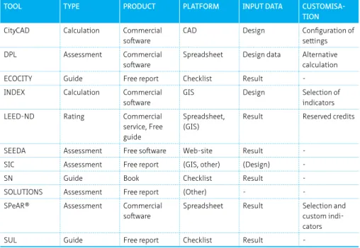
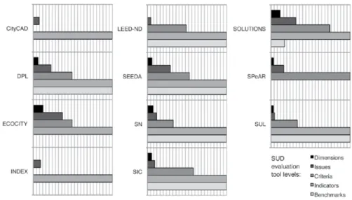
2.4.3 Summary of the selected tools 84
2.5 Review of the selected tools 86
2.5.1 Format of the tools 87
2.5.2 Configuration of the tools 88
2.5.3 What are the tools measuring? 89
2.5.4 Output of the evaluation results 92
2.6 Discussion 94
2.7 Conclusions 95
1 Based on the manuscript of: Gil, J. and Duarte, J.P. (2013). ‘Tools for the evaluation of sustainable urban design: a review ‘. Proceedings of the ICE - Urban Design and Planning 166 (6), pp. 311–325.
3
On the discovery of urban typologies:
data mining the many dimensions of urban form
297 3.1 Introduction 98
3.2 Quantitative classification of urban typologies 99
3.2.1 Systematic classification using data mining techniques 100
3.3 A method for the discovery of urban form types 101
3.3.1 Representation 101
3.3.2 Analysis 102
3.3.3 Description 103
3.4 Demonstrating and testing the method 103
3.4.1 Representation 103
3.4.2 Analysis 105
3.4.3 Description 107
3.4.4 Results 109
3.5 Discussion 110
3.5.1 Parametric rule-based design structures 111
3.6 Conclusions and further work 111
2 Based on the manuscript of: Gil, J., Beirão, J.N., Montenegro, N., Duarte, J.P. (2012). ‘On the discovery of urban typologies: data mining the many dimensions of urban form’. Urban Morphology 16 (1), pp.27–40. (Main author, 85% contribution)
4
Building a Multimodal Urban Network Model Using OpenStreetMap
Data for the Analysis of Sustainable Accessibility
3113
4.1 Introduction 114
4.2 The structure and infrastructure of a multimodal urban network model 115
4.2.1 Data and software stack 117
4.2.2 Spatial data model 118
4.3 Creating the private transport system 119
4.3.1 Street network segment classification and correction 120
4.3.2 Street intersection node classification 122
4.3.3 Pedestrian areas links generation 122
4.4 Creating the public transport system 124
4.4.1 Public transport networks preparation 125
4.4.2 Public transport network interfaces generation 128
4.5 Creating the land use system 129
4.6 Results 130
4.6.1 Multimodal network model analysis 131
4.6.2 Multimodal network model reflections 134
4.7 Conclusions 135
3 Based on the manuscript of: Gil, J. (2015),’Building a multimodal urban network model using OpenStreetMap data for the analysis of sustainable accessibility’. In: Jokar Arsanjani, J., Zipf, A., Mooney, P., Helbich, M. (Eds.), OpenStreetMap in GIScience: Experiences, Research, Applications, Lecture Notes in Geoinformation and Cartography. Springer, Berlin, Heidelberg, pp. 229-251.
5
Analyzing the Configuration of Multi-modal Urban Networks
4137 5.1 Introduction 138
5.2 Street network models and their analysis 140
5.2.1 The analysis of street network models 140
5.2.2 The geographies of street network models 141
5.2.3 The graphs of street network models 142
5.2.4 The impedance of street network models 142
5.3 The multimodal urban network model 143
5.3.1 The geographic representation of the MMUN model 144
5.3.2 Connecting the systems 146
5.3.3 From a geographic network to a graph in the MMUN model 146
5.3.4 Distance in the MMUN model 147
5.4 Implementing a MMUN model of the Randstad city-region using open data 151
5.4.1 Some technical considerations 152
5.5 Analysing the configuration of multi-modal urban networks 153
5.5.1 The urban structure and road hierarchy of the Randstad city-region 154
5.5.2 Testing private transport network flows 157
5.5.3 Testing public transport network flows 159
5.5.4 The integration of networks in multi-modal configurations 160
5.6 Conclusions and future work 162
4 Based on the manuscript of: Gil, J. (2014). ‘Analysing the configuration of multimodal urban networks ‘. Geographical Analysis 46, pp. 368–391
6
Patterns of sustainable mobility and the structure of
modality in the Randstad city-region
5165
6.1 Introduction 166
6.2 Sustainable mobility patterns in the Randstad city-region 167
6.3 The configuration of multi-modal urban networks 170
6.3.1 Multimodal network models in space syntax research 171
6.3.2 Measuring multi-modal network models 172
6.4 The multi-modal urban network model of the Randstad 173
6.4.1 The structure of the model 174
6.4.2 The analysis of the model 177
6.5 The structure of modality of the Randstad 179
6.5.1 Network proximity structure 179
6.5.2 Network centrality structure 181
6.5.3 The relation between modality and mobility in the Randstad 182
6.5.4 The modality environments of the Randstad 184
6.6 Conclusion 188
5 Based on the manuscript of: Gil, J. and Read, S. (2014).’ Patterns of sustainable mobility and the structure of modality in the Randstad city-region’. A|Z ITU Journal of the Faculty of Architecture 11 (2), pp. 231-254. (Main author, 85% contribution)
7
The Sustainable Travel Performance of Urban Areas:
Context-sensitive Evaluation for Strategic Planning Support
1917.1 Introduction 192
7.2 Methodology 194
7.3 Travel patterns and the typologies of urban areas 197
7.3.1 Travel patterns 198
7.3.2 Spatial characteristics 201
7.3.3 Socio-economic characteristics 204
7.4 The travel performance of VINEX neighbourhoods 206
7.4.1 The relation between urban form and socio-economic types 207
7.4.2 Defining the mobility potential of VINEX neighbourhoods 208
7.4.3 Contextual evaluation of mobility performance 209
8
Conclusions
2158.1 A multi-level framework for sustainable mobility policy and practice 216
8.2 Research questions revisited 218
8.3 Other findings 225
8.3.1 Limitations of SUD evaluation tools 225
8.3.2 The challenge of combining different data sets 226
8.3.3 Transport mode’s distance patterns 226
8.4 Considerations on the multimodal urban network model 228
8.4.1 Alternative approaches to network representation 228
8.4.2 Alternative approaches to network analysis 230
8.5 Future research 232
Glossary 235
References 239
Biography 255
Appendix A SUD assessment criteria 259
Appendix B Spatial data model 261
Appendix C Spatil database layers 263
Appendix D Network impedance comparison 281
Appendix E Sustainable mobility profile of the Randstad 295
Appendix F List of urban form and accessibility measures calculated 317
Appendix G Multimodal urban form and accessibility of the Randstad 319
Appendix H Correlation of travel patterns, urban form and socio-economic characteristics 351
Appendix I Descriptive statistics of the urban form typology 363
Appendix J The ‘urban modality’ archetypes 385
Appendix K Results of the sustainable mobility performance evaluation of VINEX SET2 neighbourhoods 401
Appendix L VINEX SET2 neighbourhoods with outlier mobility performance 415
Summary
This thesis proposes a framework for evaluating the mobility potential and performance of urban areas in the city region, as an instrument to support urban development that contributes positively to regional sustainable mobility objectives. The research takes a quantitative approach, modelling and measuring the characteristics of a city-region and of its individual urban areas, in terms of travel patterns and socio-economic characteristics of the resident population, and in terms of built environment characteristics. It then explores how the built environment defines the affordances of urban areas for travelling by particular modes of transport, i.e. its walk-ability, cycle-ability, drive-ability and transit-cycle-ability, by developing a typology of what I call their ‘urban modality’. And finally the work combines this typology with the socio-economic characteristics of urban areas to determine their sustainable mobility potential and performance. It focuses on the case of the Randstad region of the Netherlands and its VINEX neighbourhoods, which are an emblematic example of new urban areas created under a policy programme with sustainable mobility objectives.
A key stance in this work is the understanding that the location of an urban area in the region can be indicative of its population’s travel patterns, because the built environment (infrastructural) and socio-economic characteristics are interrelated and present strong regional spatial patterns. What types of urban areas support sustainable travel patterns, and what are their spatial characteristics? How do new neighbourhoods compare to the best performing urban areas, and to other areas of the same ‘modality’ type? These are some of the questions addressed in this study. There are two main contributions of this research: the methods for building and analysing integrated multimodal network models, and the framework for contextual performance evaluation using urban area typologies.
The integrated multimodal network model combines the various mobility
infrastructure networks and the buildings’ land use to create a detailed description of the region, using open spatial data and open source Geographic Information Systems (GIS) technologies. The network model’s spatial analysis covers local urban form indicators, such as street layout, network density and land use mix, as well as regional indicators of multimodal accessibility and network configuration (its structure), to give a holistic profile of urban areas across modes and scales of travel.
The analysis results go through exploratory data mining and classification procedures to identify urban form typologies of urban areas. It is shown that there is a relation between this ‘urban modality’ of urban areas and the travel patterns of their residents, measured as a set of sustainable mobility indicators related to mode share and distance travelled. For this reason, ‘urban modality’ offers the possibility for ex-ante
evaluation of sustainable mobility potential of planned urban areas. Furthermore, when combined with the socio-economic profile of the resident population, ‘urban modality’ defines a context for the ex-post evaluation of sustainable mobility performance of existing urban areas.
The evaluation of suburban areas together with the more central historical urban areas gives invariably a high score in sustainable travel to the central areas, and rates the suburban areas negatively. On the other hand, the evaluation of sustainable mobility performance in the context of suburban areas of the same type allows the finer distinction of underperformers that have scope for improvement, and overachievers that provide examples of (relative) success. This contextual evaluation can become a decision support instrument for “hard” and “soft” planning measures involving sustainable mobility targets.
Applying this method to the set of VINEX neighbourhoods of the Randstad leads to the conclusion that despite being planned following the same policy objectives, the neighbourhoods have different types of ‘urban modality’, thus present different levels of sustainable mobility potential. Neighbourhoods identified as underperformers within their context can be targeted for soft measures related to transport services, technology and individual attitudes to travel, to fulfil the potential of their ‘urban modality’ type. However, if this potential is not deemed satisfactory or if they already overachieve, only by retrofitting a set of infrastructure and land use characteristics will lead to a different ‘urban modality’ type, and a change in potential. Such a change can be lengthy, costly and sometimes impossible to implement ex-post.
The thesis is based on a collection of published articles in peer-reviewed academic publications, with the first and last chapters providing an overview of the research and of its findings, and defining the main narrative thread.
Samenvatting
In dit proefschrift wordt een kader voorgesteld voor de evaluatie van het potentieel en de prestaties op het gebied van mobiliteit van stedelijke gebieden in de stadsregio. De evaluatie is bedoeld als instrument ter ondersteuning van stadsontwikkeling dat positief kan bijdragen aan regionale doelstellingen met betrekking tot duurzame mobiliteit. In het onderzoek wordt een kwantitatieve benadering gehanteerd: de kenmerken van een stadsregio en de verschillende stedelijke gebieden hierbinnen worden gemodelleerd en gemeten op basis van reispatronen en sociaaleconomische kenmerken van de bewoners, en van de kenmerken van de gebouwde omgeving. Vervolgens wordt onderzocht hoe in de gebouwde omgeving de affordantie van stedelijke gebieden voor het reizen wordt gedefinieerd door middel van specifieke vormen van transport: loopbaarheid, fietsbaarheid, rijdbaarheid en ov-baarheid. Hiervoor is een typologie ontwikkeld van wat ik de ‘stedelijke modaliteit’ van stedelijke gebieden noem. Ten slotte wordt deze typologie gecombineerd met de sociaaleconomische kenmerken van stedelijke gebieden om het potentieel en de prestaties van duurzame mobiliteit van de stedelijke gebieden te bepalen. Het werk richt zich in het bijzonder op de Randstad-regio en zijn Vinex-wijken: een kenmerkend voorbeeld van nieuwe stedelijke gebieden die zijn ontstaan in het kader van een beleidsprogramma met doelstellingen voor duurzame mobiliteit.
Een belangrijk uitgangspunt voor dit werk is het inzicht dat de locatie van een stedelijk gebied in de regio een indicatie kan vormen voor de reispatronen van de bevolking van het gebied, omdat de infrastructurele en sociaaleconomische kenmerken van de gebouwde omgeving met elkaar samenhangen en sterke regionale ruimtelijke patronen laten zien. Welke typen stedelijke gebieden ondersteunen duurzame reispatronen en wat zijn de ruimtelijke kenmerken van deze gebieden? Hoe presteren nieuwe wijken in vergelijking met de beste stedelijke gebieden en met andere gebieden van hetzelfde type ‘modaliteit’? Dit zijn voorbeelden van vragen die in dit onderzoek worden behandeld. Het onderzoek steunt op twee belangrijke pijlers: de methoden voor het bouwen en analyseren van geïntegreerde multimodale netwerkmodellen en het kader voor contextuele prestatie-evaluatie door middel van typologieën van stedelijke gebieden. In het geïntegreerde multimodale netwerkmodel worden de diverse infrastructurele mobiliteitsnetwerken gecombineerd met het landgebruik voor gebouwen, met als resultaat een gedetailleerde beschrijving van de regio. Hiervoor is gebruikgemaakt van vrij beschikbare ruimtelijke gegevens en open-source GIS-technologie (Geografische Informatie Systemen). In de ruimtelijke analyse van het netwerkmodel worden plaatselijke indicatoren voor stedelijke vormen behandeld, zoals stratenplan, netwerkdichtheid en gemengd landgebruik, alsmede regionale indicatoren van multimodale toegankelijkheid en netwerkconfiguratie (-structuur). Hieruit ontstaat
een holistisch profiel van stedelijke gebieden met aandacht voor de verschillende vormen en schalen van vervoer.
De analyseresultaten worden onderworpen aan verkennende datamining- en
classificatieprocedures om typologieën voor stedelijke vormen van stedelijke gebieden te kunnen identificeren. Aangetoond wordt dat er een relatie bestaat tussen deze ‘stedelijke modaliteit’ van stedelijke gebieden en de reispatronen van de bewoners, gemeten als set indicatoren voor duurzame mobiliteit in relatie tot het aandeel van de vervoersvorm en de afgelegde afstand. Hierdoor biedt het begrip ‘stedelijke modaliteit’ de mogelijkheid tot een ex-ante evaluatie van het potentieel van duurzame mobiliteit van geplande stedelijke gebieden. In combinatie met het sociaaleconomische profiel van de bewonerspopulatie definieert ‘stedelijke modaliteit’ bovendien een context voor de ex-post evaluatie van de prestaties van duurzame mobiliteit van bestaande stedelijke gebieden.
Bij de evaluatie van voorstedelijke gebieden vergeleken met de meer historische stadskernen krijgt duurzaam reizen naar centraal gelegen stadsdelen steevast een hogere score, en worden gebieden in de voorsteden negatief beoordeeld. Anderzijds kan, door de evaluatie van de prestaties van duurzame mobiliteit in de context van stedelijke gebieden van hetzelfde type, een verfijnder onderscheid worden gemaakt als het gaat om onderpresteerders met ruimte voor verbetering en overpresteerders met voorbeelden van (relatief) succes. Deze contextuele evaluatie kan uitgroeien tot een ondersteuningsinstrument voor besluitvorming over ‘harde’ en ‘zachte’ planningsmaatregelen met doelen voor duurzame mobiliteit.
Toepassing van deze methode op de Vinex-wijken in de Randstad leidt tot de
conclusie dat de wijken, hoewel ze volgens dezelfde beleidsdoelstellingen zijn gepland, verschillende typen ‘stedelijke modaliteit’ hebben en dus verschillende niveaus van potentieel voor duurzame mobiliteit te zien geven. Wijken die binnen hun context als onderpresteerder worden aangemerkt, kunnen in aanmerking komen voor zachte maatregelen met betrekking tot vervoersdiensten, technologie en persoonlijke attitudes ten opzichte van reizen, zodat ze het potentieel van hun type ‘stedelijke modaliteit’ kunnen waarmaken. Als dit potentieel echter niet bevredigend wordt geacht of als ze reeds overpresteren, kan alleen het achteraf wijzigen van een aantal kenmerken voor infrastructuur en landgebruik leiden tot een ander type ‘stedelijke modaliteit’ en dus ook tot een ander potentieel. Daarmee kunnen veel tijd en geld gemoeid zijn, en soms blijkt het zelfs onmogelijk om een dergelijke verandering ex post te implementeren.
Dit proefschrift is gebaseerd op een verzameling artikelen die in peer-reviewed wetenschappelijke publicaties zijn verschenen. In het eerste en het laatste hoofdstuk wordt een overzicht van het onderzoek en van de bevindingen gegeven, en wordt de belangrijkste narratieve lijn van het werk gedefinieerd.
1
Introduction
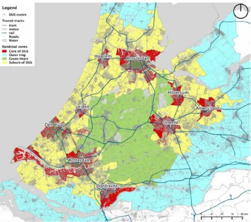
The first chapter of this thesis provides an overview of the research project, and lays out its theoretical and methodological foundations. Given that this thesis is based on a collection of articles, this is a critical chapter in establishing the thread between the subsequent chapters. The introduction starts by setting the background theme of sustainable mobility, explaining its various objectives and the role attributed to urban form in resolving some of the problems brought by the current travel patterns of persons in metropolitan areas. It follows with an overview of existing models of sustainable urban and regional development that focus on addressing the challenges of sustainable mobility. From this we reach the problem statement, which highlights the need to create models to describe and understand the multi-scale and multi-modal complexity of a city-region’s infrastructure and urban form, how this relates to its population travel patterns, in order to plan better functioning city-regions. This leads to the research aims and questions, which are to create an integrated multimodal urban network model to measure the characteristics of urban areas and to evaluate how these compare and perform in light of sustainable urban mobility objectives, followed by statements on the thesis’ audience, societal and scientific relevance. The next section draws together key concepts and approaches that are recurrent in the following chapters, namely contextual urban evaluation, sustainable mobility indicators, urban form and accessibility indicators and spatial network analysis, and it introduces the concept of urban modality. The section on research design and methods moves us to more concrete matters, introducing the specific case study of the present work, namely the urban areas of the Randstad city region of the Netherlands, and providing an overview of the research design and workflow, the data sources and the quantitative methods used. The present chapter concludes with an outline of the individual chapters of the thesis.
§ 1.1
Background
Urban areas and city-regions face serious sustainability problems linked to the current car based personal travel patterns, affecting the environment and the socio-economic fabric of society (Table 1). Since the 1970s, planning policy and guidance has been concerned with these problems triggered initially by the oil, energy and economic crises, and accompanied by an increasing environmental awareness (Meadows et al., 1972; ICT, 1974). This was followed by the consolidation of the triple bottom line concept of sustainability in the Brundtland report (1987) with the inclusion of social concerns. Since then, this integrated perspective is at the basis of contemporary conceptions of and proposals for sustainable development.
To address the problems of transport within a sustainable development framework, we see local, national and supra-national institutions worldwide present their visions on urban mobility in policy and guidance documents setting challenging targets (CLG, 2001; European Commission, 2007, 2011; DfT, 2009; European Council, 2010; Parliament of the State of Victoria, 2010). As an example, the European Commission’s White Paper – Roadmap to a Single European Transport Area (2011) has a set of 10 goals, which includes several specifically related to the movement of persons within city-regions:
“1) Halve the use of ‘conventionally fuelled’ cars in urban transport by 2030; phase them out in cities by 2050;[…]
4) By 2050, complete a European high-speed rail network. […] By 2050 the majority of medium-distance passenger transport should go by rail.[…]
8) By 2020, establish the framework for a European multimodal transport information, management and payment system.”
To achieve such goals we need integrated solutions combining a series of instruments (Table 2), including changes to the mobility infrastructure and, as a consequence, to the spatial structure and form of urban environments. Academic research has in the past couple of decades focused on obtaining evidence on the influence (and its strength) of urban form on travel patterns, and despite identifying the significant importance of socio-economic dimensions and personal attitudes on the individual travel choices, it is accepted that the urban environment provides the conditions for different modes of travel. From this stream of research, ‘Transit-oriented development’ (TOD) has established itself as the standard normative model for sustainable mobility at the neighbourhood scale, while the concept of ‘Multimodal urban regional
development’ offers a theoretical model to address sustainable accessibility, a key objective of sustainable transportation and mobility. The link between sustainable mobility goals and these urban models is explored in the remainder of this section.
§ 1.1.1
The goals of sustainable transportation and mobility
The current mobility trend within metropolitan regions has been for increasing number and longer trips mostly by private car with a wide range of negative impacts. Some impacts are a direct consequence of this trend, namely high levels of energy consumption, CO2 emissions, noise, air pollution, congestion, traffic accidents, and degradation of the urban landscape with transportation specific infrastructure and the use of open space for car parking (Banister, 2005; Black, 2010; Bruun et al., 2012). Other impacts are an indirect consequence of increased car mobility, namely sprawl and the decentralisation of land use, development pressures in rural areas, disinvestment in the public transport sector and increased accessibility inequalities (Banister, 2005; Bruun et al., 2012). These indirect negative consequences have locked us in a ‘vicious circle’ of ‘car dependency’ that further contributes to all other negative impacts, as demonstrated in various studies relating sprawl and low density urban areas to high levels of car use and CO2 emissions (Newman and Kenworthy 1999; Kenworthy and Laube, 1996, 1999; Ewing et al., 2002; Kenworthy 2008).
Sustainable transport and mobility (i.e. transport activity) has been concisely defined by the OECD (2002):
“A sustainable transportation is a transport system that provides “access to people, places, goods, and services in an environmentally responsible, socially acceptable, and economically viable manner.”
And more recently, the European Council (2010) has adapted an expanded definition by the Centre for Sustainable Transportation of Canada (2002):
“A sustainable transport system [is] defined as one that:
• allows the basic access and development needs of individuals, companies and societies to be met safely and in a manner consistent with human and ecosystem health, and promotes equity within and between successive generations;
• is affordable, operates fairly and efficiently, offers choice of transport mode, and supports a competitive economy, as well as balanced regional development;
• limits emissions and waste within the planet’s ability to absorb them, uses renewable resources at or below their rates of generation, and, uses non-renewable resources at or below the rates of development of renewable substitutes while minimising the impact on the use of land and the generation of noise.”
The objectives of sustainable transport and mobility, as discussed by numerous authors are summarised in Table 1.1 (CST, 2002; WBCSD, 2004; Banister, 2005; European Commission et al., 2007; Black, 2010; Bruun et al., 2012), including specific objectives of each general objective.
GENERAL OBJECTIVE SPECIFIC OBJECTIVES
Hazards reduction Reduce CO2 emissions Reduce air pollution Reduce land consumption Reduce urban landscape degradation Reduce noise
Reduce accidents
Travel reduction Reduce energy consumption
Reduce congestion Reduce distance travelled Reduce need to travel
Modal shift Reduce car use in urban areas
Increase walking and cycling Increase share of public transport
Replace medium and long distance car travel by rail Accessibility Maintain or increase accessibility (while reducing
mobility)
Narrow the accessibility divides TABLE 1.1 Summary of the objectives of sustainable transport and mobility
The general objectives of sustainable transport and mobility are: hazards reduction, which includes environmental and personal hazards; travel reduction, which includes travel distance and frequency, but also costs of travel in energy and congestion; modal shift, which involves replacing the transport modes used for travel by others with lower impact in terms of hazards, energy and congestion; and improving accessibility. This last objective is the most complex and integrative because it includes aspects of land use and transport infrastructure (Halden, 2002; Bertolini et al., 2005, Curtis, 2011), and can directly or indirectly impact on the other objectives. Therefore, accessibility is considered to be one of the key objectives of sustainable transportation and mobility and an important indicator to consider when evaluating sustainable development. To tackle this set of objectives we require new policies, planning and design practices for our cities (Wegener, 2007; Banister and Marshall, 2000), based on integrated solutions and policy packages that combine technological improvements at the level of infrastructure and vehicles, regulation and pricing mechanisms, information and education initiatives, and land use and infrastructure development (Priemus, 1995; Newman and Kenworthy, 1999; Banister and Marshall, 2000; Banister, 2005, 2008; Black, 2010; EEA, 2010). Examples of these measures or mechanisms are listed in Table 1.2.
GENERAL SOLUTION SPECIFIC MEASURES
Technology Efficient vehicles
Alternative fuels Road capacity reduction Create cycling facilities
Crossings with priority for pedestrians and bicycles Public transport priority lanes
Increase public transport capacity and speed Park and Ride
Traffic calming Telecommuting
Regulation and pricing Road, vehicle and fuel taxes Reduce speed limits Parking charges Car pooling Area access control
Increase public transport frequency Reduce public transport cost
Information and education Provide real-time information on public transport services
Travel information centres Education in schools
New guidelines in driver training Employee travel schemes
Land use Location of development
Increase accessibility to jobs and services Design of the local urban environment Use of Decision Support Systems in planning TABLE 1.2 List of possible solutions and measures to achieve sustainable transport and mobility
§ 1.1.2
The role of urban form
Urban planning and design provides an integrated platform to pursue important goals of sustainable mobility because changes to infrastructure and urban form are seen as effective measures to achieve goals related travel substitution, travel reduction, modal shift and accessibility. These changes might be slow to implement and to produce results when compared with fiscal, regulatory or technological measures, but they are profound and effective in the long run (Dijst 1997; Boarnet and Crane 1999; Stead, Williams, and Titheridge 2000; Banister and Marshall 2000). Furthermore, the outcomes of these infrastructure and urban form measures are long lasting and difficult or impossible to revert, due to time, cost, resources, or legal constraints (van Wee and Handy, 2014). For these reasons, these spatial factors cannot be ignored or underestimated.
Given the perceived role of urban form in influencing sustainable mobility outcomes (i.e. travel behaviour and/or travel patterns), numerous studies have been carried out over the past two decades to explore this relation and ultimately measure the influence of urban form on travel (for example, Handy, 1992; Ewing, 1995; Cervero 1996; Cervero and Kockelman 1997; Banister et al., 1997; Moudon et al., 1997; Bagley and Mokhtarian, 1999, 2002; Stead, 2001; Bagley et al., 2002; Snellen et al., 2002; Cervero and Duncan, 2003; Boarnet and Crane, 1999; Camagni et al., 2002; Schwanen et al., 2004; Næss, 2005; van de Coevering and Schwanen, 2006; Lee and Moudon, 2006; Chen and McKnight, 2007; Kenworthy, 2008; Marshall and Garrick, 2010, 2012; Silva et al., 2014). There is equally a number of literature reviews providing essential insight into the current knowledge on the relation between urban form and travel, how the problem has been tackled thus far and the conclusions one can draw from that body of work (Cervero and Seskin, 1995; Crane, 2000; Ewing and Cervero, 2001, 2010; Stead and Marshall, 2001; van Wee 2002; van Wee and Maat, 2003; Geurs and van Wee, 2003; Handy, 2005; Cao et al., 2009; van Wee and Handy, 2014).
The main conclusion that emerges from these studies and literature reviews is that the relation between urban form or neighbourhood type and travel is present but the degree of direct influence on travel outcomes is not clear or as strong as expected (for example, Ewing, 1995). In fact, it is acknowledged by the authors that numerous other factors, in particular socio-economic, lifestyle and attitudinal factors, play a fundamental role in influencing residential location choice and in directly determining individual travel behaviour (Bagley and Moktharian, 1999, 2002; van Wee et al., 2002; Bagley et al. 2002; Schwanen and Mokhtarian, 2005; Handy, 2005, 2006; Cao et al., 2006; de Vos et al., 2014). These other factors explain in part the observed relation of travel patterns with urban form and neighbourhood type.
However, from these studies it also becomes clear that it is extremely difficult to establish simple causality between all these factors and travel outcomes (Handy, 2005), even when carrying out longitudinal studies, which are very rare in the field. This is due to the number of factors involved, the complexity of interrelations between those factors (Figure 1.1) and the dynamics of the system as a whole (Bagley et al. 2002). Indeed, urban form, socio-economic and attitudinal characteristics interact and influence each other in bi-directional relationships (Stead et al., 2000; Bagley et al., 2002; Handy et al. 2006).
1 2
FIGURE 1.1 Conceptual models of the relationship between urban form, socio-economic characteristics and travel patterns, 1) Stead et al., 2000 and 2) Handy et al., 2006.
Despite these conclusions, there is widespread agreement that urban form (i.e. land use and the mobility infrastructure), to some degree, has an impact on travel outcomes and at least provides the infrastructural and spatial conditions to make specific travel choices (Handy, 1996) and enact a preferred (more sustainable) lifestyle (Williams et al., 2008). If we observe the spatial distribution of travel in a region (see for example Chapter 7 and the maps in Appendix E), there are clear travel patterns that correspond to specific types of urban area, however one chooses to define these. The fact that, in these studies, land use characteristics show a small effect on travel should also lead to conclusions regarding the selected urban form indicators, such as population density or distance to city centre. One should not draw the general conclusion that there is no influence of the built environment on travel, but instead seek to gain a better understanding and better description of the form and structure of urban areas and neighbourhoods.
In this respect, the provision of accessibility is seen as an important contribution of land use planning and policy to sustainable mobility, in making a range of activities accessible by more sustainable modes of transport (van Wee and Handy, 2004), even if in the short term and for certain individuals this possibility does not determine their travel choices. In this sense, one can say that the urban environment has characteristics that support or hinder the adoption of a sustainable mobility lifestyle and results in specific travel patterns. One should consider the space-time context and population characteristics of the different urban areas rather than simpler aggregate urban form characteristics (van de Coevering and Schwanen, 2006).
§ 1.1.3
From transit-oriented development to multimodal
urban-regional development
Since the 1980’s several urban design models have been proposed for the development of sustainable neighbourhoods and cities, such as eco-city, urban village, traditional neighbourhood development, or compact city. These are inspired by the traditional cities and 19th and early 20th century suburban development in Europe. They share some common principles related to land use, urban form and infrastructure, namely concentrated development, medium to high population density, decreasing from the centre to the periphery, mixed-use, connected pedestrian streets, and availability of public transport (Urban Task Force, 1999, 2007; Dieleman et al., 1999; Kenworthy, 2006). Their focus is primarily on walkable neighbourhood and community development, reviving and adapting the concept and principles of ‘Neighbourhood Unit’ by Clarence Perry (1929) (Figure 1.2.1) (Colison, 1954), translated to today’s neo-traditional neighbourhood development principles, materialised in the ‘New Urbanism’ movement in the United States (Figure 1.2.2).
1 2
FIGURE 1.2 Neighbourhood unit model, 1) original, by Clarence Perry (source: New York Regional Survey, Vol 7. 1929), 2) adapted, by Duany and Plater-Zyberk
One urban neighbourhood development model originating in the US based on this strand of theory and practice is the ‘Transit-oriented development’ (TOD) model proposed by Peter Calthorpe (1989). This model addresses explicitly the issues of sustainable mobility through urban form by prioritising quality public transport as a means to reduce the use of the car when travelling between neighbourhoods. The public transport node takes centre stage in the TOD model, locating high density
development around it with a concentration of commercial and office space. As for the rest of the neighbourhood, one follows similar principles to those of walkable neighbourhoods, offering connected street networks with quality public spaces, and regulating car use and parking. However, TOD specifies a larger neighbourhood radius (half a mile or 800 m) in comparison with that of the ‘Neighbourhood Unit’ model (quarter mile or 400m), in order to accommodate the population requirements of the public transport service (Figure 1.3).
FIGURE 1.3 TOD model diagram, Calthorpe, 1989
Notably, the TOD model is not restricted to defining local neighbourhood urban design characteristics. Calthorpe (1993) developed the TOD model further to encompass the regional scale (Figure 1.4), where several neighbourhood units are distributed in the landscape and interconnected by transportation infrastructure. In this regional model there is a hierarchy of TOD’s (urban TOD and neighbourhood TOD) based on the type of transportation infrastructure available to each one, and they are surrounded by a secondary urban area and nature further afield. Calthorpe consolidates the mobility infrastructure model in the concept of ‘Urban Network’ (2002), where a hierarchy is developed for the infrastructure networks of the car and transit modes, further differentiating the regional field that serves as context for the planning of TOD neighbourhoods, and also differentiating the types of urban development in the region (Figure 1.5).
FIGURE 1.4 TOD model for the region, Calthorpe, 1993
In Calthorpe and Fulton’s ‘The Regional City’ (2001) the focus is on the regional model for TOD, where the authors stress the importance of an integrated regional planning approach between land use and transport. Access to services and jobs is put forward as one of the key descriptors of the region that can be used to differentiate its urban environments and to plan the location and distribution of TOD neighbourhoods of various types. Furthermore, it is stressed that if this relation between land use and transport at the regional level breaks, a carefully designed walkable neighbourhood is most likely to fail to achieve its goal (Calthorpe and Fulton, 2001, p.70). The success of TOD implementations is very much dependent on the integration of the neighbourhoods in a much larger network within a city or city-region (Reconnecting America, 2011). Calthorpe’s TOD model has thus progressed from a simple and well-defined normative (prescriptive) model for the neighbourhood, to a far more complex model for the region. Although the theoretical description of this model in Calthorpe and Fulton (2001) is comprehensive and structured, it is not prescribed to the same level of detail as the neighbourhood model. The regional model offers many nuances, relations and dependencies between its components that are only illustrated by examples and case studies. These complex relational dimensions seem difficult to grasp using the design guide tools and rules on offer in the prescriptive neighbourhood model.
TOD has been used by local governments, urban designers and developers as a prescriptive model for new development and urban regeneration, with many examples documented in numerous publications on sustainable urban form and reviews on TOD (Newmand and Kenworthy, 1999; Dittmar and Ohland, 2003; Cervero et al., 2004; Reconnecting America, 2007; Jacobson and Forsyth, 2008; Curtis et al. 2009; Knowles, 2012), and has been adopted in planning policy and guidance across the globe (Institute for Transportation and Development Policy, 2014). However, this is known to require the adaptation of the TOD model to accommodate differences in planning systems, geographic and cultural differences and local preferences of the population. This transfer of the TOD model to other locations has mixed success, as reported in the case of the Netherlands, with its European and national specificities (Pojani and Stead, 2014). The guidelines from the prescriptive TOD model serve mostly as inspiration and seem to be cherry-picked by different actors, not necessarily producing a coherent and consistent version for local implementation. For planning and design, one needs to move from imported prescriptive models to descriptive models that are inherently context-sensitive (Pojani and Stead, 2015).
These two limitations of the prescriptive TOD model, i.e. the dificulty in specifying the complexity of the region and the context-sensitive requirement for urban design practice, calls for the introduction of different types of operational and conceptual models for regional urban design. Other authors contribute new concepts to the design of the city-region to achieve successful and sustainable urban development (Dijst, 1997; Cervero, 1998; Frey, 1999). According to these authors, the metropolitan
region should be understood as a network structure, a complex relation of multiple centres. Furthermore, these centres are part of and organised through a hierarchy of multiple infrastructure networks, supporting the activities of the local centres and neighbourhoods (Bertolini and Dijst, 2003; Hall and Pain, 2006; Read and Bruyns, 2007; Read, 2009; Read and Sulis, 2010). These conceptual models have similarities to Calthorpe’s regional urban model and can be seen as an evolution of the ABC location policy in the Netherlands from the 1980’s and early 90’s (Dijst, 1997; Schwanen et al., 2004) to the morphological scheme by Bertolini and le Clercq (2003) (Figure 1.6).
1 2
FIGURE 1.6 Diagrams of the 1) ABC development policy of the Netherlands and 2) Multimodal urban-regional development morphological scheme (source: Bertolini and le Clercq, 2003)
However, in these more recent models, accessibility is proposed as an important tool to study the integration of land use and transport at the local as well as regional scales (Handy, 1993; Geurs and Van Wee, 2004; Bertolini et al., 2005; Silva and Pinho, 2010), that eventually can facilitate the description and evaluation of these integrated plans offering a way towards analytic and descriptive urban models. Luca Bertolini and colleagues have proposed several conceptual frameworks to describe and measure the sustainable accessibility of the urban region, as the main goal of planning for sustainable travel patterns (le Clercq and Bertolini, 2003; Bertolini et al., 2005; Cheng et al., 2007).
The ‘Node place model’ (Bertolini, 1999) can be used to classify urban areas in terms of their sustainable mobility potential, based on the balance between the qualities of the local environment (place) value in terms of density and diversity of activities, and the mobility (node) value in terms of quality of public transport service provision. The place
and node values are calculated using custom sets of indicators, defined and selected for each specific study. Therefore, it does not prescribe what a solution should look like, but provides a framework for comparing, evaluating and planning urban areas with an awareness of the regional context.
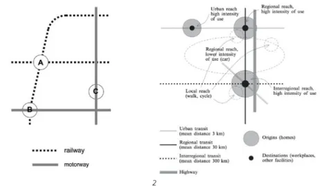
The ‘Multimodal urban-regional development’ concept (Bertolini and le Clercq, 2003; Figure 1.7) offers a framework to classify urban areas in terms of mobility infrastructure and land use characteristics. Such a classification defines the differentiated character of the region based on the different transport modes of its environments: car, transit, walking and cycling, and different combinations of these. The term ‘mobility environments’, more commonly used for local environments of public transport interchange (Bertolini and Dijst, 2003), has also been used to refer to urban areas in the city-region, characterised by their different integration with the mobility infrastructure (Bertolini, 2006). Because the different environments have specific transport mode characteristics beyond a more general mobility potential, I will refer to this as the ‘modality’ of an environment (see section 1.5.5).
FIGURE 1.7 Diagram of the multimodal urban-regional development conceptual scheme, (source: Bertolini and le Clercq, 2003)
From the different local and regional models for sustainable mobility presented, we can extract a general understanding of the city-region that is instrumental for the remainder of this research: a city-region made up of different types of urban areas, organised and defined by the different mobility infrastructures and by their accessibility to people, activities and jobs. Furthermore the regional models highlight the importance of developing planning support tools to make the integrated and relational nature of land use and transport more tangible, with operational models that are adaptable to real cases, beyond the theoretical description and prescription of normative models.
§ 1.2
Problem Statement
To achieve the goals of sustainable mobility of people we need city-regions with an integrated and ‘seamless’ multimodal transport system that articulates neighbourhoods and vibrant city centres, matching the needs of the population, businesses and institutions, while reducing the distance and frequency of trips completed by private car, by shifting mobility to public transport and soft transportation modes such as walking and cycling (Banister, 2008; European Commission, 2007b). However, to create these conditions, we must operate in a framework of complexity:
–
a networked, multi-scale and multi-modal environment;–
with urban form and several other factors interacting;–
establishing non-linear relations with the mobility outcomes.To operate more effectively in this framework, urban design and planning needs to engage with the dynamics of contemporary mobility (of people, information, resources), its multi-modal and multi-speed nature (Ascher, 1995), and requires improved models, methods and tools for research and decision support in practice that:
–
facilitate an understanding of the relational nature and structure of the city-region;–
represent the modality of its urban areas (i.e. walk-ability, cycle-ability, drive-ability, transit-ability);–
are context sensitive and adaptable to different regions and different locations. This is the nature of the challenge that the present work tries to address.The city-region must be understood as a diverse and relational whole, made up of multiple places and multiple levels in a networked rather than an areal structure (Read, 2013). To address the problem of sustainable mobility one should not focus on singular normative concepts that are locked on standards imported from different contexts (Ben-Joseph, 2004); nor on models that only address the local conditions of the environment, such as urban village or traditional urban development, ignoring the position of these places in a wider region; neither on models that define land use from simple areal measurements of the region, e.g. density and distance to city centre, ignoring the structure of the mobility networks and the richness of the local characteristics (Massey, 1991; Healey, 2006). The regional travel patterns emerge from the interactions between a range of different urban areas that form the city-region, and from the activities that happen within those urban areas, supported and organised by the multimodal infrastructure networks that operate at various scales across the region (Dupuy, 2008; Read, 2009). This multimodal urban regional development approach must integrate quantitative measures, such as accessibility, that describe the spatial structure of the regional context, with measures that describe the qualities of the local environment. The city-region is composed of a diversity of urban environments that play different roles in its functioning, and make different contributions to its mobility outcomes.
But, while acknowledging the role of the environment in providing the background conditions, these mobility outcomes are also directly influenced by a range of other factors, such as socio-economic, technological, regulatory, individual attitudes and preferences. The interdependence of these factors leads to non-linear relations between individual factors and mobility outcomes, which confound causality. Empirical evidence is essential to understand the mobility performance of neighbourhoods and regions, but the results of different cases are not immediately comparable, and the studies have been inconclusive or contradictory. A better understanding of the problem requires a context sensitive perspective where multiple methods can be applied to the same case, and the methods are systematic and flexible to be applied effectively to different cases.
Research and practice must use models, methods and tools that are able to operate in this complexity and diversity of the city-region, to support better understanding and strategic decision-making (Healey, 2006; Curtis and Scheurer, 2010; Curtis et al., 2013). Models must depart from constrained normative models and acknowledge the wider regional and geographically specific context. Methods and tools must integrate a wide range of spatial measures and indicators of urban form and accessibility, addressing multiple travel modes and purposes. Methods and tools need to evaluate the empirical evidence available and act on the existing environment, or evaluate urban design and planning alternative scenarios based on principles provided by context sensitive models.
§ 1.3
Research aim and questions
The primary aim of this research is to develop an approach to evaluating the
sustainable mobility potential and performance of urban areas that takes into account the spatial context of the region, in support of strategic urban design and planning with regards to sustainable mobility objectives.
Associated with this aim are a series of secondary aims (or requirements):
–
To develop an analytic multimodal urban network (MMUN) model that measures and describes the spatial structure of the city-region and its individual urban areas;–
To classify the urban areas according to their multimodal spatial structure, integrating the concept of accessibility and configuration with local urban form characteristics;–
To understand how the multimodal spatial structure relates to the travel patterns of the residents of urban areas;–
To deliver these aims in a form that is accessible and reproducible, by using open data and open source software.§ 1.3.1
Research questions
The motivating question that this research will address is the following:
What are the types of urban areas that support or constrain sustainable travel patterns?
From travel survey data it is possible to extract the travel patterns of different locations, and from a sustainable mobility perspective assess their performance. And given a detailed description of the locations in the city-region, it is possible to identify infrastructural characteristics that consistently relate to those travel patterns. Once we characterise urban areas with better sustainable mobility performance, we should address a further question to support strategic urban design and planning:
What are the urban environment characteristics necessary to (re)produce the best preforming urban areas?
Through the course of this research, additional sub-questions are addressed to operationalize the measurement of urban modality, the evaluation of urban areas, and achieve the stated research aims:
How do we integrate the mobility infrastructure of different modes in a regional network model?
Each mode caters for a specific scale of travel, and its infrastructure is set-up accordingly. It is necessary to define a level of detail to represent each mode that is appropriate for the scale of the region, that integrates consistently with other modes, and that is feasible given data and analysis constraints.
How can we analyse this model to produce meaningful descriptions of urban modality?
Multimodal transport models are commonly used in geography and transportation for calculating individual routes or service areas, using the network as a means to get from A to B. However it is less common to calculate and describe the spatial structure of the multimodal network itself.
How can we evaluate the sustainable mobility performance of urban areas to support strategic planning?
Finding that urban areas with fundamentally different spatial and socio-economic characteristics present differentiated sustainable mobility performance might not be surprising. Identifying successful urban types and extracting their spatial characteristics (normative model) can guide the planning of new urban areas towards sustainable mobility goals. While evaluating the actual performance of existing urban areas, given their current spatial constraints, can help deal with mobility problems after the fact, i.e. when existing urban areas fail to achieve those goals.
How do VINEX neighbourhoods compare to traditional inner city areas? And to other suburban neighbourhoods?
VINEX neighbourhoods have been developed as part of national spatial planning policy containing sustainable mobility objectives, and their contribution to these goals has been questioned because the travel patterns of their residents are not necessarily more sustainable than those of other suburban neighbourhoods (see section 1.6.1.1). The most sustainable travel patterns can still be found in traditional inner city areas, but these might have unique characteristics unmatched by other areas in the region. VINEX neighbourhoods should be compared to other urban areas not only in terms of absolute travel patterns, but also in terms of socio-economic and spatial characteristics.
§ 1.4
Audience and relevance
In general, this thesis is targeted at urban design and planning researchers and practitioners with an interest in integrated land use and transport models related to sustainable mobility and sustainable urban form. In particular, it is of greater interest to those applying quantitative methods to the measurement, analysis and evaluation of urban and regional environments, especially those using spatial network models. However, it is eminently multidisciplinary, and the audience can come from a variety of research backgrounds, namely urban planning and regional development, transportation and infrastructure planning, urban design, quantitative geography and geomatics, or other fields involved in urban evaluation, urban modelling, spatial network analysis, or urban data mining. This audience should extend to practitioners involved in strategic planning, master planning, and neighbourhood design and development. All readers, whatever their background, will hopefully find useful insights, guidance and tools in the outputs and conclusions of the various chapters.
§ 1.4.1
Societal relevance
As highlighted in the background section, the current travel patterns, based on the extensive use of the private car, have negative implications in various areas of the environment, society and the economy. In recent years, the concern with sustainable mobility, the desire to increase walking and cycling not only for sustainable transportation but also personal health reasons (Southworth, 2005), and increase the use of public transport, has manifested itself in policy and planning actions at all levels of government, from the supra national to the local (e.g. cycle infrastructure development, sustainable mobility plans, European mobility week), and also in initiatives from non governmental organisations and citizen movements (e.g. Cycle to work day, Critical Mass). While this signals an awareness and willingness to change the current situation, one needs to modify the urban environment and mobility infrastructure, improve the transportation technology, as well as change the attitudes and behaviour of the population. And, in a period of economic and property development crisis, strategic planning must identify priority intervention areas to focus investment. Models and tools that support strategic planning for sustainable mobility play an important role in this (Aultman-Hall et al., 1997; Handy and Clifton, 2001; Curtis and Scheurer, 2010; Curtis, 2011; Curtis et al., 2013; Papa et al., 2013). The proposed multimodal urban network model implemented in a Geographic Information System (GIS), and integrated with an appropriate evaluation framework, is a suitable tool for planning support in the discursive, reflexive, dialectic and participative
process of strategic planning (Curtis, 2011). Such a tool can be used to understand the present conditions and to test scenarios, by creating modified versions of the present land use and infrastructure, thus obtaining new descriptions and evaluations of possible, future conditions. The proposed evaluation framework is an example of such a planning support tool, providing an understanding of the characteristics of existing urban areas in their regional context, and comparing actual performance against potential outcomes determined by this context. This contextual knowledge allows focusing on urban areas with greater untapped potential for change, and identifying the specific type of intervention required. The study demonstrates this approach with an assessment of the VINEX neighbourhoods, identifying critical intervention sites (Chapter 7).
The proposed evaluation framework is based on a system of urban form indicators, which is the format most commonly used in practice for evaluating and monitoring sustainable urban development (SUD). The study reviews existing SUD evaluation tools (Chapter 2) and produces a summary of relevant assessment criteria to be included in comprehensive SUD evaluation frameworks (Appendix A), currently being used in a human services transportation plan by senior planners of the Atlanta Regional Commission, US. Furthermore, the neighbourhood classification framework explores a wider range of possible urban form indicators, integrating those found in existing tools with others used in academic research, related to multimodal accessibility and configuration. This expands the analysis and evaluation scale to incorporate the regional context of urban areas. GIS platforms are becoming more accessible and user friendly, are being widely adopted by local governments to support planning and decision making, and their use is becoming fundamental to comply with data management and sharing standards, such as the EU INSPIRE directive. The GIS model and methods developed in this thesis use open data, volunteered geographic information and open source software that are accessible to all. This makes the work more easily reproducible but also adaptable to other geographic locations, without high financial and technical demands. It also demonstrates the application and value to planning of such data and software tools, encouraging their use and leading to their further development and growth.
§ 1.4.2
Scientific relevance
This thesis develops a multimodal urban network model that is an example of integrated urban model to support the strategic planning of urban areas and regions (Wadell, 2002). This integrated network model brings together concepts and techniques from different research communities to provide an extended and detailed description of the built environment, that reveals the spatial structure of the multimodal city-region.