(PLATES 12-18)
E XCAVATION was conducted by the American School of Classical Studies in
five areas of Ancient Corinth during the spring of 1968.1 Dr. and Mrs. William Biers continued for their fourth season the investigations in the large Roman bath to the north of the modern plateia of the present-day village.2 An excavation training session was conducted for the members of the School during April; at this time limited work was done in the bath that lies immediately east of the Lechaion Road and north of the Peribolos of Apollo.8 The foci of the spring season in the agora were the renewed excavations around the Sacred Spring, that is, in the area immediately south of the foundation of the Captives' Facade, and at the west end of the Roman forum, immediately west of the foundation of the Babbius Monument.4
The fifth endeavor of the spring season at Corinth was an investigation of a month's duration in the Sanctuary of Demeter and Kore, undertaken, by arrangement with Professor Ronald S. Stroud, by Dr. Nancy Bookidis.'
THE SACRED SPRING
As of the end of the spring campaign, 1968, eight architectural phases have been distinguished within the stratified levels of the area of the Sacred Spring; certain of these phases had, as well, at least one or more subsidiary floor levels and fills associated with them. All of the phases do not, of course, span equal intervals of time; some phases, even those that had more than one construction level, may have survived for only a few years.
'I express emphatic thanks to Director Henry S. Robinson for his continuous help and interest in the work being done at Corinth, to Miss Kathryn Butt, Secretary of the Excavations at Corinth, aided this spring by Miss Carola Norton and Mrs. K. Sams, and to Mr. Photios Notes, foreman at Corinth since the death of Mr. Evangelos Lekkas. Thanks are also extended to Mrs. E. Deilaki, Ephor of the Argolid, under whose jurisdiction the excavation falls, for her aid with problems and details that arise in the course of a season's work.
2 The results of the four seasons of excavation in this area will be published separately by the
excavators.
-3 This area was largely excavated in 1929; Robert L. Scranton, Corinth, XVI, Princeton, 1957,
pp. 16-21. It was further cleared during the 1967 spring excavations of the School. The area is still not completely cleared to the Roman levels.
4Thanks are due to Miss Donna Yakel and Messrs. Keith DeVries, Kenneth Sams, and Michael Walbank for their attention to the details of this excavation at the Sacred Spring and to Mr. John Lavezzi for his work at the Babbius Monument. A detailed discussion of the excava- tion around the Babbius Monument is to follow.
5 Miss Bookidis will publish her results separately. I would like to thank the American
Association of University Women for making a grant available to her for excavation work at Corinth this year.
American School of Classical Studies at Athens is collaborating with JSTOR to digitize, preserve, and extend access to
Hesperia
EXCAVATIONS AT CORINTH, 1968 37
t~~~~~~~~~~~~~~~~~~~~~~~~~~OO
STONEf
APSIDAL BUILDING
FOUNTAIN HOUSE
NO TH
SACRED SPRING PHASE I
0 5nmeters
PHASE 1 (Fig. 1)
The spring house of the earliest architectural phase, discussed by B. H. Hill,6 was further examined this year, largely in the area immediately east of the draw basin. The fountain house is a rectangular building constructed against the face of the clay and conglomerate cliff above which, at the northwest, the apsidal building was erected. The fountain structure was built in the cliff at a point where there issued forth a spring or water source, augmented by tunnels dug into the clay (P1. 12, a). The west wall of this structure was set under the conglomerate ledge; through this wall the water collected from the tunnels was channelled into the reservoir of the fountain house. At the east the fountain house projected from the side of the cliff as a free-standing building.
The fountain house was composed of three elements: a reservoir, a long, narrow draw basin that extended along the whole eastern side of the reservoir, and an in antis fa~ade with three piers immediately east of the draw basin. The reservoir was a rectangular room, 5.46 m. north-south by 7.34 m. east-west, measured from wall to draw basin. The north, south, and west walls of the reservoir were built with large, well-cut, rectangular poros blocks; the east wall was probably only a low parapet flush with the west side of the draw basin (P1. 12, a). The reservoir was totally covered by a roof, except for a small portion at the west which took advantage of the natural outcrop of cliff conglomerate. The built roof was supported by three rows of rectangular piers, attested to now only by dressed areas on the floor where the columns once were erected.7
6 The following account owes much to the earlier excavations and studies of B. H. Hill and to his publication of the Sacred Spring, Corinth, I, vi, Princeton, 1964, pp. 116-199. It is suggested that the reader have Mr. Hill's book in hand while reading this 1968 report.
For phase 1, see Hill, pp. 160-174. Although water channel B has been considered later than water channel A (ibid., pp. 146-147) the two should be considered as part of the initial con- struction. The contemporaneity appears from the fact that both run under the poros floor paving immediately east of the draw basin of the fountain house; their relationship is clear both in the area of the paving, where they are visible under damaged slabs, and immediately northeast of the paving, within an early excavation trench. This trench extended from the area just north of the east faqade of the fountain house to a point immediately east of the Hellenistic L-shaped monument (ibid., pl. XVII, no. 31). The trench was excavated to bedrock through at least part of its length, destroying two meters of the northern quarter of the mud altar of phase 3. The form of the trench can be seen in P1. 13, b (scale figure stands within the trench), P1. 14, a, and P1. 16, a, where it runs through the photograph just beyond (south of) the numbered floors and foundation trenches. The cover slabs of water channel A and water channel B (the latter open) are visible in the right hand end of the trench in P1. 16, a.
Also, a change in terminology has been made in the following report from the original publication. Because the fountain house under discussion is now being presented as a typical three element fountain house, I accordingly have made a change in the name of two of the elements. That called reservoir in Corinth, I, vi is now referred to as draw basin. The term reservoir is applied to the paved area west of the draw basin, previously referred to as the fountain house
(PI. 12, a).
7 Cited by B. H. Hill, p. 174. Hill, however, rejects the roofing as part of the first phase of
EXCAVATIONS AT CORINTH, 1968 39
The best place for deternmining the precise position of these piers is on the poros floor paving of the east facade of the building. The paving stretched eastward from the draw basin for a distance of 1.75 nm. On the top surface of the paving slabs, at ca. 1.10 and at 2.62, and at 4.05 m. south of the north anta three rectangular trimmed 4reas or setting beds are preserved where rectangular piers once stood as the columnar elements of the in antis facade. The central pier cutting is the best preserved; this is a smoothed area 0.34 m. square. By using this bed and by restoring on it a pier 0.28 by 0.28 m., one places the axis of the central line of piers at about 0.10 m. south of the east-west axis of the building, but not close enough to the axis of the building to coincide with it. The five piers of the central row are separated by intervals of about 1.50 m. The position of the three westernmost piers is attested by trimmed rectangular areas in the stone paving of the reservoir. The row of piers north of the central line was about 1.20 m. both from the north wall of the reservoir and from the central line of columns.
The piers of the north line also had areas trimnmed for them in the floor paving of the reservoir. The westernmost pier of this line was omitted because the over- hanging conglomerate cliff protruded here and no pier was needed. There is evidence, however, in the floor paving that something once stood on the floor at this point. The evidence for the south row of piers within the reservoir is obscured by over- building; no definite traces of smoothed areas or beddings are now visible.
The west wall of the reservoir had, until recently, two bronze lion head spouts set into it. By means of these the ground water passed through the wall into the reservoir. Although the spouts may be synchronous with the erection of the fountain house, it is only in their second use that they were built into the west wall of the reservoir.8 Originally they may have been in the wall that separated the reservoir from the draw basin and were removed to the back wall of the reservoir when the original plan of the fountain house was abandoned and the reservoir was made directly accessible to those collecting water.
The east facade of the fountain house is a design of three piers in antis built directly on the ground-level paving rather than on a raised stylobate. The paving of the facade served as well for the coping for the east wall of the draw basin. It is
of the original design, were found on the poros paving immediately east of the draw basin, in line with the pier cuttings of the reservoir floor. Since it is custonmary for fountain houses to be covered, e.g., Megara, Perachora, Sikyon, and Glauke and lower Peirene of Corinth, the Sacred Spring should also be restored as roofed in its first period. See, also, B. Dunkley, " Greek Fountain-Buildings before 300 B.C.," B.S.A., XXXVI, 1935-1936, especially pp. 144-151.
directly on this paving that people stood to draw water. Six circular depressions can now be distinguished on the paving and there are two concave areas of wear at the top of the east side of the draw basin north of the central pier. These represent wear from the water jars used at the draw basin. The ones in the paving range in diameter from 0.14 to 0.20 m. More may exist in the paving farther south, now covered, under a Hellenistic monument base and foundation. The wear marks indicate that hydriai or some similar pots, not amphoras, were used at this spring house for the worn spots are deepest at the edge, indicating that the wear was the result of pots with ring bases.
The width of the faqade and the width of the reservoir, 5.46 m. from the inside face of the north wall to the inside face of the south wall, were the same, for the side walls of the reservoir extended eastward without interruption to terminate as the antae of the east facade.
The piers of the faqade carried a triangular pediment. A corner block of the pediment wall of the faqade was found in the excavation, re-used as a patch over a damaged area in the original floor east of the north end of the draw basin.
1. Poros pediment wall block. PI. 12, b.
H. 0.44, Th. 0.25, original L. ca. 1.50 m.
Poros, triangular block with one angle now broken away, back surface preserves cutting from second use. Surfaces of block worn, no plaster preserved. Block undecorated, triangular in shape, originally to form one end of a tympanum wall.
If this pediment block is associated with the east faqade of the fountain house in its original state, the pediment would have been over 0.79 m. tall at the mid- point of the faqade. The western terminus of the ridge of the roof of the fountain house would have fitted into the conglomerate outcropping of the cliff edge into which the fountain house was built (P1. 12, a). Because of this, during the erection ,of the fountain house the Corinthians also erected a wall, of which three courses are still preserved, along the top of the conglomerate ledge (Fig. 1) against which the west end of the roof was able to abut where the conglomerate ledge did not suffice.9 Because this wall followed the edge of the natural conglomerate, it crossed above the northwest corner of the reservoir at a different angle from the orientation of the fountain house itself.
No fragments of the faqade of the fountain house have been found in the excava- tion which allow the restoration of the building with either an Ionic or a Doric faqade. The piers may have been simple and without mouldings; this may also have been true of the epistyle.
A line of wall, partially preserved in two courses, that extends at fountain house ground level northward from the northeast corner of the facade of the building
EXCAVATIONS AT CORINTH, 1968 -41
(P1. 12, b), was originally identified as the bottom steps of a flight that led westward to a cement-paved landing and thereafter northward to the apsidal temple on the terrace of the triglyph wall.
The cement floor and upper flight of steps are to be assigned to phase 3 of the spring; the two courses of blocks originally assumed to have been the bottom steps of a flight of four are to be identified as a socle and a bottom course of a retaining wall of phase 1 of the spring.10 The cement-paved landing was not a stair landing but rather it was a floor that originally stretched eastward under the later triglyph wall line; this then became one with the floors of the mud altars of phase 3 (see below, pp. 45-46). The cement floor of phase 3 continued eastward at an elevation of between 74.779 and 74.69 m., separated from the preserved top of the retaining wall of phase 1 by about 0.58 m. of pebbly fill.
A corner epistyle block (Fig. 2; P1. 13, a) was recovered from a Roman founda- tion at about 19 m. southeast of the apsidal building; this can tentatively be identified as part of the fabric of the apsidal building. The epistyle block was designed for the northeast corner of the east facade. It is 1.476 m. long, 0.44 m. high, and 0.389 m. thick. The front vertical face preserves crowning taenia, two complete regulae and one of half length, the other half of which was carved on the adjoining block. The adjoining epistyle block of the front fagade can be restored as 1.314 m. long, with one complete regula and two half regulae. The faqade would have had two end epistyle blocks, each 1.476 m. long and two mid-faqade blocks, each 1.314 m. long. The complete faqade length at epistyle level would thus be 5.58 m., suggesting a width of entablature that agrees closely with the width of the apsidal building as indicated by the six preserved wall blocks in the apse of the structure."
2. Poros corner epistyle block. Fig. 2; P1. 13,a.
A 771. H. 0.44, W. 0.389, L. (soffit of block) 1.476 m.
Poros, traces of plaster. Complete, taenia chipped, back vertical face cut away at its upper right hand quarter for use in Roman foundation.
Front face has crowning taenia 0.058 m. high, projecting 0.018 m. Two full regulae, 0.309 m.
long, half regula at joint 0.162 m. long, all 0.058 m. high, projecting at top 0.016 m., at bottom
0.018 m., no guttae. Space between regulae, 0.35 m.
Right hand end of block has badly preserved crowning taenia and regula.
Left hand end has anathyrosis, 0.09 m. wide vertical bands, 0.07 m. wide top horizontal band.
Top surface has two setting lines running parallel with front face, first 0.068 m. in from taenia, second 0.119 m., probably for triglyph and metope faces. Two lifting cuttings for rope loops, V-shaped, running at right angles to front face of block, one at 0.30 m. from finished end of block,
10 Hill, pp. 153-155, figs. 90, 91. The confusion of periods here is the result of two things.
The cement floor had been dug through immediately east of the line of the triglyph wall and was
not distinguished in the scarp at that time. Compare Hill, fig. 91 with P1. 12, b. Secondly, it has only been during the excavation of 1968 that floor levels were distinguished at the level of the cement floor east of the triglyph wall. These are the altar floors of phase 3. No floor had previously been recognized continuing toward the east that would have corresponded to the cement-paved floor.
1~~~~~~P
0~~~~~~~~~~~~~~~~~~~~~~~~~~~~~~~~~~~~0
CORNER EPISTYLE. BLOCK
CAT. NO. 2. 2 E
EXCAVATIONS AT CORINTH, 1968 43
other at 0.308m. from end with anathyrosis; cf. R. Martin, Manuel d'architecture grecque, I,
Materiaux et techniques, Paris, 1965, p. 210, fig. 88, examples collected in note 2, p. 210. Device
dated to end of seventh to mid fifth century B.c.
If this epistyle block is considered part of the faqade of the apsidal building, the structure must be restored as tristyle in antis. Such a design is definitely attested for the fasade of the fountain house of the first phase of the Sacred Spring. The apsidal building is of about the same date, of slightly narrower width, and part of the same religious complex as the fountain house. It may be that the close relation- ships between the two buildings demanded a similarity in their appearance, at least in their faqades.
PHASE 2
Little was determined about phase 2 of the Sacred Spring, except that the roof of the fountain house and reservoir was dismantled, that the drain that carried off the water from the south of the Sacred Spring was repaired with a large slab of conglomerate bedrock, and that the pediment block of the fountain house was laid down as a step block over a damaged area in the paving. In this phase 0.23 m. of earth accumulated over the original poros slab paving east of the draw basin. It may be that an earthquake had caused the bedrock ledge over the west end of the fountain house to break loose. Sometime afterwards the fallen fragment of con- glomerate was removed to its present place over the drain. This operation would well have demanded the drastic alteration of the reservoir and, perhaps, the removal of the columns of the reservoir and faqade.
PHASE 3 (Fig. 3)
It is within the levels of phase 3 that this season's excavation first revealed the full dimensions of the Sacred Spring complex; the levels beneath this are still largely covered and unexcavated.
The north limit of the temenos is defined by the horos stone carrying its prohibition to trespassers: pU-) KCaa3j6/3acoKETK& (a/cta 11111111 (Hill, pp. 143-144, fig. 84).
To the east of this horos stone the northern limit of the temenos is defined by a line of stone curbing, to the west of the horos stone by the wall of the ramp that leads up to the triglyph terrace and to the apsidal building. The western limit of the temenos may have been formed by the triglyph wall and the fountain house or it may have been limited farther west by some barrier on the triglyph terrace itself. The south side of the temenos was defined by a mud brick wall built on a socle of river rocks. This ran parallel to and ca. 23.30 m. south of the wall of the ramp at the north side of the temenos. The eastern limit of the temenos probably was the west side of the
APSIDAL BUILDING
,//
;/t/
'/5.4 74 79*~.8=74
7446-.
74iO3~~~~~
RESERVOIR 77?.0.
4~~~~~~~~~~~~~~~~~~~~~~~~~~~~~~T.3
tN7THSCwEMU ALWL
A~~~~~~~~~~~~~~~~~~~~~~~~~~~7.0 oo --
NCS
SACRED SPRING - PHASE 3
O 5reters
EXCAVATIONS AT CORINTH, 1968 45
by a disturbance (P1. 15, c) over the large classical drain that ran from the race course area to the northeast and the Peribolos of Apollo. The disturbance appears to have been made at two different times, the first in late Roman, the second in the late Byzantine period, and extends over the top and well down along the west side of the classical drain. It is from within the whole excavated portion of the disturbance that many marbles have been recovered, a number of which appear originally to have been part of the Captives' Facade (P1. 15, b).12
There is more concrete evidence from architectural phase 4 than from phase 3 that the east edge of the temenos extended to the west side of the roadway. The space defined as the temenos in phase 3 appears to have been 23.30 m. north-south by between 22.00 and 38.00 m. east-west.
An altar of mud (Pls. 13, b, 14, a, b) was constructed within the above described temenos and rebuilt at least three times during phase 3. The south end of the latest of these altars was built 4.40 m. east of the draw basin of the Sacred Spring; its north end (P1. 14, b) was 7.75 m. east of the stair that led into the area from the terrace above the triglyph wall.
The latest of the four mud altars was 8.75 m. long, 0.88 nm. wide, and between 0.267 and 0.296 m. higlh. It had a greenish tan mud plaster surface coat. All edges were well rounded, and the top surface was heavily fire-scarred along its complete length. At least three earlier altars, each superimposed on the previous one, still remain almost completely covered by the latest of the series. Each altar has a thin level of ash associated with it around its base and spreading out over the floor. Other evidences of sacrifice were found, including animal skulls and purposely cut bones in the fills immediately to the east and to the west of the altars.
Immediately east of the altars in an area of about twenty square meters, 145 holes were found which perforated the next to latest floor that can be associated with the altars (Fig. 3). These holes range in diameter from 0.03 to 0.20 m. The majority, however, have a diameter of between 0.08 and 0.10 m. Certain of the holes of this level were made by digging pits larger than necessary, which thereafter were refilled
12 Some architectural sculpture, such as a balustrade whose wall thickness is ca. 0.08 m. and a
fragment of an epistyle block, appear to have been originally part of the Captives' Faqade. The
balustrade had a crowning moulding of carved bead and reel under an ovolo on one side, a cyma
reversa with Lesbian leaf as the crowning moulding on the other. One panel or set of panels had swags of fruit, S-2915. Others had boukrania with swags and Victories: boukranion with swag, S-2934; head of Nike, S-2925 (PI. 15, b); arm, wing, and trace of Lesbian leaf on top back of fragment, S-2916; hand, S-2917; arm, S-2919; wing, S-2918. There is also a coffer fragment, A-572, as well as four fragments of one type of marble sima with lion's head spouts, flowers, and akanthos, A-748 through A-751, probably early Roman and not from the Captives' Faqade.
Of the over size sculpture, there are two hands, S-2914 executed in the technique of the two male captives of the faqade, and S-2913; an upper arm fragment in Ionic chiton, S-2920;
fragments of neck and hair, S-2921 and S-2922, of workmanship and scale similar to that of the
with crushed poros in order to secure a stake or spike firmly. The lined holes may have been necessary because the floor immediately east of the altar was extremely hard; a wood stake hammered into this floor might not have been able to penetrate to a depth sufficient for the purpose that the stake was to serve. Most of the holes were found apparently purposely refilled, for large stones, rocks, or coarse sherds had been stuck into them after the stakes or poles had been removed.
West of the altar and north of the reservoir of the fountain house, the access between triglyph wall terrace and the temenos of the mud altar was achieved by a stairway, partially built against and partially cut into the conglomerate ledge, the southward extension of which forms the natural roof ledge over the western end of the reservoir. This stairway is a series of five steps 13 which ascends northward to
the terrace from the cement floor at the north of the reservoir of the fountain house. This cement floor stops at the south against the north wall of the fountain house and the cement is preserved rising to a height of 0.095 m. on the north face of the wall. It may be that at this period water was drawn from over the north wall rather than from the east where the spring house faqade on ce had been. Such a solution might explain why this area was paved with a cement floor and why the south end of the altar could be built so close to the eastern limit of the reservoir.
PHASE 4 (Fig. 4)
The torth, east, and west limits of the temenos appear to have remained those of phase 3; only the southern limit was changed. Here the mud brick temenos wall of phase 3 was dismantled. No definite south wall to the temenos has been identified for period 4. It may still lie under unexcavated fills farther south.
A curb of poros blocks with an unbroken south face (P1. 15, c) stretches east- west within the confines of the temenos, 19.60 m. south of the northern limit of the area. The blocks are of uneven thickness, from 0.16 to 0.22 m. wide, thus producing an uneven north face to the curb. This curb is preserved for a length of 17.60 m., starting 10.90 m. east of the reservoir of the fountain house, which was still in use in the fourth phase. Disturbances post-dating the laying of the curb make it impos- sible to tell whether or not the curb once did extend farther west and closer to the reservoir. A late Roman trench at the south of the Roman propylaea destroyed the curb at the east. The temenos could not, however, have extended much farther to the east for it would have encroached upon the classical north-south road that passed east of the North Building and up to the area of the race track south of Peirene. This road itself probably formed the eastern limit of the temenos.
The curb may have served as a dividing line immediately south of which it was possible to erect temporary market or festival stands, bleachers, or torch holders. Evidence for constructions of this sort is to be seen in the large number of post
09~~~~~~
JX
g
~~~~~~~~~~~~~~~~~~~~~~~~~~~~~~~, &i
070
SACRED SPRING PHASE 4
o. 5 meters
holes built into the floor immediately south of the curb (P1. 15, c). As well as post holes two poros blocks were found, the tops of which were at floor level, one along the south face of the curb, 6.33 m. west of its preserved east end, the other 0.98 m. south of the curb and about 1.70 m. east of the first block. This second block is a rectangle 0.27 by 0.20 m. with a dowel cutting 0.04 by 0.07 m. in its top surface. This appears to have been for some more permanent construction than were the posts. Perhaps it was to support a marker or herm.
At ca. 4.65 m. north of the curb, and starting at 11.75 m. east of the reservoir of the spring house, there is a second line of poros curb running parallel to the first. Only two blocks, for a length of 1.35 m., have as yet been uncovered; the line, how- ever, continues into the east scarp of the trench. Five post holes were found in the restricted area immediately north and west of the curb. None were found between the two lines of the curbing in this area. It may be that the two curbs defined a path 5.12 m. wide that ran east-west within the temenos.
PHASE 5
The boundaries of the temenos remained the same in period 5 on the north, east and west as in phase 4. The southern limit of the temenos has not been found; it apparently lies under unexcavated fill.
Period 5 is distinguished by three shallow rectangles cut through the hard floor of that level; no remains of wall blocks were found in situ by which to determine the design of these structures. Their function is also undetermined. The first of these rectangles was set in the new floor level at the western end of the two curbs of phase 4; the rectangle, however, was not laid out in the same orientation as the curbs. The overall dimensions of the first rectangle were 2.65 m. north-south by a probable 2.90 m. east-west. The trench that formed the north side was 0.54 m. wide; the east trench was 0.42 m. wide. The west trench should probably be restored to the width of the eastern foundation trench, even though its western edge was eradicated with- out record in the early twentieth century. Within these foundations was an accumu- lation of hard-packed floors of whitish pulverized poros, indicating a use inside of the rectangle different from that of the general floor level outside.
Only traces of the northwest quarter of the second structure were distinguished 3.35 m. west of the first. This too was partially destroyed in the early twentieth century. Traces of its southern limit were completely destroyed by the construction of the east-west terrace wall of phase 7. Because of the two disturbances it is impossible to determine with certainty whether or not the two rectangles were part of one design or whether they were two separate monuments.
EXCAVATIONS AT CORINTH, 1968 49
were each 0.45 m. wide. The width of the eastern trench of the rectangle was
unobtainable. PHASE 6
There are few remains to be associated with phase 6 of the Sacred Spring. At the moment all that can be said of this period is that a rubble packing, probably for a terrace wall, stretched east-west at about 0.25 m. north of the terrace wall of phase 7. At the very west end of the terrace wall of phase 7 there is no trace of the rubble bedding for the wall of phase 6; there was, however, a trace of a robbed trench that may once have contained the footing of this wall. At between 4.50 and 12 m. farther east, however, the rubble bedding was clearly preserved. It was about 1.30 m. thick and widens 0.85 m. more on its north. This thickening may have been for steps or some other protrusion associated with the wall. The top elevation of this rubble bedding was 75.955 m. It almost completely overlay the traces of the first two rectangular structures of phase 5.
PHASE 7 (Fig. 5 )
The triglyph terrace wall that separated the higher western terrace with the apsidal building from the lower levels at the east was redesigned in the seventh, or possibly as early as the sixth, architectural phase of the Sacred Spring complex. It was at this time that the area of the cement floor to the north of the reservoir was filled in, the stair that led from it to the apsidal building was abandoned, and the mid- section of the triglyph wall was built over the filled area. Then, too, there was erected the section of the triglyph wall that now runs diagonally over the reservoir of the early spring house and turns to the west, and the area immediately east of it was filled from the fountain house floor to the level of the bottom of the triglyph wall, i.e., fromn an elevation of 73.31 to ca. 75.40 m. (P1. 12, b). The stairs descending along the north wall of the reservoir were put in at this time and the open western portion of the reservoir was roofed and turned into an underground spring house. At this time an east-west terrace wall was built to limit the south side of the temenos (Pl. 13, b). This new terrace wall indicates that the north-south dimension of the area was con- tracted to a width of 18 meters.
The terrace wall is approximately 1.25 m. wide and built of large poros blocks, almost all of which are seeing their second use here. Today the wall is partially robbed, but apparently it was originally two courses high and held back a fill at least 0.34 m. deep on its south side. The wall has been traced to within 5.50 m. east of the triglyph wall which is built over the reservoir. At its east end the wall is destroyed by late Roman and Byzantine intrusions immediately west of the Roman propylaea.
1N.ENTA~ANCE TO UNDERGROUND CHAMBER
r X i
TERRACE WALL
SARDSPRING PHASE 7
0 ~~~~~~meters
NORTH STOA
x
A \
ENOS \ N
V\ t"""""'"''' "' "' "' "g"" <OF THE
N
0 50 *00
0 100 200 FT.
three meters of the south wall of what had earlier been the fountain house of the Sacred Spring (Fig. 6)."
The new orientation of the course appears to have been possible only after the filling in of the southern side of the temenos of the Sacred Spring, since the temenos was still at a lower level than the ground to its west and south. The new terrace wall was designed to hold the deep fill dumped at its south over which the new race course then was laid. It is because of the change in orientation of the race track that the east-west terrace wall of phase 7, and possibly the terrace wall of phase 6, had to be built. It may also be the line of this new course that determined the position of the southeast corner of the triglyph wall of the Spring as well as the orientation of the south face of the triglyph wall which varies slightly from the wall of the reservoir upon which it is bedded.
PHASE 8 (Fig. 7)
Phase 8 of the Sacred Spring came to an end with the fall of Corinth in 146 B.C. In all respects except two the plan of the area in this period remains that of Hill's
Period 3.15
The variation lies in changes in the restoration of the ground plan of the North- west Stoa which was built in this period on the upper terrace and in the discovery of two road ruts in bedrock immediately south of the Northwest Stoa. The ruts indi- cate that, at least in the eighth phase, wheeled traffic used the ramp, passed immedi- ately north of the horos stone of the temenos, and, once on the terrace, continued westward between the Northwest Stoa and the apsidal building.
NORTHWEST STOA
The south fagade of the Northwest Stoa underwent close examination this season, with the result that two distinct building periods were distinguished, each with part of its own drain and stylobate still il situ (Pls. 16, b and c, 17, a).
The Northwest Stoa in its 101 m. long form 16 has now been dated to the early
Roman period; the Hellenistic building appears to have occupied only 18.45 m. of the east end of the Roman building and was still standing, at least in part, at the time of the refounding of the city in 44 B.C. It was then that the Romans rebuilt its south facade with a new stylobate, raising the level of the top of the stylobate at the east from 76.835 to 77.298 m. above sea level. The south faqade of the Hellenistic
14 C. H. Morgan, "Excavations at Corinth, 1936-37," A.J.A., XLI, 1937, pp. 549-550, pl.
XVI. Compare with S. S. Weinberg, Corinth, I, v, plan IV where the starting line is published with the correct orientation marking. The orientation of the race track of fig. 3 of Corinth, a Brief History of the City and a Guide to the Excavations, 1964, should be altered accordingly; its fig. 2 is now superseded by our Fig. 6.
15 Hill, p. 193, fig. 119.
EXCAVATIONS AT CORINTH, 1968 53
ROADWAY
76,242~ ~ ~~~~~
/~~~~~~~~~~~~~~ERC WA _ I.e
SACRED SPRING PHASE 8
building can best be seen preserved between 7 and 8 m. north of the underground channel that leads from the triglyph terrace wall to under the apsidal building.
The Hellenistic structure is bedded in the living rock; at the southeast corner of the structure the fabric is completely pillaged. Here, however, the outline of the foundation can be traced in bedrock where it had been dressed down to give a level bedding for the euthynteria. A rectangular, stucco-lined drain between 0.13 and 0.15 m. wide, with a maximum depth of 0.22 m., has been cut into bedrock south of and running against the south face of the euthynteria of the south faqade (Pls. 16, b and c, 17, a). Where preserved the euthynteria is approximately 1.50 m. wide. This course supports a step course which has a double reveal along its bottom horizontal edge. The lowest course of the Roman building is built immediately over this course; it consists of a line of poros drain slabs and a settling basin, above which is the Roman stylobate course with a single horizontal reveal along its bottom edge. The contrast in surface dressing of the poros blocks of the Hellenistic construction and that of the Roman stoa is quite noticeable. The difference in elevation between the lip of the Hellenistic drain and that of the Roman drain of the stoa is 0.58 m., the amount that the ground level was raised in the Roman period at a point slightly west of the east end of the building."7
The Hellenistic building, ca. 9.85 m. wide from north to south at foundation level by ca. 18.48 m. east-west, is built at the foot of and immediately south of the monu- mental stairs that connect the triglyph terrace with Temple Hill. The thick eastern end of the north wall of the Roman stoa appears to be the result of the incorporation of the wide north wall of the original Hellenistic building into the north wall of the Roman Northwest Stoa. Other peculiarities also implythat the north foundation of the Hellenistic structure may have been designed to carry a colonnade rather than a wall.
Traces of a carriage road were found worn into bedrock immediately south of the south faqade of the Hellenistic building (P1. 17, a). Two deep road ruts, between
1.40 and 1.50 m. apart and filled with late Hellenistic pottery, indicate that wheeled traffic- ascended along the north side of the ramp that connected the lower east area and the western terrace above the triglyph wall. The ruts are visible extending west- ward along the north side of the ramp and past the Hellenistic building, the northern rut parallel to and two meters south of the building; the south rut, if extended west-
17 The Romans cut below the levels of Greek occupation, indeed well into bedrock, at the west
EXCAVATIONS AT CORINTH, 1968 55
ward in a straight line, barely clears the apsidal building. Thereafter traces of the road fade out and were destroyed by the Roman constructions in the area. Through- out the whole traced length of the road there appears to have been but a single line of traffic. There is a trace of wheel ruts turning southward to pass the northeast corner of the apsidal building; this path appears to have been only rarely -used. In the space allotted to the roadway between the Hellenistic building and the apsidal building there was little room for complex circulation. It may be that the road served only at times of procession or celebration rather than as a public thoroughfare."8
Because of the above indications and certain others, it might be suggested that the Hellenistic building in question was a propylon at the bottom of the flight of monumental stairs that leads to Temple Hill, rather than a stoa as it was in its Roman reconstruction.
CHRONOLOGY
Within the pottery sequence of the Sacred Spring there are three distinct chronological divisions. The first break falls between the pre-architectural embellish- ment of the area and the construction of the fountain building, which constitutes architectural phase 1. Phe second is between architectural phases 4 and 5, with the introduction of imitation Cypriot pottery. The third is at the end of phase 8 with the destruction of Corinth and the temenos of the Sacred Spring. Also, a concen- trated pile of pottery was found dumped on the first floor of phase 3; there is enough material in it to serve as a good chronological indication of the date of the first period of phase 3.
A gap in the pottery series was noted between the strata that had accumulated before the building of the fountain house and the strata associated with the building itself in all areas where tests to low levels were made. The pottery changed abruptly from geometric to early classical, with an almost complete absence of pottery of the Protocorinthian and Corinthian styles. Even in upper levels that have a heavy admixture of early sherds the absence of the Protocorinthian and Corinthian material was remarkable. From this sharp division it can be assumed that the earliest classical pottery found represents the period of resumed activity around the spring after a period of inactivity; this suggests too that the cult was introduced into the area at this time. The earliest pottery of architectural phase 1 is dated to the first half of the fifth century."
18 Originally the areaway to the south of the Northwest Stoa was considered a Hellenistic
construction and referred to as a street with the western end terminating in a cul-de-sac (cf. note 17). Since this western part of the areaway is now seen to be Roman and since its construction elimi- nates all evidence for the possible westward continuation of Hellenistic road ruts, it is no longer possible to say whether or not the road originally ended in a cul-de-sac or continued westward along the south slope of Temple Hill.
'0 L. H. Jeffery, The Local Scripts of Archaic Greece, Oxford, 1961, pp 129, 132, dates the horos stone of the sanctuary 475-450 B.C. The lion heads are dated earlier, Hill, p. 169, and may
The evidence for the date of the beginning of phase 3 is the heavy deposit of pottery that was found immediately south of the south end of the mud altars, appar- ently dumped there during some cleaning or rebuilding operation. This pottery was buried in a stratum between 0.45 and 0.56 m. deep. Only scraps of Attic pottery, of an earlier date than the general deposit, were found with the Corinthian material.
Pottery from the deposit: 20
3. Corinthian red-figured stemless cup, fragmentary. P1. 17, b.
C-68-113. H. 0.0315, D. of base 0.035, D. of rim 0.17m.
Good black glaze over light buff clay, miltos over reserved areas.
Low ring foot, flat body with upward turning rim, almost vertical lip. Tondo, framed by ovolo motif, female facing right, her right hand on hip.
Shape similar to, slightly more flaring than, no. 224 of M. Z. Pease, " A Well of the Late
Fifth Century at Corinth," Hesperia, VI, 1937, p. 308, fig. 37.
Last quarter of fifth century.
4. Corinthian red-figured stemless cup, fragmentary. P1. 17, e.
C-68-114. D. of rim 0.15 m.
Similar in clay, glaze, shape to C-68-113, preserving one handle, squared at end.
Tondo, framed by dotted ovolo motif, man going right, leaning on staff, wearing chlamys with double band at hem and sandals laced to mid calf.
5. Shoulder and rim of lebes. C-68-121. D. of rim 0.069 m. Clay cream, red and black glaze.
Sharp curve to almost horizontal shoulder, rim rising vertically 0.011 m. Two horizontal handles on shoulder rising vertically. Three bands of paint on shoulder, zone of shoulder between handles filled with palmettes lying horizontal, connected by tendrils; black glazed rim.
6. Black-glazed tall trefoil oinochoe.
C-68-128. Pres. H. 0.116, D. of base 0.053 m. Clay buff, black glazed; handle missing.
Similar to North Cemetery Deposit 49, g, Corinth, XIII, p. 133, pl. 57, but with slightly more horizontal shoulder, reserved base. For closer parallel, Pease, Hesperia, VI, 1937, no. 124, fig. 23.
7. Black-glazed and stamped squat lekythos fragment. C-68-111. Max. dim. 0.104 m.
Clay pinkish buff, well levigated; good, black glaze going toward brown.
Almost complete height of body, neck preserved to articulation of mouth. Incised X under handle, vertical tongue decoration on body filled with numerous stamped concentric circles. Neck defined by double collar line.
8. Semi-glazed kotyle.
C-68-226. H. 0.088, D. of foot 0.05 1, D. of rim 0.12 m.
Clay gray to buff, good black glaze, miltos on reserved areas. Complete profile, handles missing.
Ring base with extreme flare, maximum diameter of kotyle 0.018 m. below rim. Lower body has trace of concave profile. Area within ring base reserved with two concentric glazed circles.
Later than nos. 218-221 of Pease, Hesperia, VI, 1937, p. 308, fig. 38. End of fifth century.
20 Less important Corinthian red-figured fragmnents from the same deposit, C-68-123 and
EXCAVATIONS AT CORINTH, 1968 57
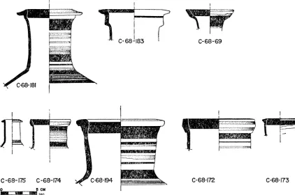
A change in the types of pottery occurred within the occupation period of phase 4; this was the result of the sudden importation of a bichrome pottery whose design is closely related to Cypriot (Fig. 8; P1. 18, a-d)."2 No pieces of this imitation Cypriot pottery were found in the fills that covered the altars of phase 3, i.e., under the floor of phase 4. All come from on and over the floor of phase 4; it constitutes about one
183 C~~~-68-;69
0-68-175 0 -68-174 C~ -68-194 --C-68-172 C-68-173
0 cm
FIG. 8. Profiles of Imitation Cyprilot Pot Necks from Cori'nth.
quarter of the decorated wares in the fill south of the retain'ing wall of phase 7. This pottery was in use, therefore, during phases 4, 5, and 6. Its i'ntroduction into mailnland Greece occurred before the openilng of the Levant by Alexander the Great, perhaps starting 'in the second quarter of the fourth century. Such a date is indicated by pots
21 I am indebted to Miss Lucy Talcott for making available to me the segment of text from
of this type from Corinth,22 and from Olynthos.23 A similar pot from a grave in Thera is dated to the fifth century.2'
Where, exactly, this pottery with varied neck profiles but rather standard painted decoration originates and why it gained a sudden popularity that then quickly died out is still unexplained. The pottery is definitely not Cypriot; 2" it may be either East Greek or from an area along the south coast of Turkey.
Pottery found in the packing against the south side of the terrace wall erected at the beginning of phase 7:
9. Imitation Cypriot bichrome amphora. P1. 18, d.
C-68-177. Max. P. Dim. 0.186m.
Clay, reddish brown with gray core, white inclusions; exterior, buff slip, surface slightly lumpy. Decoration in matt reddish brown and matt black.
Preserved upper body and sloping shoulder, stub of one horizontal body handle. Preserved motif, three vertical branches in red, black brush strokes along handle, continuing vertically down body where handle joins body. Bottommost shoulder band wide black, then wide red, reserved, thin black, reserved, thin black, reserved, wide black.
For body decoration, Daux, ibid., p. 767, fig. 7 (fifth century B.c.); D. M. Robinson, Olynthus, V, pl. XXXIII. For later example, 0. Broneer, " Excavations at Isthmia, 1959-1961," Hesperia, XXXI, 1962, pl. 11; parallel for shape and decoration from the Athenian Agora, P 6154 (Fig. 9), Athenian Agora, XII, no. 1484, pl. 63; neck of Athenian Agora P 6154 has parallel in our C-68-174, Fig. 8, both in profile and decoration.
10. Imitation Cypriot bichrome neck fragment. Fig. 8; P1. 18,a. C-68-194. Pres. H. 0.089, D. of rim 0.124 m.
Clay, reddish brown going gray at core, large white inclusions; cream slip, thin and streaky on inside, surface lumpy. Rim, neck, upper shoulder, incompletely preserved.
Decoration, matt red and matt black in horizontal bands; all outside bands black except two neck bands and top of rim; black band inside.
For similar profile, Athenian Agora P 25684 (Fig. 9), from context dated to ca. 320 to 290 B.C., Athenian Agora, XII, no. 1488, pl. 63.
22 C-53-251, fromn a well; C-37-2515, from a small cistern in the south-central agora. The
pottery is generally of the second quarter of the fourth century, C. H. Morgan, II, " Excavations at Corinth, 1936-37," A.J.A., XLI, 1937, p. 547. Also, at Isthmnia, where found with palmette lekythoi: 0. Broneer, " Excavations at Isthmia, 1959-1961," Hesperia, XXXI, 1962, pp. 16-18, 25, no. 22, pl. 11, b, left.
23 D. M. Robinson, Excavations at Olynthus, V, pp. 34-35, pl. XXXIII P 52, dated here
to a pre-Persian level.
24 G. Daux, "Chronique des fouilles et decouvertes archeologiques en Grece en 1966," B.C.H.,
XCI, 1967, p. 761, fig. 7. The body is more elongated than in the Olynthos example, shoulder more horizontal.
25 I am extremely grateful to Dr. V. Karageorghis, Director of the Departmnent of Antiquities,
EXCAVATIONS AT CORINTH 1968 59
. _
w_g __ . . __
n
_nx
r
z
X 8/
| /
s .
s i
.
w
_s
P 25684 5: - :: ! 4: -: :: 5t CM, HwB. 1968
i
X a_
X , 1
W
g I .
.. s 7 ... f _
S +v--. S r_
s w K : \ _ J A_
\
t
1 , tr$ j \\ lI wl
\
,
t?X
9'1/
D
t i1 \ 18 t 1r
i } I 0X.;. t f
\ ,. \ \a. '.,*S tV
\. *_ .S . . - _t - - = L = X
z _
\
w //
w /
/
P 6154 CM. H.B. t968
11. Black glazed skyphos, with compound body curve. P1. 18, f. C-68-193. H. 0.095, D. of base 0.053 m.
Fine, hard buff clay; good black glaze. Whole profile but no handles preserved.
Totally black glazed except reserved resting surface on foot, reserved ring and reserved center of bottom of base. Torus foot, counter-curve of body not extreme, minimum diameter immediately above foot.
D. M. Robinson, Olynthus, XIII, p. 309, no. 577, pl. 201, second quarter of fourth century B.C.
12. Attic palmette lekythos, fragmentary. P1. 18, e.
C-68-195. Pres. H. 0.057, D. of base 0.045 m.
Clay, dark tan, slightly micaceous; black glaze, reserved under base.
Ring base, maximum diameter of pot just below shoulder, slightly articulated joint between shoulder and neck, twelve-petal palmette on body, carelessly executed.
D. M. Robinson, Olynthus, XIII, pp. 150-151, pl. 104, especially no. 106. Second-third quarter of fourth century B.C.
13. Corinthian miniature banded lekythos. P1. 17, d.
C-68-192. H. 0.074, D. at rim 0.027, Max. D. of body 0.027 m.
Clay, light orange buff; four horizontal bands and lip in red. Complete profile.
Typical Corinthian shape with rounded body, slightly slimmer than examples of North Cemetery.
Second, C-68-191, slightly smaller (H. 0.064 m.) and buff clay, three body bands, found in same fill (P1. 17, c).
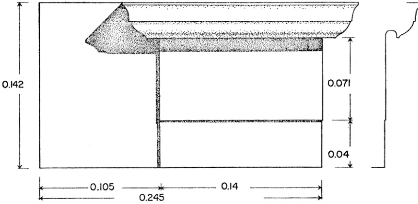
Phase 7 has, as its major alteration, the re-erection of an early triglyph wall into the position over the reservoir of the fountain house where it is still preserved in situ. The erection of the triglyph wall over the reservoir has been assigned to an alteration of the spring in the first half of the fourth century B.C.2" It should, how-
ever, be dated to the last of the fourth or to the early third century B.C. The pottery from the fill against the south side of the terrace wall that was built in phase 7 is of the second to the last quarters of the fourth century and had a period of use before it was used as wall fill. Also, there is built into an upper course of the foundations of the triglyph wall, at 3.50 m. north of its southeast corner, a small anta block which still preserved a hawksbeak and cavetto crowning moulding (Fig. 10). The hawksbeak profile is a gentle cyma reversa moulding; this suggests that the block cannot have been carved before the second half of the fourth century; thereafter it was re-used as a foundation block in the triglyph wall. The mouldings of the anta capital are extremely similar to those of a low pier that was probably used on the second floor of the South Stoa of Corinth.2
The abandonment of the temenos of the Sacred Spring comes with the end of phase 8. The continuation of wheel ruts that are visible in the stone monument bases parallel to and immediately east of the south end of the triglyph wall of the Spring was found in the earth floors of phase 8 at the northeast of the ruts in the bases. The roadway was apparently made during the period of abandonment of Corinth, 146-44 B.C.
26 Hill, pp. 174-177, esp. p. 185.
EXCAVATIONS AT CORINTH, 1968 61
Within the road ruts were found long-petal Megarian bowl fragments and f rag- ments of Argos black stone with finished faces that come from bases in the area that supported statues,28 apparently broken up during the sack of Corinth by the Romans. The finds of especial interest, but for reasons other than chronology, are the lekythoi, by far the commonest type of pottery found throughout the levels of the Sacred Spring. The lowest strata produced some late black-figured lekythoi. In the late fifth century, there are examples of Corinthian white-ground lekythoi as well as
0.142 0.071
0.04
0.105~ ~~~ IT, ~ ~~} 0.1C~4S **j,!yqw;
FGL SOTlR SEGMENTT OFTEl~HWL
0.142 1 ~~~0.245i
SIDE FACE OF ANTA CAPITAL BUILT INTO THE FOUNDATION OF THIE
SOUTFIERN SEGMIENT OF THQE TRIGLYPH WALL
FIG. 10. Elevation and Profile of an Anta Capital built into Foundations of Triglyph Wall. Scale 1:2. stamped, red-figured, and net-patterned. TI the fourth and possibly into the early third century the commonest are the miniature banded Corinthian 29 (13) and the
Attic palmette lekythoi (12). In the latest levels the lekythos is displaced by the Hellenistic unguentarium.
Votives other than lekythoi are rare. Very few terracotta figurines were found if compared with the quantities found in other cult spots of Ancient Corinth. The types were limited to horse and riders, animals, and two handmade temple boys. Numerous bronze earrings with pendant decoration in pyramidal form were found in various post-altar fills.
28 Lysippos base, Corinth, VIII, i, no. 34; nos. 38-42, other bases of this stone found through-
out the excavation area of the agora.
29 These were not necessarily limited to use as grave offerings but may have been used, also,
14. Terracotta figurine, temple boy. P1. 18, g. MF-68-55. Pres. H. 0.053 m.
Clay tan, traces of yellow paint. Missing its right foot, both arms, head.
Seated boy with legs doubled in front of him, his right leg overlapping left foot. Second, more fragmentary figurine, MF-68-62, found against latest mud altar of phase 3.
15. Terracotta mouldmade male head. P1. 15, a.
MF-68-61. Pres. L. 0.119m.
Clay tan, matt red for skin, white for helmet and eyes.
Heavy features, slightly askew, probably warped when figurine was withdrawn from mould. Helmet (?) with visor up, hair falling to shoulders from under helmet. Crease in brow.
16. Bronze earring pendant. P1. 18, h.
MF-68-127. H. 0.0105, W. 0.0055 m. Bronze, missing wire ear loop.
Four-sided pyramidal form with pomegranate at apex. Body of pyramid grooved, attached to two-stepped base, wire ear loop soldered to step plate.
Variations of this form found: MF-68-102, MF-68-104, MF-68-106, MF-68-121, MF-68-123, MF-68-125, MF-68-126; bronze loop earring with lion's head, MF-68-107.
No inscriptions, dipinti, or graffiti were found that help with the identification of the cult that apparently reserved the area around the Sacred Spring from the earliest classical period until the fall of Corinth in 146 B.c.
Excavation will continue in this area next spring.
BATH NORTH OF THE PERIBOLOS OF APOLLO
Two years of work have revealed a bath of early Roman plan, extensively rebuilt, apparently in the second century after Christ. The eastern and northern limits of the structure extend into undug areas. The plan of the early building is clear, how- ever, in the following points. There is a porticoed entrance protruding from the east colonnade of the Lechaion Road, by which entry to the bath was gained. Elvidence for this portico is seen in the angles made by the gutter of the colonnade as it passed around the portico and by the pediment block (17) that once formed part of the entrance faqade.
17. Central block of pediment wall, with medallion. P1. 18, i.
A 770. H. 0.958, W. 1.303, Th. 0.24 m.
Bluish, fine grained marble. Two pieces preserving complete block.
Central block of probable five that once formed triangular tympanum 5.80 m. long. Back of block roughly picked, top and bottom surfaces finely pick dressed, sides with anathyrosis. Front face has medallion centered, 0.052 m. above bottom edge of block, tangent to top edges. Maximum diameter of medallion frame, 0.88 m. Frame has mouilding in two degrees. Outer is disk 0.072 m. wide with ovolo inside, projecting 0.092 m. from pediment wall face. No trace remains of bust originally within medallion; chiseled away leaving hole in block. Thereafter a bronze medallion apparently was applied over marble medallion frame. Metal medallion attached to pediment wall by four rectangular dowels, ca. 0.03 by 0.03 m.
EXCAVATIONS AT CORINTH, 1968 63
One went through the columned entrance to the bath and between two shops of the row that, like the bath, opened onto the Lechaion Road. Once behind the shops, which were 6.70m. deep, one was in a colonnaded portico that ran along the back (east) wall of the shops and that formed the west side of an open court. This north-south colonnade was 3.90 m. wide, with stone stylobate and gutter. In the repair of the bath the court was paved in herringbone pattern by terracotta tiles and the gutter was covered by the same paving.
The walls of the bath in its first period were of well cut rectangular poros blocks, generally between 0.58 and 0.60 m. thick. The plan as indicated by the poros walls is that of a series of rectangular rooms along the west and north sides of an open court. In this period there was a rectangular plunge 8.35 m. north-south by 4.68 m. east-west on the east-west axis of the court. It was about 1.25 m. deep. The plunge was tiled in diamond-shaped terracotta tiles, laid in star pattern.
In the second period the bath was radically reorganized. A larger, not quite rectangular plunge, 4.52 m. by 6.60 mi., was built at the southwest corner of the building to replace the smaller plunge in the court. A hypocaust was constructed near the center of the range of rooms along the east side of the paved court. This heated a room that was ca. 5.70 m. in its north-south dimension, but which still has its east wall hidden under unexcavated fill. The poros walls of the room in its original phase were lined with brick for the new use; the floor of the hypocaust was paved with large tiles, and rectangular hypocaust columns were constructed to support the floor above, which is now completely destroyed.
The complex appears to have come to an end as a bath either as a result of the earthquake of A.D. 365 or 375 or by enemy action under Alaric in A.D. 395.8? There- after the area was reoccupied by Corinthians who turned it into an industrial establish- ment, apparently concerned with the making of glass, and a probable residence or residences.
CHARLES K. WILLIAMS, II AMERICAN SCHOOL OF CLASSICAL STUDIES
ANCIENT CORINTH
THE TERRACE OF -PARAPET WALL
THE APSIDAL BUILDING - WALL
LOWER TEME NOS AREA
TNEL FOR WATER COLLECTION
R E E R V CI R
DRAW CHANNEL A
BASIN WATER CHANNEL 8
I I I I~~~~ METERS
0 , I i |^sN\R
SCHEMATIC EAST-WEST SECTION THROUGH FOUNTAIN HOUSE
a. Schematic Section through Fountain House, Phase I, looking North
-x I
b. Paving of Fountain House Facade, Reservoir, and Later Triglyph Wall above, from Northeast. Tympanum Block upright on Destroyed Floor of Reservoir
Sacred Spring
PLATE 13
a. Epistyle Block to be associated with Apsidal Temple
A'88t 't; .L M.1 - .U- r f
bO.. Terae als o Pass an 8Stat beow ad op ltr lor, ro Nrt
ScdSi
CHARLES K. WILLIAMS II: EXCAVATIONS AT CORINTH, 1968
t____~~~~R -
. .~~~~~~~~~~~~A _ . ,
b. Terrace Walls of Phases 7 and 8, Strata below, and Top Altar Floor, from North Sacred Spring
a. Phase 3, Mid-section of Altar with part of Phase 7 Wall removed, from North-northeast
... a.
PLATE 15
b. Fragment of Marble Screen, probably from Cap- tives Faade
a. Terracotta Male Head, MF-68-61 (1 :1)
A4~~~~~~~~~~~~~4
,. j' N4 .W
s~~ ~c ardSrn.Pae4 Poros Cubin.ihHls FrogmWestofabecenpoalfoCp
a. Sacred Spring. Phase 5, Trenches of Third Structure, from North-northeast. 2. Floor of Phase 5; 3. Floor of Phase 4
-E:- -- I' -- '
a. ScredSprig.hase5,Te Greeko Buildin Stylobate; 4.o Dorai-norWhall. of Greek Building5
PLATE 17
a. Northwest Stoa. Wheelruts along South Fasade of Stoa, from East
b. Corinthian Red-figured Stemless Cup C-68-1 13 e. Corinthian Red-figured Stemless Cup C-68-1 14
(2:3) (2:3)
c., d. Corinthian Le- kythoi C-68-
191,192 (1:2)
a. C-68-194 and C-68-181 (2:5)
b. C-68-69 (1:2)
c. C-68-170 C-68-184
C-68-185 C-68-171
(2:5)
d. C-68-177 (1:2)
a.-f. Imitation Cypriot Pottery and Contemporary Material
e. C-68-195 (1:2)
f. C-68-193 (1:2)
c.~ ~ ~~ Bronze7 ~h Earrng-Pndan
, C-68-1M7768-17((1:1 J d.
_ y _ a.-f~~~~~~~~~~~~~. Bmiathi o Cyrof rt Poteriblo ofd Aotepollo aera
g.
Seated Temple Bo 9 F6- 11