www.nat-hazards-earth-syst-sci.net/15/2413/2015/ doi:10.5194/nhess-15-2413-2015
© Author(s) 2015. CC Attribution 3.0 License.
Quantitative comparison between two different methodologies
to define rainfall thresholds for landslide forecasting
D. Lagomarsino, S. Segoni, A. Rosi, G. Rossi, A. Battistini, F. Catani, and N. Casagli Earth Science Department, University of Firenze, Firenze, Italy
Correspondence to: S. Segoni ([email protected])
Received: 6 January 2015 – Published in Nat. Hazards Earth Syst. Sci. Discuss.: 30 January 2015 Revised: 16 July 2015 – Accepted: 18 October 2015 – Published: 23 October 2015
Abstract. This work proposes a methodology to compare the forecasting effectiveness of different rainfall threshold models for landslide forecasting. We tested our methodol-ogy with two state-of-the-art models, one using intensity– duration thresholds and the other based on cumulative rain-fall thresholds.
The first model identifies rainfall intensity–duration thresholds by means of a software program called MaCumBA (MAssive CUMulative Brisk Analyzer) (Segoni et al., 2014a) that analyzes rain gauge records, extracts inten-sity (I) and duration (D) of the rainstorms associated with the initiation of landslides, plots these values on a diagram and identifies the thresholds that define the lower bounds of theI–Dvalues. A back analysis using data from past events is used to identify the threshold conditions associated with the least number of false alarms.
The second model (SIGMA) (Sistema Integrato Gestione Monitoraggio Allerta) (Martelloni et al., 2012) is based on the hypothesis that anomalous or extreme values of accu-mulated rainfall are responsible for landslide triggering: the statistical distribution of the rainfall series is analyzed, and multiples of the standard deviation (σ) are used as thresholds to discriminate between ordinary and extraordinary rainfall events. The name of the model, SIGMA, reflects the central role of the standard deviations.
To perform a quantitative and objective comparison, these two models were applied in two different areas, each time performing a site-specific calibration against available rain-fall and landslide data. For each application, a validation procedure was carried out on an independent data set and a confusion matrix was built. The results of the confusion matrixes were combined to define a series of indexes com-monly used to evaluate model performances in natural
haz-ard assessment. The comparison of these indexes allowed to identify the most effective model in each case study and, con-sequently, which threshold should be used in the local early warning system in order to obtain the best possible risk man-agement.
In our application, none of the two models prevailed ab-solutely over the other, since each model performed better in a test site and worse in the other one, depending on the characteristics of the area.
We conclude that, even if state-of-the-art threshold models can be exported from a test site to another, their employment in local early warning systems should be carefully evaluated: the effectiveness of a threshold model depends on the test site characteristics (including the quality and quantity of the in-put data), and a validation procedure and a comparison with alternative models should be performed before its implemen-tation in operational early warning systems.
1 Introduction
One of the most common methodologies for the forecasting of landslide occurrence is the definition of rainfall thresholds. A rainfall threshold is an equation (based on two or more rainfall parameters) that discriminates between the rainfall conditions for which one or more landslides would or would not be triggered.
thresh-olds based on intensity and duration are probably the most common (Caine (1980), Guzzetti et al. (2008) and references therein); another very used threshold typology makes use of rainfall amount accumulated over given time periods (Wil-son, 2000; Chleborad, 2003; Cardinali et al., 2006; Cannon et al., 2008, 2011) or variable time windows (Lagomarsino et al., 2013).
Independently from the rainfall parameters used to char-acterize the triggering conditions, every study that made use of both rainfall events that triggered and that did not trig-gered landslides highlighted that it is impossible to perfectly divide the diagram into a 100 % landslide field and a 100 % non-landslide field (Berti et al., 2012; Staley et al., 2013). This brings the necessity of taking a fundamental conceptual decision when defining a threshold: a conservative threshold that would encompass all future landslides should be defined or the best trade-off between identified landslides and missed alarms should be researched? It does not exist a universally valid response, as the right answer depends on the objective of the threshold. Indeed, it is important to highlight that in the existing literature, some thresholds have been used to identify the minimum rainfall conditions possibly leading to landsliding, while others have been specifically designed to be operated in warning systems for civil protection purposes. The first kind of threshold (minimum thresholds hence-forth) is commonly defined as the lower bound to a data set of rainfall conditions that in the past were associated to land-slide triggering (Caine, 1980; Larsen and Simon, 1993; Can-non et al., 2008; Brunetti et al., 2010; Berti et al., 2012): it is expected that any future landslide will fall above the thresh-olds. Since minimum thresholds are very conservative, a high number of false alarms is usually expected, because the lower the threshold, the lower the possibility of missing a landslide and the higher the possibility of committing false alarms.
The second kind of thresholds (early warning thresholds henceforth) usually aims to obtain the best possible compro-mise between effectiveness in recognizing triggering condi-tions (for which a low threshold would be preferable) and effectiveness in committing a low number of false alarms (for which a high threshold would be preferable) (Martel-loni et al., 2012; Staley et al., 2013; Segoni et al., 2014a, 2015a). In other words, the task of a warning system is to avoid both missed alarms and false alarms as much as possi-ble. Both kinds of errors are considered dangerous, as missed alarms may expose society to unrecognized hazards, while false alarms, especially when recurring, may lead to a mis-perception of risk and to a distrust in the warning system itself (Staley et al., 2013).
The errors committed by a threshold can be recognized and evaluated only after a validation procedure is carried out, but despite rainfall thresholds for the occurrence of land-slides being a long-debated research topic, only a small num-ber of works completes the presentation of a new threshold with a quantitative validation of its performances (Martelloni et al., 2012; Staley et al., 2013; Lagomarsino et al., 2013;
Segoni et al., 2014a, b; Gariano et al., 2015) or with a com-parison with an independent data set of landslide and rainfall data (Giannecchini et al., 2012). This leads to an additional limitation when a comparison between different thresholds is needed. In fact, while many studies on rainfall thresholds contain a comparison between different literature thresholds (Guzzetti et al., 2007, 2008; Rosi et al., 2012; Chen and Wang, 2014), in most cases this is just a visual compari-son of the threshold equations. This comparicompari-son is interest-ing from many scientific points of view (e.g., the influence of meteorological regime, landslide typology or other physical features on the threshold equations), but thresholds are very site-specific (Segoni et al., 2014b) and when a comparison is needed to decide which threshold should be used in a warn-ing system, it is of limited usefulness to compare a threshold obtained using a given methodology in a test site with the threshold obtained using a different methodology in another test site. Moreover, a comparison would be more useful if it were based on quantitative indexes describing the perfor-mances of the thresholds.
This paper explores the aforementioned issues and pro-poses a quantitative approach for comparing different methodologies for rainfall threshold definition, in order to assess which of them is the most effective for operational use in civil protection warning systems.
Two state-of-the-art models based on rainfall thresholds, namely SIGMA (Martelloni et al., 2012; Lagomarsino et al., 2013) and MaCumBA (Segoni et al., 2014a, b), are taken into account and are applied in two test sites. In each test site, each model undergoes a site-specific calibration to op-timize its performance. A validation procedure is carried out on an independent data set and a confusion matrix is built. The results of the four confusion matrixes (true positives, true negatives, false positives and false negatives) are com-bined to define some indexes commonly used to evaluate model performances in hazard assessment (Begueria, 2005) and in rainfall thresholds (Martelloni et al., 2012; Gariano et al., 2015; Rosi et al., 2015). The comparison of these indexes assessed which model provides the best performance in each case study and, consequently, which threshold should be used in the local early warning system in order to obtain the best possible risk management.
2 Material and methods 2.1 SIGMA
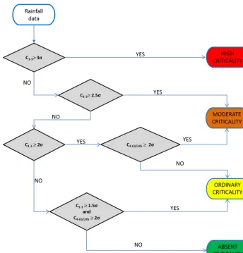
differ-Figure 1. SIGMA algorithm (modified after Martelloni et al., 2012).C1−3stands for the cumulate rainfall of the last 1, 2 or 3 days.C4−63/245 stands for the rainfall values cumulated in the last 4 days, last 5 days and so on, up to the last 63 days during the dry season or 245 days during the wet season.
ent periods of accumulation: from 24 h up to 245 days, with daily step (Martelloni et al., 2012). These analyses allow the recognition of anomalous rain values, quantifying the value of the standard deviation of the distribution for each accumu-lation period. Considering different multiples of standard de-viation, different thresholds are then defined (σ curves). An optimization algorithm compares theσcurves with the land-slides contained in a calibration data set and identifies theσ
curves that minimize the occurrence of false alarms (Martel-loni et al., 2012). The selectedσ curves are implemented in a warning system (named SIGMA, as the model) in which the measured and the forecasted rainfall is compared with these thresholds, according to the algorithm depicted in Fig. 1, to define the daily criticality level.
The entire territory of Emilia Romagna is subdivided into eight alert zones (AZ). For each of these, different rain gauges are selected, for a total of 25. Each rain gauge is representative of an area called the territorial unit (TU). The alerts calculated for each TU belonging to the same AZ are
then combined to give a single alert for each AZ (Lago-marsino et al., 2013).
The Emilia Romagna regional early warning system is completed by a module that accounts for the effects of snowmelt and snow accumulation (Martelloni et al., 2012) and by a combination with purposely developed landslide susceptibility zonation that improves the spatial accuracy of the SIGMA model (Segoni et al., 2015b). However, these ad-ditional features are not considered in this work.
2.2 MaCumBA
MaCumBA is the model used to define the thresholds for the Tuscany regional landslide early warning system, which is based on intensity–duration thresholds expressed in the form (Caine, 1980):
I=αDβ,
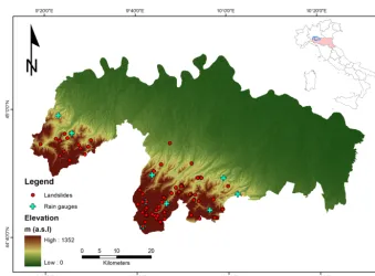
parame-Figure 2. The test site in the Emilia Romagna region, with the location of rain gauges and landslides used in this study.
ters. One of the peculiarities of the MaCumBA model is that thresholds are characterized by a third parameter, called “no rain gap” (NRG). NRG is the number of consecutive hours without rain necessary to separate two rainfall events (Segoni et al., 2014a); this parameter is of fundamental importance to ensure the replicability of the analysis and to consistently employ the thresholds into an operational early warning sys-tem (Segoni et al., 2015a).
The procedure for parameters calculation is automated (Segoni et al., 2014a) and allows a large amount of data to be processed: starting from a landslide and a rainfall database, a software program analyzes each cumulated rainfall recorded in the vicinity of a landslide and the most critical rainfall con-ditions are identified and characterized in terms ofI andD. Once theI andDparameters of every landslide are calcu-lated, they are plotted in aI–Ddiagram and the lower bound threshold is automatically identified. The procedure is com-pleted by a back analysis that identifies the NRG value that minimizes the occurrence of errors during a calibration pe-riod.
The model MaCumBA is explained in detail in Segoni et al. (2014a), while Segoni et al. (2014b) discusses its appli-cation to Tuscany, which was subdivided into 25 alert zones, each of them characterized by a specific threshold. Segoni et al. (2015a) described the integration of the thresholds into the Tuscany regional warning system, which compares the mo-saic of thresholds defined by MaCumBA with rainfall fore-casts and rainfall measurements from an automated network composed of about 300 rain gauges.
2.3 Similitudes and differences between SIGMA and MaCumBA
Both methods are presently used by regional civil protection agencies for landslide early warning systems at regional scale (over 20 000 km2). SIGMA and MaCumBA operate in the Italian regions of Emilia Romagna and Tuscany, respectively. They provide automatic outputs, based on the comparison of rainfall thresholds with rainfall forecasts and real-time mea-surements from automated rain gauge networks. Both early warning systems are based on a mosaic of local-scale thresh-olds: the region is subdivided into smaller areas that are char-acterized by a site-specific threshold and that are monitored independently. This approach allows landslides of mixed ty-pology to be accounted for and increases the spatial accuracy. The main difference between the models lies in the cal-culation of the thresholds and in the input data required. While SIGMA thresholds are based on cumulative rain-fall and consider variable time spans ranging from 1 to 245 days, MaCumBA is based on intensity–duration thresh-olds. SIGMA requires long rainfall recordings (50–60 years time series) but, on its basic implementation, thresholds can be defined even without landslide data. In turn, MaCumBA needs a complete landslide database to evaluate intensity– duration thresholds, but a shorter period of rainfall data (5– 10 years) is required.
To quantitatively compare these two models, we applied MaCumBA in an Emilia Romagna alert zone (Fig. 2) and SIGMA in a Tuscany alert zone (Fig. 4).
land-slide data sets present peculiar characteristics, which will be described in the next sections. For instance, the landslide data set in Tuscany extends from 2000 to 2009, while in Emilia Romagna from 2004 to 2010. However, a straight comparison between the models is guaranteed by adopting identical decisions during the validation and calibration of both models within the same test site. The application in Emilia Romagna follows the characteristics of Lagomarsino et al. (2013), while application in Tuscany is coherent with Segoni et al. (2014a, b). As a consequence, in Emilia Ro-magna, the data set was split into two independent subsets: 2004–2007 for calibration, and 2008–2010 for validation. In Tuscany, the data set from 2000 to 2007 is used for the cali-bration, and the data set from January 2008 to January 2009 is used for the validation.
3 Application to the Emilia Romagna test site
The region of Emilia Romagna (northern Italy) is dominated in the south by the Apennines. The hilly and mountainous sector extends from the Apennine ridge, in the SW of the region, to the Pede-Apennine margin, in the NE. The chosen alert zone, denoted H, lies in the northwestern part of the region (Fig. 2), and consists of a hilly and mountainous zone, with a maximum elevation of about 1300 m.
The application of SIGMA in the test site is already pub-lished (Martelloni et al., 2012; Lagomarsino et al., 2013) and considered the time span 2004–2007 as the calibration pe-riod, and the time span 2008–2010 as the validation period. The calibration data set consists of data of 71 landslides, trig-gered during 17 distinct rainfall events, while for the valida-tion, the data of 39 landslides triggered during 18 rainfall events were available (Fig. 2).
Flysch is the lithology most frequently associated to land-slides (about 70 %), while 26 % occurred on hillslopes made up of soft or incoherent rocks (pelagic limestone, claystone and chaotic complex), which are usually covered with cohe-sive terrains.
The landslide database does not include complete infor-mation on the landslide typology, as in most cases (54 %) it is not specified. A total of 11 and 15 % of the occur-rences can be comprehended in the “shallow landslide” and “deep-seated” category, respectively, while for 19 % of the landslides, flow is the prevailing mechanism. This informa-tion seems to be in accordance with the landslide character-istics commonly reported by the existing literature, which states that the most frequent phenomena are deep-seated landslides (mainly rotational–translational slides, slow earth flows and complex movements) (Bertolini and Pellegrini, 2001; Bianchi and Catani, 2002; Trigila et al., 2010) and that rapid shallow landslides, although less recurrent, have increased their frequency in the last few years (Martina et al., 2010; Montrasio et al., 2011).
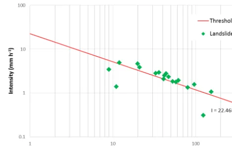
Figure 3. Intensity–duration threshold calculated by MaCumBA for the Emilia Romagna test site. Since some of the landslides occurred on the same day and at nearby locations, a singleI–Dpoint in the graph can be representative of more than one landslide.
While the SIGMA model makes use of only two reference rain gauges (one for the western sector and one for the east-ern sector of the alert zone), to apply MaCumBA at its full potential, all nine automated rain gauges installed in the alert zone were used (Fig. 2). For all of them, we extracted hourly rainfall measurements pertaining to the calibration and val-idation period and we applied the procedure described in Segoni et al. (2014a) and summarized in Sect. 2.2.
The application of MaCumBA to this case study resulted in a threshold represented by the equation:
I=22.46D−0.64.
This threshold is reported in Fig. 3, where the events used for its calibration are also represented. Since some of the land-slides occurred on the same day and at nearby locations, a singleI–Dpoint in the graph can be representative of more than one landslide. In particular, the three points below the thresholds are each representative of a single landslide. Con-sequently, the threshold encompasses 68 out of 71 landslides of the calibration data set, which is within the 95 % confi-dence level selected for the threshold analysis (as in Segoni et al., 2014a).
4 Application to the Tuscany test site
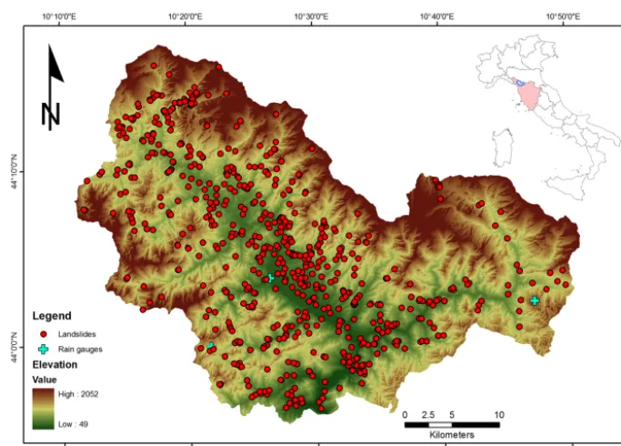
Figure 4. The test site in the Tuscany region, with the location of rain gauges and landslides used in this study.
the slopes, composed of metamorphic sandstone and phyl-litic schist and covered by talus and scree deposits. The east-ern sector shows a more uniform geological condition with the prevalence of flysch rocks.
The application of MaCumBA in Tuscany and in the Ser-chio alert zone is already published (Segoni et al., 2014a, b) and considered the time span 2000–2007 as the calibration period and the time span from 1 January 2008 to 31 Jan-uary 2009 as the validation period. The calibration data set counts 719 landslides, related to 79 distinct rainfall events, while the validation data set counts 272 landslides, related to seven distinct rainfall events (Segoni et al., 2014a, b). Among these, debris flows and shallow landslides are the largely pre-vailing typologies (89 % of the landslides with known ty-pology). The lithologies most affected by landslides are fly-sch (60 % of the occurrences), limestone and marble (22 %), clayey rocks (8 %) and granular terrain (7 %).
Using the calibration data set, the SIGMA model has been applied to the Serchio AZ (Fig. 4). Concerning rainfall data, the 37 automated rain gauges used for MaCumBA were an-alyzed; however, most of these instruments were installed in recent times, and only three of them have the characteristics (time series between 60 and 70 years) to be used for the sta-tistical analyses needed in SIGMA (Fig. 4). One of the three rain gauges is located in the center of the alert zone, while the other two are close to the eastern and southwestern borders (Fig. 4).
As demonstrated by Lagomarsino et al. (2013), it is not straightforward to decide how many and which rain gauges have to be used in SIGMA to obtain the best possible land-slide prediction. According to Lagomarsino et al., (2013), the
application of SIGMA comprehended some tests to identify the optimal configuration of the model. We tested all possi-ble configurations: the alert zone subdivided into three ter-ritorial units, each with one of the three instruments as the reference rain gauge; three different configurations in which the alert zone was not partitioned and the three rain gauges were selected each time as the only reference rain gauge for the whole of the alert zone and three possible combinations using two rain gauges as reference for an alert zone split into two distinct territorial units. We verified that the best outcomes were obtained using the central rain gauge as the unique reference rain gauge for the entire alert zone. This result is only partially surprising, as when Lagomarsino et al. (2013) tuned SIGMA to optimize the results, an identical circumstance was found in one of the eight Emilia Romagna alert zones.
Using the calibration procedure reported in Martelloni et al. (2012) and summarized in Sect. 2.1, the thresholds shown in Fig. 5 were selected as the optimal ones for the Serchio alert zone.
5 Results
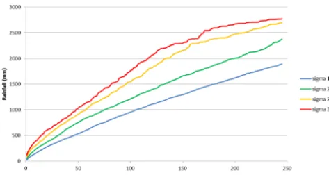
Figure 5. Rainfall thresholds obtained with the SIGMA model in the Serchio AZ; please note that the thresholds are defined for a maximum accumulation period of 245 days, since longer periods of accumulation are not used in the decisional algorithm of the model (Fig. 1).
rainfall data from the validation data set. The simulated daily outputs of each model were compared to the landslides which occurred during the validation period, so as to count
– true positives (TP), which are days with landslides cor-rectly detected by the model (the model raised an alarm and it was verified that a landslide occurred);
– true negatives (TN), which are days without landslides in which the model did not raise an alarm;
– false positives (FP), which are days in which the model raised an alarm but no landslides occurred (false alarms or “errors of commission”);
– false negatives (FN), which are days in which at least one landslide occurred, but the model did not raise an alarm (missed alarms or “errors of omission”).
In each case study, these occurrences were combined to de-fine some indexes commonly used to evaluate model perfor-mances in hazard assessment (Begueria, 2005) and in rainfall thresholds (Martelloni et al., 2012). The following indexes quantify the forecasting effectiveness of the models in the different test sites and allow for a rigorous comparison of the performances.
– Positive predictive power (PPP) is the propor-tion of positive results that are true positives: PPP=(TP)/(FP+T P).
– Negative predictive power (NPP) is the propor-tion of negative results that are true negatives: NPP=(TN)/(FN+TN).
– Sensitivity (Se, also called the true positive rate) measures the proportion of positive occurrences (landslides) which are correctly identified as such: Se=TP/(TP+FN).
Table 1. Contingency matrix displaying the results of the validation of MaCumBA in the Emilia Romagna test site. In this test site, the validation data set spans from 2004 to 2007. TP denotes true posi-tives, FP false positive errors, FN false negative errors and TN true negatives.
Emilia Romagna Observed truth
test site
MaCumBA model Landslide No landslide
Prediction
Landslide 6 (TP) 7 (FP) No
12 (FN) 1071 (TN) landslide
– Specificity (Sp, also called the true negative rate) mea-sures the proportion of negative occurrences (days with-out landslides) which are correctly identified as such: Sp=TN/(TN+FP).
– Likelihood ratio (LR) evaluates both the sensitivity and the specificity of a model in a single parameter: LR=Se/(1−Sp)=[TP/(TP+FN)]/[1−TN/(TN+FP)]. – Efficiency (Ef) is an index that evaluates the
over-all performance of a model, measuring the propor-tion of correct predicpropor-tions with respect to the total: Ef=(TP+TN)/(FP+FN+TP+TN).
A perfect predictor would be 100 % sensitive and 100 % spe-cific and would have a PPP and NPP equal to 1. In a warning system, the best possible trade-off between sensitivity and specificity is usually researched. Two indexes that help to evaluate this trade-off and thus the overall performance of the model are the efficiency and likelihood ratios. However, when used in circumstances where TN are 1 or 2 orders of magnitude higher than all other occurrences, as in landslide early warning systems, efficiency values can be very close to 1 (optimal value): this strongly reduces the weight of TN occurrences in assessing the final value and prevents a proper comparison between efficiency values, which are very close to each other. This drawback does not affect the likelihood ra-tio, which evaluates both the sensitivity and the specificity in a single parameter: the higher its value, the better the model. For the Emilia Romagna test site, the validation results are summarized in contingency matrixes (Tables 1 and 2) and can be quantitatively compared in Table 3.
For the Tuscany test site, the validation results are summa-rized in Tables 4 and 5 and can be quantitatively compared in Table 6.
6 Discussion
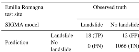
Table 2. Contingency matrix displaying the results of the valida-tion of SIGMA in the Emilia Romagna test site. In this test site, the validation data set spans from 2004 to 2007. TP denotes true posi-tives, FP false positive errors, FN false negative errors and TN true negatives.
Emilia Romagna Observed truth
test site
SIGMA model Landslide No landslide
Prediction
Landslide 18 (TP) 12 (FP) No
0 (FN) 1066 (TN) landslide
was performed separately for each test site, to assess which model would perform better in a landslide warning system.
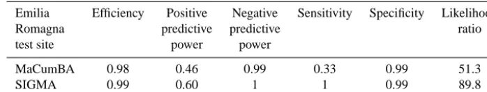
In the Emilia Romagna test site, MaCumBA identified only six out of 18 landslide events, while SIGMA correctly identified all of them (Tables 1 and 2). However, SIGMA committed a higher number of false positives (12 against seven committed by MaCumBA). Looking at validation statistics (Table 3), it can be seen that SIGMA indexes are higher than MaCumBA ones, especially in the case of the positive predictive power and sensitivity. Considering both efficiency (that balances positive and negative predictive power) and likelihood ratio (that balances sensitivity and specificity), SIGMA performs better than MaCumBA (Ta-ble 3).
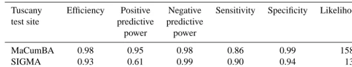
In the Tuscany test site, MaCumBA and SIGMA identified a similar number of landslide events (18 and 19 out of 21, re-spectively), while a relevant difference exists in the number of false alarms: 12 for SIGMA and only one for MaCumBA (Tables 4 and 5). Consequently, MaCumBA has higher posi-tive predicposi-tive power and specificity, but lower negaposi-tive pre-dictive power and sensitivity than SIGMA (Table 6). To as-sess which model has the best overall performance, we com-pared efficiency and likelihood ratio: both indexes are higher for MaCumBA (0.98 against 0.93, and 158.6 against 13.9, respectively).
This comparison revealed that none of the two models can be considered better than the other: SIGMA performed bet-ter than MaCumBA in the Emilia Romagna test site, while MaCumBA prevailed in the Tuscan test site. Indeed, the per-formances of a model can vary substantially from one ap-plication to another. It is evident that in each test site, the best results were obtained with the model specifically con-ceived for the characteristics of the case study. Among these characteristics, the different landslide typologies could be put in relation with the performance of the models: MaCumBA, which is based on intensity–duration thresholds, prevails in the Serchio Valley that is affected mainly by shallow land-slides; SIGMA is based on a more complex decisional algo-rithm conceived to account for both shallow and deep-seated
landslides, and it prevails in the Emilia Romagna test site, which is affected by both typologies of landslides.
Another feature that can greatly influence the performance of a model from one application to another is the quantity and quality of the rainfall data available. For instance, it is well established (Staley et al., 2013; Vessia et al., 2014) that theI–Dthreshold provides the best results when rain-fall is measured at hourly or even smaller time steps, while the SIGMA model is specifically conceived to be applied on rainfall data with a daily time step. However, in this work, rain gauges provide hourly rainfall data, and the larger flex-ibility of SIGMA is not fully exploited. A feature that could have had a relevant impact in the results is the spatial den-sity of the rainfall measurements. In the Emilia Romagna test site, fewer rain gauges are available, but they all have long rainfall series. This is an optimal condition to apply SIGMA, which needs only a limited number of rain gauges, since each territorial unit is analyzed and monitored by a single reference rain gauge. Conversely, this condition is a strong limitation for the employment of an I–D threshold model like MaCumBA: the very longer time series do not provide an additional value, and the lower number of points of measurements constrains the accurate characterization of the landslides in terms of intensity and duration of the trig-gering rainfall. The Tuscany test site has opposite conditions: the rain gauge network is very dense, but only very few in-struments (namely, three) have long enough time series to implement SIGMA. Taking into consideration the three rain gauges that could serve as reference, the calibration proce-dure of SIGMA allows the best possible model configura-tion to be defined, but it is the best opconfigura-tion among a few options available. Moreover, the calibration results (a single rain gauge used as a reference for the whole of the area) highlight that large sectors of the area could not be fully represented by the rain gauges available. On the contrary, MaCumBA can be successfully applied in these conditions, as the short time series are not a handicap (provided they cover the same time period of the landslide inventory) and the high network density allows the triggering rainfall inten-sity to be identified with sufficient approximation.
Table 3. Validation statistics and comparison of the performances of the two models in the Emilia Romagna test site.
Emilia Efficiency Positive Negative Sensitivity Specificity Likelihood
Romagna predictive predictive ratio
test site power power
MaCumBA 0.98 0.46 0.99 0.33 0.99 51.3
SIGMA 0.99 0.60 1 1 0.99 89.8
Table 4. Contingency matrix displaying the results of the valida-tion of SIGMA in the Tuscany test site. In the Tuscany test site, the validation data set spans from 1 January 2008 to 31 January 2009. TP denotes true positives, FP false positive errors, FN false negative errors and TN true negatives.
Tuscany Observed truth
test site
MaCumBA model Landslide No landslide
Prediction
Landslide 18 (TP) 1 (FP) No
3 (FN) 184 (TN) landslide
is usually desirable and the weights could be assigned with a political decision. The impact of the countermeasures to be taken in response to alarms may lead to different levels of ac-ceptance of false alarms, which in turn could lead to different weights.
7 Conclusions
Rainfall thresholds are widely used in landslide forecasting and they often constitute the core of civil protection warn-ing systems. However, most of the rainfall thresholds pre-sented in the literature were not subject to a rigorous vali-dation procedure. Moreover, no publication exists that quan-titatively compares two or more different rainfall threshold models with the aim of choosing the one with the best fore-casting effectiveness.
This paper proposes a methodology to compare different rainfall threshold models and to assess which of them would constitute the most effective warning system.
The proposed methodology goes beyond the commonly adopted visual comparison of literature thresholds and con-sists of the application of the models to a common case study to define site-specific thresholds, performing a calibra-tion and a validacalibra-tion procedure against independent data sets, building a confusion matrix and using it to derive a series of statistical indexes. These indexes can be considered as indi-cators of the performance of the thresholds and can provide an objective basis for the quantitative comparison of the ef-fectiveness of the threshold models. We propose, in partic-ular, taking the likelihood ratio and efficiency into
consid-Table 5. Contingency matrix displaying the results of the valida-tion of SIGMA in the Tuscany test site. In the Tuscany test site, the validation data set spans from 1 January 2008 to 31 January 2009. TP denotes true positives, FP false positive errors, FN false negative errors and TN true negatives.
Tuscany Observed truth
test site
SIGMA model Landslide No landslide
Prediction
Landslide 19 12
No
2 173
landslide
eration, as they can estimate the overall performance of the models with a single value.
We tested two different models, namely SIGMA (Martel-loni et al., 2012) and MaCumBA (Segoni et al., 2014a), which have already been used for the regional landslide early warning systems operated in Emilia Romagna and Tuscany, respectively. To compare these two models, each of them was applied in a part of the region in which the other is already active. This work demonstrated the technical feasibility of exporting each model in test sites different from those where they have been conceived, however the performance of the models varied substantially, depending on the characteris-tics of the test site and on the quality and quantity of the rainfall measurements. In the test site affected by shallow landslides and equipped with a dense rain gauge network, the intensity–duration thresholds of MaCumBA provided the best outcomes. In the test site affected by both shallow and deep-seated landslides and equipped with a limited number of rain gauges with long time series, the best results were obtained using SIGMA, which is based on a more complex decisional algorithm based on rainfall time series aggregated over variable time windows.
Table 6. Validation statistics and comparison of the performances of the two models in the Tuscany test site.
Tuscany Efficiency Positive Negative Sensitivity Specificity Likelihood test site predictive predictive
power power
MaCumBA 0.98 0.95 0.98 0.86 0.99 158.6
SIGMA 0.93 0.61 0.99 0.90 0.94 13.9
Acknowledgements. This work was carried out in the framework of
the PRIN project “Space–time forecast of high-impact landslides within the framework of rainfall changes”. We express our grati-tude to the Tuscany Region Civil Protection Agency, the Tuscany Functional Centre, the Emilia Romagna Civil Protection Agency and the National Civil Protection Department for providing the data for the analysis and for the constant support.
Edited by: F. Guzzetti
Reviewed by: three anonymous referees
References
Begueria, S.: Validation and evaluation of predictive models in haz-ard assessment and risk management, Nat Hazhaz-ards, 37, 315–329, 2005.
Berti, M., Martina, M. L. V., Franceschini, S., Pignone, S., Simoni, A., and Pizziolo, M.: Probabilistic rainfall thresholds for land-slide occurrence using a Bayesian approach, J. Geophys. Res., 117, F04006, doi:10.1029/2012JF002367, 2012.
Bertolini, G. and Pellegrini, M.: The landslides of the Emilia Apen-nines (Northern Italy) with reference to those which resumed ac-tivity in the 1994–1999 period and required civil protection in-terventions, Quaderni di Geologia Applicata, 8, 27–74, 2001. Bianchi, F. and Catani, F.: Landscape dynamics risk management in
Northern Apennines (Italy), Environ. Stud., 7, 319–328, 2002. Brunetti, M. T., Peruccacci, S., Rossi, M., Luciani, S., Valigi, D.,
and Guzzetti, F.: Rainfall thresholds for the possible occurrence of landslides in Italy, Nat. Hazards Earth Syst. Sci., 10, 447–458, doi:10.5194/nhess-10-447-2010, 2010.
Caine, N.: The rainfall intensity–duration control of shallow land-slides and debris flows, Geogr. Ann., 62, 23–27, 1980.
Campbell, R. H.: Soil slips, debris flows, and rainstorms in the Santa Monica Mountains and vicinity, southern California, US Geo-logical Survey Professional Paper 851, US Government Printing Office, Washington, D.C., 51 pp., 1975.
Cannon, S. H., Gartner, J. E., Wilson, R., Bowers, J., and Laber, J.: Storm rainfall conditions for floods and debris flows from re-cently burned areas in southwestern Colorado and southern Cal-ifornia, Geomorphology, 96, 250–269, 2008.
Cannon, S. H., Boldt, E., Laber, J., Kean, J., and Staley, D.: Rainfall intensit–duration thresholds for postfire debris-flow emergency-response planning, Nat. Hazards, 59, 209–236, 2011.
Cardinali, M., Galli, M., Guzzetti, F., Ardizzone, F., Reichenbach, P., and Bartoccini, P.: Rainfall induced landslides in Decem-ber 2004 in south-western Umbria, central Italy: types, extent, damage and risk assessment, Nat. Hazards Earth Syst. Sci., 6, 237–260, doi:10.5194/nhess-6-237-2006, 2006.
Chen, H. X. and Wang, J. D.: Regression analyses for the minimum intensity-duration conditions of continuous rainfall for mudflows triggering in Yan’an, northern Shaanxi (China), Bull. Eng. Geol. Environ., 73, 917–928, doi:10.1007/s10064-013-0567-3, 2014. Chleborad, A. F.: Preliminary evaluation of a precipitation
thresh-old for anticipating the occurrence of landslides in the Seattle, Washington Area, US Geological Survey Open-File Report 03, US Geological Survey, 463 pp., 2003.
Endo, T.: Probable distribution of the amount of rainfall causing landslides, Annual report, Hokkaido Branch, Govern. Forest Ex-periment Station, Sapporo, 123–136, 1970.
Gariano, S. L., Brunetti, M. T., Iovine, G., Melillo, M., Peruccacci, S., Terranova, O., Vennari, C., and Guzzetti, F.: Calibration and validation of rainfall thresholds for shallow landslide forecasting in Sicily, southern Italy, Geomorphology, 228, 653–665, 2015. Giannecchini, R., Galanti, Y., and D’Amato Avanzi, G.: Critical
rainfall thresholds for triggering shallow landslides in the Ser-chio River Valley (Tuscany, Italy), Nat. Hazards Earth Syst. Sci., 12, 829-842, doi:10.5194/nhess-12-829-2012, 2012.
Guidicini, G. and Iwasa, O. Y.: Tentative correlation between rain-fall and landslides in a humid tropical environment, Bull. Int. Ass. Eng. Geol., 16, 13–20, 1977.
Guzzetti, F., Peruccaci, S., Rossi, M., and Stark, C. P.: Rainfall thresholds for the initiation of landslides in central and southern Europe, Meteorol. Atmos. Phys., 98, 239–267, 2007.
Guzzetti, F., Peruccacci, S., Rossi, M., and Stark, C. P.: The rainfall intensity–duration control of shallow landslides and debris flows: An update, Landslides, 5, 3–17, 2008.
Lagomarsino, D., Segoni, S., Fanti, R., and Catani, F.: Updating and tuning a regional-scale landslide early warning system, Land-slides, 10, 91–97, 2013.
Larsen, M. C. and Simon, A.: A rainfall intensity–duration thresh-old for landslides in a humid-tropical environment, Puerto Rico, Geograf. Ann. A, 75, 13–23, 1993.
Lumb, P.: Slope failure in Hong Kong, Q. J. Eng. Geol., 8, 31–65, 1975.
Martina, M. L. V., Berti, M., Simoni, A., Todini, E., Pignone, S.: Un approccio bayesiano per individuare le soglie di innesco delle frane, in: Rainfall-induced landslides: mechanisms, monitoring techniques and nowcasting models for early warning systems, vol. 2, edited by: Picarelli, L., Tommasi, P., Urcioli, G., and Ver-sace, P., CIRAM, Naples, 2010.
Martelloni, G., Segoni, S., Fanti, R., and Catani, F.: Rainfall thresh-olds for the forecasting of landslide occurrence at regional scale, Landslides, 9, 485–495, 2012.
Rosi, A., Segoni, S., Catani, F., and Casagli, N.: Statistical and envi-ronmental analyses for the definition of a regional rainfall thresh-old system for landslide triggering in Tuscany (Italy), J. Geogr. Sci., 22, 617–629, 2012.
Rosi, A., Lagomarsino, D., Rossi, G., Segoni, S., Battistini, A., and Casagli, N.: Updating EWS rainfall thresholds for the triggering of landslides, Nat. Hazards, 78, 297–308, doi:10.1007/s11069-015-1717-7, 2015.
Rossi, G., Catani, F., Leoni, L., Segoni, S., and Tofani, V.: HIRESSS: a physically based slope stability simulator for HPC applications, Nat. Hazards Earth Syst. Sci., 13, 151–166, doi:10.5194/nhess-13-151-2013, 2013.
Segoni, S., Rossi, G., Rosi, A., and Catani, F.: Landslides trig-gered by rainfall: a semiautomated procedure to define consis-tent intensity-duration thresholds, Comput. Geosci., 30, 123– 131, 2014a.
Segoni, S., Rosi, A., Rossi, G., Catani, F., and Casagli, N.: Analysing the relationship between rainfalls and landslides to define a mosaic of triggering thresholds for regional-scale warn-ing systems, Nat. Hazards Earth Syst. Sci., 14, 2637–2648, doi:10.5194/nhess-14-2637-2014, 2014b.
Segoni, S., Battistini, A., Rossi, G., Rosi, A., Lagomarsino, D., Catani, F., Moretti, S., and Casagli, N.: Technical Note: An oper-ational landslide early warning system at regional scale based on space–time-variable rainfall thresholds, Nat. Hazards Earth Syst. Sci., 15, 853–861, doi:10.5194/nhess-15-853-2015, 2015a.
Segoni, S., Lagomarsino, D., Fanti, R., Moretti, S., and Casagli, N.: Integration of rainfall thresholds and susceptibility maps in the Emilia Romagna (Italy) regional-scale landslide warning system, Landslides, 12, 773–785, 2015b.
Staley, D. M., Kean, J. W., Cannon, S. H., Schmidt, K. M., and Laber, J. L.: Objective definition of rainfall intensity–duration thresholds for the initiation of post-fire debris flows in southern California, Landslides, 10, 547–562, doi:10.1007/s10346-012-0341-9, 2013.
Trigila, A., Iadanza, C., and Spizzichino, D.: Quality assessment of the Italian Landslide Inventory using GIS processing, Land-slides, 7, 455–470, 2010.
Vessia, G., Parise, M., Brunetti, M. T., Peruccacci, S., Rossi, M., Vennari, C., and Guzzetti, F.: Automated reconstruction of rainfall events responsible for shallow landslides, Nat. Hazards Earth Syst. Sci., 14, 2399–2408, doi:10.5194/nhess-14-2399-2014, 2014.