THE ACCURACY OF TIME-BASED HYBRID
LOCALIZATION TECHNIQUE IN HETEROGENOUS
WIRELESS NETWORK
1,2
SABARIAH BOHANUDIN, 2MAHAMOD ISMAIL, 2MARDINA ABDULAH
1
Department of Electrical Engineering,Politeknik Sultan Salahuddin Abdul Aziz Shah, 40150 Shah Alam, Selangor, Malaysia
2
Department of Electrical, Electronic and System Engineering, Universiti Kebangsaan Malaysia, 47000 Bangi, Selangor, Malaysia
E-mail: [email protected] , [email protected]
ABSTRACT
Localization of mobile users is very important feature that has been studied in location-based service (LBS). The accuracy of the estimation of mobile user’s position through wireless communication services is the main issue especially in the case of emergency. The main goal of this work is to analyze the accuracy of Hybrid Localization Determination Technique (HLDT) based on Time Difference of Arrival (TDOA) and Time of Arrival (TOA) in localizing of the mobile user which is located in the vicinity of area with the availability of heterogeneous network that consist of GSM, Wideband Code Division Multiple Access
(WCDMA), WiMAX and Long Term Evolution (LTE) system. This localization method was chosen as the user equipment (UE) often experiences enough hearability for the trilateration method in urban area. Several drive tests have been observed in urban area sample from Shah Alam to Kuala Lumpur, Malaysia. Data from drive test of Received Signal Code Power (RSCP) of Node Bs have been used to simulate by using the simulation model with fixed input parameters. Then we proceed with analyze the data to gain the estimation of the localization by using time-based HLDT method. The accuracy of location estimation of mobile user has been observed and it resulted that at 67% and 95% of CDF plot shows the performance of localization with improving and fulfill the requirements of E911.
Keywords: Location Based Service, Heterogeneous Network, Hybrid LDT, Hearability, Location Error,
1. INTRODUCTION
Safety is the primary motivation for mobile user position location. Over the past years, localization of mobile user is one of the value added services that has been offered by telecommunication provider in all over the world. Since the development of mobile phones is growing faster day by day compared to the fixed line facilities in few decades, it shows that this service becomes very important especially during emergency situation and for navigation. In United States, Federal Communication Commission (FCC) was the first body that initiated the regulation related to the location of emergency callers. According to [1], at least one of every five emergency callers is originated by a cellular telephone user, and 25 percent of these users normally do not know their location when placing the call. The main
(MCMC) in 2007, there are over 15 million of mobile phone users in Malaysia. It indicates that the emergency callers from mobile users become increasing, day by day. On top of that, the service providers compete among themselves to provide and producing the best quality in their services. One of the value added service that has been offered is location based service (LBS).
Localization is the process of determining the geographical location of a device such as a mobile phone or user equipment (UE), laptop or tablet computer, a personal digital assistant (PDA). In other words, localization is the important application that has been offered in user equipment, especially for smart phone to give services based on geographical location and location awareness. This service is highly important not only to localize the mobile user especially when emergency situations happen, but also can be used for navigation, tracking equipment and intelligent transportation. Many issues specific to the radio access technology need to be drawn attention to make the localization service meets the requirements. For example; signals that relevant for localization measurements, hearability of the signals from the base stations, bandwidth span and etc. Therefore, the impact of localization techniques in real environments with the vicinity of availability of GSM, WCDMA, WiMAX and LTE system is highly important to understand.
The remaining section of this paper is organized as follows. In Section 2, we review briefly on the relevant positioning technology in heterogeneous network environment. In section 3, time-based localization technique will be discussed. Next, the model of the positioning approximation will be explained in Section 4. The simulation development and analysis that has been done to evaluate the accuracy and the error positioning will be discussed in Section 5. Lastly, in section 6 this paper ends with conclusion.
2. LDT IN HETEROGENOUS NETWORK
ENVIRONMENT
Basically, there are several LDTs in cellular communication networks system can be used to determine the location of mobile station. The LDTs are such as Cell-Identity (Cell ID), Angle of Arrival (AOA), Global Positioning System (GPS), Assisted Global Positioning System (AGPS), Time of Arrival (TOA), Extended Observed Time Difference (EOTD) and Observe Time Difference of Arrival (OTDOA). Each LDT has its own technique to determine the location of mobile user and it depends on the availability of the network in
a certain geographical location area. Each LDT also has its advantages and drawbacks to be considered.
The Cell-ID technique seems a first step into the localization of mobile user. It is being particularly attractive due to its simplicity and low implementation costs but its accuracy is inversely proportional to the cell size and is not adequate for the most demanding services such as in positioning for emergency call especially when the cell size exceed 20 km. The AOA and GPS are also having their drawbacks with the difficulties of localizing and high energy consumption respectively. However, in this paper the main focus of our study is to report the time-based localization technique that is suitable for the heterogeneous network environment that consists of GSM, WCDMA, WiMAX and LTE networks. According to [8], LTE is an evolution of Universal Mobile Telecommunications System that is standardized for radio access network technology in 3GPP. Developing the positioning service is the focus of 3GPP ongoing Positioning Working. According to Ericsson White Paper 2011, LTE supports improved positioning performance and provides more flexibility for applications that use positioning services. Consequently, it opens the door for new business opportunities based on accurate position information. Individual positioning technologies have their advantages and disadvantages in different environments, whereas hybrid or integrated solutions can meet a wider range of requirements while using network and device resources efficiently.
3. TIME-BASED LOCALIZATION
used in WCDMA and also can be used to localize of mobile user in LTE systems.
TOA Technique
In this technique, it is assumed that electromagnetic signal travels at specific speed. The distance from each of the base station (BS) to mobile user or equipment can be determined if the absolute time that the signal travels from the mobile equipment to the base stations is known. From the relation between velocity, distance and time, the distance differences and the time difference of arrivals between each base station to mobile user or UE can be correlated. Basically this relation can be expressed by equation (1),
t d
v= /
...(1)
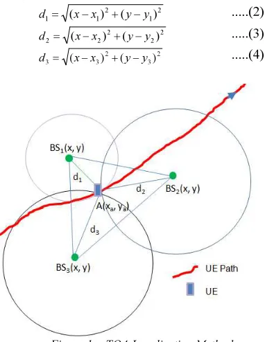
This technique needs received signals from at least three base stations. In this case, the mobile equipment is said in three hearability condition. Figure 1 shows the triangulation technology that can be used to determine the estimation location of mobile user of cellular network communication. With at least three signals from antennas of each base station, the location of the mobile equipment can be estimated. The distances between mobile equipment to each base station are denoted as d1, d2
and d3,
2 1 2 1
1 (x x) (y y)
d = − + − ...(2) 2
2 2 2
2 (x x ) (y y)
d = − + − ...(3) 2
3 2 3
3 (x x) (y y)
[image:3.595.96.287.429.676.2]d = − + − ...(4)
Figure 1: TOA Localization Method
The intersection between the three lines d1, d2
and d3 shows the estimation location of mobile
equipment, A(xa, ya) with TOA error, бtoa and can
be illustrated as in Figure 1. The TOA method requires accurate clock system and synchronization
and therefore it is normally implemented in base stations of GSM, and also GPS. In general, according to Rappaport et. al (1996), TOA technique has its drawbacks with not only requires that all transmitters and receivers in the system have precisely synchronized clocks but also the transmitting signal must be labelled with a time stamp in order for the receiver to discern the distance the signal has travelled. For this reason, EOTD and OTDOA measurements have to be taken into consideration since these techniques are a more practical means of position location with more accuracy especially for GSM and WCDMA systems.
EOTD and OTDOA Technique
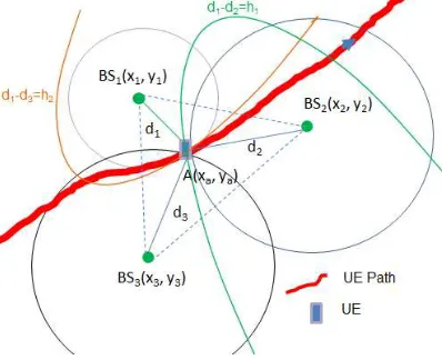
The EOTD and OTDOA positioning methods are also time-based techniques that measure the difference of transmission delay between several base stations that is synchronized while the mobile equipment or UEs are not. These techniques have been studied by many researchers that resulted with more accurate and very suitable applied in GSM and WCDMA system respectively since most of the equipment or mobile devices nowadays have been embedded with LMU unit for the synchronization purposes. In order to measure the position of mobile equipment by using these techniques, there are three parameters that have to be considered. In Rectangular coordinate system, it is assumed that the parameters involved are coordinate x and coordinate y that represents the longitude and latitude of geolocation of mobile user respectively. One more parameter that has to be considered is offset of unknown delay, τoff.
devices can be expressed as distance differences. From this, there are two Reference Signal Time Difference (RSTDs) have to be considered. The RSTD can be represented by h1 and h2 as follows;
1 2
1 1
1 RSTD d d c GTD
h = = − = × ...(5)
2 3
1 2
2 RSTD d d c GTD
h = = − = × ...(6)
Equation (7) and (8) represent the two hyperbolic equations derived from three base stations.
2 2 2 2 2
1 2 1
1 (x x) (y y) (x x ) (y y )
h = − + − − − + − ...(7) 2
3 2 3 2 1 2 1
2 (x x) (y y) (x x) (y y)
h = − + − − − + −
...(8)
According to [7], the intersection of two equations of hyperbolic is the possible location area of a mobile user or user equipment (UE). This location can be represented by coordinate A(xa, ya) with
[image:4.595.301.507.76.308.2]OTDOA error,
б
tdoa and can be illustrated inFigure 2.
Figure 2: EOTD And OTDOA Localization Method
Nowadays, as technology moving forward, people always keep moving from one place to another place. Figure 3 shows the scenario of hybrid localization technique that is needed to apply in positioning of the user equipment or mobile devices in the vicinity of GSM, WCDMA, WiMAX and LTE networks environment. When observe closely to the figure, there are at least three signals can be heard by the mobile device (UE) during its movement through the UE path.
Figure 3: Scenario Of Mobile Localization In Method
As mention earlier, according to [8], by using this method it needs received signal power from at least three base stations to estimate the position of UEs. For example in this scenario, by observing closely to Figure 3, the movement of mobile user or UE in a highway as UE path with a certain vehicular speed and its direction can be represented by the arrow directions. Along the highway (UE path) there are many base stations labeled as Base Station (BS) for GSM, Node B (NB) for WCDMA and eNode B (eNB) for LTE system, which located in a certain geographical location coordinate. In this point of attachment, the UE will receive RSCP signal power from the nearest three different base stations, BS1, BS2 and BS3. Intuitively, BS1 acts as
the serving base station since it seems that it is the nearest base station whereas BS2 and BS3 act as
[image:4.595.88.287.383.545.2]4. RESEARCH METHODOLOGY
This research started with analyzing several time-based LDT’s that suitable used for GSM, WCDMA, WiMAX and LTE system with the most accurate technique. Figure 4 shows the flowchart of general positioning activities of the user equipment or mobile device by using time-based technique.
Figure 4: Flow Chart For Mobile Positioning
For this research, time-based methods such as
EOTD or OTDOA and TOA were selected to determine the position of UEs since it is a most suitable technique for the heterogeneous networks. Then the availability of GSM, WCDMA, WiMAX and LTE base station were investigated in real location in the selected study area. For the performance of the positioning method that has been chosen, it is important to know how to analyze the accuracy of the technique.
The third activity in this study is to design software that can be used to simulate some data to estimate location of the UEs. The radius of the identified base station will be plotted from the software based on received signal strength. Then, this work will be proceed with the analysing and approximating the accuracy of positioning technique by using simulation model that has been developed. The summary of the methodology can be illustrated by flowchart as in Figure 4.
In this research, the time-based positioning technique needs at least three base stations or Node Bs to ensure that trilateration method can be done.
This condition normally called as three hearability since three Node Bs are required to generate a pair of hyperbolic equations. By using this method, according to [8] once the hyperbolic timing are calculated from location measurement unit (LMU) inputs at Node Bs, the coordinates of the convergence will be calculated.
The location of mobile user can be defined as in coordinate’s format, (x, y). RSCP is the power received by mobile device or user equipment (UE) from each base station or Node Bs and denoted as
r
P. According to J.H. Yap et al 2002, equation
below has been used to determine the power received by the base station or Node B:
) ( )
( sha
p r t t
r P G G L d u
P = + + − − σ (dB) …..(9)
Where dis the radius distance of transmitting and
receiving signals between mobile user or UE and base station or Node B. This distance d has been changed caused by path loss,L (d)
p . Gr is the
antenna gain at the location of mobile user, while
t
G is antenna gain from Node B and
t P is the transmitted power at Node B. u(σsha)is shadow
fading that varies to the random lognormal distribution with the variance of σsha. From the
equation (9), the path loss can be determined,
) ( )
( t t r r sha
p d P G G P u
L = + + − − σ (dB) …..(10)
Then, the distance between UE and Node B can be determined by using equation (11),
α β)/10* ) ( ( 10 −
= Lpd
d (meter) …..(11)
where α and β are constant values that depend on
the condition of environment. The distance between UE (x, y) and serving base station BS1(x1, y1),
BS2(x2, y2) and BS3(x3, y3) is denoted as d1, d2 and
d3 respectively and they can be determined by
using equations (2), (3) and (4) that has been discussed before.
In this case, BS1(x1, y1) is assumed to be the
serving base station whereas BS2(x2, y2) and
BS3(x3, y3) are neighbouring base stations.
be determined by solving the two hyperbolic equations of (7) and (8).
5. RESULT AND DISCUSSION
A. Drive test for simulation
Several drive test data have been observed from the route taken from Shah Alam area to the Mid Valley Kuala Lumpur along a highway. Before drive test started, the availability of the network at a selected area has to be identified. During drive test, user equipment or mobile device should be logged into the RSCP power mode. It can be shown that for any instance time, the longitude and latitude of mobile user can be observed with its related RSCP (dBm). Whereas for simulation purposes, value of Received Signal Strength Indicator (RSSI) has to be considered in the estimation of mobile user location. The RSSI is a value that takes into account both RSCP and the Ec/Io (dB) as stated in
mathematical expression in equation,
RSSI (dBm) = RSCP (dBm) – Ec/Io (dB) (12)
where Ec/Io is the ratio of the energy per chip or
code bit and the interference level that consists of total energy and noise. The drive test data which is in the form of RSSI (dBm) has to be converted into Excel format before simulation process can be done.
B. Simulation Model
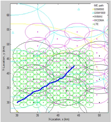
The data from drive test that has been collected from the field work area can be used in the simulation. In this study, the simulation that has been developed can be used to estimate the location of mobile user in the (x, y) coordinate form for single layer and multilayer network environments. In this work, single layer cellular network has been defined as when the mobile user is situated under three hearability of same network system. Whereas for multilayer cellular network means that the mobile user is situated under different network environments. In this case, to ensure the mobile user is in a good condition of three hearability for trilateration method, hybrid localization determination technique has to be used to determine location of the user. The locations of the base station in geographical location with longitude and latitude format were used as the input in the programme that has been developed. Then, by considering the trilateration method, the simulation model that has been developed can be used to determine the three nearest base stations at every time the mobile user moves [4].
[image:6.595.312.500.305.512.2]In the vicinity of different network environments such as GSM, WCDMA, WiMAX and LTE network, there are several Base Stations such as BS, Node Bs and eNode B have been identified. In this work, there are five types of networks have been considered i.e. GSM900, GSM1800, WCDMA, WiMAX and LTE. GSM900 and GSM1800 Base stations marked as yellow and cyan respectively. eNode B is a base station for LTE network, marked as green, and WiMAX marked as black while Node B is a base station for WDCMA network marked as magenta. The topologies of several different networks involved in this study can be illustrated as in Figure 5.
Figure 5: A Mobile User Moves Through Several Points In A Heterogeneous Network
Figure 5 shows the topology of wireless communication network that consists of five different networks i.e. GSM, WCDMA, WiMAX and LTE. The simulation shows the path of a mobile user or user equipment that moves through several points in the heterogeneous networks area. Suppose with the time-based localization method, the user can identify the nearest three base stations, even though it comes from different networks or multilayer network environments.
C. Simulation Result
simulation result of location error of the mobile user or user equipment.
Figure 6: LDT Error Vs Time
[image:7.595.106.275.157.306.2]Cumulative Density Function (CDF) has been used to identify the percentage of location error (m) of estimation of the location of the mobile user by using this hybrid method. Figure 7 shows a sample of CDF location error using the simulation model with 60 km/h of vehicular speed.There are several CDF results that indicate a positive performance of the time-based hybrid LDTs on localizing the mobile equipment with different speed in different network environments.
Figure 7: CDF Of Location Error
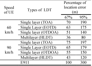
Table 1 shows the comparison between different speeds of mobile user with respect to the percentage of location error by using different location determination technology in different layer network. With the same procedure as at the first data with the speed of 60 km/h, the second data was collected along the same path with the speed of 90 km/h. It shows that the speed of mobile user also affects the accuracy of localization of mobile user.
Table 1: Location Error from Simulation Model
Speed
of UE Types of LDT
Percentage of location error
(m) 67% 95%
60 km/h
Single layer (TOA) 70 190 Single Layer (EOTD) 63 175 Single layer (OTDOA) 51 140 Multilayer (HLDT) 36 80
90 km/h
Single layer (TOA) 75 197 Single Layer (EOTD) 65 179 Single layer (OTDOA) 55 150 Multilayer (HLDT) 43 120
E911 100 300
From the result, the speed of mobile user correlates to the location error of localization. The higher the speed of mobile user, the higher the location error of estimation.
6. CONCLUSIONS
The most significant contribution of this work is the development of time-based hybrid localization determination technique that can be implemented for multilayer heterogeneous networks. In this study, the heterogeneous network has been defined as consists of GSM, WCDMA, WiMAX and LTE environments. The simulation model for location determination has been developed with time-based hybrid LDT method. It has been validated with several data of the real location of mobile users during drive test. The result shows the improvement of the location accuracy under different mobility models. The performance evaluation has been simulated and the comparison between the time-based hybrid algorithms with various LDT techniques has been done. It shows the performance of localization with improving for 67% and 95% of the obtained results that fulfil the requirements of E911. However, the result of this simulation is still not very stable since the location error depends on data value of RSCP (dBm) received by mobile device from all node Bs that is influenced by path loss. For future recommendation, the accuracy of the location determination can be optimized and further analysis need to be done.
REFRENCES:
[image:7.595.89.289.436.602.2][2] K. Yu and Y. J. Guo, “NLOS error mitigation for mobile location estimation in wireless networks,” Vehicular Technology Conference, 2007. VTC2007-Spring. IEEE 65th, pp. 1071– 1075, 2007.
[3] S.Venkatraman and J. Caffery, J., “Hybrid TOA/AOA techniques for mobile location in non-line-of-sight environments,” Wireless Communications and Networking Conference, 2004. WCNC. 2004 IEEE, vol. 1, pp. 274– 278, 2004.
[4] R.-T. Juang, D.-B. Lin, and H.-P. Lin, “Hybrid SADOA/TDOA mobile positioning for cellular networks,” Communications, IET, vol. 1, no. 2, pp. 282–287, 2007.
[5] S. Al-Jazzar and M. Ghogho, “A joint TOA/AOA constrained minimization method for locating wireless devices in non-line-of-sight environment,” Vehicular Technology Conference, 2007. VTC-2007 Fall. 2007 IEEE 66th, pp. 496–500, 2007.
[6] J. Li, J. Conan, and S. Pierre, “Mobile station location estimation for MIMO communication systems,” Wireless Communication Systems, 2006. ISWCS ’06. 3rd International Symposium on, pp. 561–564, 2006.
[7] E. Dahlman, S. Parkvall, J. Skold, and P. Berming , “3G Evolution: HSPA and LTE for Mobile Broadband”, 2nd ed., Academic Press, 2008.
[8] 3GPP TSG RAN WG1, DL OTDOA framework, R1-092010, May 2009.
[9] Jonas Medbo, Iana Siomina, Ari Kangas, Johan Furuskog, “Propogation Channel Impact on LTE Positioning Accuracy:A study based on real measurements of observed time difference of arrival.”, Ericson Research, Ericson AB, Stockholm, Sweden, PIMRC, page 2213-2217. IEEE, (2009)
[10] Tao Zhang, Dengkun Xiao, Jie Cui, Xinlong Luo, “A Novel OTDOA Positioning Scheme In Heterogeneous LTE-Advance Systems”,
IEEE, 2012.
[11] Evolved Universal Terrestrial Radio Access (E-UTRA); “Stage 2 functional specification of User Equipment (UE) positioning in E-UTRAN”, 3GPP TS 36.305.
[12] Keeratpal Singh, Mahamod Ismail, 2005. “OTDOA Location Determining Technology for Universal Intelligent Positioning System (UIPS) Implementation in Malaysia”. IEEE: 1057-1061